Maps Atlases And Charts from Madoc Books
New Arrivals
More Photos
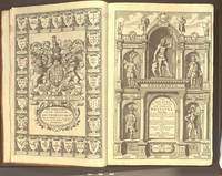
The Theatre of the Empire of Great Britaine. Presenting an Exact Geography of the Kingdomes of England. Scotland and Ireland and the Isles adjoyning..8029, viz. Asia, Africa, Europe, America with these Empires and Kingdoms therein
by SPEED John 1551/2-162
- Condition
- Used - Very Good
- Published
- 1676
- Binding
- Hardcover
- Quantity Available
- 1
- Seller
-
Llandudno, Conwy, GBR
- Item Price
-
£42,500.00
Show Details
Description:
London: at the George in Fleet-street and at the Rose and Crown in St.Paul's Church-yard: Thomas Bassett & Richard Chiswell, 1676. Hardcover. Very Good. Elephant Folio - over 15 - 23" tall. SPEED John. Regarded as a landmark in the history of British topography In 18 century sheep, gilt edge tooling, tips repaired. Re-spined… Read more about this item Item Price
£42,500.00

More Photos
Britannia, Volume the First: or, an Illustration of the Kingdom of England and Dominion of Wales:
by OGILBY John 1600-1676
- Condition
- Used - Very Good
- Published
- 1939
- Binding
- Hardcover
- Quantity Available
- 1
- Seller
-
Llandudno, Conwy, GBR
- Item Price
-
£25.00
Show Details
Description:
London & Dunstable: Alexander Duckham & Co. Ltd., 1939. Hardcover. Very Good. 4to - over 9¾ - 12" tall. OGILBY John. Facsimile reduction of Ogilby's road maps 1939, VG, in oblong, cream cloth, red cloth tile with gilt tooling. Spine, edges bumped & worn, worn red cloth title label, lettering faded. Internally, [7],… Read more about this item Item Price
£25.00

More Photos
Plans of the Ports of England & Wales (manuscript)
by GMB?
- Condition
- Used - Very Good
- Published
- 1866
- Binding
- Hardcover
- Quantity Available
- 1
- Seller
-
Llandudno, Conwy, GBR
- Item Price
-
£1,450.00
Show Details
Description:
1866. Hardcover. Very Good. Elephant Folio - over 15 - 23" tall. GMB?. Eighty Three Attractive Hand Drawn Maps of the English & Welsh Ports, coloured in outline VG+, 1866-1881, large oblong, half calf over contemporary maroon cloth, contemporary gilt title & tooling to black morocco label, some blind tooling. Spine, gilt titles &… Read more about this item Item Price
£1,450.00

More Photos
Chart of St. George's Channel
by MORRIS Lewis 1701-1765. MORRIS William 1758-1808
- Condition
- Used - Very Good
- Edition
- 2nd Edition
- Published
- 1800
- Binding
- No Binding
- Quantity Available
- 1
- Seller
-
Llandudno, Conwy, GBR
- Item Price
-
£1,250.00
Show Details
Description:
[Shrewsbury]: William Morris, 1800. 2nd Edition . No Binding. Very Good. Oblong. MORRIS Lewis. MORRIS William. Uncommon, WorldCat shows 2 copies only n institutions (St Davids & NLW). Very large copperplate engraved folded map on thick paper, blue paper backing, light stain to bottom left corner, occasional light spot. All housed in a half blue… Read more about this item Item Price
£1,250.00

More Photos
A New Description of England and Wales, with the adjacent islands. Wherein are contained, diverse useful observations and discoveries in respect to natural history, antiquities, customs, honours, privileges, &c. with a particular account of the products, trade, and manufactures
by MOLL Herman c1654-1732
- Condition
- Used - Very Good
- Edition
- 1st Edition 1st Printing
- Published
- 1724
- Binding
- Hardcover
- Quantity Available
- 1
- Seller
-
Llandudno, Conwy, GBR
- Item Price
-
£5,250.00
Show Details
Description:
London: over-against Devereux-Court in the Strand: H. Moll, 1724. 1st Edition 1st Printing. Hardcover. Very Good. Folio - over 12 - 15" tall. MOLL Herman. WITH TWO GENERAL AND FORTY EIGHT COUNTY MAPS The rare first edition, first issue (maps not coloured or numbered), 1724, in full contemporary panelled calf, tips repaired. Re-cased, retaining the old, raised bands,… Read more about this item Item Price
£5,250.00

More Photos
Brittania: or, a chorographical description of Great Britain and Ireland together with the adjacent islands
by CAMDEN William 1551-1623. GIBSON Edmund 1669-1748.
- Condition
- Used - Very Good
- Edition
- 3rd Edition
- Published
- 1753
- Binding
- Hardcover
- Quantity Available
- 1
- Seller
-
Llandudno, Conwy, GBR
- Item Price
-
£500.00
Show Details
Description:
London:: R. Ware, J. and P. Knapton, T. Longman, C. Hitch, Etc., 1753. 3rd Edition . Hardcover. Very Good. Elephant Folio - over 15 - 23" tall. CAMDEN W.. WITH THIRTY SIX FOLDING MAPS BY MORDEN AND TEN PLATES OF COINS VG+. The third edition, Volume 1 ONLY (of 2), in modern red half… Read more about this item Item Price
£500.00

More Photos
Cary's New and Correct English Atlas: Being a New Set of County Maps from Actual Surveys. Exhibiting all the direct & principal cross roads, cities, towns, and most considerable villages, parts, rivers, navigable canals &c.
by CARY John 1754-1835
- Condition
- Used - Very Good
- Edition
- 2nd Edition
- Published
- 1793
- Binding
- Hardcover
- Quantity Available
- 1
- Seller
-
Llandudno, Conwy, GBR
- Item Price
-
£800.00
Show Details
Description:
London: near Norfolk Street. Strand John Cary 1793: J Cary, 1793. 2nd Edition . Hardcover. Very Good. Folio - over 12 - 15" tall. CARY John. Second edition, quarto, [2] blank, [190], 17, [3] blank, including forty seven full page maps, all outlined in colour, each map with tissue guard. Modern full light brown buckram, spine stamped in… Read more about this item Item Price
£800.00

More Photos
Plans of the Principal Harbours, Bays, & Roads, in St. George's and the Bristol Channels. Plans of the principal harbours, bays, & roads, in St. George's and the Bristol Channels... Together with Some Useful Tables for Mariners
by MORRIS Lewis [Llewelyn Ddu o Fo^n]1701-1765. and MORRIS William 1758-1808
- Condition
- Used - Very Good
- Published
- 1801
- Binding
- Hardcover
- Quantity Available
- 1
- Seller
-
Llandudno, Conwy, GBR
- Item Price
-
£1,500.00
Show Details
Description:
Shrewsbury: Printed for the Author, By Sandford and Maddocks, 1801. Hardcover. Very Good. Folio - over 12 - 15" tall. The Welsh Coastline revealed Shrewsbury, Printed for the Author, By Sandford and Maddocks. 1801 A New Edition, in black cloth, gilt titles to spine. Internally, [5], (vi-xii), [1], 2-21 pp, [1],… Read more about this item Item Price
£1,500.00

More Photos
Holyhead Harbour of Refuge
by The Commissioners Appointed by the Board of Admiralty
- Condition
- Used - Very Good
- Published
- 1847
- Binding
- Hardcover
- Quantity Available
- 1
- Seller
-
Llandudno, Conwy, GBR
- Item Price
-
£500.00
Show Details
Description:
The Commissioners Appointed by the Board of Admiralty, 1847. Hardcover. Very Good. Folio - over 12 - 15" tall. FASCINATING INSIGHT INTO A MAJOR DEVELOPMENT PROJECT IN THE MID 1800'S In worn black cloth. corners bumped, gilt title to spine. Internally, [Approval of Plan] [1], 2-4), Chart No 1, & No 2 (signed - Rendel), [1] blank, [1]… Read more about this item Item Price
£500.00

More Photos
Kuwait-Iraq Boundary Dispute in British Archives
by Al-A'DAMI WMS. Hamdi Dr.
- Condition
- Used - Near Fine
- Jacket Condition
- Very Good
- Edition
- 1st Edition
- Published
- 1993
- Binding
- Hardcover
- Quantity Available
- 1
- Seller
-
Llandudno, Conwy, GBR
- Item Price
-
£400.00
Show Details
Description:
London 90 Chalton Street London NW1: Quick Print, Archives and Research Centre, 1993. 1st Edition . Hardcover. Near Fine/Very Good. 4to - over 9¾ - 12" tall. First edition, two volumes in red cloth, gilt printed titles to green cloth on spines. In fine printed dust wrappers. Internally, Vol 1, [2], 7-550 pp. Vol 2, [4], 7-21,… Read more about this item Item Price
£400.00

More Photos
The Imperial Guide, with Picturesque Plans of the Great Post Roads.....
by BAKER J [James]
- Condition
- Used - Very Good
- Binding
- Hardcover
- Quantity Available
- 1
- Seller
-
Llandudno, Conwy, GBR
- Item Price
-
£850.00
Show Details
Description:
Hardcover. Very Good. 8vo - over 7¾ - 9¾" tall. BAKER J. JAMES H. GRIFFITHS M. IBBETSON. London to Holyhead ONLY In modern quarter blue buckram oe marbled boards, gilt title on black calf to spine (Picturesque Plans), Internally, vignette half title, [1], 2-10 pp, only, 12 plates (includes… Read more about this item Item Price
£850.00
More Photos
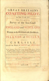
Great Britain's coasting pilot. In two parts. Being a new and exact survey of the sea-coast of England and Scotland from the river of Thames to the westward and northward with the islands of Scilly and from thence to Carlyle. Likewise the islands of Orkney and Shetland
by COLLINS Greenvile Captain [or Greenville] 1643-1694
- Condition
- Used - Very Good
- Published
- 1744
- Binding
- Hardcover
- Quantity Available
- 1
- Seller
-
Llandudno, Conwy, GBR
- Item Price
-
£9,500.00
Show Details
Description:
London: Tower-Hill: William Mount and Thomas Page, 1744. Hardcover. Very Good. Elephant Folio - over 15 - 23" tall. COLLINS Greenvile Captain. A Landmark in the Charting of Great Britain. Folio, 18th century mottled half calf over blue-green marbled paper boards, decorative gilt spine, red morocco lettering piece, pp. [iv] + 26. Fine allegorical copperplate title (incorporating a… Read more about this item Item Price
£9,500.00

More Photos
The Ports, Harbours, Watering-Places, and Coast Scenery of Great Britain.
by BEATTIE William 1793-1875
- Condition
- Used - Near Fine
- Published
- 1842
- Binding
- Hardcover
- Quantity Available
- 1
- Seller
-
Llandudno, Conwy, GBR
- Item Price
-
£1,100.00
Show Details
Description:
London: Ivy-Lane: George Virtue, 1842. Hardcover. Near Fine. 4to - over 9¾ - 12" tall. BARTLETT W.H. 1809-1854. HARDING. CRESWICK, COOKE. and BALMER.. Superbly bound, with 1 engraved portrait, 2 eng. title pages with vignettes, and 123 engraved plates. 2 Volumes in near fine condition, full dark purple morocco, c1920, gilt edge and decorative tooling, edges brushed. Spines,… Read more about this item Item Price
£1,100.00

More Photos
The Second Booke: Containing the Principality of Wales. Delivering, An exact Topographie of the Counties. Diuisions of their Cantreves, and Commots. Descriptions of their Cities, and Shire-Townes
by SPEED John 1552?-1629.
- Condition
- Used - Very Good
- Published
- 1611
- Binding
- Hardcover
- Quantity Available
- 1
- Seller
-
Llandudno, Conwy, GBR
- Item Price
-
£5,250.00
Show Details
Description:
London,: John Sudburie and George Humble, 1611. Hardcover. Very Good. Elephant Folio - over 15 - 23" tall. SPEED John. Speed's Principality of Wales with Fourteen Double Page Maps In modern full black morocco (by Bayntun), decorative edge tooling. Spine, raised bands, gilt tooling & titles. Internally, [1] ff Royal Stemme & verso County… Read more about this item Item Price
£5,250.00
![Theatrum Orbis Terrarum. sive Atlas Novus. Pars Quarta [England & Wales]](https://d3525k1ryd2155.cloudfront.net/h/552/720/1492720552.0.m.0.jpg)
More Photos
Theatrum Orbis Terrarum. sive Atlas Novus. Pars Quarta [England & Wales]
by BLAEU Johannes & Guillaume 1596-1673 & 1571-1638
- Condition
- Used - Very Good
- Edition
- 2nd Edition
- Published
- 1646
- Binding
- Hardcover
- Quantity Available
- 1
- Seller
-
Llandudno, Conwy, GBR
- Item Price
-
£8,750.00
Show Details
Description:
Amsterdami: Johannem Blaeu, 1646. 2nd Edition . Hardcover. Very Good. Elephant Folio - over 15 - 23" tall. BLAEU Johannes & Guillaume. In contemporary Dutch full boxed vellum, retaining evidence of green linen ties, yapp edges, a few minor scuffs & marks, near contemporary faint manuscript title to spine. Internally, title leaf, [8], 460, [1], ie: engraved allegorical… Read more about this item Item Price
£8,750.00
![Atlas of the Counties of England and Wales [MS maps]](https://d3525k1ryd2155.cloudfront.net/h/831/011/1475011831.0.m.jpg)
More Photos
Atlas of the Counties of England and Wales [MS maps]
by HOLDEN R.G.
- Condition
- Used - Near Fine
- Binding
- Hardcover
- Quantity Available
- 1
- Seller
-
Llandudno, Conwy, GBR
- Item Price
-
£675.00
Show Details
Description:
Hardcover. Near Fine. 24mo - over 5 - 5¾" tall. HOLDEN R.G.. With Forty Two Manuscript Maps Small octavo, manuscript title page and forty two county maps in light red, blue and yellow, town and place names written in an extremely neat hand, not dated but circa 1800, contemporary half calf over mottled boards, expertly rebacked to style,… Read more about this item Item Price
£675.00

FFESTINIOG Railway
- Condition
- Used - Very Good
- Binding
- No Binding
- Quantity Available
- 1
- Seller
-
Llandudno, Conwy, GBR
- Item Price
-
£50.00
Show Details
Description:
No Binding. Very Good. Uncommon Local Railway item. Draft(?) MS manuscript long section of a proposed (narrow gauge?) railway from Llanrwst to the Blaenau Festiniog Quarries nearly 14 miles long. Not titled or dated, but probably early 1860s. Size 60" x 17", ink on glazed tracing cloth, lettered 'Section of Ffestiniog Railway' on reverse.
Item Price
£50.00

More Photos
Sailing Directions for the Coast of Wales
by SHERINGHAM WL. ROBINSON CG. DENHAM HM
- Condition
- Used - Very Good
- Edition
- 1st Edition 1st Printing
- Published
- 1843
- Binding
- Hardcover
- Quantity Available
- 1
- Seller
-
Llandudno, Conwy, GBR
- Item Price
-
£225.00
Show Details
Description:
London:: The Hydrographic Office, Admiralty, 1843. 1st Edition 1st Printing. Hardcover. Very Good. 8vo - over 7¾ - 9¾" tall. Uncommon, VG+, 1st ed, 1843. no other copy for sale online or at auction for a very long time. In modern half calf & tips (to style), over red marbled boards, some blind tooling. Spine,… Read more about this item Item Price
£225.00

More Photos
Sailing Directions from Point Lynas to Liverpool with Charts, Coast-views, River-Sections... for navigating the Dee and Mersey WITH Remarks... The Sea-Reach of Wyre up to Port Fleetwood
by DENHAM H.M. [Henry Mangles] Commander R.N. 1800-1887
- Condition
- Used - Very Good
- Edition
- 1st Edition
- Published
- 1840
- Binding
- Hardcover
- Quantity Available
- 1
- Seller
-
Llandudno, Conwy, GBR
- Item Price
-
£400.00
Show Details
Description:
Liverpool: J. & J. Mawdsley, 1840. 1st Edition . Hardcover. Very Good. 8vo - over 7¾ - 9¾" tall. CHEFFINS C.F. . Uncommon, 24 plates (of 25), 1840. In contemporary green cloth, gilt title to upper board. Re-spined, old laid down, gilt titles. Internally, engraved title page with vignette, [2], [1], (ii-xx), [2],… Read more about this item Item Price
£400.00

More Photos
Hunting Map. The Marquis of Anglesey's Harriers.
by Marquis of Anglesey
- Condition
- Used - Very Good
- Edition
- 1st Edition
- Binding
- Hardcover
- Quantity Available
- 1
- Seller
-
Llandudno, Conwy, GBR
- Item Price
-
£195.00
Show Details
Description:
Chester: Phillipson & Golder. 1st Edition . Hardcover. Very Good. 32mo - over 4 - 5" tall. In red cloth, gilt titles & emblems, mark to lower board, no spine title. Internally, [2], [4] places of meeting, [2] blanks, followed by folding coloured map (12 panes), yellow endpapers, not dated but possibly 1894. (covers 106*61 mm. Map 217*295… Read more about this item Item Price
£195.00
