Description:
Geological Society, 1914. Soft cover. Good. Coloured map of the Greek Islands, 1:1,000,000, GSGS 3694, with a pronunciation chart to margins, 61.2*70 cm, couple of crease tears.
Search Results: Maps Atlases and Charts from Madoc Books
You searched for:
- Subject: Maps Atlases and Charts from Madoc Books
Results 1 - 20 of 41

The Aegean Sea
by Geographical Society
- Used
- good
- Paperback
- Condition
- Used - Good
- Binding
- Paperback
- Quantity Available
- 1
- Seller
-
Llandudno, Conwy, United Kingdom
- Item Price
-
£25.00£30.00 shipping to USA
Show Details
Item Price
£25.00
£30.00
shipping to USA

More Photos
An Atlas of Modern Geography
by BUTLER Samuel 1774-1839
- Used
- very good
- Hardcover
- Condition
- Used - Very Good
- Binding
- Hardcover
- Quantity Available
- 1
- Seller
-
Llandudno, Conwy, United Kingdom
- Item Price
-
£175.00£30.00 shipping to USA
Show Details
Description:
London:: Longman, Rees, Orme, Brown & Green., 1829. Hardcover. Very Good. 8vo - over 7¾ - 9¾" tall. BUTLER Samuel. HALL Sidney - engarver 1788-1831. 1829, VG, 21 of 22 maps. In modern straight grained dark blue half morocco, over contemporary worn purple cloth, edges bumped. Internally, [1] engraved index, [1], 21 of 22 double page maps (lacks Europe), hand coloured to outline, [2], (31) index, [1], lacks the engraved titlepage, maps dated 1829, relief shown by hachures, neat paper repair to world map margin tear & crease, ink name to fep (George Clifford? Malden Essex) printed by A. & R. Spottiswoode, New-Street-Square, London. 1st edition printed in 1825? (144*208 mm). (Worms/Williams - British Map engravers p291/2)
Item Price
£175.00
£30.00
shipping to USA
![Atlas of the Counties of England and Wales [MS maps]](https://d3525k1ryd2155.cloudfront.net/h/831/011/1475011831.0.m.jpg)
More Photos
Atlas of the Counties of England and Wales [MS maps]
by HOLDEN R.G.
- Used
- near fine
- Hardcover
- Condition
- Used - Near Fine
- Binding
- Hardcover
- Quantity Available
- 1
- Seller
-
Llandudno, Conwy, United Kingdom
- Item Price
-
£675.00£30.00 shipping to USA
Show Details
Description:
Hardcover. Near Fine. 24mo - over 5 - 5¾" tall. HOLDEN R.G.. With Forty Two Manuscript Maps Small octavo, manuscript title page and forty two county maps in light red, blue and yellow, town and place names written in an extremely neat hand, not dated but circa 1800, contemporary half calf over mottled boards, expertly rebacked to style, smooth spine ruled in gilt and with red morocco gilt morocco spine label. (134*102 mm). Although not much can be determined concerning RG Holden, we can state with assuredness that he was an excellent draftsman. The maps are well delineated and with precise lettering. With a gift inscription to fpd "Joanna Holden a gift from her affectionate son R. Holden.
Item Price
£675.00
£30.00
shipping to USA

More Photos
An Atlas to Guthrie's Geographical Grammar.
by [GUTHRIE William 1708-1770. FLINT W.]
- Used
- very good
- Hardcover
- Condition
- Used - Very Good
- Binding
- Hardcover
- Quantity Available
- 1
- Seller
-
Llandudno, Conwy, United Kingdom
- Item Price
-
£600.00£30.00 shipping to USA
Show Details
Description:
London:: J. Johnson; F. and C. Rivington; etc, 1807. Hardcover. Very Good. GUTHRIE William. VG, 1807, complete 28 double page folding maps, hand coloured in outline. In modern half calf over contemporary marbled boards, some blind tooling. Spine, gilt tooling & titles. Internally, title page, [1] blank, 28 double page folding maps complete (including the map of the world and the Armillary Sphere), all hand coloured in outline, ink name to fpd (Hugh Hutton Glasgow 1814) & also to TP (then Hugh Hutton Warrington 1820) front & verso of maps numbered then referenced on tp list, some paper repairs, printed by W. Flint, Old Bailey. 1st published in 1771. (144*216 mm). (not in Worms). Guthrie, historian and political journalist whose most successful work, was his Geographical, Historical, and Commercial Grammar (1770). See ODNB.
Item Price
£600.00
£30.00
shipping to USA
More Photos
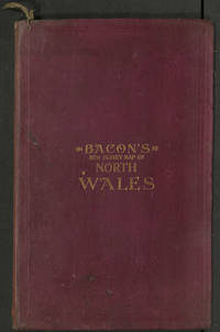
Bacon's New Library Map of North Wales
by BACON
- Used
- very good
- Hardcover
- Condition
- Used - Very Good
- Binding
- Hardcover
- Quantity Available
- 1
- Seller
-
Llandudno, Conwy, United Kingdom
- Item Price
-
£60.00£30.00 shipping to USA
Show Details
Description:
London: 127, Strand: G.W. Bacon & Co. Hardcover. Very Good. Coloured map, mounted on linen, 15 panels, 952 * 704 mm, folded into a red cloth, gilt printed case, 317 *196 mm, with the Alphabetical Index to Town attached. not dated but c1900, Uncommon, not listed at WorldCat, Copac or OCLC.
Item Price
£60.00
£30.00
shipping to USA

More Photos
Britannia, Volume the First: or, an Illustration of the Kingdom of England and Dominion of Wales:
by OGILBY John 1600-1676
- Used
- very good
- Hardcover
- Condition
- Used - Very Good
- Binding
- Hardcover
- Quantity Available
- 1
- Seller
-
Llandudno, Conwy, United Kingdom
- Item Price
-
£25.00£30.00 shipping to USA
Show Details
Description:
London & Dunstable: Alexander Duckham & Co. Ltd., 1939. Hardcover. Very Good. 4to - over 9¾ - 12" tall. OGILBY John. Facsimile reduction of Ogilby's road maps 1939, VG, in oblong, cream cloth, red cloth tile with gilt tooling. Spine, edges bumped & worn, worn red cloth title label, lettering faded. Internally, [7], [1] Map of England, followed by 100 maps (coloured & numbered), all within double red in ruled borders, publishers printed note to fpd (with reasoning for the issue). (241*309 mm). Title continues: An illustration of the kingdom of England and dominion of Wales : by a geographical and historical description of the principal roads thereof. Actually admeasured and delineated in a century of whole-sheet copper-sculps. Accommodated with the ichnography of the several cities and capital towns ; and completed by an accurate account of the more remarkable passages of antiquity, together with a novel discourse of the present state REDUCED
Item Price
£25.00
£30.00
shipping to USA

More Photos
Brittania: or, a chorographical description of Great Britain and Ireland together with the adjacent islands
by CAMDEN William 1551-1623. GIBSON Edmund 1669-1748.
- Used
- very good
- Hardcover
- Condition
- Used - Very Good
- Edition
- 3rd Edition
- Binding
- Hardcover
- Quantity Available
- 1
- Seller
-
Llandudno, Conwy, United Kingdom
- Item Price
-
£500.00£30.00 shipping to USA
Show Details
Description:
London:: R. Ware, J. and P. Knapton, T. Longman, C. Hitch, Etc., 1753. 3rd Edition . Hardcover. Very Good. Elephant Folio - over 15 - 23" tall. CAMDEN W.. WITH THIRTY SIX FOLDING MAPS BY MORDEN AND TEN PLATES OF COINS VG+. The third edition, Volume 1 ONLY (of 2), in modern red half calf (by Delrue), over grey cloth, some blind tooling. Spine, raised bands, gilt titles to black calf labels. Internally, portrait frontis, rubricated title, (Signatures: B-6Z2), or [33], (cclxvii), [1] ff, 2 columns per page, 695 columns, number continuously, 36 maps (all folding, by Morden), 15 pls (including 10 of coins), new endpapers, text block edges reddened, numerous illustrations within text. Maps by Robt. Morden An excellent example. (392*237 mm). (ESTC T145183. Maslen and Lancaster. Bowyer ledgers, 3810) [ref: 623] £750
Item Price
£500.00
£30.00
shipping to USA

More Photos
Camden's Wales
by CAMDEN William 1551-1623
- Used
- very good
- Hardcover
- Condition
- Used - Very Good
- Edition
- Limited Edition
- Binding
- Hardcover
- Quantity Available
- 1
- Seller
-
Llandudno, Conwy, United Kingdom
- Item Price
-
£25.00£30.00 shipping to USA
Show Details
Description:
Carmarthen: Rampart Press, 1984. Limited Edition . Simulated Leather. Very Good. Folio - over 12" - 15" tall. VG, Ltd ed, 1984. In simulated red leather with gilt title and lots of gilt tooling. Internally NO inscriptions etc, 4 small spots indicating bookplate removal, 94 pp. A lovely, limited edition, enlarged facsimile copy of the original Camden title of which there were 500 copies produced. Title continues: Being the Welsh chapters taken from Edmund Gibson's revised & enlarged edition of William Camden's Britannia (1722). Translated from the Latin, with additions by Edward Llhuyd, with maps executed by Robert Morden. With an introductory essay by Gwyn Walters, compiled and set and printed by Terrence James at the Rampart Press.
Item Price
£25.00
£30.00
shipping to USA

More Photos
Carte Routiere de la Suisse. Road Map of Switzerland. Reisekarte der Schweiz. No 367.
by KELLER H [Heinrich] 1778-1862. AUDIN Jean Narie Vincent 1793-1851
- Used
- very good
- Condition
- Used - Very Good
- Quantity Available
- 1
- Seller
-
Llandudno, Conwy, United Kingdom
- Item Price
-
£425.00£30.00 shipping to USA
Show Details
Description:
Rue de Bac No 6, Paris: Audin; J. Goujon;, 1828. No Binding. Very Good. VG, 1828. 16 panels, linen mounted, hand coloured in outline, each corner with boxed route + 1 other, in custom folding case with the 2 text leaves mounted inside, title & publishers details to verso, with the repaired original cover with title to spine. First published under this title in 1813. (680*507 mm).
Item Price
£425.00
£30.00
shipping to USA

More Photos
Carte de la navigation interieure de la France presentant le classement du reseau navigable en lignes principales et secondaires.
by Ministres des travaux publics
- Used
- very good
- Hardcover
- Condition
- Used - Very Good
- Binding
- Hardcover
- Quantity Available
- 1
- Seller
-
Llandudno, Conwy, United Kingdom
- Item Price
-
£150.00£30.00 shipping to USA
Show Details
Description:
London: 26 & 27, Cockspur St. Charing Cross. SW.: Edward Stanford, 1890. Hardcover. Very Good. VG+ condition, 1890. 45 linen backed panels, in all 113.5*88.8 cms, 1:1 250 000, coloured, with smaller maps of the Environs de Paris, de Lille & La Corse 1:500.000, printed by Regnier, 121 R. de Rennes (Paris), housed in its original slip case. Uncommon. Copies at BL & BnF.
Item Price
£150.00
£30.00
shipping to USA

More Photos
Cary's New and Correct English Atlas: Being a New Set of County Maps from Actual Surveys. Exhibiting all the direct & principal cross roads, cities, towns, and most considerable villages, parts, rivers, navigable canals &c.
by CARY John 1754-1835
- Used
- very good
- Hardcover
- Condition
- Used - Very Good
- Edition
- 2nd Edition
- Binding
- Hardcover
- Quantity Available
- 2
- Seller
-
Llandudno, Conwy, United Kingdom
- Item Price
-
£800.00£30.00 shipping to USA
Show Details
Description:
London: near Norfolk Street. Strand John Cary 1793: J Cary, 1793. 2nd Edition . Hardcover. Very Good. Folio - over 12 - 15" tall. CARY John. Second edition, quarto, [2] blank, [190], 17, [3] blank, including forty seven full page maps, all outlined in colour, each map with tissue guard. Modern full light brown buckram, spine stamped in black and gilt. Some foxing throughout, a few short closed tears. A near fine atlas. London or Greenwich meridians. Relief shown by hachures. Descriptions of the counties include lists of seats and views. Includes lists of market and borough towns, with market days and distances from London, and principal post and sub-post towns with their receiving houses and times of arrival and departure. (320*244 mm). (Tooley 57/71. Lister 43). Title continues: shewing the connexion of one map with another also a general description of each county and with the junction of the roads from one county to another.
Item Price
£800.00
£30.00
shipping to USA

More Photos
Chart of St. George's Channel
by MORRIS Lewis 1701-1765. MORRIS William 1758-1808
- Used
- very good
- Condition
- Used - Very Good
- Edition
- 2nd Edition
- Quantity Available
- 1
- Seller
-
Llandudno, Conwy, United Kingdom
- Item Price
-
£1,250.00£30.00 shipping to USA
Show Details
Description:
[Shrewsbury]: William Morris, 1800. 2nd Edition . No Binding. Very Good. Oblong. MORRIS Lewis. MORRIS William. Uncommon, WorldCat shows 2 copies only n institutions (St Davids & NLW). Very large copperplate engraved folded map on thick paper, blue paper backing, light stain to bottom left corner, occasional light spot. All housed in a half blue morocco over blue marbled boards box, gilt titles to spine, gilt titles to red morocco label to upper board. Engraved by Wm. Simpkins, Clements Inn. Shows rhumb lines, soundings, drying and submerged banks, tide information, anchorage's and illustrations of ships. Sea area of Bristol Channel and Irish Sea, Cardiff to Liverpool, Wexford to Dublin. (895*897 mm). (Evans, Olwen Caradoc - Marine plans & charts of Wales p32.No106. Dr R ColleyThe Map Collector v8, p32/36. 'Lewis Morris....), Chart Maker Extraordinary.. ) Title continues: To the right honourable the Lords Commissioners for executing the office of Lord High Admiral of Great…
Read More Item Price
£1,250.00
£30.00
shipping to USA

Coast of Wales: Cardigan Bay: Milford Haven-Holyhead
by COLLINS Captain Greenvile [died 1694]
- Used
- very good
- Condition
- Used - Very Good
- Quantity Available
- 1
- Seller
-
Llandudno, Conwy, United Kingdom
- Item Price
-
£225.00£30.00 shipping to USA
Show Details
Description:
London: J Mount, T Page & W Mount, 1779. No Binding. Very Good. 60 * 49.5 Cm. Single sheet showing Welsh Coast line from Pembroke up to Penmaen Mawr & Anglesey, shows rhumb lines, coastal soundings, compass rose, dedication to Sr. Clodisley Shouell and Rear Admiral of the Blew in a coloured horizontal oval cartouche, tree to background, red flowers to foreground, cherub to right, scale below cartouche, across the top there are 5 panels showing the coastal profiles of Ramsey Island, Scamor, Grasholm, Barzey Island and St Brides, central vertical fold. Excellent condition, clean with wide margins. In the top, left corner of the boxes there is the number 26 which I presume indicates the page number for this chart within Collin's Great Britain's Coasting Pilot)
Item Price
£225.00
£30.00
shipping to USA
More Photos
Diverses Cartes et Tables pour La Geographie Ancienne pour La Chronologie et pour Les Itineraires et Voyages Modernes.
by DUVAL P [Pierre] 1619-1682
- Used
- very good
- Hardcover
- Condition
- Used - Very Good
- Binding
- Hardcover
- Quantity Available
- 1
- Seller
-
Llandudno, Conwy, United Kingdom
- Item Price
-
£3,400.00£30.00 shipping to USA
Show Details
Description:
Paris, en l'isle du Palais, sur le Quay de l'Orloge, au coin de la Rue de Harlay.: Chez l'Auteur. Hardcover. Very Good. Oblong. DUVAL P. BRISSART P. (LAPOINTE F. SOMER. VG+, c1670's, 57 pls & maps. The Royal Geographer who attacks traditional preconceptions concerning France's maritime weakness. In contemporary worn full calf. Spine, raised bands, decorative gilt tooling, gilt title. Internally, 2 engraved title page leaves, [1] ff dedication, [1] ff History, 27 pls, [2] ff index, [1] engraved tp for La Chronologie, 14 ff (list), [2] ff (Princes list), 27 pls (inclusive of tp), i tp with Brissart 73, indicating 1673?, some light edge browning, contemporary ink name (crossed out) to 1st titlepage, text block edges sprinkled red, gilt tooling to board edges. Repairs to head & tail of spine & tips, hand sewn headband. Uncommon, I can only find 2 undated editions on OCLC 1671 @ Cambridge & 1680 @ the BL? (Oval, 294*203 mm).
Item Price
£3,400.00
£30.00
shipping to USA

More Photos
Flint Comitatus
by SAXTON Christopher 1542/4-1610/11
- Used
- very good
- Hardcover
- Condition
- Used - Very Good
- Binding
- Hardcover
- Quantity Available
- 1
- Seller
-
Llandudno, Conwy, United Kingdom
- Item Price
-
£75.00£30.00 shipping to USA
Show Details
Description:
1637. Boards. Very Good. William Kip. Actual Map size 31.5*26 cm, mounted 42.5*37 cm, copper engraving highlighted in colour by hand, with a decorative title cartouche, Scala Miliarium and shaded seas, center crease. Saxton, Christopher, map maker and in producing a complete set of county maps of England and Wales, brought to fruition an idea that had been long germinating. Map-consciousness had been growing in the minds of statesmen, developing simultaneously with surveying techniques. Saxton's county maps gained instant recognition at the highest political levels-even while they were still in course of production, between 1574 and 1578, Lord Burghley pulled and annotated early proofs. Saxton's maps were planimetrically superior to those of his predecessors. See ODNB for a full Bio.
Item Price
£75.00
£30.00
shipping to USA

More Photos
Great Britain's Coasting Pilot (Welsh Coast only - 8 sheets)
by COLLINS Captain Greenvile [died 1694]
- Used
- very good
- first
- Condition
- Used - Very Good
- Quantity Available
- 1
- Seller
-
Llandudno, Conwy, United Kingdom
- Item Price
-
£2,400.00£30.00 shipping to USA
Show Details
Description:
No Binding. Very Good. Elephant Folio - over 15 - 23" tall. MOXON J COLLINS J. WELSH Coast only. The First edition of the maps was in 1693, the first Sea Atlas produced by an Englishman and was reissued numerous times over the next hundred years. The maps in this offer make up 8 loose center fold charts of the Welsh Coast, not dated but c1750s, on thick heavy paper, 50*59 cms, no water marks, copper engravings, most showing a compass rose, rhumb lines, sailing boats, un-coloured, all with large decorative cartouches. They are: Not numbered - St Georges Channel, No 24 Milford-Haven, No 25 Milford Haven and the Islands Adjacent, 26 Cardigan Bay, 27 Holy-Head Part of the Island of Anglesey in North Wales, 28 P. of Carnarvan Shire, 29 The Isle of Man, 30 The River Dee or Chester-Water. All have a couple of tiny pin pricks to top left & right corners and a couple have a tiny pin prick to the maps -plotting?-. No date or edition stated. Housed in a large protective up and over box covered in brown…
Read More Item Price
£2,400.00
£30.00
shipping to USA
More Photos
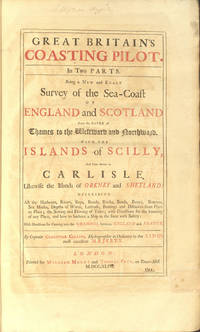
Great Britain's coasting pilot. In two parts. Being a new and exact survey of the sea-coast of England and Scotland from the river of Thames to the westward and northward with the islands of Scilly and from thence to Carlyle. Likewise the islands of Orkney and Shetland
by COLLINS Greenvile Captain [or Greenville] 1643-1694
- Used
- very good
- Hardcover
- Condition
- Used - Very Good
- Binding
- Hardcover
- Quantity Available
- 1
- Seller
-
Llandudno, Conwy, United Kingdom
- Item Price
-
£9,500.00£30.00 shipping to USA
Show Details
Description:
London: Tower-Hill: William Mount and Thomas Page, 1744. Hardcover. Very Good. Elephant Folio - over 15 - 23" tall. COLLINS Greenvile Captain. A Landmark in the Charting of Great Britain. Folio, 18th century mottled half calf over blue-green marbled paper boards, decorative gilt spine, red morocco lettering piece, pp. [iv] + 26. Fine allegorical copperplate title (incorporating a small map of the British Isles), letter press title printed in red & black, 47 copperplate charts & profiles (5 folding, 3 single page, the remainder double page) and one chart in the text (at p18). A couple of the folding maps just torn at fold, some browning and offsetting, text spotted in places, but still a handsome copy. First published in 1693 and reissued many times throughout the eighteenth century, this formidable and costly project, [was] the first systematic survey of British coastal waters (Moreland & Bannister, Antique Maps, 3rd ed p163). (511*322 mm). (Phillips 5199. Moreland & Bannister).…
Read More Item Price
£9,500.00
£30.00
shipping to USA

More Photos
Holyhead Harbour of Refuge
by The Commissioners Appointed by the Board of Admiralty
- Used
- very good
- Hardcover
- Condition
- Used - Very Good
- Binding
- Hardcover
- Quantity Available
- 1
- Seller
-
Llandudno, Conwy, United Kingdom
- Item Price
-
£500.00£30.00 shipping to USA
Show Details
Description:
The Commissioners Appointed by the Board of Admiralty, 1847. Hardcover. Very Good. Folio - over 12 - 15" tall. FASCINATING INSIGHT INTO A MAJOR DEVELOPMENT PROJECT IN THE MID 1800'S In worn black cloth. corners bumped, gilt title to spine. Internally, [Approval of Plan] [1], 2-4), Chart No 1, & No 2 (signed - Rendel), [1] blank, [1] Return. Copy of the Report of the Commissioners... to investigate Mr. Rendel's Plan for a Harbour of Refuge at Holyhead, 1847, [2], 3-44, Chart Appendix D Holyhead Harbour, Chart Appendix E1, Chart Appendix F1, Chart Appendix F3, Chart Appendix G1, Minutes of the Evidence... [2], 47-89 pp, [1] blank, [1] Table. Hinges strengthened with tape, small library stamp to pls. (325*209 mm). Chart No 1: [Folding] Holyhead Harbour Chart of the Proposed site for harbour shewing results of the examination of the bottom By W. Downs, Diver. Chart No 2: [Folding] Plan of the intended Refuge and Packet Harbour at Holyhead, surveyed by Kirwan J. Fernie. James M Rendel…
Read More Item Price
£500.00
£30.00
shipping to USA

More Photos
Hunting Map. The Marquis of Anglesey's Harriers.
by Marquis of Anglesey
- Used
- very good
- Hardcover
- first
- Condition
- Used - Very Good
- Edition
- 1st Edition
- Binding
- Hardcover
- Quantity Available
- 1
- Seller
-
Llandudno, Conwy, United Kingdom
- Item Price
-
£195.00£30.00 shipping to USA
Show Details
Description:
Chester: Phillipson & Golder. 1st Edition . Hardcover. Very Good. 32mo - over 4 - 5" tall. In red cloth, gilt titles & emblems, mark to lower board, no spine title. Internally, [2], [4] places of meeting, [2] blanks, followed by folding coloured map (12 panes), yellow endpapers, not dated but possibly 1894. (covers 106*61 mm. Map 217*295 mm). Not listed at the usual sources.
Item Price
£195.00
£30.00
shipping to USA
More Photos
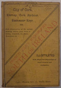
Illustrated Handbook City of Cork, Blarney, Cork Harbour, Blackwater River,
by GUY Francis
- Used
- good
- Paperback
- Condition
- Used - Good
- Binding
- Paperback
- Quantity Available
- 1
- Seller
-
Llandudno, Conwy, United Kingdom
- Item Price
-
£95.00£30.00 shipping to USA
Show Details
Description:
Cork: 70, Patrick Street.: Francis Guy. Soft cover. Good. Good, c1887, 7 illustrations. In rather grubby soft yellow cloth, printed in yellow & black, corners & edges worn. Spine, no title, torn at base. Internally, adverts to eps, (ii-viii), 1 map (large folding with short tear), frontis, [9], 10-88 pp, [2] adverts, 1 map, 7 illustrations (full page), 27 illustrations (within text), not dated but per WorldCat 1887, includes the tipped in pink advert between (iv & v), ink ownership name at head of cover (June 1887). Part of the Francis Guy's Handbooks, South of Ireland, No 1. Title continues: With concise itineraries of the Railway Routes from Cork to Dublin, Limerick, County Clare, Waterford, etc.
Item Price
£95.00
£30.00
shipping to USA

Didn’t find what you’re looking for?
Try adding this search to your want list. Millions of books are added to our site everyday and when we find one that matches your search, we’ll send you an email. Best of all, it’s free.
Add to Want List

Are you a frequent reader or book collector?
Join the Bibliophile's Club and save 10% on every purchase, every day — up to $20 savings per order!

Social Responsibility
Did you know that since 2004, Biblio has used its profits to build 16 public libraries in rural villages of South America?
