Description:
Paris: Ganeau, 1744. Excellent condition, strong impression, b&w engraved copperplate from Tome III of the 4to, 1744 edition of Charlevoix's "Histoire de la Nouvelle France" (Journal D'un Voyage...). The image is 9.5 x 14.5 inches, with folds as issued. This image has the full eastern USA, including Louisiane, north to Newfoundland, most of the Great Lakes, teh Atlantic Ocean, Acores, and east to the western coasts of Africa, Spain, France and British Isles. It is quite attractive, and not often seen for sale in this early state..
A New And Correct Plan Of London, Westminster And Southwark, With Several Additional Improvements Not In Any Former Survey by Dodsley, Robert - c. 1761
by Dodsley, Robert

A New And Correct Plan Of London, Westminster And Southwark, With Several Additional Improvements Not In Any Former Survey
by Dodsley, Robert
- Used
Copper engraved map. 13-1/2" x 26"- 34.2 x 66 cm. Closed tear lower right, right margin trimmed close, a few short tears and light spots in margins but otherwise in very good condition.
A comprehensive map of London extending from the Kings Road to White Chapel showing roads, streets laneways, public buildings, gardens and fields.
Howgego 118
-
Seller
Webster's Fine Books & Maps, ABAC, ILAB
 (CA)
(CA)
- Book Condition Used - Closed tear lower right, right margin trimmed close otherwise in very good condition.
- Quantity Available 1
- Publisher Published in 'London and its Environs Described' by Robert and James Dodsley,
- Place of Publication London:
- Date Published c. 1761
- Keywords Map, London, folding map, cartography

(Map of Eastern America and Atlantic Ocean): Carte De L'Ocean Occidental et Partie De L'Amerique Septentrionale..Charlevoix..fait En 1720
by Bellin, Jacques Nicolas
- Used
- Condition
- Used
- Binding
- Unknown
- Quantity Available
- 1
- Seller
-
Crozet, Virginia, United States
- Item Price
-
£392.61
Show Details
Item Price
£392.61
![A Geographicall [sic. Geographical ] Description Of All The Countries In The Known World. RARE...](https://d3525k1ryd2155.cloudfront.net/h/705/080/1090080705.0.m.jpg)
More Photos
A Geographicall [sic. Geographical ] Description Of All The Countries In The Known World. RARE 1657 geography
by Clarke, Samuel
- Used
- good
- Hardcover
- first
- Condition
- Used - Good
- Jacket Condition
- No Jacket
- Edition
- 1st Edition
- Binding
- Hardcover
- Quantity Available
- 1
- Seller
-
Portland, Oregon, United States
- Item Price
-
£688.08
Show Details
Description:
London: Thomas Newberry, 1657. 1st Edition . Hardcover. Good/No Jacket. 1657 FIRST EDITION, no illustrations, no maps, 278mm tall (covers), 272mm tall (pages). Full title: A Geographical Description Of All The Countries In The Known World. As Also Of the greatest and famousest Cities and Fabricks which have been, or are now remaining: Together with The greatest Rivers, the Strangest Fountains, the various Minerals, Stones, Trees, Hearbs, Plants, Fruits, Gums, &c. which are to bee found in every Country. Unto which is added, a Description of The rarest Beasts, Fowls, Birds, Fishes, and Serpents which are least known amongst us. Collected out of the most approved Authors, and from such as were eye-witnesses of most of the things contained herein. Vellum boards with calf title patch on spine lettered in gilt. Title page + 225 pages + 6 unnumbered pages of index + 7 pages of manuscript index. Soiled covers, some flaking on rear cover, solid binding, occasional page soiling but nothing major, wrinkle to…
Read More Item Price
£688.08
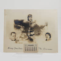
Calendar for 1936 depicting pilot Martie Bowman in her WACO INF biplane, and her daughter Larnie Bowman Allen.
by Bowman, Martie
- Used
- Condition
- Used
- Binding
- Unknown
- Quantity Available
- 1
- Seller
-
Moray, United Kingdom
- Item Price
-
£450.00
Show Details
Description:
[Olympia, WA], 1935. Silver gelatin composite photograph (250 x 200 mm) with small tear-off monthly calendar for 1936. Inscribed "Merry Christmas, The Bowmans". A few minor nicks and spots at the edges. Excellent, unused condition. A remarkable piece of early aviation ephemera, this calendar was produced as a Christmas greeting by the early female aviator Marguerite (Martie) Bowman (1901-1985) and her husband Leslie, also a pilot. It depicts Bowman flying in her WACO INF biplane, registration number NC625Y, in formation with two others, and includes portraits of Bowman, her husband, and their daughter Larnie Bowman Allen. We have learned from one of the Bowmans' grandchildren that Larnie joined the family profession, becoming a wing-walker at eight and soloing at twelve. The Bowmans established an aviation business together and, during the 1920s, 30s and 40s, Martie Bowman ferried planes from factories and regularly participated in air races. She competed in the 1930 Women's Dixie Air Derby from…
Read More Item Price
£450.00

More Photos
MEXICO ILLUSTRATED WITH DESCRIPTIVE LETTER-PRESS IN ENGLISH AND SPANISH
by Philips, John
- Used
- near fine
- Hardcover
- Condition
- Used - Near Fine
- Edition
- 1st Facsimile Edition
- Binding
- Hardcover
- Quantity Available
- 1
- Seller
-
Salisbury, Connecticut, United States
- Item Price
-
£505.94
Show Details
Description:
Manuel Quesada Brfandi, 1964. 1st Facsimile Edition. Hardcover. Near Fine. Facsimile of 1848 edition, folio, full tan leather gilt-ruled and titles stamped in brown front cover and spine. #306 of 1000 copies. The original edition published in 1848 by E. Atchley, Library of Fine Arts, London. 26 plates each with polished tissue guard, the original lithographs by Messrs Rider and Walker from drawings by John Phillips and printed by Day & Son, lithographer to the Queen. Minor scuffing to corners and spine tips, internals as new. A superior copy.
Item Price
£505.94
More Photos
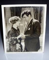
Babe Comes Home (Vintage Babe Ruth Photograph) with Movie Company Info
by Ruth, Babe and Anna Q. Nilsson
- Used
- Condition
- Used
- Binding
- Unknown
- Quantity Available
- 1
- Seller
-
Scottsdale, Arizona, United States
- Item Price
-
£424.99
Show Details
Description:
1927. An 8" x 10" vintage movie photograph of Babe Ruth and his co-star Anna Q. Nilsson in the now lost film "Babe Comes Home". The photograph has attached the information from the Movie Company First National Pictures, Inc. with a short summary of the story. First National found this film was a huge hit at the box office. It was filmed at the Los Angeles Wrigley Field (then a minor league stadium) owned by William K. Wrigley and later films made there included The Pride of the Yankees, The Stratton Story, and Damn Yankees. The film was made in the spring of 1927 with co-star Anna Quirentia Nilsson who also was the first Swedish actress to receive her own star on the Hollywood Walk of Fame. What makes this especially scarce is the attached label which gives added provenance to a very rare Babe Ruth photograph.
Item Price
£424.99

(Map / Chart- Environs of Vienna, Austria): Plan de la Ville De Vienne en Austriche et Ses Environs
by Jaillot, Alexis-Hubert
- Used
- Condition
- Used
- Binding
- Unknown
- Quantity Available
- 1
- Seller
-
Crozet, Virginia, United States
- Item Price
-
£481.65
Show Details
Description:
Paris: Jaillot, 1695. VG, with only flaw some dampstaining at lower margin with expert verso paper reinforcement, not affecting main image (would mat well). Centerfold as issued; hand-colored. A very uncommon and attractive plate, with a small walled city view (birds-eye) of Vienna, with all surrounding villages (castles) marked. A nice image of the Danube is central here. Jaillot was originally a sculptor (see Moreland & Bannister: Antique Maps). The copperplate image is 18x25.5 inches. .
Item Price
£481.65
More Photos
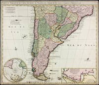
Carte du Paraguay, du Chili, Détroit de Magellan, & Terre de Feu, dans l'Amerique Meridionale par la veuve de Nicholas Visscher
by Visscher, Nicolas
- Used
- Condition
- Used - Margins trimmed but still quite ample, some small marginal stains, a handsome copy.
- Binding
- Unknown
- Quantity Available
- 1
- Seller
-
East Jewett, New York, United States
- Item Price
-
£607.12
Show Details
Description:
Amsterdam: Widow of Visscher, 1710. Single sheet copper engraved map, hand-colored. Margins trimmed but still quite ample, some small marginal stains, a handsome copy.. 515 x 595 mm. Strong image of the southern half of South America. Two insets: Carte particuliere de Detroit de Magellan and Circulus Antarcticus. Includes routes of the 18th c. explorers. Rodrigues 2556. Medina: Mapoteca Chilena, p.31, 10a (1740 ed).
Item Price
£607.12
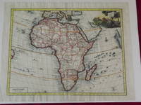
Carta Genererale dell' África.
by Delisle, Guillaume.
- Used
- Condition
- Used
- Quantity Available
- 1
- Seller
-
Florham Park, New Jersey, United States
- Item Price
-
£688.08
Show Details
Description:
Double-page hand colored engraved map, 350 x 445 mm (18" x 14", decorative cartouche. Coloring likely done at a later date, but attractively applied, wide margins, very minor aging; a bright and clear impression. Guillaume Delisle (1675-1726) was a French cartographer who was considered one of the best of his age. He has even been referred to as the father of modern geography, and was appointed Premier Geographer to Louis XV in 1718. According to Tooley and Bricker his 1700 map of Africa added a level of accuracy that would hold value for decades to come. This map of Africa is map number 84 in Norwich's Maps of Africa. The coloring was probably done at a later date, but there is an attractive cartouche with several figures, including a man spearing a crocodile. The map is from an Italian edition of Delisle’s Atlante Novissimo. Tooley & Bricker: Landmarks of Mapmaking. Norwich # 84.
Item Price
£688.08

More Photos
Geology of California: Geological Survey of California, Volume 1, Geology, Report of Progress and Synopsis of the Field Work From 1860 to 1864
by J.C. Whitney
- Used
- Hardcover
- first
- Condition
- Used
- Binding
- Hardcover
- Quantity Available
- 1
- Seller
-
Davis, California, United States
- Item Price
-
£505.94
Show Details
Description:
ORIGINAL 1865 First Edition, 498pp. Report on the first systematic survey of the geology of the state of California. Historic document suitable for a library archive, bespoke gift, or investment.This classic work presents the results of the comprehensive investigations of California geology. Clarence King was a member of the Geologic Corps under Whitney's direction as State Geologist. The full-page woodcut plates show scenery in the Sierras and Yosemite. The plates were made from drawings by Whitney and C. F. Hoffman, and from Yosemite photographs by Carleton Watkins. The Yosemite illustrations are some of the earliest published views of the future National Park. Chap. 1: Introduction.Chap. 2: The Monte Diablo Range.Chap. 3: The Peninsula of San Francisco.Chap. 4: The Coast Ranges North.Chap. 5: The Coast Ranges South.Chap. 6: The Coast Ranges from the Vicinity of Los Angeles South.Chap. 7: The Region between Cañada de Las Uvas and Soledad Pass..PART II: Geology of the Sierra Nevada.Chap.…
Read More Item Price
£505.94

Published by the Milwaukee Sentinel Commemorating Its One Hundredth Anniversary June 27, 1937: Approved by the Wisconsin Conservation Commission, Checked and Approved by Dr. Joseph Schafer, Superintendent of the Historical Society of Wisconsin and Dr. Louise Phelps Kellogg, Senior Research Associate Endorsed by the Wisconsin State Chamber of Commer
by Copyright 1932 by Erwin F. Bahlmann and Artist Nina S. Bahlman
- Used
- Condition
- Used
- Quantity Available
- 1
- Seller
-
FRAMINGHAM, Massachusetts, United States
- Item Price
-
£526.18
Show Details
Description:
Map Details and Condition:color lithograph by Litho in U.S.A.
dimensions: 24" x 28.5 " print, 26 1/4" x 30" sheet size
condition: professionally removed from wood backing and restored, deeply toned paper, some surface damage to paper, repaired vertical tear through sheet, backed with Japanese Mulberry tissue, some chipping at edges Map Description:
This scarce Wisconsin pictorial map was created by the artist Nina S. Bahlman (b1886-___) whose art work other than this map may exist in collections but is not readily identified. The copyright is held by Erwin F. Bahlmann (b.1886-__) a family member or spouse. The Library of Congress cites its copy of this map as Historical Map of Wisconsin and cites a 1995 copyright registration. WorldCat confirms that there is a 1995 reprint of this map. A further note corrects the spelling of the artist's name to read "Bahlmann". The example of the map on offer gives every appearance of being the 1932 edition.
The map was published… Read More
Item Price
£526.18

The Economy Of Human Life: 21st Century Revision
by Dodsley, Mr Robert; Penny, Mr Ed
- Used
- very good
- Paperback
- Condition
- Used - Very Good
- Binding
- Paperback
- ISBN 10 / ISBN 13
- 9781074421199 / 1074421191
- Quantity Available
- 1
- Seller
-
Seattle, Washington, United States
- Item Price
-
£12.05
Show Details
Description:
Independently published, 2019. Paperback. Very Good. May have limited writing in cover pages. Pages are unmarked. ~ ThriftBooks: Read More, Spend Less.Dust jacket quality is not guaranteed.
Item Price
£12.05
The Economy of Human Life
by Robert Dodsley
- Used
- Hardcover
- Condition
- Used - Collectible - Acceptable
- Binding
- Hardcover
- Quantity Available
- 1
- Seller
-
Frederick, Maryland, United States
- Item Price
-
£9.28
Show Details
Description:
Suttaby, B. Crosby, and Scatchard and Letterman and C. Corrall. Collectible - Acceptable. London: W. Suttaby, B. Crosby, and Scatchard and Letterman and C. Corrall, 1808. 32mo Hardcover 84 pgs. Illustrated frontis. Fair. Front cover loose. Foxed. Inquire if you need further information.
Item Price
£9.28
The Toy Shop 1735: The King and the Millerof Mansfield 1737
by Robert Dodsley
- Used
- Paperback
- Condition
- Used - VG/no dust jacket
- Binding
- Paperback
- Quantity Available
- 1
- Seller
-
Roseville, Minnesota, United States
- Item Price
-
£9.71
Show Details
Description:
William Andrews Clark Memorial Library,, 1983. VG/no dust jacket. Paperback,NO highlighting or notes, has normal slight edge wear to corners and edges; otherwise, a tight, clean copy.
Item Price
£9.71
A Select Collection of Old English Plays, Volume 01
by Dodsley, Robert [Compiler]
- Used
- Condition
- Used
- Quantity Available
- 999
- Seller
-
Torrance, California, United States
- Item Price
-
£12.13
Show Details
Description:
MP3 Audio CD. 14.99 by Dodsley, Robert, 1703-1764 [Compiler]; Hazlitt, William Carew, 1834-1913 [Editor]"Rediscover This Timeless Classic - The Ultimate MP3 Audiobook CD Experience!"
Journey back in time and immerse yourself in a world of timeless stories with our classic MP3 Audiobook series. Evoke the magic of yesteryears and let the narratives from eras gone by captivate your senses.
📚 Why Dive into Our Classic Title MP3 Audiobook CDS?
Historical Significance: Journey back in time with this masterwork, which has shaped literature, inspired countless adaptations, and touched the hearts of generations.
Authentic Reproduction: Faithfully reproduced to capture the essence of the original publication.
High Quality Narration: Relish the richness of an advanced AI voice that brings alive the written tales and captures the essence of the classic era.
Consistent Quality:AI narration ensures a consistent tone and pace throughout the book. There's no risk of the narrator becoming fatigued or any… Read More
Item Price
£12.13
A Select Collection of Old English Plays, Volume 08
by Dodsley, Robert [Compiler]
- Used
- Condition
- Used
- Quantity Available
- 999
- Seller
-
Torrance, California, United States
- Item Price
-
£12.13
Show Details
Description:
MP3 Audio CD. 14.99 by Dodsley, Robert, 1703-1764 [Compiler]; Hazlitt, William Carew, 1834-1913 [Editor]"Rediscover This Timeless Classic - The Ultimate MP3 Audiobook CD Experience!"
Journey back in time and immerse yourself in a world of timeless stories with our classic MP3 Audiobook series. Evoke the magic of yesteryears and let the narratives from eras gone by captivate your senses.
📚 Why Dive into Our Classic Title MP3 Audiobook CDS?
Historical Significance: Journey back in time with this masterwork, which has shaped literature, inspired countless adaptations, and touched the hearts of generations.
Authentic Reproduction: Faithfully reproduced to capture the essence of the original publication.
High Quality Narration: Relish the richness of an advanced AI voice that brings alive the written tales and captures the essence of the classic era.
Consistent Quality:AI narration ensures a consistent tone and pace throughout the book. There's no risk of the narrator becoming fatigued or any… Read More
Item Price
£12.13
A Select Collection of Old English Plays, Volume 02
by Dodsley, Robert [Compiler]
- Used
- Condition
- Used
- Quantity Available
- 999
- Seller
-
Torrance, California, United States
- Item Price
-
£12.13
Show Details
Description:
MP3 Audio CD. 14.99 by Dodsley, Robert, 1703-1764 [Compiler]; Hazlitt, William Carew, 1834-1913 [Editor]"Rediscover This Timeless Classic - The Ultimate MP3 Audiobook CD Experience!"
Journey back in time and immerse yourself in a world of timeless stories with our classic MP3 Audiobook series. Evoke the magic of yesteryears and let the narratives from eras gone by captivate your senses.
📚 Why Dive into Our Classic Title MP3 Audiobook CDS?
Historical Significance: Journey back in time with this masterwork, which has shaped literature, inspired countless adaptations, and touched the hearts of generations.
Authentic Reproduction: Faithfully reproduced to capture the essence of the original publication.
High Quality Narration: Relish the richness of an advanced AI voice that brings alive the written tales and captures the essence of the classic era.
Consistent Quality:AI narration ensures a consistent tone and pace throughout the book. There's no risk of the narrator becoming fatigued or any… Read More
Item Price
£12.13
A Select Collection of Old English Plays, Volume 06
by Dodsley, Robert [Compiler]
- Used
- Condition
- Used
- Quantity Available
- 999
- Seller
-
Torrance, California, United States
- Item Price
-
£12.13
Show Details
Description:
MP3 Audio CD. 14.99 by Dodsley, Robert, 1703-1764 [Compiler]; Hazlitt, William Carew, 1834-1913 [Editor]"Rediscover This Timeless Classic - The Ultimate MP3 Audiobook CD Experience!"
Journey back in time and immerse yourself in a world of timeless stories with our classic MP3 Audiobook series. Evoke the magic of yesteryears and let the narratives from eras gone by captivate your senses.
📚 Why Dive into Our Classic Title MP3 Audiobook CDS?
Historical Significance: Journey back in time with this masterwork, which has shaped literature, inspired countless adaptations, and touched the hearts of generations.
Authentic Reproduction: Faithfully reproduced to capture the essence of the original publication.
High Quality Narration: Relish the richness of an advanced AI voice that brings alive the written tales and captures the essence of the classic era.
Consistent Quality:AI narration ensures a consistent tone and pace throughout the book. There's no risk of the narrator becoming fatigued or any… Read More
Item Price
£12.13
A Select Collection of Old English Plays, Volume 09
by Dodsley, Robert [Compiler]
- Used
- Condition
- Used
- Quantity Available
- 999
- Seller
-
Torrance, California, United States
- Item Price
-
£12.13
Show Details
Description:
MP3 Audio CD. 14.99 by Dodsley, Robert, 1703-1764 [Compiler]; Hazlitt, William Carew, 1834-1913 [Editor]"Rediscover This Timeless Classic - The Ultimate MP3 Audiobook CD Experience!"
Journey back in time and immerse yourself in a world of timeless stories with our classic MP3 Audiobook series. Evoke the magic of yesteryears and let the narratives from eras gone by captivate your senses.
📚 Why Dive into Our Classic Title MP3 Audiobook CDS?
Historical Significance: Journey back in time with this masterwork, which has shaped literature, inspired countless adaptations, and touched the hearts of generations.
Authentic Reproduction: Faithfully reproduced to capture the essence of the original publication.
High Quality Narration: Relish the richness of an advanced AI voice that brings alive the written tales and captures the essence of the classic era.
Consistent Quality:AI narration ensures a consistent tone and pace throughout the book. There's no risk of the narrator becoming fatigued or any… Read More
Item Price
£12.13
A Select Collection of Old English Plays, Volume 14
by Dodsley, Robert [Compiler]
- Used
- Condition
- Used
- Quantity Available
- 999
- Seller
-
Torrance, California, United States
- Item Price
-
£12.13
Show Details
Description:
MP3 Audio CD. 14.99 by Dodsley, Robert, 1703-1764 [Compiler]; Hazlitt, William Carew, 1834-1913 [Editor]"Rediscover This Timeless Classic - The Ultimate MP3 Audiobook CD Experience!"
Journey back in time and immerse yourself in a world of timeless stories with our classic MP3 Audiobook series. Evoke the magic of yesteryears and let the narratives from eras gone by captivate your senses.
📚 Why Dive into Our Classic Title MP3 Audiobook CDS?
Historical Significance: Journey back in time with this masterwork, which has shaped literature, inspired countless adaptations, and touched the hearts of generations.
Authentic Reproduction: Faithfully reproduced to capture the essence of the original publication.
High Quality Narration: Relish the richness of an advanced AI voice that brings alive the written tales and captures the essence of the classic era.
Consistent Quality:AI narration ensures a consistent tone and pace throughout the book. There's no risk of the narrator becoming fatigued or any… Read More
Item Price
£12.13
A Select Collection of Old English Plays, Volume 07
by Dodsley, Robert [Compiler]
- Used
- Condition
- Used
- Quantity Available
- 999
- Seller
-
Torrance, California, United States
- Item Price
-
£12.13
Show Details
Description:
MP3 Audio CD. 14.99 by Dodsley, Robert, 1703-1764 [Compiler]"Rediscover This Timeless Classic - The Ultimate MP3 Audiobook CD Experience!"
Journey back in time and immerse yourself in a world of timeless stories with our classic MP3 Audiobook series. Evoke the magic of yesteryears and let the narratives from eras gone by captivate your senses.
📚 Why Dive into Our Classic Title MP3 Audiobook CDS?
Historical Significance: Journey back in time with this masterwork, which has shaped literature, inspired countless adaptations, and touched the hearts of generations.
Authentic Reproduction: Faithfully reproduced to capture the essence of the original publication.
High Quality Narration: Relish the richness of an advanced AI voice that brings alive the written tales and captures the essence of the classic era.
Consistent Quality:AI narration ensures a consistent tone and pace throughout the book. There's no risk of the narrator becoming fatigued or any variations happening in the audio quality.… Read More
Item Price
£12.13

More Photos
The Sky and the Forest
by Forester, C.S
- Used
- very good
- Hardcover
- first
- Condition
- Used - Very Good
- Jacket Condition
- Very Good
- Edition
- First Edition
- Binding
- Hardcover
- Quantity Available
- 1
- Seller
-
Salem, Oregon, United States
- Item Price
-
£28.24£16.94Save £13.96!
Show Details
Description:
C.S. Forester: The Sky and the Forest. Little, Brown and Company, Boston. Stated First Edition First Printing Thus August, 1948. Cover price $2.75. Used. VG BOOK/VG UNCLIPPED DUST JACKET. A story of a central Africa. By C.S. Forester, author of the Admiral Hornblower series.
Item Price
£28.24£16.94
Save £13.96
!
![Alaska and Klondike Region; [With inset of Klondike Region on the Upper Yukon detail] [From an...](https://d3525k1ryd2155.cloudfront.net/h/062/537/1339537062.0.m.jpg)
Alaska and Klondike Region; [With inset of Klondike Region on the Upper Yukon detail] [From an atlas, "Gazetteer of Alaska and Yukon Region " pp. 105 and 106]
by Miller, J. Martin
- Used
- very good
- Condition
- Used - Very Good
- Edition
- Unknown
- Quantity Available
- 1
- Seller
-
Sebastopol, California, United States
- Item Price
-
£31.57
Show Details
Description:
Chicago: J. Martin Miller, 1899. Unknown. Map. Very Good. [Map copyright 1899, printing date of Atlas later] [19.875x15.125in]; Colored map of Alaska with steamer routes from Portland and Seattle, insets of the Klondike Region on the Upper Yukon and Western portion of Aleutian Islands; On verso index of places and names with two large black and white images; Age toning to all edges, water stain marks on bottom, slight printing offset of colors, small chips and closed tears to lower edge;.
Item Price
£31.57

Zemepis Sveta - Monsunova Asie
by De La Blache, P. Vidal; Gallois, L
- Used
- Hardcover
- Condition
- Used - Very Good Condition
- Jacket Condition
- No Dust Jacket
- Binding
- Hardcover
- Quantity Available
- 1
- Seller
-
Oak Point, Texas, United States
- Item Price
-
£48.57
Show Details
Description:
Aventinum, Prague, Czechoslovakia, 1931. Hardcover. Very Good Condition/No Dust Jacket. Text entirely in Czech. Geography book on Asia with numerous photographs and maps. 1930 edition also available. Size: 4mo - over 9 3/4" - 12" tall. 400 pp. Pages are yellowed, but are tight and clean. Moderate shelfwear along the spine. Corners are lightly bumped. Quantity Available: 1. Shipped Weight: 3-5 pounds. Category: Travel & Places; Non-English Language::Czech; Pictures of this item not already displayed here available upon request. Inventory No: 001228. . Additional shipping charges may apply.
Item Price
£48.57

Zemepis Sveta - Monsunova Asie
by De La Blache, P. Vidal; Gallois, L
- Used
- Hardcover
- Condition
- Used - Very Good Condition
- Jacket Condition
- No Dust Jacket
- Binding
- Hardcover
- Quantity Available
- 1
- Seller
-
Oak Point, Texas, United States
- Item Price
-
£48.57
Show Details
Description:
Aventinum, Prague, Czechoslovakia, 1930. Hardcover. Very Good Condition/No Dust Jacket. Text entirely in Czech. Geography book on Asia with numerous photographs and maps. 1931 edition also available. Size: 4mo - over 9 3/4" - 12" tall. 400 pp. Pages are yellowed, but are tight and clean. Moderate shelfwear along the spine. Corners are lightly bumped. Quantity Available: 1. Shipped Weight: 3-5 pounds. Category: Travel & Places; Non-English Language::Czech; Pictures of this item not already displayed here available upon request. Inventory No: 001227. . Additional shipping charges may apply.
Item Price
£48.57

North America from the Best Authorities, Russell, ca.1800
by Russell
- Used
- Condition
- Used
- Quantity Available
- 1
- Seller
-
Plymouth, Devon, United Kingdom
- Item Price
-
£20.00
Show Details
Description:
Russell, J. : A General Map of North America from the Best Authorities. Nd but ca.1800. From "A New Geographical, Historical and Commercial Grammar and Present State of Several Kingdoms of the World." Copper engraving. Size approx 200 x 230mm. Two neat folds. Some age colouring to edges, otherwise very clean and bright.
Item Price
£20.00

Asia from the Best Authorities, Russell, ca.1800
by Russell
- Used
- Condition
- Used
- Quantity Available
- 1
- Seller
-
Plymouth, Devon, United Kingdom
- Item Price
-
£20.00
Show Details
Description:
Russell, J. : Asia from the Best Authorities. Nd but ca.1800. From "A New Geographical, Historical and Commercial Grammar and Present State of Several Kingdoms of the World". Copper engraving. Size approx 200 x 230mm. Two neat folds. Some age colouring to edges, otherwise clean and bright. Includes Arabia, India, Borneo, Japan, China and eastern Russia.
Item Price
£20.00
![MAP OF UTAH [Territory]](https://d3525k1ryd2155.cloudfront.net/h/836/461/1485461836.0.m.jpg)
More Photos
MAP OF UTAH [Territory]
- Used
- Condition
- Used - Very Good-
- Edition
- Original
- Quantity Available
- 1
- Seller
-
Williamsburg, Virginia, United States
- Item Price
-
£52.62
Show Details
Description:
New York, Richmond, Chicago, & Toledo: H. H. Hardesty, 1885. Original color lithographed map printed by Rand, McNally & Company, Engravers and published in HARDESTY'S HISTORICAL AND GEOGRAPHICAL ENCYCLOPEDIA: SPECIAL VIRGINIA EDITION. 19 3/8 inches by 13 1/4 inches on a 21" X 14 1/2" sheet. The map depicts the Territory of Utah in its final form--large areas had been removed and ceded to Nevada, Colorado, Wyoming, and Nebraska since Utah became a U. S. Territory in 1850. The issue of polygamy prevented statehood until it was finally granted in 1896. This map features railroads and topography and uses color to set off counties from each other. Unlike most atlas maps of the period, this map identifies most small towns. The map is guaranteed to be moe than 135 years old. The map is in about very good condition: generally clean and bright, with slight toning of paper and one faint water stain near the center-left edge of the map.. Original. Single Sheet. Very Good-. Elephant…
Read More Item Price
£52.62

Philips Special Map of the Nile, The Advance on Khartum and the Environs of Omdurman. Cc1900
by George Philips and Son,
- Used
- Condition
- Used
- Quantity Available
- 1
- Seller
-
Plymouth, Devon, United Kingdom
- Item Price
-
£26.00
Show Details
Description:
Philips Special map of the Nile illustrating the Advance on Khartum [Khartoum] with an enlargement of the environs of Omdurman [Omdur]. George Philips and Son, London and Liverpool Ca 1900. 580mm x 900mm folded map. Front title wrapper has come loose, not affecting map area. Three maps are displayed within the sheet. Map1. Map of the Nile Valley 520mm x 300mm showing the approaches of Khartum. Scale 1inch to 100 Geographical miles. Coloured indicating Possessions and Protectorates of European Powers. Map 2. Special map of the Nile from Dongola to Khartum. Scale 16 miles to the inch. Coloured. In set in this map is Map3. Environs of Omdurman, Scale 5 statute miles to the inch. Some small breaks at some folds, not affecting imagery or use of map. Title label is damaged, the map is clean and bright, probably unused. A very interesting record.
Item Price
£26.00

Last Tales
by Dinesen, Isak
- Used
- very good
- Hardcover
- first
- Condition
- Used - Very Good
- Jacket Condition
- Good+
- Edition
- First Edition
- Binding
- Hardcover
- Quantity Available
- 1
- Seller
-
Salem, Oregon, United States
- Item Price
-
£97.14£58.28Save £48.00!
Show Details
Description:
Dinesen, Isak: Last Tales, A Collection of Twelve New Tales of Compelling Beauty 1957, Random House. First Edition. Stated First Printing Thus. Used. Very Good/Good+ original red dust jacket, price-clipped. Jacket states 11/57 on front flap. 5 3/4 X
Item Price
£97.14£58.28
Save £48.00
!

The Adventure of Wrangel Island
by Vilhjalmur Stefansson
- Used
- good
- Hardcover
- first
- Condition
- Used - Good
- Jacket Condition
- No DJ Included
- Edition
- First Edition
- Binding
- Hardcover
- Quantity Available
- 1
- Seller
-
Salem, Oregon, United States
- Item Price
-
£101.10£60.66Save £49.96!
Show Details
Description:
The Adventure of Wrangel Island, Alaska (1925 Macmillan 1st Edition) HISTORY OF ALASKA. EXLIB. Good Condition/ No DJ included. Fold-out map affixed to binding at the back of the book has never been opened. The story of the (unsuccessful) attempted colonization of Wrangel Island Alaska. 413 pages plus appendix, Index. Titling is still bright. A clean, solid copy. Scarce.
Item Price
£101.10£60.66
Save £49.96
!
