Maps from Daniel Crouch Rare Books Ltd
New Arrivals

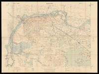
A New Geological Map of England and Wales,
by SMITH, William
- Condition
- Used
- Published
- March 18th, 1820.
- Quantity Available
- 1
- Seller
-
London, GBR
- Item Price
-
£15,000.00
Show Details
Description:
London,: Published by J. Cary, 86 St James's Str., March 18th, 1820.. 780 by 645mm. (30.75 by 25.5 inches).. Engraved map, fine original hand colour, dissected and mounted on linen, two small stains near the Thames Estuary, folding into original green marbled paper slipcase, publisher's label pasted to upper board, rubbed. Rare reduction of William Smith's seminal geological map;… Read more about this item Item Price
£15,000.00
![To The Hon[oura]ble the Court Directors of the East India Company This Improved Map of India](https://d3525k1ryd2155.cloudfront.net/h/913/468/1286468913.0.m.jpg)
To The Hon[oura]ble the Court Directors of the East India Company This Improved Map of India
by ARROWSMITH, Aaron
- Condition
- Used
- Published
- 2nd January, 1816.
- Quantity Available
- 1
- Seller
-
London, GBR
- Item Price
-
£10,000.00
Show Details
Description:
London,: Published by A. Arrowsmith, Hydrographer to his Majesty, No. 10 Soho Square,, 2nd January, 1816.. 2400 by 2670mm (94.5 by 105 inches).. Large engraved map, on nine sheets, original outline hand-colour, some off-setting. Arrowsmith's monumental wall map of India on nine sheets. With the growing influence of the British in India at the end of the eighteenth… Read more about this item Item Price
£10,000.00

World on Mercator's Projection, Shewing the Distribution of Gold.
by WYLD, James
- Condition
- Used
- Published
- [c1851].
- Quantity Available
- 1
- Seller
-
London, GBR
- Item Price
-
£2,500.00
Show Details
Description:
London,: James Wyld, Geographer to the Queen & H.R.H. Prince Albert. Model of the Earth Leicester Square,, [c1851].. 340 by 525mm. (13.5 by 20.75 inches).. Lithographed pocket map folding into publisher's green cloth wallet, with circular printed paper label on both covers, uncoloured One of five maps issued with Wyld's very rare 'Gold Fields of Australia', also 1851,… Read more about this item Item Price
£2,500.00

Hong Kong surveyed by Capt. Sir Edward Belcher.
by BELCHER, Captain
- Condition
- Used
- Published
- May 1st, 1843 - Corrected to 184
- Quantity Available
- 1
- Seller
-
London, GBR
- Item Price
-
£20,000.00
Show Details
Description:
London,: Hydrographic Office of the Admiralty,, May 1st, 1843 - Corrected to 1846.. 700 by 1020mm (27.5 by 40.25 inches).. Engraved chart The British Hydrographic Office was founded in 1795 by George III, who appointed Alexander Dalrymple as the first Hydrographer to the Admiralty. The first charts were produced in 1800. Unlike the U. S. Coast Survey, the… Read more about this item Item Price
£20,000.00
Map of Nanking
by War Office, Geographical Section, General Staff
- Condition
- Used
- Published
- 1927.
- Quantity Available
- 1
- Seller
-
London, GBR
- Item Price
-
£3,500.00
Show Details
Description:
War Office, Geographical Section, General Staff, 1927.. 745 by 995mm. (29.25 by 39.25 inches).. Coloured lithograph map dissected into 32 (4 by 8) sections mounted on linen. Scale 1:250,000 Nanking in 1927 was a treaty port located on the southern shores of the Yangtze River. Because the foreign interests in China were largely American and European, squadrons of… Read more about this item Item Price
£3,500.00
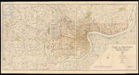
Map of Shanghai
by [Anonymous]
- Condition
- Used
- Published
- 1st June 1913.
- Quantity Available
- 1
- Seller
-
London, GBR
- Item Price
-
£20,000.00
Show Details
Description:
Shanghai,: North-China Daily News & Herald Limited,, 1st June 1913.. 735 by 1510mm. (29 by 59.5 inches).. A large English map of Shanghai, dissected in 40 (4 by 10) sections and mounted on linen, folding map. Oriented with north towards the upper right. Top left includes an inset of "plan shewing the rubicon road system". Signed by Engineer and… Read more about this item Item Price
£20,000.00

Map of Brooklyn and Vicinity.
by DRIPPS, Matthew
- Condition
- Used
- Published
- 1873.
- Quantity Available
- 1
- Seller
-
London, GBR
- Item Price
-
£1,200.00
Show Details
Description:
New York,: M. Dripps,, 1873.. 610 by 470mm. (24 by 18.5 inches).. Folding lithographed pocket map with contemporary hand-colour in full, tipped-in to blue cloth gilt covers, some separations and toning at old folds. Dripps' first map dedicated to Brooklyn was published in 1864. Between then and when he published the current map nearly ten years later, the third… Read more about this item Item Price
£1,200.00

A Plan of the Attack by Lord Nelson of the Combined Fleet, October 21st, 1805.
by DODD, R[obert]
- Condition
- Used
- Published
- Nov[ember], 1805.
- Quantity Available
- 1
- Seller
-
London, GBR
- Item Price
-
£3,000.00
Show Details
Description:
London,: Published by R. Dodd, marine painter, near the Admiralty,, Nov[ember], 1805.. (image) 265 by 365mm (10.5 by 14.25 inches); (sheet) 660 by 440mm (26 by 17.25 inches).. Coloured aquatint with letterpress text below, minor loss to lower right not affecting text. This rare broadside was published the month following Nelson's most famous victory. The great deciding naval… Read more about this item Item Price
£3,000.00
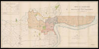
Plan of Shanghai & Environs Published Under Authority of the Municipal Council. 1933.
by [Anonymous]
- Condition
- Used
- Published
- 27th October 1932.
- Quantity Available
- 1
- Seller
-
London, GBR
- Item Price
-
£25,000.00
Show Details
Description:
Shanghai,: Shanghai Municipal Council,, 27th October 1932.. 860 by 1744mm. (33.75 by 68.75 inches).. Coloured lithograph map, dissected and laid on linen, early ownership stamp of "John Pook & Co." in blank area, folding into original cloth portfolio, lettered in gilt 'General Map of Shanghai 1933' on spine. Acknowledgement is made of information obtained from the French Municipal… Read more about this item Item Price
£25,000.00
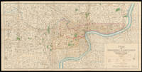
Plan of Shanghai 1928
by [Anonymous]
- Condition
- Used
- Published
- 21st April 1928.
- Quantity Available
- 1
- Seller
-
London, GBR
- Item Price
-
£20,000.00
Show Details
Description:
London,: Standford's Geog.l Establishment, London,, 21st April 1928.. 880 by 1660mm. (34.75 by 65.25 inches).. A large coloured lithographed map showing the plan of Shanghai, made in 1928. Signed by Commissioner of public works, 44 (4 by 11) sheets mounted on linen. The map depicts Shanghai city in 1928, with the French Settlements and Shanghai International… Read more about this item Item Price
£20,000.00
