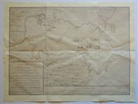
Click for full-size.
Map of Vermillion County, Indiana drawn by John Collett for the 1st annual report of Prof. E.T. Cox, State Geologist, 1869
- Used
- Paperback
- first
- Condition
- Very Good Plus
- Seller
-
Bloomington, Indiana, United States
Payment Methods Accepted
About This Item
Indianapolis: W. & J. Braden, 1869. Original map from the 1869 book, open measurement, 12 1/4" x 30", folds to 8 1/2" x 5 ", Very Good Plus, 2" tear at fold and 1/2" tear at fold, light soiling to verso at main folded section. One of 3 maps from the SCARCE 1869 book.. First Printing. Map, Folded. Very Good Plus. 12 1/4" x 30".
Reviews
(Log in or Create an Account first!)
Details
- Bookseller
- Dale Steffey Books, ABAA
 (US)
(US)
- Bookseller's Inventory #
- 009379
- Title
- Map of Vermillion County, Indiana drawn by John Collett for the 1st annual report of Prof. E.T. Cox, State Geologist, 1869
- Format/Binding
- Paperback
- Book Condition
- Used - Very Good Plus
- Edition
- First Printing
- Publisher
- W. & J. Braden
- Place of Publication
- Indianapolis
- Date Published
- 1869
- Size
- 12 1/4" x 30"
- Weight
- 0.00 lbs
- Bookseller catalogs
- Indiana History; MAPS;
Terms of Sale
Dale Steffey Books, ABAA
Any book is returnable for any reason within 10 days for a complete refund, as long as it is returned in the same condition as when received. Please notify in advance of return. I accept checks, money orders, Mastercard, Visa, and bank wire transfer.
About the Seller
Dale Steffey Books, ABAA
Biblio member since 2006
Bloomington, Indiana
About Dale Steffey Books, ABAA
Online bookseller specializing in rare and collectible books in all fields. Books bought and sold from single item to entire collection.
Glossary
Some terminology that may be used in this description includes:
- Verso
- The page bound on the left side of a book, opposite to the recto page.
Frequently asked questions
This Book’s Categories

Collecting food and drink books
Nothing quite whets the appetite for rare and collectible books like old and vintage cookbooks. Be sure to check out our cook books and food section of our rare book room.

Collectible Christmas Cards
Many of us love giving and receiving holiday cards - but did you know many of them are highly collectible? Whether signed by famous authors or just beautiful to look at, these collectible Christmas cards are sure to put a twinkle in your eye.