
Click for full-size.
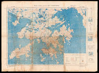
Hong Kong and the New Territories. North Sheet.: The liberation of Hong Kong from Japanese Occupation
by BRITISH WAR OFFICE
- Used
- Condition
- See description
- Seller
-
London, United Kingdom
Payment Methods Accepted
About This Item
[London], : War Office, , Aug[ust] 1945.. 780 by 1050mm. (30.75 by 41.25 inches).. Chromolithograph map with manuscript annotations in pencil and pen, with three insets and diagrams to right margin, minor browning, a few nicks and tears to margins. A unique map of Hong Kong and the New Territories, with contemporary manuscript annotations showing the liberation of Hong Kong from Japanese occupation. This map, which shows Hong Kong, Kowloon and the New Territories, was first published by the British War Office in 1936. The present example, a second edition, was published shortly after the end of the Second World War, when Britain reoccupied the islands following four years of Japanese occupation. Thick red lines across the map indicate the "all weather roads" that could be relied upon for travel and communications across the region. Extending from Lantau Island to the west to Mirs Bay in the east, from the Chinese city of Shenzhen in the north to the southern Soko Islands, it is generally considered one of the most detailed maps of Hong Kong made in the early twentieth century. The present example is made more interesting by the copious manuscript annotations that appear across the centre of the map. A grid has been drawn over Hong Kong in pencil, marking the lines of longitude and latitude more precisely. Discolouration indicates that it this lower central portion that was the primary focus of the map during its use. Annotations in pen identify features, such as "Dockyard Stores", "Canal" and "Coal Dump", and military information, including "Off[ice]rs Mess" and "2 AA Guns". There are also numerous annotations listing the number of Japanese soldiers, in Victoria these include "3000 Japs", together with a further 200 with horses, and the Japanese Officer's Mess. Japanese troop numbers are noted on Kowloon totalling just under 2000 men. More annotations can be seen further north near modern day Shenzhen, marking the location of the Head Quarters for both the Hong Kong Artillery Force, and the Defence Force, as well as military companies and infantry divisions. A note in the upper right margin identifies it as the hand of "Capt Owen[s]", an officer in the British Task Force that landed in Hong Kong on 30th August 1945, to take back control of the territory from the Japanese. Established in 1857, the British War Office was the governmental department responsible for the administration of the British Army until 1964, when its functions were transferred to the Ministry of Defense. During this time it produced many maps, with the number of publications increasing rapidly during years of conflict.
Reviews
(Log in or Create an Account first!)
Details
- Bookseller
- Daniel Crouch Rare Books Ltd
 (GB)
(GB)
- Bookseller's Inventory #
- 16008
- Title
- Hong Kong and the New Territories. North Sheet.
- Author
- BRITISH WAR OFFICE
- Book Condition
- Used
- Publisher
- War Office,
- Place of Publication
- [London],
- Date Published
- Aug[ust] 1945.
- Keywords
- Hong Kong, War Office, manuscript
- Product_type
- Maps
- Size
- 780 by 1050mm. (30.75 by 41.25 inches).
Terms of Sale
Daniel Crouch Rare Books Ltd
Any item may be returned if you are not happy with it providing we are notified within 7 days of your receiving it. This does not affect any statutory rights you may have under UK or EU law for returning the item outside this period. All we ask is that you return the item(s) by the same or similar method to that in which they were sent to you. Your postage costs and any payment already received will be refunded immediately on our receipt of the items in the same condition as you received them.
About the Seller
Daniel Crouch Rare Books Ltd
Biblio member since 2018
London
About Daniel Crouch Rare Books Ltd
Daniel Crouch Rare Books is specialist dealer in antique atlases, maps, plans, sea charts and voyages dating from the fifteenth to the nineteenth centuries. Our carefully selected stock also includes a number of fine prints and globes, and a selection of cartographic reference books.Our particular passions include rare atlases, wall maps, and separately published maps and charts. We strive to acquire unusual and quirky maps that are in fine condition. We are members of the following trade associations: The Antiquarian Bookseller's Association (ABA); The British Antique Dealers' Association (BADA); Confédération Internationale des Négociantes en Oeuvres d'Art (CINOA); The International League of Antiquarian Booksellers (ILAB); The Society of London Art Dealers (SLAD); and The European Fine Art Foundation (TEFAF). Daniel and Nick are also both members of The Company of Art Scholars, Dealers, and Collectors.
Glossary
Some terminology that may be used in this description includes:
- New
- A new book is a book previously not circulated to a buyer. Although a new book is typically free of any faults or defects, "new"...

Beat Poet Michael McClure
From the fateful reading at Six-Gallery in 1955 to his novels, poetry, and stage productions, Michael McClure was right in the thick of the Beat Generation as it was born. See his books and art and learn more about the works of Michael McClure.

Collecting The Beat Generation
The Beat Generation was born out of WWII, and it still continues to exert considerable influence on today’s literary scene. Biblio sellers have a fantastic collection of Beat Generation books and ephemera for browsing.
