
Click for full-size.
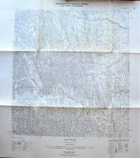
Fold-Out Topographical Survey Map. Root River, Northwest Territories
- Used
- very good
- Paperback
- Condition
- Very Good
- Seller
-
Calgary, Alberta, Canada
Payment Methods Accepted
About This Item
(Ottawa): The Army Survey Establishment/Department of National Defence., 1957 Map is scale 1: 250, 000 with lakes shaded in blue. Measures 30" by 22" with border. Shows: Roads, cart track, trails, railways, etc. Minor wear. Very Good.
Reviews
(Log in or Create an Account first!)
Details
- Bookseller
- Ken Jackson
 (CA)
(CA)
- Bookseller's Inventory #
- 256108
- Title
- Fold-Out Topographical Survey Map. Root River, Northwest Territories
- Format/Binding
- Soft cover
- Book Condition
- Used - Very Good
- Quantity Available
- 1
- Binding
- Paperback
- Publisher
- The Army Survey Establishment/Department of National Defence.
- Place of Publication
- (Ottawa)
- Date Published
- 1957
- Weight
- 0.00 lbs
- Keywords
- CARTOGRAPHY AND MAPS FOLD-OUT TOPOGRAPHICAL SURVEY MAP. ROOT RIVER, NORTHWEST TERRITORIES MAP TROUT LAKE CANADA
- Bookseller catalogs
- Cartography and Maps;
Terms of Sale
Ken Jackson
Any book may be returned for any reason. If not as described we will pay shipping both ways.
About the Seller
Ken Jackson
Biblio member since 2005
Calgary, Alberta
About Ken Jackson
We are a family business and have been involved in books since 1971.
This Book’s Categories

Collecting and identifying signed letters and holographic documents
Many authors and other famous literary figures wrote and signed letters by hand, and you can find a great collection of them in the Biblio rare book room. See our great collection of handwritten letters and holographic documents

Collecting Aleister Crowley
Aleister Crowley was a well-known and highly controversial figure in the first half of the 20th Century. A writer, occultist, magician, and mountaineer, Crowley impacted a diverse collection of sub-cultures and interests. See collectible Crowley from Biblio booksellers.
