Description:
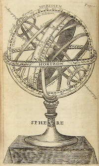
Paris: Chez l'auteur... Laurent d'Houry... Jean Boudot, libraire..., 1699. 12mo. [18],300;112 pp. plus 26 plates (three folding). Contemporary speckled calf, spine richly gilt, gilt leather label, raised bands, edges rouged. Light institutional inkstamp in title page. 18th-century inscription in titlepage and signature of Theophile Leonard in title page and final page of the dedication. Occasional 18th-century marginalia. Minor wear. Near fine. First edition of the first major work of Nicolas Bion, complete with 26 plates of terrestrial and celestial maps, diagrams, and images of globes. Bion (ca. 1652-1733) was a Paris-based cosmographer and maker of mathematical and astronomical instruments, holding the title of "king's engineer for mathematical instruments" under Louis XIV (DSB II, pp. 132-1330). A landmark in its field.
Devonshire with Excester Described by SPEED, John - 1623
by SPEED, John
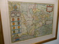
Devonshire with Excester Described
by SPEED, John
- Used
- near fine
John Sudbury & George Humble, 1623. English Text Edition. Map. Near Fine. 505 x 380mm. A early edition of Speed's map of Devon. Fabulous later full wash hand colouring. A couple of minor paper flaws add character to this wonderful map which is nearly four hundred years old. Framed and double-glazed to show text on verso, in a lovely antique gold style frame. Batten & Bennett, 6.4. [it may not be possible to post this item in it's frame].
-
Bookseller
Independent bookstores
 (GB)
(GB)
- Format/Binding Map
- Book Condition Used - Near Fine
- Quantity Available 1
- Edition English Text Edition
- Publisher John Sudbury & George Humble
- Date Published 1623
- Keywords Devon Maps.catx91, Devon. Speed Maps. Antique Maps.
- Size 505 x 380mm
More Photos
L'USAGE DES GLOBES CELESTES ET TERRESTRES, ET DES SPHERES, SUIVANT LES DIFFERENS SYSTEMES DU MONDE. PRÉCEDÉ D'UN TRAITÉ DE COSMOGRAPHIE, OÙ EST EXPLIQUÉ AVEC ORDRE TOUT CE QU'IL Y A PLUS CURIEUX DANS LA DESCRIPTION DE L'UNIVERS, SUIVANT LES MEMOIRES & OBSERVATIONS DES PLUS HABILES ASTRONOMES & GEOGRAPHES. . .
by Bion, Nicolas
- Used
- near fine
- Hardcover
- first
- Condition
- Used - Near fine
- Edition
- First Edition
- Binding
- Hardcover
- Quantity Available
- 1
- Seller
-
Brooklyn, New York, United States
- Item Price
-
£890.23
Show Details
Item Price
£890.23
![A Geographicall [sic. Geographical ] Description Of All The Countries In The Known World. RARE...](https://d3525k1ryd2155.cloudfront.net/h/705/080/1090080705.0.m.jpg)
More Photos
A Geographicall [sic. Geographical ] Description Of All The Countries In The Known World. RARE 1657 geography
by Clarke, Samuel
- Used
- good
- Hardcover
- first
- Condition
- Used - Good
- Jacket Condition
- No Jacket
- Edition
- 1st Edition
- Binding
- Hardcover
- Quantity Available
- 1
- Seller
-
Portland, Oregon, United States
- Item Price
-
£687.90
Show Details
Description:
London: Thomas Newberry, 1657. 1st Edition . Hardcover. Good/No Jacket. 1657 FIRST EDITION, no illustrations, no maps, 278mm tall (covers), 272mm tall (pages). Full title: A Geographical Description Of All The Countries In The Known World. As Also Of the greatest and famousest Cities and Fabricks which have been, or are now remaining: Together with The greatest Rivers, the Strangest Fountains, the various Minerals, Stones, Trees, Hearbs, Plants, Fruits, Gums, &c. which are to bee found in every Country. Unto which is added, a Description of The rarest Beasts, Fowls, Birds, Fishes, and Serpents which are least known amongst us. Collected out of the most approved Authors, and from such as were eye-witnesses of most of the things contained herein. Vellum boards with calf title patch on spine lettered in gilt. Title page + 225 pages + 6 unnumbered pages of index + 7 pages of manuscript index. Soiled covers, some flaking on rear cover, solid binding, occasional page soiling but nothing major, wrinkle to…
Read More Item Price
£687.90
More Photos
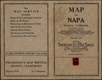
Napa County California. 1914
by Copyright 1914 by Punnett Brothers
- Used
- Condition
- Used
- Quantity Available
- 1
- Seller
-
FRAMINGHAM, Massachusetts, United States
- Item Price
-
£768.84
Show Details
Description:
Map Details and Condition:color lithograph
dimensions: 26 3/4" x 19"
Brown Paper pocket covers with red bookstore label of Neal Stratford & Kerr, San Francisco
condition: professionally flattened and otherwise in as found, very good conditionDescription:
This 1914 map of now popular wine country Napa County, California shows the county in 1914, with early roads, largely undeveloped, vast open land areas, and natural features. The numbered grid system on this map reflects the Public Land Survey System. Large open tracts of land are identified as ranches, such as Rancho Catacoula, or Rancho Las Putas, Rancho LaJota all of which are large swaths of undivided land. Urban grids are shown in the southernmost part of Napa County, and sections of the southernmost sections of Sonoma County and Solano County. The cities of Petaluma, Sonoma, Vallejo and Napa and Benicia show populated urban areas. A corner of Marin County is shown.
C.F. Weber & Co. and the Punnett Brothers published… Read More
Item Price
£768.84

More Photos
MEXICO ILLUSTRATED WITH DESCRIPTIVE LETTER-PRESS IN ENGLISH AND SPANISH
by Philips, John
- Used
- near fine
- Hardcover
- Condition
- Used - Near Fine
- Edition
- 1st Facsimile Edition
- Binding
- Hardcover
- Quantity Available
- 1
- Seller
-
Salisbury, Connecticut, United States
- Item Price
-
£505.81
Show Details
Description:
Manuel Quesada Brfandi, 1964. 1st Facsimile Edition. Hardcover. Near Fine. Facsimile of 1848 edition, folio, full tan leather gilt-ruled and titles stamped in brown front cover and spine. #306 of 1000 copies. The original edition published in 1848 by E. Atchley, Library of Fine Arts, London. 26 plates each with polished tissue guard, the original lithographs by Messrs Rider and Walker from drawings by John Phillips and printed by Day & Son, lithographer to the Queen. Minor scuffing to corners and spine tips, internals as new. A superior copy.
Item Price
£505.81

More Photos
U. S. Geographical Surveys West of the 100th Meridian: Topographical Atlas Sheets: Portfolio of Seven Maps: Colorado, New Mexico and Arizona
by George M. Wheeler
- Used
- Acceptable
- Condition
- Used - Acceptable
- Jacket Condition
- Unjacketed
- Quantity Available
- 1
- Seller
-
Cazenovia, New York, United States
- Item Price
-
£546.28
Show Details
Description:
A rare portfolio of 7 maps published by United States Government Printing Office in 1876. This copy is ex library, the portfolio quarter bound case as shown with this listing is rubbed, bumped and the cloth spine is frayed. The maps are as shown, some have crease tears and light tanning but otherwise are in reasonable condition. The maps are as follows: Central Colorado, Atlas sheet no. 61 (B)/Southwestern Colorado, Atlas sheet 61 C/S. W. Colorado, San Juan mining region, Atlas sheet # 61(C)/North Central New Mexico, Atlas sheet # 69(D)/Parts of Central and Western Arizona, Atlas sheet # 75/Parts of Eastern Arizona and Western New Mexico, Atlas sheet # 76/Parts of Eastern and South Eastern Arizona, Western & South Western New Mexico, Atlas sheet no. 83. Your purchase helps our small public library. pi (B1)
Item Price
£546.28
![The Countye Palatine of Chester with that most Ancient Citie described. [Cheshire], John Speed,...](https://d3525k1ryd2155.cloudfront.net/h/266/067/50067266.0.m.jpg)
More Photos
The Countye Palatine of Chester with that most Ancient Citie described. [Cheshire], John Speed, [1676]
by John Speed
- Used
- very good
- Condition
- Used - Very Good
- Edition
- Basset & Chiswell, [London, 1610-1676].
- Quantity Available
- 1
- Seller
-
Plymouth, Devon, United Kingdom
- Item Price
-
£750.00
Show Details
Description:
Speed, John : Cheshire. The Countye Palatine of Chester with that most Ancient Citie described. Basset & Chiswell, [London, 1610-1676]. Size approx 510mm x 380mm ( 20 x 15 inches). Early hand coloured double page copper engraved map. From Speed's "The Theatre of the Empire of Great Britain" with English text on verso and a description of the county and a gazetteer. Inset town plan of Chester. Seven coast of arms of "The Armes of the Earles of Chester since the Norman Conquest". Four decorative cartouches. Speed has used William Smith's revisions of Saxton and the Braun & Hogenberg plan of Chester. Good margins. Very small hole (approx 2mm or 1/10in) in the decorative border, otherwise fine condition. A strong dark impression of this famous decorative county map of Cheshire.
Item Price
£750.00
More Photos
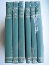
Mapping the Transmississippi West [1995, 6 separate vols, complete; with large FOLD-OUT maps; new, in publisher's shrinkwrap & PUBLISHER'S CARDBOARD SHIPPING BOX
by Wheat, Carl I.
- New
- Hardcover
- first
- Condition
- New
- Jacket Condition
- in publisher's shrinkwrap
- Edition
- First Martino/About Books printing
- Binding
- Hardcover
- Quantity Available
- 1
- Seller
-
Henderson, Nevada, United States
- Item Price
-
£524.02
Show Details
Description:
Storrs-Mansfield, CT / Parsippany, New Jersey: Martino Fine Books / About Books, 1995. 6 separate volumes, complete [5 volumes bound in 6 books WITH LARGE FOLD-OUT MAPS -- just like the first edition]. SEE PHOTOS. Each of the 6 books in this 1995 large format edition measures 9.25" wide by 12.25" tall. [This is NOT the later, smaller format 3-volume reprint in which the maps are reduced in size]. Unlike later reduced-size editions, the maps in this 1995 six-volume edition measure as large as 21" by 33" when unfolded. SEE PHOTOS. As original co-publisher, we are pleased to offer the few remaining sets of the 1995 large-format 6-volume edition (recently rediscovered in our warehouse). They are BRAND NEW in perfect condition. STILL SEALED in the publisher's clear plastic SHRINKWRAP and the PUBLISHER'S CARDBOARD SHIPPING BOX. NO rubbing. NO fading. Bright, clean, square and tight. NO owner's name or bookplate. NOT a remainder. Fresh and crisp -- obviously…
Read More Item Price
£524.02

More Photos
Hudson River and the Hudson River Railroad: with a complete map and wood cut views of the principal objects of interest upon the line
by HUDSON RIVER RAILROAD
- Used
- Condition
- Used - Wrappers chipped at edges, professionally rebacked, some unobtrusive offsetting on map
- Binding
- Unknown
- Quantity Available
- 1
- Seller
-
Ardsley, New York, United States
- Item Price
-
£809.30
Show Details
Description:
New York: Wm. C. Locke & Co, 1851. Wrappers chipped at edges, professionally rebacked, some unobtrusive offsetting on map. 8vo. 50 pages. Large folding map on three joined sheets (21 x 1788 cm; 8.25 x 61.75 inches). 11 woodblock illustrations in text (and with 2 more not recorded in the index but always present). Original printed wrappers with woodblock vignette. SCARCE Hudson River Railroad travel guide published the first year in which the full line was completed. It covers points of interest along the route, with woodblocks illustrating the text. Topics include: the history of the Hudson River, the history of the construction of the Hudson River Railroad, and the cities, towns and villages along the Hudson, from New York City all the way to Troy. Concerning the West Point Foundry at Cold Spring, the guide states: "the iron foundry [was] established here by Gouverneur Kemble. The works are situated about a mile west of the village, upon a small stream which tumbles rapidly down the mountains,…
Read More Item Price
£809.30

More Photos
Gall and Inglis’ School Atlas of Modern Geography
by Gall and Inglis
- Used
- near fine
- Hardcover
- Condition
- Used - Near Fine
- Binding
- Hardcover
- Quantity Available
- 1
- Seller
-
COLUMBIA, Missouri, United States
- Item Price
-
£606.98
Show Details
Description:
1861 RARE Gall Inglis ATLAS Geography China America Australia 31 COLOR MAPSGall and Inglis' "School Atlas of Modern Geography" is a civil war compilation of 31 royal quarto maps. This 1861 edition includes maps of Europe, England and Wales, Ireland, Scotland, North America, South America, Switzerland, Turkey, Hindostan, and much more!
Item number: #13467
Price: $750
Gall and Inglis
Gall and Inglis' School Atlas of Modern Geography
Edinburgh: Gall & Inglis, 1861.
Details:
·
Collation: Complete with all pages
o 31 color maps
· Language: English
· Binding: Hardcover; tight & secure
o
Cloth
· Size: ~12.5in X 9.75in (31.5cm x 25cm)
Our Guarantee:
Very Fast. Very Safe. Free Shipping Worldwide.
Customer satisfaction is our priority! Notify us with 7 days of receiving, and we will offer a full refund without reservation!
13467Photos available upon request.
Item Price
£606.98

More Photos
A star atlas for the library, the school, and the observatory showing 6,000 stars and 1,500 objects of interest
by PROCTOR, Richard A
- Used
- near fine
- Hardcover
- Condition
- Used - Near Fine
- Binding
- Hardcover
- Quantity Available
- 1
- Seller
-
COLUMBIA, Missouri, United States
- Item Price
-
£484.77
Show Details
Description:
1874 Astronomy Star ATLAS Zodiac Constellation MAPS Richard Proctor AstrologyRichard Proctor was a 19th-century English astronomer known for his studies on the planets in the solar system as well as the moon and the sun. In his many astronomical books, Proctor discusses his research on the planets, stars and constellations, and the sun, as well as his observations on meteors and comets. His most fascinating work was 'A Star Atlas' – an impressive collection of star and constellation charts and night sky maps.
Item number: #19450
Price: $599
PROCTOR, Richard A
A star atlas for the library, the school, and the observatory showing 6,000 stars and 1,500 objects of interest
London : Longmans, Green, 1874.
Details:
· Collation: Complete with all pages
o
14, [2]
o
14 double-page charts
· Language: English
· Binding: Hardcover; tight and secure
o
Cloth
· Size: ~14.75in X 9.75in (37.5cm x 25cm)
· Quite scarce
Our Guarantee:
Very Fast. Very Safe. Free Shipping… Read More
Item Price
£484.77
Stock Photo: Cover May Be Different
Tiger Claws : A Novel of India
by Speed, John
- Used
- Condition
- Used - Good
- ISBN 10 / ISBN 13
- 9780312325510 / 0312325517
- Quantity Available
- 1
- Seller
-
Mishawaka, Indiana, United States
- Item Price
-
£4.61
Show Details
Description:
St. Martin's Press. Used - Good. Former library book; may include library markings. Used book that is in clean, average condition without any missing pages.
Item Price
£4.61

Stock Photo: Cover May Be Different
The Temple Dancer : A Novel of India
by Speed, John
- Used
- Condition
- Used - Very Good
- ISBN 10 / ISBN 13
- 9780312325497 / 0312325495
- Quantity Available
- 1
- Seller
-
Mishawaka, Indiana, United States
- Item Price
-
£4.64
Show Details
Description:
St. Martin's Press. Used - Very Good. Used book that is in excellent condition. May show signs of wear or have minor defects.
Item Price
£4.64
Stock Photo: Cover May Be Different
The Temple Dancer : A Novel of India
by Speed, John
- Used
- Condition
- Used - Good
- ISBN 10 / ISBN 13
- 9780312325480 / 0312325487
- Quantity Available
- 1
- Seller
-
Reno, Nevada, United States
- Item Price
-
£4.75
Show Details
Description:
St. Martin's Press. Used - Good. Former library book; may include library markings. Used book that is in clean, average condition without any missing pages.
Item Price
£4.75

The Counties of Britain : A Tudor Atlas
by John Speed
- Used
- good
- Paperback
- Condition
- Used - Good
- Binding
- Paperback
- ISBN 10 / ISBN 13
- 9781857936124 / 1857936124
- Quantity Available
- 1
- Seller
-
Seattle, Washington, United States
- Item Price
-
£5.35
Show Details
Description:
Pavilion Books, 1995. Paperback. Good. Disclaimer:A copy that has been read, but remains in clean condition. All pages are intact, and the cover is intact. The spine may show signs of wear. Pages can include limited notes and highlighting, and the copy can include previous owner inscriptions. At ThriftBooks, our motto is: Read More, Spend Less.Dust jacket quality is not guaranteed.
Item Price
£5.35

The Counties of Britain : A Tudor Atlas
by John Speed
- Used
- Acceptable
- Paperback
- Condition
- Used - Acceptable
- Binding
- Paperback
- ISBN 10 / ISBN 13
- 9781857936124 / 1857936124
- Quantity Available
- 2
- Seller
-
Seattle, Washington, United States
- Item Price
-
£5.35
Show Details
Description:
Pavilion Books, 1995. Paperback. Acceptable. Disclaimer:A readable copy. All pages are intact, and the cover is intact. Pages can include considerable notes-in pen or highlighter-but the notes cannot obscure the text. At ThriftBooks, our motto is: Read More, Spend Less.Dust jacket quality is not guaranteed.
Item Price
£5.35
Stock Photo: Cover May Be Different
The Counties of Britain: A Tudor Atlas
by Speed, John
- Used
- good
- Paperback
- Condition
- Used - Good
- Binding
- Paperback
- ISBN 10 / ISBN 13
- 9781857936124 / 1857936124
- Quantity Available
- 1
- Seller
-
Seattle, Washington, United States
- Item Price
-
£5.35
Show Details
Description:
Trafalgar Square Publishing, 1995. Paperback. Good. Missing dust jacket; Pages can have notes/highlighting. Spine may show signs of wear. ~ ThriftBooks: Read More, Spend Less.Dust jacket quality is not guaranteed.
Item Price
£5.35

The Counties of Britain: A Tudor Atlas.
by Speed, John
- Used
- very good
- Hardcover
- Condition
- Used - Very Good
- Binding
- Hardcover
- ISBN 10 / ISBN 13
- 9781851451319 / 1851451315
- Quantity Available
- 2
- Seller
-
Seattle, Washington, United States
- Item Price
-
£5.54
Show Details
Description:
Pavilion Books, 1992. Hardcover. Very Good. May have limited writing in cover pages. Pages are unmarked. ~ ThriftBooks: Read More, Spend Less.Dust jacket quality is not guaranteed.
Item Price
£5.54

The Temple Dancer : A Novel of India
by John Speed
- Used
- Acceptable
- Paperback
- Condition
- Used - Acceptable
- Binding
- Paperback
- ISBN 10 / ISBN 13
- 9780312325497 / 0312325495
- Quantity Available
- 1
- Seller
-
Seattle, Washington, United States
- Item Price
-
£5.55
Show Details
Description:
St. Martin's Press, 2007. Mass Market Paperback. Acceptable. Readable copy. Pages may have considerable notes/highlighting. ~ ThriftBooks: Read More, Spend Less.Dust jacket quality is not guaranteed.
Item Price
£5.55
Stock Photo: Cover May Be Different
Tiger Claws : A Novel of India
by Speed, John
- Used
- Condition
- Used - Like New
- ISBN 10 / ISBN 13
- 9780312325510 / 0312325517
- Quantity Available
- 1
- Seller
-
Reno, Nevada, United States
- Item Price
-
£5.71
Show Details
Description:
St. Martin's Press. Used - Like New. Used book that is in almost brand-new condition.
Item Price
£5.71
Stock Photo: Cover May Be Different
The Temple Dancer : A Novel of India
by Speed, John
- Used
- Condition
- Used - Good
- ISBN 10 / ISBN 13
- 9780312325497 / 0312325495
- Quantity Available
- 1
- Seller
-
Mishawaka, Indiana, United States
- Item Price
-
£5.74
Show Details
Description:
St. Martin's Press. Used - Good. Used book that is in clean, average condition without any missing pages.
Item Price
£5.74

More Photos
The Sky and the Forest
by Forester, C.S
- Used
- very good
- Hardcover
- first
- Condition
- Used - Very Good
- Jacket Condition
- Very Good
- Edition
- First Edition
- Binding
- Hardcover
- Quantity Available
- 1
- Seller
-
Salem, Oregon, United States
- Item Price
-
£28.24£16.94Save £13.96!
Show Details
Description:
C.S. Forester: The Sky and the Forest. Little, Brown and Company, Boston. Stated First Edition First Printing Thus August, 1948. Cover price $2.75. Used. VG BOOK/VG UNCLIPPED DUST JACKET. A story of a central Africa. By C.S. Forester, author of the Admiral Hornblower series.
Item Price
£28.24£16.94
Save £13.96
!
![Alaska and Klondike Region; [With inset of Klondike Region on the Upper Yukon detail] [From an...](https://d3525k1ryd2155.cloudfront.net/h/062/537/1339537062.0.m.jpg)
Alaska and Klondike Region; [With inset of Klondike Region on the Upper Yukon detail] [From an atlas, "Gazetteer of Alaska and Yukon Region " pp. 105 and 106]
by Miller, J. Martin
- Used
- very good
- Condition
- Used - Very Good
- Edition
- Unknown
- Quantity Available
- 1
- Seller
-
Sebastopol, California, United States
- Item Price
-
£31.56
Show Details
Description:
Chicago: J. Martin Miller, 1899. Unknown. Map. Very Good. [Map copyright 1899, printing date of Atlas later] [19.875x15.125in]; Colored map of Alaska with steamer routes from Portland and Seattle, insets of the Klondike Region on the Upper Yukon and Western portion of Aleutian Islands; On verso index of places and names with two large black and white images; Age toning to all edges, water stain marks on bottom, slight printing offset of colors, small chips and closed tears to lower edge;.
Item Price
£31.56

Zemepis Sveta - Monsunova Asie
by De La Blache, P. Vidal; Gallois, L
- Used
- Hardcover
- Condition
- Used - Very Good Condition
- Jacket Condition
- No Dust Jacket
- Binding
- Hardcover
- Quantity Available
- 1
- Seller
-
Oak Point, Texas, United States
- Item Price
-
£48.56
Show Details
Description:
Aventinum, Prague, Czechoslovakia, 1931. Hardcover. Very Good Condition/No Dust Jacket. Text entirely in Czech. Geography book on Asia with numerous photographs and maps. 1930 edition also available. Size: 4mo - over 9 3/4" - 12" tall. 400 pp. Pages are yellowed, but are tight and clean. Moderate shelfwear along the spine. Corners are lightly bumped. Quantity Available: 1. Shipped Weight: 3-5 pounds. Category: Travel & Places; Non-English Language::Czech; Pictures of this item not already displayed here available upon request. Inventory No: 001228. . Additional shipping charges may apply.
Item Price
£48.56

Zemepis Sveta - Monsunova Asie
by De La Blache, P. Vidal; Gallois, L
- Used
- Hardcover
- Condition
- Used - Very Good Condition
- Jacket Condition
- No Dust Jacket
- Binding
- Hardcover
- Quantity Available
- 1
- Seller
-
Oak Point, Texas, United States
- Item Price
-
£48.56
Show Details
Description:
Aventinum, Prague, Czechoslovakia, 1930. Hardcover. Very Good Condition/No Dust Jacket. Text entirely in Czech. Geography book on Asia with numerous photographs and maps. 1931 edition also available. Size: 4mo - over 9 3/4" - 12" tall. 400 pp. Pages are yellowed, but are tight and clean. Moderate shelfwear along the spine. Corners are lightly bumped. Quantity Available: 1. Shipped Weight: 3-5 pounds. Category: Travel & Places; Non-English Language::Czech; Pictures of this item not already displayed here available upon request. Inventory No: 001227. . Additional shipping charges may apply.
Item Price
£48.56

North America from the Best Authorities, Russell, ca.1800
by Russell
- Used
- Condition
- Used
- Quantity Available
- 1
- Seller
-
Plymouth, Devon, United Kingdom
- Item Price
-
£20.00
Show Details
Description:
Russell, J. : A General Map of North America from the Best Authorities. Nd but ca.1800. From "A New Geographical, Historical and Commercial Grammar and Present State of Several Kingdoms of the World." Copper engraving. Size approx 200 x 230mm. Two neat folds. Some age colouring to edges, otherwise very clean and bright.
Item Price
£20.00

Asia from the Best Authorities, Russell, ca.1800
by Russell
- Used
- Condition
- Used
- Quantity Available
- 1
- Seller
-
Plymouth, Devon, United Kingdom
- Item Price
-
£20.00
Show Details
Description:
Russell, J. : Asia from the Best Authorities. Nd but ca.1800. From "A New Geographical, Historical and Commercial Grammar and Present State of Several Kingdoms of the World". Copper engraving. Size approx 200 x 230mm. Two neat folds. Some age colouring to edges, otherwise clean and bright. Includes Arabia, India, Borneo, Japan, China and eastern Russia.
Item Price
£20.00
![MAP OF UTAH [Territory]](https://d3525k1ryd2155.cloudfront.net/h/836/461/1485461836.0.m.jpg)
More Photos
MAP OF UTAH [Territory]
- Used
- Condition
- Used - Very Good-
- Edition
- Original
- Quantity Available
- 1
- Seller
-
Williamsburg, Virginia, United States
- Item Price
-
£52.60
Show Details
Description:
New York, Richmond, Chicago, & Toledo: H. H. Hardesty, 1885. Original color lithographed map printed by Rand, McNally & Company, Engravers and published in HARDESTY'S HISTORICAL AND GEOGRAPHICAL ENCYCLOPEDIA: SPECIAL VIRGINIA EDITION. 19 3/8 inches by 13 1/4 inches on a 21" X 14 1/2" sheet. The map depicts the Territory of Utah in its final form--large areas had been removed and ceded to Nevada, Colorado, Wyoming, and Nebraska since Utah became a U. S. Territory in 1850. The issue of polygamy prevented statehood until it was finally granted in 1896. This map features railroads and topography and uses color to set off counties from each other. Unlike most atlas maps of the period, this map identifies most small towns. The map is guaranteed to be moe than 135 years old. The map is in about very good condition: generally clean and bright, with slight toning of paper and one faint water stain near the center-left edge of the map.. Original. Single Sheet. Very Good-. Elephant…
Read More Item Price
£52.60

Philips Special Map of the Nile, The Advance on Khartum and the Environs of Omdurman. Cc1900
by George Philips and Son,
- Used
- Condition
- Used
- Quantity Available
- 1
- Seller
-
Plymouth, Devon, United Kingdom
- Item Price
-
£26.00
Show Details
Description:
Philips Special map of the Nile illustrating the Advance on Khartum [Khartoum] with an enlargement of the environs of Omdurman [Omdur]. George Philips and Son, London and Liverpool Ca 1900. 580mm x 900mm folded map. Front title wrapper has come loose, not affecting map area. Three maps are displayed within the sheet. Map1. Map of the Nile Valley 520mm x 300mm showing the approaches of Khartum. Scale 1inch to 100 Geographical miles. Coloured indicating Possessions and Protectorates of European Powers. Map 2. Special map of the Nile from Dongola to Khartum. Scale 16 miles to the inch. Coloured. In set in this map is Map3. Environs of Omdurman, Scale 5 statute miles to the inch. Some small breaks at some folds, not affecting imagery or use of map. Title label is damaged, the map is clean and bright, probably unused. A very interesting record.
Item Price
£26.00

Last Tales
by Dinesen, Isak
- Used
- very good
- Hardcover
- first
- Condition
- Used - Very Good
- Jacket Condition
- Good+
- Edition
- First Edition
- Binding
- Hardcover
- Quantity Available
- 1
- Seller
-
Salem, Oregon, United States
- Item Price
-
£97.12£58.27Save £48.00!
Show Details
Description:
Dinesen, Isak: Last Tales, A Collection of Twelve New Tales of Compelling Beauty 1957, Random House. First Edition. Stated First Printing Thus. Used. Very Good/Good+ original red dust jacket, price-clipped. Jacket states 11/57 on front flap. 5 3/4 X
Item Price
£97.12£58.27
Save £48.00
!

The Adventure of Wrangel Island
by Vilhjalmur Stefansson
- Used
- good
- Hardcover
- first
- Condition
- Used - Good
- Jacket Condition
- No DJ Included
- Edition
- First Edition
- Binding
- Hardcover
- Quantity Available
- 1
- Seller
-
Salem, Oregon, United States
- Item Price
-
£101.07£60.64Save £49.96!
Show Details
Description:
The Adventure of Wrangel Island, Alaska (1925 Macmillan 1st Edition) HISTORY OF ALASKA. EXLIB. Good Condition/ No DJ included. Fold-out map affixed to binding at the back of the book has never been opened. The story of the (unsuccessful) attempted colonization of Wrangel Island Alaska. 413 pages plus appendix, Index. Titling is still bright. A clean, solid copy. Scarce.
Item Price
£101.07£60.64
Save £49.96
!
