Description:
n.p.: n.p., 1685. Loose leaf. Fine. Original hand colored copper engraving depicting the Equator and lines of latitude superimposed over Europe, Asia, Africa and Antarctica. Image size: 4 1/4 x 5 1/2 inches. Framed and conserved. Frame size: 11 7/8 x 13 3/4 inches. A fine hand colored 17th Century map of Europe, Asia, Africa and Antarctica.
A Description of the Strata Which Occur in Ascending from the Plains of Kincardineshire to the Summit of Mount Battoc, One of the Most Elevated Points in the Eastern District of the Grampian Mountains by Ninian, Imrie. (c1750-1820) - 1806
by Ninian, Imrie. (c1750-1820)

A Description of the Strata Which Occur in Ascending from the Plains of Kincardineshire to the Summit of Mount Battoc, One of the Most Elevated Points in the Eastern District of the Grampian Mountains
by Ninian, Imrie. (c1750-1820)
- Used
- very good
- first
Edinburgh: Royal Society of Edinburgh, 1806. 1st Edition. Soft cover in modern boards. Very Good/No Dust Jacket As Issued. Sewn Binding. 19 pages. 12 inches tall. 9 ¼ inches wide
Description: Paper read March 5, 1804. Transactions of the Royal Society of Edinburgh Vol. VI, Part I.
Only one original is located in an institution. [OCLC/WorldCat]. The Grampian Mountains are one of the three major mountain ranges in Scotland, occupying a considerable portion of the Scottish Highlands in northern Scotland. The other major mountain ranges in Scotland are the Northwest Highlands and the Southern Uplands.
REF: OCLC: 21066936 - 1 copy. UCLA; Bodl: 014477837 [a reprint made in 1812 1 copy]; Griffiths: 398.
Description: Paper read March 5, 1804. Transactions of the Royal Society of Edinburgh Vol. VI, Part I.
The antique journal article has been sewn into modern protective boards with cloth backing. A paper label appears on the front board. Modern boards show lightly bumped outside corners. Original Pages show sporadic foxing with toning. Contains in-text illustrations and large fold-out plate/map that measures approximately 38" x 10.5".
Only one original is located in an institution. [OCLC/WorldCat]. The Grampian Mountains are one of the three major mountain ranges in Scotland, occupying a considerable portion of the Scottish Highlands in northern Scotland. The other major mountain ranges in Scotland are the Northwest Highlands and the Southern Uplands.
REF: OCLC: 21066936 - 1 copy. UCLA; Bodl: 014477837 [a reprint made in 1812 1 copy]; Griffiths: 398.
-
Bookseller
Independent bookstores
 (US)
(US)
- Format/Binding Soft cover in modern boards
- Book Condition Used - Very Good
- Jacket Condition No Dust Jacket As Issued
- Quantity Available 1
- Edition 1st Edition
- Publisher Royal Society of Edinburgh
- Place of Publication Edinburgh
- Date Published 1806
- Keywords Geography, Map; Geology

More Photos
Paralleles de Latitude, from Description de L'Univers
by [Mallet, Allain Mannesson]
- Used
- Fine
- Condition
- Used - Fine
- Binding
- Unknown
- Quantity Available
- 1
- Seller
-
Fayetteville, Arkansas, United States
- Item Price
-
£224.88
Show Details
Item Price
£224.88

More Photos
Cercles de Longitude, from Description de L'Univers
by [Mallet, Allain Mannesson]
- Used
- Fine
- Condition
- Used - Fine
- Binding
- Unknown
- Quantity Available
- 1
- Seller
-
Fayetteville, Arkansas, United States
- Item Price
-
£224.88
Show Details
Description:
n.p.: n.p., 1685. Loose leaf. Fine. Original hand colored copper engraving depicting the Equator and lines of longitude (including the Prime Meridian) superimposed over Europe, Asia, Africa and Antarctica. Image size: 4 1/4 x 5 1/2 inches. Professionally conserved, matted and framed. Frame size: 11 7/8 x 13 3/4 inches. A fine hand colored 17th Century map of Europe, Asia, Africa and Antarctica.
Item Price
£224.88
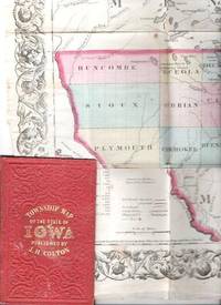
COLTON'S TOWNSHIP MAP OF THE STATE OF IOWA: Compiled from the United Statees Surveys & other Authentic Sources.; Drawn by George W. Colton. Engraved by J.M. Atwood
by Iowa
- Used
- good
- Condition
- Used - Good
- Edition
- 1855 edition
- Binding
- Unknown
- Quantity Available
- 1
- Seller
-
Roosevelt, New Jersey, United States
- Item Price
-
£242.85
Show Details
Description:
New York: J.H. Colton & Co, 1855. 1855 edition. Original Cloth. Good. Full-color engraved map, colored by hand, scrollwork border on all sides, opens to 25" x 29"; repairable separations at the intersections of several folds. Folds into red cloth case with embossed all-over design on both covers, gilt lettering on front. 5.5" x 3.75" [OCLC locates three holdings of this edition: Grinnell Col, U Iowa, Stanford U. Decker 23:225--1870 edition.].
Item Price
£242.85

More Photos
Arab navigation in the Indian Ocean before the coming of the Portuguese
by Ahmad ibn Majid al-Sadi , G.R. Tibbetts
- Used
- Hardcover
- first
- Condition
- Very Good: Cover some light shelf wear, inside as new
- Edition
- First Edition
- Binding
- Hardcover
- ISBN 10 / ISBN 13
- 9780718909000 / 0718909003
- Quantity Available
- 1
- Seller
-
Berg en dal, Netherlands
- Item Price
-
£208.15
Show Details
Description:
Ahmad ibn Majid al-Sadi, G.R. Tibbetts - Arab Navigation in the Indian Ocean before the coming of the Portuguese - London, The Royal Asiatic Society of Great Britain and Ireland; Luzac and Company Ltd, 1971 - First Edition - Hardcover - 614pp + 4 maps (out of 7)- 22x14 cmCondition Very Good: Cover some light shelf wear, inside as new. Four out of seven maps present: Chart of the Arabian Sea, India and the Bay of Bengal, Red Sea and Gulf of Eden, East African CoastIf you have any questions or want to see more pictures, feel free to ask.Your book will be securely packed and shipped with tracking number, signed & insured.
Item Price
£208.15

More Photos
1875 ILLINOIS CENTRAL MAP.: Map of the Illinois Central Railroad and its Connections.
- Used
- Condition
- Used
- Quantity Available
- 1
- Seller
-
Houston, Texas, United States
- Item Price
-
£238.80
Show Details
Description:
[Railroad] Map of the Illinois Central Railroad and its Connections. Chicago: Rand McNally and Company Map Engravers. 1875. Map printed on green paper. 33 x 25 on sheet 40 x 38 cm folded to 9 x 19 cm. Added text printed in green in margins around map. One three inch fold split, else very good.OCLC shows one holding (Newberry Lib.) Relief shown by hachures. Timetables on verso "corrected to June 20th, 1875." Text describing routes and connections on 5 panels on verso: Illinois Central Railroad principal connections -- Illinois Central Railroad Dubuque and Sioux City Line! -- Illinois Central Railroad, the direct route from Chicago to Springfield, Farmer City, Clinton and Mt. Pulaski -- Illinois Central Railroad St. Louis through line -- Illinois Central Railroad New Orleans through line.
Item Price
£238.80

More Photos
Plan of the Battle of Waterloo
by Edward Cotton
- Used
- good
- Hardcover
- Condition
- Used - Good
- Binding
- Hardcover
- Quantity Available
- 1
- Seller
-
Boonsboro, Maryland, United States
- Item Price
-
£257.83
Show Details
Description:
1854. Hardcover. Good. Lithograph map with original hand-colored highlights. Approximately 12 1/4 X 12 1/2" on 18 X 18" sheet with extensive printed text at all margins. Title and credit in the map at upper right, good condition with some aging at folds. <br> Original slim 12mo dark green leather-covered board folder with gilt lettering at upper cover. Some scuffing and wear at edges. Additional smaller lithograph map with hand-colored highlights mounted at inside of upper cover. Lengthy 1858 pencil notation of purchase ("on the Field of Waterloo") from Cotton's niece on verso of map.
Item Price
£257.83

More Photos
SMITH'S NEW MAP OF PHILADELPHIA AND VICINITY
by Smith, J. L.
- Used
- Hardcover
- Condition
- Used - Very Good+
- Binding
- Hardcover
- Quantity Available
- 1
- Seller
-
Fairfield, New Jersey, United States
- Item Price
-
£226.66
Show Details
Description:
Philadelphia: J. L. Smith. Very Good+. 1898. Hardcover. One large map Issued in two separate sheets; each 23" x 27 1/2". The folding maps are backed on linen. The maps are mounted in a green cloth hardcover folder with bright glit title on front. Pennsylvania; Thin 12mo 7" - 7½" tall .
Item Price
£226.66

More Photos
Digging the Old West: How Dams and Ditches Sculpted an American Landscape
by Franklin, Karmen Lee
- Used
- Paperback
- Condition
- Used- Fine
- Binding
- Paperback
- ISBN 10 / ISBN 13
- 9780615531489 / 0615531482
- Quantity Available
- 1
- Seller
-
Longmont, Colorado, United States
- Item Price
-
£222.61
Show Details
Description:
Franklin Design Bureau, 2011. Paperback. Used- Fine condition. Book is clean and tight. Book shows light shelf wear. Light bumping on the top and bottom of the spine. No markings on the inside of the book. Photos are of the book we have here at Barbed Wire Books."It is one of the few works that attempts fully to explain Colorado's water history. It is unusually well-written, with vivid descriptions of people, processes, events, and landscape features." Mark Fiege
Item Price
£222.61

More Photos
Historical map of Nantucket, 1869.
by Ferdinand C. Ewer
- Used
- Condition
- Used
- Quantity Available
- 1
- Seller
-
Houston, Texas, United States
- Item Price
-
£202.38
Show Details
Description:
[Nantucket] [Cape Cod] Ferdinand C. Ewer. Historical map of Nantucket, 1869. [Boston]: [publisher not identified] [Circa 1886-1900] Map 22 x 35 cm. Has been folded. Splits at folds, else very good. OCLC shows ten holdings (Harvard; Salem St.; Univ. Chicago; Boston Public. Lib.; RB Hayes Ctr; Brown Univ.; Dartmouth; Bryn Mawr Col.; Wisc. Hist. Soc. [2]) Surveyed and drawn by the Rev. F.C. Ewer, D.D., 1869. Reduced copy issued by the Old Colony Railroad as an advertisement of its Old Colony Line of steamboats to the Island. Includes historical text. Will frame and display well.
Item Price
£202.38

More Photos
Map of America
by Wyld, James Jr.
- Used
- Condition
- Used
- Quantity Available
- 1
- Seller
-
Port Hope, Ontario, Canada
- Item Price
-
£238.80
Show Details
Description:
Copperplate engraved map with hand colouring. Chips to margins with minor losses, small closed tear upper left corner, a few light creases, small perforation to either side of centrefold (more visible on verso), verso c/f reinforced with tape but on the whole very good20-1/2" x 22-3/4"- 57.1 x 57.7 cm.
A detailed map of North America, the Caribbean, South America and the Pacific Islands. Alaska is still part of Russian possessions, and Texas stands as a Republic. James Wyld Jr. took over the family business in the mid 19th Century and continued to produce highly detailed maps of all regions of the world.
Item Price
£238.80

A Description and Section of the Strata of the Grampian Mountains, from the Plain of Kincardineshire to the Summit of Mount Battock.
by Lieutenant-Colonel [Ninian] Imrie
- Used
- Paperback
- Condition
- Used, acceptable
- Binding
- Paperback
- Quantity Available
- 1
- Seller
-
Kinnelon, New Jersey, United States
- Item Price
-
£971.40
Show Details
Description:
Royal Society of Edinburgh,, 1811.. Paperback. Used, acceptable. Original 1811 edition/printing. Large softcover (10.6"x8.7"), dark brown wraps, 39pp, folding hand-colored cross section attached at back. Back wrap missing, front wrap separated from book and quite torn with large chips missing; binding has fallen apart so signatures are loose; pages somewhat brittle, 3" tear in first two page due to their being turned without sufficient care, outer page edges missing many very small chips due to wear; title page very lightly soiled with what appears to have been water spatter. Foldout is on fairly heavy stock that has aged well and is like new except the reverse (blank side) is somewhat dampstained. Title is hand-written on the front cover; small library stamp on front cover. Interior has no marks or writing. Overall acceptable-plus condition. OVERSIZE. ** We are a small family business selling fine new and pre-owned books online since 1999. We provide professional service and…
Read More Item Price
£971.40

More Photos
The Sky and the Forest
by Forester, C.S
- Used
- very good
- Hardcover
- first
- Condition
- Used - Very Good
- Jacket Condition
- Very Good
- Edition
- First Edition
- Binding
- Hardcover
- Quantity Available
- 1
- Seller
-
Salem, Oregon, United States
- Item Price
-
£28.24£16.94Save £13.96!
Show Details
Description:
C.S. Forester: The Sky and the Forest. Little, Brown and Company, Boston. Stated First Edition First Printing Thus August, 1948. Cover price $2.75. Used. VG BOOK/VG UNCLIPPED DUST JACKET. A story of a central Africa. By C.S. Forester, author of the Admiral Hornblower series.
Item Price
£28.24£16.94
Save £13.96
!
![Alaska and Klondike Region; [With inset of Klondike Region on the Upper Yukon detail] [From an...](https://d3525k1ryd2155.cloudfront.net/h/062/537/1339537062.0.m.jpg)
Alaska and Klondike Region; [With inset of Klondike Region on the Upper Yukon detail] [From an atlas, "Gazetteer of Alaska and Yukon Region " pp. 105 and 106]
by Miller, J. Martin
- Used
- very good
- Condition
- Used - Very Good
- Edition
- Unknown
- Quantity Available
- 1
- Seller
-
Sebastopol, California, United States
- Item Price
-
£31.57
Show Details
Description:
Chicago: J. Martin Miller, 1899. Unknown. Map. Very Good. [Map copyright 1899, printing date of Atlas later] [19.875x15.125in]; Colored map of Alaska with steamer routes from Portland and Seattle, insets of the Klondike Region on the Upper Yukon and Western portion of Aleutian Islands; On verso index of places and names with two large black and white images; Age toning to all edges, water stain marks on bottom, slight printing offset of colors, small chips and closed tears to lower edge;.
Item Price
£31.57

Zemepis Sveta - Monsunova Asie
by De La Blache, P. Vidal; Gallois, L
- Used
- Hardcover
- Condition
- Used - Very Good Condition
- Jacket Condition
- No Dust Jacket
- Binding
- Hardcover
- Quantity Available
- 1
- Seller
-
Oak Point, Texas, United States
- Item Price
-
£48.57
Show Details
Description:
Aventinum, Prague, Czechoslovakia, 1930. Hardcover. Very Good Condition/No Dust Jacket. Text entirely in Czech. Geography book on Asia with numerous photographs and maps. 1931 edition also available. Size: 4mo - over 9 3/4" - 12" tall. 400 pp. Pages are yellowed, but are tight and clean. Moderate shelfwear along the spine. Corners are lightly bumped. Quantity Available: 1. Shipped Weight: 3-5 pounds. Category: Travel & Places; Non-English Language::Czech; Pictures of this item not already displayed here available upon request. Inventory No: 001227. . Additional shipping charges may apply.
Item Price
£48.57

Zemepis Sveta - Monsunova Asie
by De La Blache, P. Vidal; Gallois, L
- Used
- Hardcover
- Condition
- Used - Very Good Condition
- Jacket Condition
- No Dust Jacket
- Binding
- Hardcover
- Quantity Available
- 1
- Seller
-
Oak Point, Texas, United States
- Item Price
-
£48.57
Show Details
Description:
Aventinum, Prague, Czechoslovakia, 1931. Hardcover. Very Good Condition/No Dust Jacket. Text entirely in Czech. Geography book on Asia with numerous photographs and maps. 1930 edition also available. Size: 4mo - over 9 3/4" - 12" tall. 400 pp. Pages are yellowed, but are tight and clean. Moderate shelfwear along the spine. Corners are lightly bumped. Quantity Available: 1. Shipped Weight: 3-5 pounds. Category: Travel & Places; Non-English Language::Czech; Pictures of this item not already displayed here available upon request. Inventory No: 001228. . Additional shipping charges may apply.
Item Price
£48.57

Asia from the Best Authorities, Russell, ca.1800
by Russell
- Used
- Condition
- Used
- Quantity Available
- 1
- Seller
-
Plymouth, Devon, United Kingdom
- Item Price
-
£20.00
Show Details
Description:
Russell, J. : Asia from the Best Authorities. Nd but ca.1800. From "A New Geographical, Historical and Commercial Grammar and Present State of Several Kingdoms of the World". Copper engraving. Size approx 200 x 230mm. Two neat folds. Some age colouring to edges, otherwise clean and bright. Includes Arabia, India, Borneo, Japan, China and eastern Russia.
Item Price
£20.00

North America from the Best Authorities, Russell, ca.1800
by Russell
- Used
- Condition
- Used
- Quantity Available
- 1
- Seller
-
Plymouth, Devon, United Kingdom
- Item Price
-
£20.00
Show Details
Description:
Russell, J. : A General Map of North America from the Best Authorities. Nd but ca.1800. From "A New Geographical, Historical and Commercial Grammar and Present State of Several Kingdoms of the World." Copper engraving. Size approx 200 x 230mm. Two neat folds. Some age colouring to edges, otherwise very clean and bright.
Item Price
£20.00
![MAP OF UTAH [Territory]](https://d3525k1ryd2155.cloudfront.net/h/836/461/1485461836.0.m.jpg)
More Photos
MAP OF UTAH [Territory]
- Used
- Condition
- Used - Very Good-
- Edition
- Original
- Quantity Available
- 1
- Seller
-
Williamsburg, Virginia, United States
- Item Price
-
£52.62
Show Details
Description:
New York, Richmond, Chicago, & Toledo: H. H. Hardesty, 1885. Original color lithographed map printed by Rand, McNally & Company, Engravers and published in HARDESTY'S HISTORICAL AND GEOGRAPHICAL ENCYCLOPEDIA: SPECIAL VIRGINIA EDITION. 19 3/8 inches by 13 1/4 inches on a 21" X 14 1/2" sheet. The map depicts the Territory of Utah in its final form--large areas had been removed and ceded to Nevada, Colorado, Wyoming, and Nebraska since Utah became a U. S. Territory in 1850. The issue of polygamy prevented statehood until it was finally granted in 1896. This map features railroads and topography and uses color to set off counties from each other. Unlike most atlas maps of the period, this map identifies most small towns. The map is guaranteed to be moe than 135 years old. The map is in about very good condition: generally clean and bright, with slight toning of paper and one faint water stain near the center-left edge of the map.. Original. Single Sheet. Very Good-. Elephant…
Read More Item Price
£52.62

Philips Special Map of the Nile, The Advance on Khartum and the Environs of Omdurman. Cc1900
by George Philips and Son,
- Used
- Condition
- Used
- Quantity Available
- 1
- Seller
-
Plymouth, Devon, United Kingdom
- Item Price
-
£26.00
Show Details
Description:
Philips Special map of the Nile illustrating the Advance on Khartum [Khartoum] with an enlargement of the environs of Omdurman [Omdur]. George Philips and Son, London and Liverpool Ca 1900. 580mm x 900mm folded map. Front title wrapper has come loose, not affecting map area. Three maps are displayed within the sheet. Map1. Map of the Nile Valley 520mm x 300mm showing the approaches of Khartum. Scale 1inch to 100 Geographical miles. Coloured indicating Possessions and Protectorates of European Powers. Map 2. Special map of the Nile from Dongola to Khartum. Scale 16 miles to the inch. Coloured. In set in this map is Map3. Environs of Omdurman, Scale 5 statute miles to the inch. Some small breaks at some folds, not affecting imagery or use of map. Title label is damaged, the map is clean and bright, probably unused. A very interesting record.
Item Price
£26.00

Last Tales
by Dinesen, Isak
- Used
- very good
- Hardcover
- first
- Condition
- Used - Very Good
- Jacket Condition
- Good+
- Edition
- First Edition
- Binding
- Hardcover
- Quantity Available
- 1
- Seller
-
Salem, Oregon, United States
- Item Price
-
£97.14£58.28Save £48.00!
Show Details
Description:
Dinesen, Isak: Last Tales, A Collection of Twelve New Tales of Compelling Beauty 1957, Random House. First Edition. Stated First Printing Thus. Used. Very Good/Good+ original red dust jacket, price-clipped. Jacket states 11/57 on front flap. 5 3/4 X
Item Price
£97.14£58.28
Save £48.00
!

The Adventure of Wrangel Island
by Vilhjalmur Stefansson
- Used
- good
- Hardcover
- first
- Condition
- Used - Good
- Jacket Condition
- No DJ Included
- Edition
- First Edition
- Binding
- Hardcover
- Quantity Available
- 1
- Seller
-
Salem, Oregon, United States
- Item Price
-
£101.10£60.66Save £49.96!
Show Details
Description:
The Adventure of Wrangel Island, Alaska (1925 Macmillan 1st Edition) HISTORY OF ALASKA. EXLIB. Good Condition/ No DJ included. Fold-out map affixed to binding at the back of the book has never been opened. The story of the (unsuccessful) attempted colonization of Wrangel Island Alaska. 413 pages plus appendix, Index. Titling is still bright. A clean, solid copy. Scarce.
Item Price
£101.10£60.66
Save £49.96
!