Description:
London: T. Stackhouse, 1783. Map. Fine. Matted hand-colored copper engraving. Image size: 14.5 x 15.25 inches. Mat size: 22.75 x 23.75 inches. A beautiful example of this map of Eastern Europe showing the jurisdictions (as titled on the map) of Moscow, Woronesk, Bielgorod, Kiow, Smolensk, Novogorod, Nisi Nowogorod, Penzinskoi, Alatyrskoi, Galicoskoi, Chlynowskoi, Solkamskoi, Kaygorodskoi, Soli Wyczegokkoi, Jarenskoi, Peczora, Mezeskoi, Archangel, Carelia, the Kingdom of Kazan, and Russian Lapland, as well as parts of Poland, Ukrain, Livonia, Lithuania, Finland, and Siberia. In Fine Condition: clean and bright.
County Atlas of Lebanon Pennsylvania: From Recent and Actual Surveys and Records Under the Superintendence of F. W. Beers by Beers, F. W - 1875
by Beers, F. W

County Atlas of Lebanon Pennsylvania: From Recent and Actual Surveys and Records Under the Superintendence of F. W. Beers
by Beers, F. W
- Used
- good
- Hardcover
Philadelphia: F. A. Davis, 1875. Hardcover. Good. 81 p., 12 leaves of illustrations (1 folded), 1 double leaf of a map (folded): color maps (some double-page), plans; 41 cm. Black cloth with gilt-stamped cover title: Atlas of Lebanon County Penn. blind-stamped title on back cover. Stamp of former owner on both fixed endpapers: "Christian G. Behm, Annville, Lebanon County, Pennsylvania." A heavy book; for international shipping, it will have to be sent by priority international. In Good Condition: black library cloth repair of spine and corners; cover is soiled and rubbed; lacking front free endpaper; title page reattached; most leaves are detached, but all are present; soiling along lower edges and fore-edges; dampstain along one fold of the Map of the South Mountain & Boston Railroad; closed 5-cm. tear from fore-edge of Map Showing the Relative Position of the Cornwall Ore Banks, and closed 3-cm. tear from upper edge of same; chipping at fore-edge of some leaves; complete.
-
Bookseller
Classic Books and Ephemera
 (US)
(US)
- Format/Binding Hardcover
- Book Condition Used - Good
- Binding Hardcover
- Publisher F. A. Davis
- Place of Publication Philadelphia
- Date Published 1875
![Russia in Europe [map]](https://d3525k1ryd2155.cloudfront.net/h/148/109/856109148.0.m.jpg)
More Photos
Russia in Europe [map]
by Stackhouse, Thomas
- Used
- Fine
- Condition
- Used - Fine
- Binding
- Unknown
- Quantity Available
- 1
- Seller
-
Lansdowne, Pennsylvania, United States
- Item Price
-
£125.44
Show Details
Item Price
£125.44
![Les Isles Britanniques [map]](https://d3525k1ryd2155.cloudfront.net/h/149/109/856109149.0.m.jpg)
More Photos
Les Isles Britanniques [map]
by Brion de La Tour, Louis
- Used
- Fine
- Condition
- Used - Fine
- Binding
- Unknown
- Quantity Available
- 1
- Seller
-
Lansdowne, Pennsylvania, United States
- Item Price
-
£166.72
Show Details
Description:
Paris: Desnos, 1766. Map. Fine. Matted hand-colored copper engraving. Image size: 12 x 11 inches. Mat size: 17.5 x 18.5 inches. From de La Tour's Atlas Géneral, Civil et Ecclésiastique. This map can be found in several formats: with or without the separately printed decorative border, and with or without the text. This copy has the border; it does not include the text sometimes found adjacent to the map. In Fine Condition: clean and bright.
Item Price
£166.72
More Photos
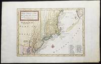
New England, New York, New Jersey, and Pensilvania &c. by H. Moll Geographer
by Moll, Herman
- Used
- near fine
- Condition
- Used - Near Fine
- Binding
- Unknown
- Quantity Available
- 1
- Seller
-
Lansdowne, Pennsylvania, United States
- Item Price
-
£375.52
Show Details
Description:
London: H. Moll, 1708. Near Fine. 1 sheet 232 x 267 mm. (image is 180 x 254 mm.) Hand-colored copper engraved map. This is Herman Moll's earliest map of New England, published in the first edition of John Oldmixon's The British Empire in North America in 1708. List of 19 towns in lower right-hand corner. New Jersey is shown as East New Jersey and West New Jersey. Pennsylvania still contains the Lower Counties, which separated and became Delaware in 1704. On the west side of the Susquehanna River is shown "The Present Sasquahana Indian Fort." In Near Fine Condition: light creasing; clean and bright.
Item Price
£375.52

More Photos
SMITH'S NEW MAP OF PHILADELPHIA AND VICINITY
by Smith, J. L.
- Used
- Hardcover
- Condition
- Used - Very Good+
- Binding
- Hardcover
- Quantity Available
- 1
- Seller
-
Fairfield, New Jersey, United States
- Item Price
-
£226.60
Show Details
Description:
Philadelphia: J. L. Smith. Very Good+. 1898. Hardcover. One large map Issued in two separate sheets; each 23" x 27 1/2". The folding maps are backed on linen. The maps are mounted in a green cloth hardcover folder with bright glit title on front. Pennsylvania; Thin 12mo 7" - 7½" tall .
Item Price
£226.60
![Southern Regions; [Published in Colton's General Atlas, 1861 as No. XIII]](https://d3525k1ryd2155.cloudfront.net/h/589/126/1453126589.0.m.jpg)
More Photos
Southern Regions; [Published in Colton's General Atlas, 1861 as No. XIII]
by Colton, George
- Used
- very good
- first
- Condition
- Used - Very Good
- Edition
- First State, later printing
- Binding
- Unknown
- Quantity Available
- 1
- Seller
-
Sebastopol, California, United States
- Item Price
-
£135.96
Show Details
Description:
New York: J. H. Colton & Co, 1855. First State, later printing. Very Good. [14x11in Neatline, 17.5x14.25in Sheet]; Map with distinctive Colton borders of discovered Antarctic features of few land features and the ice covered coast line as of 1855 from reports of explorers; Some age-toning and light stains along edges [Rumsey Collection 2441.009]. The Southern Regions map was initially drawn and engraved for publication in Colton's General Atlas of 1855. Colton reissued atlases in different formats, pagination and collation over the years. This map was from the 1861 issue and distinctive in the roman numerals format and number placement. The map has not been altered since 1855. The details on the map are from six explorations over a 70 year period from 1773 to 1843. The continent of Antarctica was completely unknown prior to James Cook's second voyage of the Resolution and Adventure 1772-1775. Others followed fifty years later Bellinghausen, 1820, Briscoe 1831-32, Kemp 1833, Wilkes 1940, and Ross…
Read More Item Price
£135.96
More Photos
Russia in Europe [map]
by Stackhouse, Thomas
- Used
- Fine
- Condition
- Used - Fine
- Binding
- Unknown
- Quantity Available
- 1
- Seller
-
Lansdowne, Pennsylvania, United States
- Item Price
-
£125.44
Show Details
Description:
London: T. Stackhouse, 1783. Map. Fine. Matted hand-colored copper engraving. Image size: 14.5 x 15.25 inches. Mat size: 22.75 x 23.75 inches. A beautiful example of this map of Eastern Europe showing the jurisdictions (as titled on the map) of Moscow, Woronesk, Bielgorod, Kiow, Smolensk, Novogorod, Nisi Nowogorod, Penzinskoi, Alatyrskoi, Galicoskoi, Chlynowskoi, Solkamskoi, Kaygorodskoi, Soli Wyczegokkoi, Jarenskoi, Peczora, Mezeskoi, Archangel, Carelia, the Kingdom of Kazan, and Russian Lapland, as well as parts of Poland, Ukrain, Livonia, Lithuania, Finland, and Siberia. In Fine Condition: clean and bright.
Item Price
£125.44
More Photos
Les Isles Britanniques [map]
by Brion de La Tour, Louis
- Used
- Fine
- Condition
- Used - Fine
- Binding
- Unknown
- Quantity Available
- 1
- Seller
-
Lansdowne, Pennsylvania, United States
- Item Price
-
£166.72
Show Details
Description:
Paris: Desnos, 1766. Map. Fine. Matted hand-colored copper engraving. Image size: 12 x 11 inches. Mat size: 17.5 x 18.5 inches. From de La Tour's Atlas Géneral, Civil et Ecclésiastique. This map can be found in several formats: with or without the separately printed decorative border, and with or without the text. This copy has the border; it does not include the text sometimes found adjacent to the map. In Fine Condition: clean and bright.
Item Price
£166.72
More Photos
New England, New York, New Jersey, and Pensilvania &c. by H. Moll Geographer
by Moll, Herman
- Used
- near fine
- Condition
- Used - Near Fine
- Binding
- Unknown
- Quantity Available
- 1
- Seller
-
Lansdowne, Pennsylvania, United States
- Item Price
-
£375.52
Show Details
Description:
London: H. Moll, 1708. Near Fine. 1 sheet 232 x 267 mm. (image is 180 x 254 mm.) Hand-colored copper engraved map. This is Herman Moll's earliest map of New England, published in the first edition of John Oldmixon's The British Empire in North America in 1708. List of 19 towns in lower right-hand corner. New Jersey is shown as East New Jersey and West New Jersey. Pennsylvania still contains the Lower Counties, which separated and became Delaware in 1704. On the west side of the Susquehanna River is shown "The Present Sasquahana Indian Fort." In Near Fine Condition: light creasing; clean and bright.
Item Price
£375.52

More Photos
Arab navigation in the Indian Ocean before the coming of the Portuguese
by Ahmad ibn Majid al-Sadi , G.R. Tibbetts
- Used
- Hardcover
- first
- Condition
- Very Good: Cover some light shelf wear, inside as new
- Edition
- First Edition
- Binding
- Hardcover
- ISBN 10 / ISBN 13
- 9780718909000 / 0718909003
- Quantity Available
- 1
- Seller
-
Berg en dal, Netherlands
- Item Price
-
£208.22
Show Details
Description:
Ahmad ibn Majid al-Sadi, G.R. Tibbetts - Arab Navigation in the Indian Ocean before the coming of the Portuguese - London, The Royal Asiatic Society of Great Britain and Ireland; Luzac and Company Ltd, 1971 - First Edition - Hardcover - 614pp + 4 maps (out of 7)- 22x14 cmCondition Very Good: Cover some light shelf wear, inside as new. Four out of seven maps present: Chart of the Arabian Sea, India and the Bay of Bengal, Red Sea and Gulf of Eden, East African CoastIf you have any questions or want to see more pictures, feel free to ask.Your book will be securely packed and shipped with tracking number, signed & insured.
Item Price
£208.22

More Photos
1875 ILLINOIS CENTRAL MAP.: Map of the Illinois Central Railroad and its Connections.
- Used
- Condition
- Used
- Quantity Available
- 1
- Seller
-
Houston, Texas, United States
- Item Price
-
£238.74
Show Details
Description:
[Railroad] Map of the Illinois Central Railroad and its Connections. Chicago: Rand McNally and Company Map Engravers. 1875. Map printed on green paper. 33 x 25 on sheet 40 x 38 cm folded to 9 x 19 cm. Added text printed in green in margins around map. One three inch fold split, else very good.OCLC shows one holding (Newberry Lib.) Relief shown by hachures. Timetables on verso "corrected to June 20th, 1875." Text describing routes and connections on 5 panels on verso: Illinois Central Railroad principal connections -- Illinois Central Railroad Dubuque and Sioux City Line! -- Illinois Central Railroad, the direct route from Chicago to Springfield, Farmer City, Clinton and Mt. Pulaski -- Illinois Central Railroad St. Louis through line -- Illinois Central Railroad New Orleans through line.
Item Price
£238.74

Scott, Foresman Spelling TURTLE, D'Nealian
by Linda Ward Beech; James Beers; Ronald L Cramer; W Dorsey Hammond; Lida F Lim; Patricia Muncy; Jr John Prejza; DeWayne Triplett
- Used
- good
- Hardcover
- Condition
- Used - Good
- Binding
- Hardcover
- ISBN 10 / ISBN 13
- 9780673277091 / 0673277097
- Quantity Available
- 1
- Seller
-
HOUSTON, Texas, United States
- Item Price
-
£10.57
Show Details
Description:
Scott, Foresman, 1988. Hardcover. Good.
Item Price
£10.57
AAPG Research Committee, 1946-1947 Reports on Projects. A Coordinated Program of Fundamental Research In Sedimentology, INCLUDES Clay Minerals; Evolution Hydrocarbons; Formation Water; Bacteria; Recent Sediments; Ancient Sediments; Carbonate Reservoirs;
by Lowman, Shepard W. ( chairman), R. F. Beers, F. M. Van Tuyl, L. G. Case, C. E. Zobell, W. C. Krumbein, W. C. Imbt, W. M. Waldschmidt, R. Balk, P. B. King, L. L. Nettleton and G. E. Archie
- Used
- good
- Paperback
- Condition
- Used - Good
- Binding
- Paperback
- Quantity Available
- 1
- Seller
-
Stephenville, Texas, United States
- Item Price
-
£12.10
Show Details
Description:
AAPG, 1947, 179 Pp. , 1947. Softcovers; ex-library; minor shelfwear w/ light creasing of corners of wraps and leaves; small splits in cloth tape at head and tail of spine; light soiling of wraps and edges; o/w in good condition ( ALSO INCLUDES Cementation; Salt Flowage; Faulting; Experimental Tectonics; Bore Hole Logging). . Soft Cover. Good.
Item Price
£12.10

Stock Photo: Cover May Be Different
Atlas of Franklin and Grand Isle Counties, Vermont.
by F W (Frederick W ) Beers
- New
- Paperback
- Condition
- New
- Binding
- Paperback
- ISBN 10 / ISBN 13
- 9781014852649 / 1014852641
- Quantity Available
- 10
- Seller
-
Southport, Merseyside, United Kingdom
- Item Price
-
£12.99
Show Details
Description:
Paperback / softback. New.
Item Price
£12.99

Battle Creek Downtown Calhoun County Michigan 1873 Map
by F. W. Beers
- Used
- very good
- first
- Condition
- Used - Very Good
- Edition
- 1st Edition
- Quantity Available
- 1
- Seller
-
Hartland, Michigan, United States
- Item Price
-
£20.23
Show Details
Description:
F. W. Beers. Very Good. 1873. 1st Edition. Map. An original map of downtown Battle Creek in Calhoun County, Michigan measuring approximately 12-1/2 x 15-1/2” at the outer edges. This map is part of the 1873 Atlas of Calhoun County Michigan published by F. W. Beers. In very good condition with light edge wear. Includes local business notices. Suitable for framing and shipped in protective covering in sturdy cardboard tube. ; MCM00399; Folio 13" - 23" tall .
Item Price
£20.23
1869 Atlas of Delaware County, New York
by Beers, F. W.; Prindle, A. B
- Used
- good
- Paperback
- Condition
- Used - Good
- Edition
- reprint
- Binding
- Paperback
- Quantity Available
- 1
- Seller
-
West Columbia, South Carolina, United States
- Item Price
-
£20.23
Show Details
Description:
Molly Yes Press, 1981. reprint. Paperback. Good. 0x0x0. 1981 reprint. Paper softcover has wear at edges and a few small marks and stains. Taped spine has small tears at lower edge. Binding is good. 41 pages, oversized. LO
Item Price
£20.23
Gazetter and Biographical Record of Genesee County, N. Y. 1788 - 1890 First Part
by Beers, F. W. Edited By
- Used
- Hardcover
- Condition
- Used - Poor with no dust jacket
- Binding
- Hardcover
- Quantity Available
- 1
- Seller
-
Washburn, Wisconsin, United States
- Item Price
-
£20.23
Show Details
Description:
Syracuse NY: J. W. Vose & Co Publishers, 1890. Hardcover. Poor with no dust jacket. Ex-library copy rebound. label removed from spine, bookplate on inside front cover, typical stamps etc. map intact (but taped in and repaired). perforated library stamp at lower part of title page, several loose pages. Reference copy only. Priority and international shipping will be extra, please inquire. ; Ex Library; 6 1/4 x 9 3/8
Item Price
£20.23

Stock Photo: Cover May Be Different
Atlas of Windsor Co. Vermont / From Actual Surveys by and Under the Direction of F.W. Beers --
by F W (Frederick W ) 1n Beers
- New
- Paperback
- Condition
- New
- Binding
- Paperback
- ISBN 10 / ISBN 13
- 9781013757006 / 1013757009
- Quantity Available
- 10
- Seller
-
Southport, Merseyside, United Kingdom
- Item Price
-
£14.27
Show Details
Description:
Paperback / softback. New.
Item Price
£14.27

Atlas of the Counties of Lamoille and Orleans, Vermont
by F. W. Beers
- New
- Condition
- New
- ISBN 10 / ISBN 13
- 9783743304536 / 3743304538
- Quantity Available
- 541
- Seller
-
Uxbridge, Greater London, United Kingdom
- Item Price
-
£17.14
Show Details
Description:
New. New Book; Fast Shipping from UK; Not signed; Not First Edition; The Atlas of the Counties of Lamoille and Orleans, Vermont.
Item Price
£17.14

Stock Photo: Cover May Be Different
Atlas of Kalamazoo Co., Michigan
by F W (Frederick W ) Beers
- New
- Paperback
- Condition
- New
- Binding
- Paperback
- ISBN 10 / ISBN 13
- 9781014025876 / 1014025877
- Quantity Available
- 10
- Seller
-
Southport, Merseyside, United Kingdom
- Item Price
-
£15.21
Show Details
Description:
Paperback / softback. New.
Item Price
£15.21

Stock Photo: Cover May Be Different
Atlas of Ionia Co., Mich.
by F W (Frederick W ) Beers
- New
- Paperback
- Condition
- New
- Binding
- Paperback
- ISBN 10 / ISBN 13
- 9781015274136 / 1015274137
- Quantity Available
- 10
- Seller
-
Southport, Merseyside, United Kingdom
- Item Price
-
£15.21
Show Details
Description:
Paperback / softback. New.
Item Price
£15.21

More Photos
The Sky and the Forest
by Forester, C.S
- Used
- very good
- Hardcover
- first
- Condition
- Used - Very Good
- Jacket Condition
- Very Good
- Edition
- First Edition
- Binding
- Hardcover
- Quantity Available
- 1
- Seller
-
Salem, Oregon, United States
- Item Price
-
£28.24£16.94Save £13.96!
Show Details
Description:
C.S. Forester: The Sky and the Forest. Little, Brown and Company, Boston. Stated First Edition First Printing Thus August, 1948. Cover price $2.75. Used. VG BOOK/VG UNCLIPPED DUST JACKET. A story of a central Africa. By C.S. Forester, author of the Admiral Hornblower series.
Item Price
£28.24£16.94
Save £13.96
!
![Alaska and Klondike Region; [With inset of Klondike Region on the Upper Yukon detail] [From an...](https://d3525k1ryd2155.cloudfront.net/h/062/537/1339537062.0.m.jpg)
Alaska and Klondike Region; [With inset of Klondike Region on the Upper Yukon detail] [From an atlas, "Gazetteer of Alaska and Yukon Region " pp. 105 and 106]
by Miller, J. Martin
- Used
- very good
- Condition
- Used - Very Good
- Edition
- Unknown
- Quantity Available
- 1
- Seller
-
Sebastopol, California, United States
- Item Price
-
£31.56
Show Details
Description:
Chicago: J. Martin Miller, 1899. Unknown. Map. Very Good. [Map copyright 1899, printing date of Atlas later] [19.875x15.125in]; Colored map of Alaska with steamer routes from Portland and Seattle, insets of the Klondike Region on the Upper Yukon and Western portion of Aleutian Islands; On verso index of places and names with two large black and white images; Age toning to all edges, water stain marks on bottom, slight printing offset of colors, small chips and closed tears to lower edge;.
Item Price
£31.56

Zemepis Sveta - Monsunova Asie
by De La Blache, P. Vidal; Gallois, L
- Used
- Hardcover
- Condition
- Used - Very Good Condition
- Jacket Condition
- No Dust Jacket
- Binding
- Hardcover
- Quantity Available
- 1
- Seller
-
Oak Point, Texas, United States
- Item Price
-
£48.56
Show Details
Description:
Aventinum, Prague, Czechoslovakia, 1930. Hardcover. Very Good Condition/No Dust Jacket. Text entirely in Czech. Geography book on Asia with numerous photographs and maps. 1931 edition also available. Size: 4mo - over 9 3/4" - 12" tall. 400 pp. Pages are yellowed, but are tight and clean. Moderate shelfwear along the spine. Corners are lightly bumped. Quantity Available: 1. Shipped Weight: 3-5 pounds. Category: Travel & Places; Non-English Language::Czech; Pictures of this item not already displayed here available upon request. Inventory No: 001227. . Additional shipping charges may apply.
Item Price
£48.56

Zemepis Sveta - Monsunova Asie
by De La Blache, P. Vidal; Gallois, L
- Used
- Hardcover
- Condition
- Used - Very Good Condition
- Jacket Condition
- No Dust Jacket
- Binding
- Hardcover
- Quantity Available
- 1
- Seller
-
Oak Point, Texas, United States
- Item Price
-
£48.56
Show Details
Description:
Aventinum, Prague, Czechoslovakia, 1931. Hardcover. Very Good Condition/No Dust Jacket. Text entirely in Czech. Geography book on Asia with numerous photographs and maps. 1930 edition also available. Size: 4mo - over 9 3/4" - 12" tall. 400 pp. Pages are yellowed, but are tight and clean. Moderate shelfwear along the spine. Corners are lightly bumped. Quantity Available: 1. Shipped Weight: 3-5 pounds. Category: Travel & Places; Non-English Language::Czech; Pictures of this item not already displayed here available upon request. Inventory No: 001228. . Additional shipping charges may apply.
Item Price
£48.56

Asia from the Best Authorities, Russell, ca.1800
by Russell
- Used
- Condition
- Used
- Quantity Available
- 1
- Seller
-
Plymouth, Devon, United Kingdom
- Item Price
-
£20.00
Show Details
Description:
Russell, J. : Asia from the Best Authorities. Nd but ca.1800. From "A New Geographical, Historical and Commercial Grammar and Present State of Several Kingdoms of the World". Copper engraving. Size approx 200 x 230mm. Two neat folds. Some age colouring to edges, otherwise clean and bright. Includes Arabia, India, Borneo, Japan, China and eastern Russia.
Item Price
£20.00

North America from the Best Authorities, Russell, ca.1800
by Russell
- Used
- Condition
- Used
- Quantity Available
- 1
- Seller
-
Plymouth, Devon, United Kingdom
- Item Price
-
£20.00
Show Details
Description:
Russell, J. : A General Map of North America from the Best Authorities. Nd but ca.1800. From "A New Geographical, Historical and Commercial Grammar and Present State of Several Kingdoms of the World." Copper engraving. Size approx 200 x 230mm. Two neat folds. Some age colouring to edges, otherwise very clean and bright.
Item Price
£20.00
![MAP OF UTAH [Territory]](https://d3525k1ryd2155.cloudfront.net/h/836/461/1485461836.0.m.jpg)
More Photos
MAP OF UTAH [Territory]
- Used
- Condition
- Used - Very Good-
- Edition
- Original
- Quantity Available
- 1
- Seller
-
Williamsburg, Virginia, United States
- Item Price
-
£52.60
Show Details
Description:
New York, Richmond, Chicago, & Toledo: H. H. Hardesty, 1885. Original color lithographed map printed by Rand, McNally & Company, Engravers and published in HARDESTY'S HISTORICAL AND GEOGRAPHICAL ENCYCLOPEDIA: SPECIAL VIRGINIA EDITION. 19 3/8 inches by 13 1/4 inches on a 21" X 14 1/2" sheet. The map depicts the Territory of Utah in its final form--large areas had been removed and ceded to Nevada, Colorado, Wyoming, and Nebraska since Utah became a U. S. Territory in 1850. The issue of polygamy prevented statehood until it was finally granted in 1896. This map features railroads and topography and uses color to set off counties from each other. Unlike most atlas maps of the period, this map identifies most small towns. The map is guaranteed to be moe than 135 years old. The map is in about very good condition: generally clean and bright, with slight toning of paper and one faint water stain near the center-left edge of the map.. Original. Single Sheet. Very Good-. Elephant…
Read More Item Price
£52.60

Philips Special Map of the Nile, The Advance on Khartum and the Environs of Omdurman. Cc1900
by George Philips and Son,
- Used
- Condition
- Used
- Quantity Available
- 1
- Seller
-
Plymouth, Devon, United Kingdom
- Item Price
-
£26.00
Show Details
Description:
Philips Special map of the Nile illustrating the Advance on Khartum [Khartoum] with an enlargement of the environs of Omdurman [Omdur]. George Philips and Son, London and Liverpool Ca 1900. 580mm x 900mm folded map. Front title wrapper has come loose, not affecting map area. Three maps are displayed within the sheet. Map1. Map of the Nile Valley 520mm x 300mm showing the approaches of Khartum. Scale 1inch to 100 Geographical miles. Coloured indicating Possessions and Protectorates of European Powers. Map 2. Special map of the Nile from Dongola to Khartum. Scale 16 miles to the inch. Coloured. In set in this map is Map3. Environs of Omdurman, Scale 5 statute miles to the inch. Some small breaks at some folds, not affecting imagery or use of map. Title label is damaged, the map is clean and bright, probably unused. A very interesting record.
Item Price
£26.00

Last Tales
by Dinesen, Isak
- Used
- very good
- Hardcover
- first
- Condition
- Used - Very Good
- Jacket Condition
- Good+
- Edition
- First Edition
- Binding
- Hardcover
- Quantity Available
- 1
- Seller
-
Salem, Oregon, United States
- Item Price
-
£97.12£58.27Save £48.00!
Show Details
Description:
Dinesen, Isak: Last Tales, A Collection of Twelve New Tales of Compelling Beauty 1957, Random House. First Edition. Stated First Printing Thus. Used. Very Good/Good+ original red dust jacket, price-clipped. Jacket states 11/57 on front flap. 5 3/4 X
Item Price
£97.12£58.27
Save £48.00
!

The Adventure of Wrangel Island
by Vilhjalmur Stefansson
- Used
- good
- Hardcover
- first
- Condition
- Used - Good
- Jacket Condition
- No DJ Included
- Edition
- First Edition
- Binding
- Hardcover
- Quantity Available
- 1
- Seller
-
Salem, Oregon, United States
- Item Price
-
£101.07£60.64Save £49.96!
Show Details
Description:
The Adventure of Wrangel Island, Alaska (1925 Macmillan 1st Edition) HISTORY OF ALASKA. EXLIB. Good Condition/ No DJ included. Fold-out map affixed to binding at the back of the book has never been opened. The story of the (unsuccessful) attempted colonization of Wrangel Island Alaska. 413 pages plus appendix, Index. Titling is still bright. A clean, solid copy. Scarce.
Item Price
£101.07£60.64
Save £49.96
!