Description:
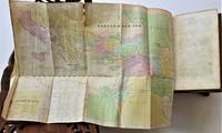
New York and Chicago: Ivison, Blakeman, Taylor & Company, 1885. RARE, Worldcat lists only one institutional holding . Contains 22 two-page maps of ancient countries and empires plus 30 pp. Index with latitudes and longitudes of nearly 10,000 places. Near Fine, small number in ink top corner front paste down, light rubbing to cloth at tips. Maps include Orbis Veteribus Notus, Romanum Imperium, Hispania, Gallia, Asia Minor, Syria, Aegyptus, Africa et Libya, etc. . First Edition. Cloth. Near Fine/No Jacket, As Issued. 8vo - over 7¾" - 9¾" tall.
Bowen's Indiana State Atlas; Containing A Separate Maps Of Each County, Showing Section, Township And Range Lines ... Also Containing Maps Of Indiana, The United States And The World ... -
Bowen's Indiana State Atlas; containing a separate maps of each county, showing section, township and range lines ... also containing maps of Indiana, the United States and the world ...
- Used
- very good
- Hardcover
- first
Indianapolis, IN: B. F. Bowen & Co., Inc., 1917. SCARCE. Title continues -"containing a separate map of each county, showing section, township and range lines, railroad and interurban lines, churches and school houses and public highways, with a historical sketch of each county ; improved roads shown in colors ; also containing maps of Indiana, the United States and the world ; population of counties, townships, incorporated cities and towns, with estimated population for 1920 ; geographical and other tables ; a history of the growth of the state, and an explanation of the system of land surveys." 15 1/2" x 12", 220 pages.Bound in original black cloth, about Very Good, hinges reinforced with green library tape but still starting to open and a bit loose, cloth rubbed at edges, marginal dampstain along bottom edge, not affecting maps. All maps present and colors bright, Prior owner small name sticker front paste down, 2 page world map at rear with more dampstaining. . First Edition. Cloth. Very Good. Elephant Folio - over 15" - 23" tall.
-
Bookseller
Dale Steffey Books, ABAA
 (US)
(US)
- Format/Binding Hardcover
- Book Condition Used - Very Good
- Edition First Edition
- Binding Hardcover
- Publisher B. F. Bowen & Co., Inc.
- Place of Publication Indianapolis, IN
- Date Published 1917
- Size Elephant Folio - over 15" -
- Size Elephant Folio - over 15" - 23" tall
More Photos
Standard Classic Atlas for Schools and Colleges with an Alphabetical Index Giving the Latitudes and Longitudes of Nearly 10,000 Places
- Used
- near fine
- Hardcover
- first
- Condition
- Used - Near Fine
- Jacket Condition
- No Jacket, As Issued
- Edition
- First Edition
- Binding
- Hardcover
- Quantity Available
- 1
- Seller
-
Bloomington, Indiana, United States
- Item Price
-
£323.36
Show Details
Item Price
£323.36
More Photos
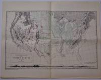
A Physiographic Diagram of the United States, (Small Scale Edition). Map with Accompanying Text
by Lobeck, A. K.
- Used
- near fine
- Paperback
- Condition
- Used - Near Fine
- Jacket Condition
- No Jacket, As Issued
- Edition
- 18th Printing
- Binding
- Paperback
- Quantity Available
- 1
- Seller
-
Bloomington, Indiana, United States
- Item Price
-
£202.10
Show Details
Description:
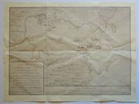
New York: The Geographical Press, Columbia University, 1950. SCARCE. 8 pp,, 6 with text and 2 page map printed verso pages 1 and 8, 19" h x 12" w closed, map 19" h x 24" w open. Near Fine, centerfold as issued, prior owner name top edge front page, light foxing bottom margin front page with text. Scale 1/9,000,000 or about 150 miles to 1 inch. . 18th Printing. Map. Near Fine/No Jacket, As Issued. 19" h x 24 " W.
Item Price
£202.10
More Photos
Drummond's Pictorial Atlas of North Carolina
by Drummond, Albert Y. (editor)
- Used
- near fine
- Hardcover
- Signed
- first
- Condition
- Used - Near Fine
- Jacket Condition
- No Jacket, As Issued
- Edition
- First Edition
- Binding
- Hardcover
- Quantity Available
- 1
- Seller
-
Bloomington, Indiana, United States
- Item Price
-
£485.04
Show Details
Description:
Charlotte, NC: Albert Y. Drummond, 1924. Presentation Copy, SIGNED AND INSCRIBED BY AUTHOR, editor and publisher Albert Y. Drummond at front end page -" Joseph Hyde Pratt with the compliments of the author. Oct. 1924". SCARCE Association Copy, Col. Joseph Hyde Pratt (1870-1942) was a prominent North Carolina geologist, conservationist, and state and civic leader. In W.W, I he was the colonel in command of the First Battalion of the 105th Engineers, and was part of the famous Thirtieth "Old Hickory" Division, the first to break the Hindenburg Line.(NCpedia). In presentation embossed crushed morocco binding, Near Fine, morocco a bit rubbed, two pages of typed recommendations tipped at rear paste down. Profusely illustrated with black and white photographs, 148 pages. SCARCE in current commerce. . SIGNED AND INSCRIBED BY AUTHOR. First Edition. Crushed Morocco. Near Fine/No Jacket, As Issued. Folio - over 12" - 15" tall. Presentation Copy.
Item Price
£485.04

More Photos
Geographia Map Company's The Premier Street Map of Buffalo (NY) House Numbers - Transit Lines - Postal Zones - Street Index, Etc.
by Gross, Alexander, F.R.G.S.,under the direction of
- Used
- very good
- Paperback
- Condition
- Used - Very Good
- Binding
- Paperback
- Quantity Available
- 1
- Seller
-
Bloomington, Indiana, United States
- Item Price
-
£161.68
Show Details
Description:
New York: Geographia Map Company, Inc. No date, 2 digit zip code dates from 1943-1963, Worldcat lists this map 195?. Large folded map in attached protective folder, 9 1/2" x 4 1/2" , map opens to 40 1/4" x 26 3/4". Full color. Printed one side only. Includes index and inset of Niagara Falls and vicinity (10 1/4" x 7 1/8"). Scale [ca. 1:30,000]. Very Good folder, rubbed and with small creases and light edge wear. Map is Near Fine, light toning, no tears, well suited for framing. . Folded Map. Very Good. 9 1/2" x 4 1/2".
Item Price
£161.68
More Photos
An Epitome of General Ecclesiastical History, from the Earliest Period to the Present Time. With an Appendix, Giving a Condensed History of the Jews
by Marsh, Rev. John
- Used
- Hardcover
- Condition
- Used - Very Good Minus
- Edition
- Eighth Edition
- Binding
- Hardcover
- Quantity Available
- 1
- Seller
-
Bloomington, Indiana, United States
- Item Price
-
£485.04
Show Details
Description:
New York: J. Tilden and Co., 1844. SCARCE with both folding maps at front and folding chart present and in Very Good condition. Bound in contemporary full calf, gilt back, marbled edges. Very Good Minus, boards rubbed, hinges starting yet holding well, 1/8" loss of calf at head of spine, moderate toning throughout, prior owner name in ink. Large map at front hand colored, small tears and creases, light toning, 2nd map with 1 small tear, light toning, folding chart at rear with chip to fore edge margin, light toning and creasing. 462 pages, illustrated title page with portrait frontis, followed by 6 engraved plates. . Eighth Edition. Calf. Very Good Minus. 8vo - over 7¾" - 9¾" tall.
Item Price
£485.04
More Photos
Standard Classic Atlas for Schools and Colleges with an Alphabetical Index Giving the Latitudes and Longitudes of Nearly 10,000 Places
- Used
- near fine
- Hardcover
- first
- Condition
- Used - Near Fine
- Jacket Condition
- No Jacket, As Issued
- Edition
- First Edition
- Binding
- Hardcover
- Quantity Available
- 1
- Seller
-
Bloomington, Indiana, United States
- Item Price
-
£323.36
Show Details
Description:
New York and Chicago: Ivison, Blakeman, Taylor & Company, 1885. RARE, Worldcat lists only one institutional holding . Contains 22 two-page maps of ancient countries and empires plus 30 pp. Index with latitudes and longitudes of nearly 10,000 places. Near Fine, small number in ink top corner front paste down, light rubbing to cloth at tips. Maps include Orbis Veteribus Notus, Romanum Imperium, Hispania, Gallia, Asia Minor, Syria, Aegyptus, Africa et Libya, etc. . First Edition. Cloth. Near Fine/No Jacket, As Issued. 8vo - over 7¾" - 9¾" tall.
Item Price
£323.36
Reproduction Map) Plan of the Harbour, Town & Forts of Porto Bello
- Used
- near fine
- Paperback
- Condition
- Used - Near Fine
- Edition
- Reprint
- Binding
- Paperback
- Quantity Available
- 1
- Seller
-
Bloomington, Indiana, United States
- Item Price
-
£80.84
Show Details
Description:
No Place: No Publisher Bottom right states " By permission of the British Library", Map Number 83670, (2), Plan of the Harbour, Town & Forts of Porto Bello. Near Fine, folded once horizontally, twice vertically. The greatest British success in the War of Jenkin's Ear, fought against the Spanish. Nicely suited for framing, will be mailed folded. . Reprint. Map. Near Fine. 24 3/4" w x 18 3/4" h.
Item Price
£80.84
More Photos
De Situ Orbis Libri III cum notis integris Hermolai Barbari, Petri Joannis Olivarii, Fredenandi Nonii Pintiani, Petri Ciacconii, Andreae Schotti, Isaaci Vossii, et Jacobi Gronovii. Accedunt Petri Joannis Nunnesii. et Jacobi Perizonii.cur. Abrahamo Gronovi
by Pomponii Melae
- Used
- very good
- Hardcover
- Condition
- Used - Very Good
- Jacket Condition
- No Jacket, As Issued
- Edition
- Editio Altera ( Second Edition)
- Binding
- Hardcover
- Quantity Available
- 1
- Seller
-
Bloomington, Indiana, United States
- Item Price
-
£687.14
Show Details
Description:
Lugduni Batavorum (London): Samuelem Luchtmans et Fil, 1748. Two volumes in contemporary full vellum, Illustrated with allegorical frontispiece engraving and folding engraved map of the known earth in classical times, with numerous copperplate engravings in the text. Title page of V. 2 reads: ..." Pars altera exhibens animadversiones Isaaci Vossii, Jacobi Perizonii, et Abrahami Gronovii, ac dedicationes & praefationes virorum doctorum, atque vitam Fredenandi Nonii Pintiani ab Andrea Schotto descriptam, & quatuor indices ..." (20), 546, (4), 547-1081, (55) pp. The only ancient treatise on geography in classical Latin, written roughly 43 or 44 CE, and remaining in use until around 1500. Very Good. both volumes moderately toned, vellum soiled, map and frontispiece engraving are Fine, small holes top corner first 6 pages Vol. 1 and top corner front end page Vol. 2. A quite handsome and well bound copy of this SCARCE edition in contemporary vellum binding. . Editio Altera (…
Read More Item Price
£687.14
More Photos
Drummond's Pictorial Atlas of North Carolina
by Drummond, Albert Y. (editor)
- Used
- near fine
- Hardcover
- Signed
- first
- Condition
- Used - Near Fine
- Jacket Condition
- No Jacket, As Issued
- Edition
- First Edition
- Binding
- Hardcover
- Quantity Available
- 1
- Seller
-
Bloomington, Indiana, United States
- Item Price
-
£485.04
Show Details
Description:
Charlotte, NC: Albert Y. Drummond, 1924. Presentation Copy, SIGNED AND INSCRIBED BY AUTHOR, editor and publisher Albert Y. Drummond at front end page -" Joseph Hyde Pratt with the compliments of the author. Oct. 1924". SCARCE Association Copy, Col. Joseph Hyde Pratt (1870-1942) was a prominent North Carolina geologist, conservationist, and state and civic leader. In W.W, I he was the colonel in command of the First Battalion of the 105th Engineers, and was part of the famous Thirtieth "Old Hickory" Division, the first to break the Hindenburg Line.(NCpedia). In presentation embossed crushed morocco binding, Near Fine, morocco a bit rubbed, two pages of typed recommendations tipped at rear paste down. Profusely illustrated with black and white photographs, 148 pages. SCARCE in current commerce. . SIGNED AND INSCRIBED BY AUTHOR. First Edition. Crushed Morocco. Near Fine/No Jacket, As Issued. Folio - over 12" - 15" tall. Presentation Copy.
Item Price
£485.04
More Photos
An Epitome of General Ecclesiastical History, from the Earliest Period to the Present Time. With an Appendix, Giving a Condensed History of the Jews
by Marsh, Rev. John
- Used
- Hardcover
- Condition
- Used - Very Good Minus
- Edition
- Eighth Edition
- Binding
- Hardcover
- Quantity Available
- 1
- Seller
-
Bloomington, Indiana, United States
- Item Price
-
£485.04
Show Details
Description:
New York: J. Tilden and Co., 1844. SCARCE with both folding maps at front and folding chart present and in Very Good condition. Bound in contemporary full calf, gilt back, marbled edges. Very Good Minus, boards rubbed, hinges starting yet holding well, 1/8" loss of calf at head of spine, moderate toning throughout, prior owner name in ink. Large map at front hand colored, small tears and creases, light toning, 2nd map with 1 small tear, light toning, folding chart at rear with chip to fore edge margin, light toning and creasing. 462 pages, illustrated title page with portrait frontis, followed by 6 engraved plates. . Eighth Edition. Calf. Very Good Minus. 8vo - over 7¾" - 9¾" tall.
Item Price
£485.04

More Photos
The Sky and the Forest
by Forester, C.S
- Used
- very good
- Hardcover
- first
- Condition
- Used - Very Good
- Jacket Condition
- Very Good
- Edition
- First Edition
- Binding
- Hardcover
- Quantity Available
- 1
- Seller
-
Salem, Oregon, United States
- Item Price
-
£28.21£14.11Save £17.44!
Show Details
Description:
C.S. Forester: The Sky and the Forest. Little, Brown and Company, Boston. Stated First Edition First Printing Thus August, 1948. Cover price $2.75. Used. VG BOOK/VG UNCLIPPED DUST JACKET. A story of a central Africa. By C.S. Forester, author of the Admiral Hornblower series.
Item Price
£28.21£14.11
Save £17.44
!

More Photos
Plat Book: Pierce County, Wisconsin
by Rhame, A. E
- Used
- Fine
- Paperback
- Condition
- Used - Fine
- Binding
- Paperback
- Quantity Available
- 1
- Seller
-
Woodruff, Wisconsin, United States
- Item Price
-
£37.72
Show Details
Description:
1930. Soft Cover. Fine. Unpaginated. Tan colored book is in Fine condition, no sign of wear.
Item Price
£37.72
![Alaska and Klondike Region; [With inset of Klondike Region on the Upper Yukon detail] [From an...](https://d3525k1ryd2155.cloudfront.net/h/062/537/1339537062.0.m.jpg)
Alaska and Klondike Region; [With inset of Klondike Region on the Upper Yukon detail] [From an atlas, "Gazetteer of Alaska and Yukon Region " pp. 105 and 106]
by Miller, J. Martin
- Used
- very good
- Condition
- Used - Very Good
- Edition
- Unknown
- Quantity Available
- 1
- Seller
-
Sebastopol, California, United States
- Item Price
-
£31.53
Show Details
Description:
Chicago: J. Martin Miller, 1899. Unknown. Map. Very Good. [Map copyright 1899, printing date of Atlas later] [19.875x15.125in]; Colored map of Alaska with steamer routes from Portland and Seattle, insets of the Klondike Region on the Upper Yukon and Western portion of Aleutian Islands; On verso index of places and names with two large black and white images; Age toning to all edges, water stain marks on bottom, slight printing offset of colors, small chips and closed tears to lower edge;.
Item Price
£31.53

Last Tales
by Dinesen, Isak
- Used
- very good
- Hardcover
- first
- Condition
- Used - Very Good
- Jacket Condition
- Good+
- Edition
- First Edition
- Binding
- Hardcover
- Quantity Available
- 1
- Seller
-
Salem, Oregon, United States
- Item Price
-
£97.01£48.50Save £60.00!
Show Details
Description:
Dinesen, Isak: Last Tales, A Collection of Twelve New Tales of Compelling Beauty 1957, Random House. First Edition. Stated First Printing Thus. Used. Very Good/Good+ original red dust jacket, price-clipped. Jacket states 11/57 on front flap. 5 3/4 X
Item Price
£97.01£48.50
Save £60.00
!

Zemepis Sveta - Monsunova Asie
by De La Blache, P. Vidal; Gallois, L
- Used
- Hardcover
- Condition
- Used - Very Good Condition
- Jacket Condition
- No Dust Jacket
- Binding
- Hardcover
- Quantity Available
- 1
- Seller
-
Oak Point, Texas, United States
- Item Price
-
£48.50
Show Details
Description:
Aventinum, Prague, Czechoslovakia, 1931. Hardcover. Very Good Condition/No Dust Jacket. Text entirely in Czech. Geography book on Asia with numerous photographs and maps. 1930 edition also available. Size: 4mo - over 9 3/4" - 12" tall. 400 pp. Pages are yellowed, but are tight and clean. Moderate shelfwear along the spine. Corners are lightly bumped. Quantity Available: 1. Shipped Weight: 3-5 pounds. Category: Travel & Places; Non-English Language::Czech; Pictures of this item not already displayed here available upon request. Inventory No: 001228. . Additional shipping charges may apply.
Item Price
£48.50

Zemepis Sveta - Monsunova Asie
by De La Blache, P. Vidal; Gallois, L
- Used
- Hardcover
- Condition
- Used - Very Good Condition
- Jacket Condition
- No Dust Jacket
- Binding
- Hardcover
- Quantity Available
- 1
- Seller
-
Oak Point, Texas, United States
- Item Price
-
£48.50
Show Details
Description:
Aventinum, Prague, Czechoslovakia, 1930. Hardcover. Very Good Condition/No Dust Jacket. Text entirely in Czech. Geography book on Asia with numerous photographs and maps. 1931 edition also available. Size: 4mo - over 9 3/4" - 12" tall. 400 pp. Pages are yellowed, but are tight and clean. Moderate shelfwear along the spine. Corners are lightly bumped. Quantity Available: 1. Shipped Weight: 3-5 pounds. Category: Travel & Places; Non-English Language::Czech; Pictures of this item not already displayed here available upon request. Inventory No: 001227. . Additional shipping charges may apply.
Item Price
£48.50

The Adventure of Wrangel Island
by Vilhjalmur Stefansson
- Used
- good
- Hardcover
- first
- Condition
- Used - Good
- Jacket Condition
- No DJ Included
- Edition
- First Edition
- Binding
- Hardcover
- Quantity Available
- 1
- Seller
-
Salem, Oregon, United States
- Item Price
-
£100.96£50.48Save £62.44!
Show Details
Description:
The Adventure of Wrangel Island, Alaska (1925 Macmillan 1st Edition) HISTORY OF ALASKA. EXLIB. Good Condition/ No DJ included. Fold-out map affixed to binding at the back of the book has never been opened. The story of the (unsuccessful) attempted colonization of Wrangel Island Alaska. 413 pages plus appendix, Index. Titling is still bright. A clean, solid copy. Scarce.
Item Price
£100.96£50.48
Save £62.44
!

Seven Pillars Of Wisdom, A Triumph
by Lawrence, T.E
- Used
- good
- Hardcover
- first
- Condition
- Used - Good
- Jacket Condition
- No DJ Included
- Edition
- First American Edition
- Binding
- Hardcover
- Quantity Available
- 1
- Seller
-
Salem, Oregon, United States
- Item Price
-
£101.01£50.51Save £62.47!
Show Details
Description:
T.E. Lawrence. SEVEN PILLARS OF WISDOM, A TRIUMPH. AUTOBIOGRAPHY. Privately Printed, 1926. First Published for general circulation 1935. First American Edition. States MCMXXXVI on the title page. Doubleday, Doran & Company, Inc. Garden City, NY. GOOD CONDITION/ NO DUST JACKET IS INCLUDED. 672 pages, indexed. Beige buckram boards. Spine has darkened a bit. 6 7/8 X 9 ½.
Item Price
£101.01£50.51
Save £62.47
!

Asia from the Best Authorities, Russell, ca.1800
by Russell
- Used
- Condition
- Used
- Quantity Available
- 1
- Seller
-
Plymouth, Devon, United Kingdom
- Item Price
-
£20.00
Show Details
Description:
Russell, J. : Asia from the Best Authorities. Nd but ca.1800. From "A New Geographical, Historical and Commercial Grammar and Present State of Several Kingdoms of the World". Copper engraving. Size approx 200 x 230mm. Two neat folds. Some age colouring to edges, otherwise clean and bright. Includes Arabia, India, Borneo, Japan, China and eastern Russia.
Item Price
£20.00

North America from the Best Authorities, Russell, ca.1800
by Russell
- Used
- Condition
- Used
- Quantity Available
- 1
- Seller
-
Plymouth, Devon, United Kingdom
- Item Price
-
£20.00
Show Details
Description:
Russell, J. : A General Map of North America from the Best Authorities. Nd but ca.1800. From "A New Geographical, Historical and Commercial Grammar and Present State of Several Kingdoms of the World." Copper engraving. Size approx 200 x 230mm. Two neat folds. Some age colouring to edges, otherwise very clean and bright.
Item Price
£20.00