Description:
Amsterdam: Schenk and Valk, 1708. Very good, minimal foxing, early color copperplate from this 1708 (original version published in 1660 by Jansson) Schenk/Valk issue of (Andreas Cellarius') "Harmonia Macrocosmica Seu Atlas Universalis Et Novus." The striking image measures 41 x 51 cm on a sheet 50 x 59 cm. Numerous cherubim surrond the eastern hemispheric view, which is also divided into frigid, termperate, tropical and torrid zones. There are separate armillary and habitat zonal spheres in the lower corners. Ref: Koeman, Atlantes Neerlandici, Cel.3. There are bilateral, faint water-stains in the pink circular band surrounding the map image..
Biblical Atlas advanced copy Karten und Kupfer Scherer by Johann Ludwig Wilhelm Scherer - 1802: Maps and copperplates to Scherer's historical introduction to understanding the Bible
by Johann Ludwig Wilhelm Scherer

Biblical Atlas advanced copy Karten und Kupfer Scherer: Maps and copperplates to Scherer's historical introduction to understanding the Bible
by Johann Ludwig Wilhelm Scherer
- Used
- Fine
- Hardcover
- first
An extraordinary collection of 24 very rare maps and engravings. Collected by Johann Ludwig Wilhelm Scherer and printed in Halle in 1802. Some of the maps don't have the publisher printed on the cartouches since this is an advanced copy intended for the publisher.
Bound in a contemporary fine leather binding. All maps are extremely scarce and some of them are without the publisher's legend, making them unique on the market.
Maps are in various dimensions, with some of them folding.
All of them are in fine condition with minimal traces of wear and aging, a few are slightly stained.
Maps are collected with the purpose of an introduction to the historical understanding of the Bible. A list of maps can be found on the first page:
1) Tafel der Altvater von der Sundfluth
2) Wahrscheinliche Lage von Eden
3) Tafel der Altvater nach der Sundfluth bis auf Abraham
4) Karte von dem alten Aegzpten und den angranzenden Landern
5) Aegypten nach dem Zuftlande der alten Zeit
6) Karte von Szrien und Phonicien
7) Karte von der Eintheilung und Situation der Gefchlecther der Cananiter, Moabiter, Ammoniter etc. vor und zur Zeit des Auszugs der Israeliten
8) Lager der Israeliten nach dem Reyher und nach dem Lamy
9) Karte von der Reife der Israeliten durch die Wuften von dem Ausgange aus Aegypten bis an den Jordan
10) Karte von einem Theile des mittellandIschen Meeres
11) Karte vom gelobten Lande
12) Grundrifs des Tempels zu Jerusalem durch den Konig-Salomo erbauet, nach Anzeige der Bucher der Konige und der Chroniken
13) Grundrifs von dem Modell des Salomonischen Tempels
14) Perspectivische Vorstellung des Temples Salomo's auf der Nordfeite nach dem Hallischen Modell und Scheuchzer
15) Vorstellung des Salomonischen Tempels von aufsen
16) Profil des Tempels Salomo's auf der Nordfeite, weiches das, was im Tempel gewefen, anzeiget
17) Grundrif der Stadt Jerusalem nach Anleitung der Bescreibung in den Buchern alten Testaments, infonderheit in dem Buche Nehemia
18) Karte von dem Konigreiche Juda und Israel
19) Die Stadt Babylon
20) Alt Griechenland, wie es zuerst in Konigreiche, dar nach in Republiken, und endlich von dern Romern in Provinzen ist abgetheilt gewefen.
21) Vorstellung des alten und neuen Athens
22) Heutiges Athen nach Mitternacht anzufehen
23) Abbildung des Tempels von der Minerva zu Athen
24) Karte von der Reise der Israeliten in der Wuften und der Eroberung und Eintheilung des Landes Canaan
-
Seller
Sigedon LTD
 (SC)
(SC)
- Format/Binding Fine leather binding with blindstamped spine cover. In perfect condition.
- Book Condition Used - Fine
- Quantity Available 1
- Binding Hardcover
- Publisher Johann Jacob Gebauer
- Place of Publication Halle
- Date Published 1802
- Pages 24 maps
- Size Folio (Fo)
- Keywords maps, bible, engravings, german
- Size Folio (Fo)

(Old World hemispheric map with climatic zones): Hemisphaerium Orbis Antiqui, Cumzonis, Circulis, Et Situ Populorum Diverso
by Valk, Gerard and Schenk, Petrus [Cellarius, Andreas]
- Used
- Condition
- Used
- Binding
- Unknown
- Quantity Available
- 1
- Seller
-
Crozet, Virginia, United States
- Item Price
-
£2,157.39
Show Details
Item Price
£2,157.39

More Photos
Catalogue des Cartes Géographiques, Topographiques & Marines, de la Bibliothèque du Prince Alexandre Labanoff de Rostoff, a Saint-Pétersbourg. Suivi d'une Notice de Manuscrits
- Used
- very good
- Hardcover
- first
- Condition
- Used - Very Good
- Edition
- 1st Edition
- Binding
- Hardcover
- Quantity Available
- 1
- Seller
-
Kraków, Poland
- Item Price
-
£1,913.30
Show Details
Description:
Paris: Firmin Didot, 1823 8vo (20 x 13.2 cm), VIII, 494, [2] pp, half chagrin over marbled boards, with original wrappers bound in (slightly foxed, blind collector stamps on the title and the first page). This is the catalog of the map collection of Duke Aleksandr Lobanov-Rostovsky (1788-1866), a Russian general and diplomat. The catalog was authored by the Duke himself, with assistance from Charles Piquet. This edition is one of the 230 copies privately printed by Firmin Didot.
Item Price
£1,913.30

More Photos
L’Utrecht suivant les nouvelles observations de Messrs. de l’Academie des Sciences etc. Augmentées de nouveau.
by Covens, Johannes et Cornelis Mortier
- Used
- Condition
- Used
- Quantity Available
- 1
- Seller
-
Tuebingen, Germany
- Item Price
-
£1,959.08
Show Details
Description:
Engraved and partially hand-coloured map with nice figurative cartouche mounted on wood, backside lined with blue paste paper with impressed decoration (= complete). Oblong folio (300 x 223 mm). All pieces loosely contained in contemporary wooden box with a sliding lid with manuscript title "Utrecht" on top. A very early example of this kind of game, and hard to find complete and in very good overall condition.
Item Price
£1,959.08

More Photos
Britannicae Insulae: Antique map of Great Britain
by Robert de Vaugondy
- Used
- very good
- Condition
- Used - Very Good
- Quantity Available
- 1
- Seller
-
Providence, Seychelles
- Item Price
-
£141.14
Show Details
Description:
FULL TITLE: Britannicae, Insulae in quibus Albion Seu Britannia Major, et Ivernia seu Britannia Minor juxta Ptolemaei mentem divisae tùm in suas majores partes, tùm in populos exhibentur, à Nicolao sanson Christ, Regis Geographo, Revisae, et ad observationes astronomicas redactae, accurante Robert de Vaugondy filio, gum Privilegio Regis'DATE PRINTED: 1750 IMAGE SIZE: Approx 50.0 x 55.0cm, 19.5 x 21.5 inches (Large); Please note that this is a folding map.TYPE: Large antique 18th-century atlas map, printed on thick, good quality paper. partially hand-colored.CONDITION: Good; suitable for framing. Please check the scan for any blemishes prior to making your purchase. Virtually all antiquarian maps and prints are subject to some normal aging due to use and time which is not obtrusive unless otherwise stated. We offer a no-questions-asked return policy.AUTHENTICITY: This is an authentic historic map, published at the date stated above. It is not a modern copy.VERSO: Short map title printed on the…
Read More Item Price
£141.14

More Photos
Mediterranean, the Dardanelles (ancient Hellespont): Nautical map of the Dardanelles
by Hydrographic Office of Great Britain
- Used
- Condition
- Used - Good-
- Edition
- Large corrections Sept. 1880. Small corrections to 1914.
- Quantity Available
- 1
- Seller
-
Providence, Seychelles
- Item Price
-
£141.14
Show Details
Description:
Hydrographic chart of the Dardanelles Strait region, Turkey. Relief is shown by spot heights and hachures. Depths are shown by bathymetric isolines and soundings.The chart is damaged along the edges with some tears in the middle. Wrinkles and some pencil inscriptions, signs of aging and wear. Please see the photos. Free Shipping included. The map will be shipped in a strong cardboard tube.If you have any questions or inquiries, please don't hesitate to contact us!
Item Price
£141.14

More Photos
Philippi Cluverii Introductio in universam geographiam tam veterem quam novam. Tabulis geographicis XLVI ac notis olim ornata a Johanne Bunone, jam vero locupletata additamentis & annotationibus Joh. Frid. Hekelii & Joh. Reiskii. Cum privilegio ordinum Ho
by Clüver, Philippe [Philipp Cluverius / Cluvier] - Buno, Johann ; Reiske, Johann ; Heckel, Johann Friedrich
- Used
- Hardcover
- first
- Condition
- Used - Bon
- Edition
- First Thus
- Binding
- Hardcover
- Quantity Available
- 1
- Seller
-
Paris, France
- Item Price
-
£1,915.54
Show Details
Description:
Amsterdam: Jean Wolters, 1697. Livre. Bon. Plein Vélin. First Thus. Petit In-4. Amsterdam [Amstelaedami], Jean Wolters [Joannem Wolters], 1697. 24 x 18 cm (R), in-4, 1 f. bl. - titre frontispice entièrement gravé - 11 ff. n. ch. (dont titre, dédicace, adresse au lecteur, epistolae, table et privilège) - 565 pp. - 31 ff. n. ch. d'index - 2 ff. bl. - 2 planches, 3 tableaux et 41 (sur 43) cartes gravées hors texte, dont 40 sont dépliantes ou à double page, reliure hollandaise de l'époque en plein vélin doré, plats estampés à froid de motifs des Pays Bas espagnols dans un double encadrement de filets avec fleurons d'angle, dos estampé de filets et fleurons, titre manuscrit à l'époque, traces de lacets. (sig. *3, **4, ***4, A-Z4, Aa-Zz4, Aaa-Zzz4, Aaaa-Kkkk4) Belle édition de la fin du XVIIeme du célèbre atlas de Clüver, avec les commentaires de Buno,…
Read More Item Price
£1,915.54

More Photos
Britannia depicta or Ogilby improv'd; being a correct coppy of Mr. Ogilby's Actual survey of all ye direct & principal cross roads in England and Wales: . . . And to render this—work universally usefull & agreeable, . . . are added . . . 1. A full & particular description & account of all the cities, borough-towns, towns-corporate . . . By Ino. Owen . . . 2. The arms of the peers of this realm . . . 3. The arms of all ye bishopricks & deanaries, . . . 4. The arms, & a succinct account of both universities & their respective colleges, . . . Lastly particular & correct maps of all ye counties of South Britain; with a—summary description of each county, . . . By Eman: Bowen engraver
by OGILBY, John (1600-1676); BOWEN, Emanuel (1693/4-1767)
- Used
- Fine
- first
- Condition
- Used - Fine
- Edition
- First Edition
- Binding
- Unknown
- Quantity Available
- 1
- Seller
-
Lancaster, Pennsylvania, United States
- Item Price
-
£2,338.04
Show Details
Description:
London: Printed for, & sold by Tho: Bowles print & map seller next ye. Chapter House in St. Pauls Church-Yard & Em. Bowen next ye King of Spain in S: Katherines, 1720. First Edition. Full Calf. Fine. First edition, first or second issue, of this fully and finely engraved road atlas of England and Wales, a smaller-format popular version of Ogilby's famous road atlas, originally published in two versions (both 1675), in folio editions. Small 4to (204 x 120mm): [6],273,[1]pp, comprising 54 county maps and associated suites of strip road maps in three or four columns over 273 plates engraved front and back by Emanuel Bowen. Contemporary Cambridge-style paneled calf, sympathetically rebacked, spine with five raised bands ruled in gilt, recent red morocco lettering piece gilt, all edges speckled red, plain period end papers. An all-together elaborate production, in Fine, clean, bright condition, each map fully and elaborately engraved by Emanuel Bowen and enhanced with little-known historical facts…
Read More Item Price
£2,338.04
![[World Map, Bible]: A Map of all the Earth and how after the Flood it was divided among the Sons...](https://d3525k1ryd2155.cloudfront.net/h/880/450/438450880.0.m.jpg)
[World Map, Bible]: A Map of all the Earth and how after the Flood it was divided among the Sons of Noah
by Moxon, Joseph
- Used
- first
- Condition
- Used
- Binding
- Unknown
- Quantity Available
- 1
- Seller
-
Crozet, Virginia, United States
- Item Price
-
£1,592.84
Show Details
Description:
Amsterdam: Visscher, Nicholas (Nicolaus), 1685. Very good, early color (perhaps some recent enhancement), few tiny worm holes, minor restoration at lower right (no image loss) and flattened center fold. Minmial browning margins. The date is approximate. Numerous biblical vignettes, some with Hebrew lettering. This was done for a Dutch bible, this one published by Visscher in Amsterday. Shirley's entry 457 is a similar map but without the Visscher imprint (and this issue does not have the tabular information in the lower central area. North America is labeled with "Japhet," and "Eden" is shown towards the cetner of the depiction of Asia. The vignettes are quite decorative. Moxon was a print and globe-maker, and he was the first tradesman to be elected to the Royal Society (online Dictionary of National Biography). The image measures 32 x 46 cm (18 x 12.5 inches), and has good margins..
Item Price
£1,592.84
More Photos
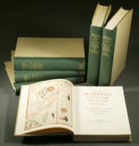
Mapping the Transmississippi West, 1540–1861,
by Wheat, Carl Irving (1892-1966)
- Used
- near fine
- Hardcover
- first
- Condition
- Used - Near Fine
- Edition
- First
- Binding
- Hardcover
- Quantity Available
- 1
- Seller
-
Fort Worth, Texas, United States
- Item Price
-
£2,217.88
Show Details
Description:
From the Spanish discovery to the opening of the Civil War5 volumes in 6. Volume One: The Spanish Entrada to the Louisiana Purchase 1540-1804 xiv+264 pages with color frontispiece map and 275 maps (many folding) and index; Volume Two: From Lewis and Clark to Fremont 1804-1845 xiii+281 pages with colored frontispiece map, 143 additional maps (some folding) and index. Volume Three: From the Mexican War to the Boundary Surveys 1846-1854 xiii+349 pages with colored frontispiece map, 322 additional maps and index; Volume Four: From the Pacific Railroad Surveys to the Onset of the Civil War 1855-1860 xiii+260 pages with color frontispiece map, an additional 127 maps (some folding) and index; Volume Five From the Civil War to the Geological Survey, Part One: xviii+222 pages with color frontispiece map and an additional 152 maps; Volume Five From the Civil War to the Geological Survey, Part Two: [223]-487 pages with 124 maps and index. Folio (14 1/2" x 10 1/2") bound in quarter green leather with gilt…
Read More Item Price
£2,217.88
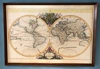
Mappe-Monde Geo-Hydrographique, ou Description Generale du Globe Terrestre et Aquatique en Deux Plans-Hemispheres; ou Sont Exactement Remarquees en General Toutes Les Parties De La Terre et de L'Eau, Suivant les Relations Les Plus Nouvelles. Par le S. Sanson, Geographe Ordinaire du Roy. 1684.
by Jaillot (Alexis-Hubert)
- Used
- Condition
- Used
- Binding
- Unknown
- Quantity Available
- 1
- Seller
-
Sidney, British Columbia, Canada
- Item Price
-
£2,822.75
Show Details
Description:
Paris, 1684. . Large double-hemisphere map, 36 x 25 inches (framed: 38 x 26.5 inches). Attractively coloured, decorative cartouche and embellishments. Modest wear at fold, some light marginal stains, an attractive copy. This map has been mounted on cardboard via an unknown process, but there is no evidence of damage. This looks to be Shirley's state 4 of the first plate, with Cordier's name beneath the left hemisphere (Cordier Sculp.) and a date of 1684. The first plate exists in four states, dated 1674, 1679, 1681, and 1684 (this one). An enlarged version of a previous map by Nicolas Sanson, beautiful and striking. Wheat 65, citing the 1684 edition.
Item Price
£2,822.75

More Photos
The Sky and the Forest
by Forester, C.S
- Used
- very good
- Hardcover
- first
- Condition
- Used - Very Good
- Jacket Condition
- Very Good
- Edition
- First Edition
- Binding
- Hardcover
- Quantity Available
- 1
- Seller
-
Salem, Oregon, United States
- Item Price
-
£28.14£14.07Save £17.44!
Show Details
Description:
C.S. Forester: The Sky and the Forest. Little, Brown and Company, Boston. Stated First Edition First Printing Thus August, 1948. Cover price $2.75. Used. VG BOOK/VG UNCLIPPED DUST JACKET. A story of a central Africa. By C.S. Forester, author of the Admiral Hornblower series.
Item Price
£28.14£14.07
Save £17.44
!

More Photos
Plat Book: Pierce County, Wisconsin
by Rhame, A. E
- Used
- Fine
- Paperback
- Condition
- Used - Fine
- Binding
- Paperback
- Quantity Available
- 1
- Seller
-
Woodruff, Wisconsin, United States
- Item Price
-
£37.63
Show Details
Description:
1930. Soft Cover. Fine. Unpaginated. Tan colored book is in Fine condition, no sign of wear.
Item Price
£37.63
![Alaska and Klondike Region; [With inset of Klondike Region on the Upper Yukon detail] [From an...](https://d3525k1ryd2155.cloudfront.net/h/062/537/1339537062.0.m.jpg)
Alaska and Klondike Region; [With inset of Klondike Region on the Upper Yukon detail] [From an atlas, "Gazetteer of Alaska and Yukon Region " pp. 105 and 106]
by Miller, J. Martin
- Used
- very good
- Condition
- Used - Very Good
- Edition
- Unknown
- Quantity Available
- 1
- Seller
-
Sebastopol, California, United States
- Item Price
-
£31.45
Show Details
Description:
Chicago: J. Martin Miller, 1899. Unknown. Map. Very Good. [Map copyright 1899, printing date of Atlas later] [19.875x15.125in]; Colored map of Alaska with steamer routes from Portland and Seattle, insets of the Klondike Region on the Upper Yukon and Western portion of Aleutian Islands; On verso index of places and names with two large black and white images; Age toning to all edges, water stain marks on bottom, slight printing offset of colors, small chips and closed tears to lower edge;.
Item Price
£31.45

Last Tales
by Dinesen, Isak
- Used
- very good
- Hardcover
- first
- Condition
- Used - Very Good
- Jacket Condition
- Good+
- Edition
- First Edition
- Binding
- Hardcover
- Quantity Available
- 1
- Seller
-
Salem, Oregon, United States
- Item Price
-
£96.78£48.39Save £60.00!
Show Details
Description:
Dinesen, Isak: Last Tales, A Collection of Twelve New Tales of Compelling Beauty 1957, Random House. First Edition. Stated First Printing Thus. Used. Very Good/Good+ original red dust jacket, price-clipped. Jacket states 11/57 on front flap. 5 3/4 X
Item Price
£96.78£48.39
Save £60.00
!

Zemepis Sveta - Monsunova Asie
by De La Blache, P. Vidal; Gallois, L
- Used
- Hardcover
- Condition
- Used - Very Good Condition
- Jacket Condition
- No Dust Jacket
- Binding
- Hardcover
- Quantity Available
- 1
- Seller
-
Oak Point, Texas, United States
- Item Price
-
£48.39
Show Details
Description:
Aventinum, Prague, Czechoslovakia, 1931. Hardcover. Very Good Condition/No Dust Jacket. Text entirely in Czech. Geography book on Asia with numerous photographs and maps. 1930 edition also available. Size: 4mo - over 9 3/4" - 12" tall. 400 pp. Pages are yellowed, but are tight and clean. Moderate shelfwear along the spine. Corners are lightly bumped. Quantity Available: 1. Shipped Weight: 3-5 pounds. Category: Travel & Places; Non-English Language::Czech; Pictures of this item not already displayed here available upon request. Inventory No: 001228. . Additional shipping charges may apply.
Item Price
£48.39

Zemepis Sveta - Monsunova Asie
by De La Blache, P. Vidal; Gallois, L
- Used
- Hardcover
- Condition
- Used - Very Good Condition
- Jacket Condition
- No Dust Jacket
- Binding
- Hardcover
- Quantity Available
- 1
- Seller
-
Oak Point, Texas, United States
- Item Price
-
£48.39
Show Details
Description:
Aventinum, Prague, Czechoslovakia, 1930. Hardcover. Very Good Condition/No Dust Jacket. Text entirely in Czech. Geography book on Asia with numerous photographs and maps. 1931 edition also available. Size: 4mo - over 9 3/4" - 12" tall. 400 pp. Pages are yellowed, but are tight and clean. Moderate shelfwear along the spine. Corners are lightly bumped. Quantity Available: 1. Shipped Weight: 3-5 pounds. Category: Travel & Places; Non-English Language::Czech; Pictures of this item not already displayed here available upon request. Inventory No: 001227. . Additional shipping charges may apply.
Item Price
£48.39

The Adventure of Wrangel Island
by Vilhjalmur Stefansson
- Used
- good
- Hardcover
- first
- Condition
- Used - Good
- Jacket Condition
- No DJ Included
- Edition
- First Edition
- Binding
- Hardcover
- Quantity Available
- 1
- Seller
-
Salem, Oregon, United States
- Item Price
-
£100.72£50.37Save £62.44!
Show Details
Description:
The Adventure of Wrangel Island, Alaska (1925 Macmillan 1st Edition) HISTORY OF ALASKA. EXLIB. Good Condition/ No DJ included. Fold-out map affixed to binding at the back of the book has never been opened. The story of the (unsuccessful) attempted colonization of Wrangel Island Alaska. 413 pages plus appendix, Index. Titling is still bright. A clean, solid copy. Scarce.
Item Price
£100.72£50.37
Save £62.44
!

Seven Pillars Of Wisdom, A Triumph
by Lawrence, T.E
- Used
- good
- Hardcover
- first
- Condition
- Used - Good
- Jacket Condition
- No DJ Included
- Edition
- First American Edition
- Binding
- Hardcover
- Quantity Available
- 1
- Seller
-
Salem, Oregon, United States
- Item Price
-
£100.77£50.39Save £62.47!
Show Details
Description:
T.E. Lawrence. SEVEN PILLARS OF WISDOM, A TRIUMPH. AUTOBIOGRAPHY. Privately Printed, 1926. First Published for general circulation 1935. First American Edition. States MCMXXXVI on the title page. Doubleday, Doran & Company, Inc. Garden City, NY. GOOD CONDITION/ NO DUST JACKET IS INCLUDED. 672 pages, indexed. Beige buckram boards. Spine has darkened a bit. 6 7/8 X 9 ½.
Item Price
£100.77£50.39
Save £62.47
!

North America from the Best Authorities, Russell, ca.1800
by Russell
- Used
- Condition
- Used
- Quantity Available
- 1
- Seller
-
Plymouth, Devon, United Kingdom
- Item Price
-
£20.00
Show Details
Description:
Russell, J. : A General Map of North America from the Best Authorities. Nd but ca.1800. From "A New Geographical, Historical and Commercial Grammar and Present State of Several Kingdoms of the World." Copper engraving. Size approx 200 x 230mm. Two neat folds. Some age colouring to edges, otherwise very clean and bright.
Item Price
£20.00

Asia from the Best Authorities, Russell, ca.1800
by Russell
- Used
- Condition
- Used
- Quantity Available
- 1
- Seller
-
Plymouth, Devon, United Kingdom
- Item Price
-
£20.00
Show Details
Description:
Russell, J. : Asia from the Best Authorities. Nd but ca.1800. From "A New Geographical, Historical and Commercial Grammar and Present State of Several Kingdoms of the World". Copper engraving. Size approx 200 x 230mm. Two neat folds. Some age colouring to edges, otherwise clean and bright. Includes Arabia, India, Borneo, Japan, China and eastern Russia.
Item Price
£20.00
