
Click for full-size.
Mapping the Transmississippi West, 1540–1861,
by Wheat, Carl Irving (1892-1966)
- Used
- near fine
- Hardcover
- first
- Condition
- Near Fine
- Seller
-
Fort Worth, Texas, United States
Payment Methods Accepted
About This Item
From the Spanish discovery to the opening of the Civil War
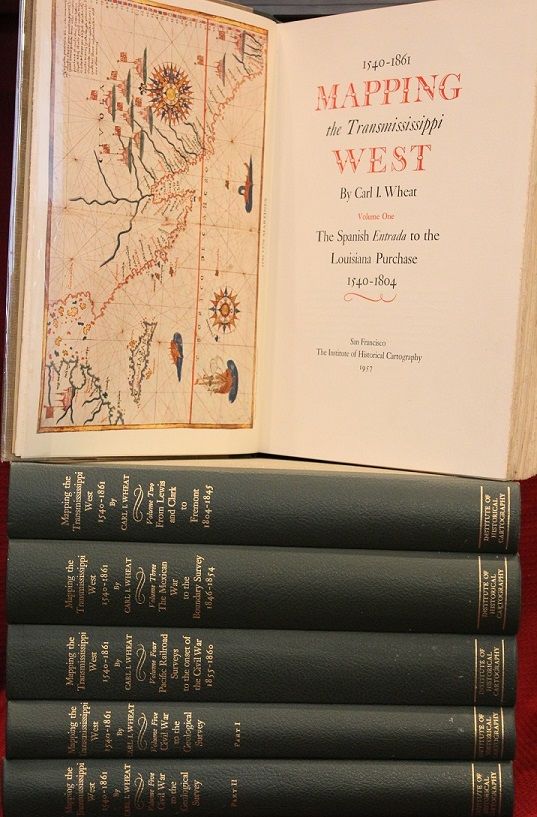
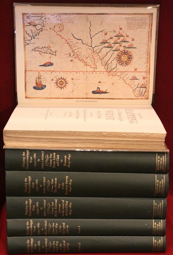
5 volumes in 6. Volume One: The Spanish Entrada to the Louisiana Purchase 1540-1804 xiv+264 pages with color frontispiece map and 275 maps (many folding) and index; Volume Two: From Lewis and Clark to Fremont 1804-1845 xiii+281 pages with colored frontispiece map, 143 additional maps (some folding) and index. Volume Three: From the Mexican War to the Boundary Surveys 1846-1854 xiii+349 pages with colored frontispiece map, 322 additional maps and index; Volume Four: From the Pacific Railroad Surveys to the Onset of the Civil War 1855-1860 xiii+260 pages with color frontispiece map, an additional 127 maps (some folding) and index; Volume Five From the Civil War to the Geological Survey, Part One: xviii+222 pages with color frontispiece map and an additional 152 maps; Volume Five From the Civil War to the Geological Survey, Part Two: [223]-487 pages with 124 maps and index. Folio (14 1/2" x 10 1/2") bound in quarter green leather with gilt lettering to spines. volume I printed by the Grabhorn Press; volumes II-V printed by Taylor & Taylor and James Printing based on the designs of Edwin and Robert Grabhorn. First edition limited to 1000 copies.
Carl Wheat's Mapping of the Trans-Mississippi West is a comprehensive and readable cartographic history of the American West. The first three volumes of the work are by necessity bulky and out sized to accommodate the many maps contained with their covers. These beautifully printed books present a truly graphic picture of the exploration and peopling of the vast unknown land west of the Mississippi. The author does not merely present a catalog of significant maps of each era but tells the exciting story of many facets of history that resulted in their making-of the hard journeys, the hazardous exploits, the motivation, the mysticism, the misunderstandings and the strange blend of fact, imagination, false geographic concept and political necessity which were consummated in the engraver's work. These volumes will provide exciting text for the casual reader and have become eminent source book for the student and scholar.
Condition:
A near fine set. Due to the size and/or weight of this lot extra shipping and/or handling charges may apply.
Reviews
(Log in or Create an Account first!)
Details
- Bookseller
- The Book Collector ABAA, ILAB, TBA
 (US)
(US)
- Bookseller's Inventory #
- E0551
- Title
- Mapping the Transmississippi West, 1540–1861,
- Author
- Wheat, Carl Irving (1892-1966)
- Book Condition
- Used - Near Fine
- Quantity Available
- 1
- Edition
- First
- Binding
- Hardcover
- Publisher
- Institute of Historical Cartography
- Place of Publication
- San Francisco
- Date Published
- 1957-1963
- Pages
- 5 volumes in 6
- Size
- Folio
- Weight
- 0.00 lbs
- Keywords
- Maps bibliogrpahy
- Bookseller catalogs
- Exploration;
- Note
- May be a multi-volume set and require additional postage.
Terms of Sale
The Book Collector ABAA, ILAB, TBA
All items are guaranteed as described. If an item is
not as described, it is returnable within seven days
of receipt, unless other arrangements are made.
Full refunds given only when items are received in
the same condition in which they were sent.
We require new customers to send payment with
their order. Customers known to us will be invoiced
with payment due in thirty days, unless prior
arrangements are made. Institutions will be billed
to meet their requirements. All items subject to prior
sale.
We accept Visa, Mastercard, and American Express
Please be advised that we can only ship to your billing address.
We accept checks, but may require that the check clears before we ship an order.
Prices of books do not include shipping.
We use UPS domestically and internationally. Other shipping arrangements can be made. Shipping is always charged at cost.
Texas residents must add 8.25% sales tax.
About the Seller
The Book Collector ABAA, ILAB, TBA
Biblio member since 2005
Fort Worth, Texas
About The Book Collector ABAA, ILAB, TBA
The Book Collector specializes in the finest collections of Chess, Anthropology, Americana and American Literature. Visit our website at www.bookcollectorshop.com
Glossary
Some terminology that may be used in this description includes:
- First Edition
- In book collecting, the first edition is the earliest published form of a book. A book may have more than one first edition in...
- Fine
- A book in fine condition exhibits no flaws. A fine condition book closely approaches As New condition, but may lack the...
- Folio
- A folio usually indicates a large book size of 15" in height or larger when used in the context of a book description. Further,...
- Gilt
- The decorative application of gold or gold coloring to a portion of a book on the spine, edges of the text block, or an inlay in...
Frequently asked questions
This Book’s Categories

Collecting food and drink books
Nothing quite whets the appetite for rare and collectible books like old and vintage cookbooks. Be sure to check out our cook books and food section of our rare book room.

A Brief History of the Dust Jacket
When did dust jackets first appear, and what exactly are they for? Learn about this often-important detail as it applies to book collecting. More...
![Stockton Looking East. San Joaquin County, Cal. Original Bird's Eye View. [LITHOGRAPH]](https://d3525k1ryd2155.cloudfront.net/h/929/544/257544929.0.m.jpg)


