Description:
Cary, John: A Map of Cheshire. John Stockdale 26th March 1805. Engraved by J Cary 43x 53cm. Uncoloured. Two vertical folds. Some age toning on map, otherwise good strong print with great detail and accuracy. Excellent condition.
Imperii Romani - Antique map from 1826 by Giraldon-Bovinet - 1826: Two parts antique map of Roman Empire
by Giraldon-Bovinet

Imperii Romani - Antique map from 1826: Two parts antique map of Roman Empire
by Giraldon-Bovinet
- Used
- very good
Original antique map of Roman Empire in two parts. From L'atlas universel de la géographie et de l'histoire anciennes et modernes.
Engraved by 19th-century French engraver, Giraldon-Bovinet.
Condition: The map is in very good condition with some minor stains along the edges, some signs of restoration are present also.
Dimensions of paper: 60 x 43 cm
Dimensions of each engraving: 45 x 30 cm.
Free shipping. If you have any additional questions or inquiries, please don't hesitate to contact us!
-
Seller
Sigedon LTD
 (SC)
(SC)
- Book Condition Used - Very Good
- Quantity Available 1
- Publisher Mennard et Desenne
- Place of Publication Paris
- Date Published 1826
- Size Large
- Keywords engraving, print, paris, rome, map
- Size Large

Original Antique Map of Cheshire
by John Cary
- Used
- good
- Condition
- Used - Good
- Quantity Available
- 1
- Seller
-
Plymouth, Devon, United Kingdom
- Item Price
-
£40.00
Show Details
Item Price
£40.00

Zemepis Sveta - Monsunova Asie
by De La Blache, P. Vidal; Gallois, L
- Used
- Hardcover
- Condition
- Used - Very Good Condition
- Jacket Condition
- No Dust Jacket
- Binding
- Hardcover
- Quantity Available
- 1
- Seller
-
Oak Point, Texas, United States
- Item Price
-
£48.56
Show Details
Description:
Aventinum, Prague, Czechoslovakia, 1931. Hardcover. Very Good Condition/No Dust Jacket. Text entirely in Czech. Geography book on Asia with numerous photographs and maps. 1930 edition also available. Size: 4mo - over 9 3/4" - 12" tall. 400 pp. Pages are yellowed, but are tight and clean. Moderate shelfwear along the spine. Corners are lightly bumped. Quantity Available: 1. Shipped Weight: 3-5 pounds. Category: Travel & Places; Non-English Language::Czech; Pictures of this item not already displayed here available upon request. Inventory No: 001228. . Additional shipping charges may apply.
Item Price
£48.56
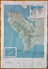
Freetown, Sierra Leone, Special Sheet map 1:50,000 (DOS, 419; 1968)
by United Kingdom. Directorate of Overseas Surveys
- Used
- very good
- first
- Condition
- Used - Very Good
- Edition
- First Edition
- Quantity Available
- 1
- Seller
-
Arlington, Virginia, United States
- Item Price
-
£115.33£69.20Save £57.00!
Show Details
Description:
RARE! Tolworth, Surrey, England: Great Britain. Directorate of Overseas Surveys, 419. First Edition. 1968. D.O.S. 419. Printed on one side. Color. 45.5" x 31" (116 x 79 cm) heavy paper sheet, folded after purchase. Condition: Very Good: Map is unmarked. Small tears, chips, and tape scars to the margins. Creases from post-purchase folding. Suitable for mounting/framing. Contents: Freetown Peninsula (Western Area) 1:50,000; Inset: Freetown (city center) 1:10,000; Inset: Banana Islands 1:50,000.
Item Price
£115.33£69.20
Save £57.00
!

The Cossacks: A Tale of the Caucasus in the Year 1852. UKRAINIA
by Tolstoi, Count Lyof N.
- Used
- Hardcover
- first
- Condition
- Used - Good-
- Jacket Condition
- No DJ Included
- Edition
- First English Edition
- Binding
- Hardcover
- Quantity Available
- 1
- Seller
-
Salem, Oregon, United States
- Item Price
-
£117.35£70.41Save £58.00!
Show Details
Description:
UKRAINIA Tolstoi, Count Lyof N.: The Cossacks: A Tale of the Caucasus in the Year 1852. First English Edition, 1888 Walter Scott, 24 Warwick Lane, Paternoster Row, London. Translated from the Russian by Nathan Haskell Dole. Summary: A novel of the Caucasian War 1817-1864. Used. Good- Condition/ No DJ. Blue Boards gold titling and ornamentation. Imperial Russian crest stamped in gilt at center front. A solid copy. Light foxing to endpapers. Toning. Fabric at top of spine missing. RARE/SCARCE.
Item Price
£117.35£70.41
Save £58.00
!

More Photos
Britannicae Insulae: Antique map of Great Britain
by Robert de Vaugondy
- Used
- very good
- Condition
- Used - Very Good
- Quantity Available
- 1
- Seller
-
Providence, Seychelles
- Item Price
-
£141.63
Show Details
Description:
FULL TITLE: Britannicae, Insulae in quibus Albion Seu Britannia Major, et Ivernia seu Britannia Minor juxta Ptolemaei mentem divisae tùm in suas majores partes, tùm in populos exhibentur, à Nicolao sanson Christ, Regis Geographo, Revisae, et ad observationes astronomicas redactae, accurante Robert de Vaugondy filio, gum Privilegio Regis'DATE PRINTED: 1750 IMAGE SIZE: Approx 50.0 x 55.0cm, 19.5 x 21.5 inches (Large); Please note that this is a folding map.TYPE: Large antique 18th-century atlas map, printed on thick, good quality paper. partially hand-colored.CONDITION: Good; suitable for framing. Please check the scan for any blemishes prior to making your purchase. Virtually all antiquarian maps and prints are subject to some normal aging due to use and time which is not obtrusive unless otherwise stated. We offer a no-questions-asked return policy.AUTHENTICITY: This is an authentic historic map, published at the date stated above. It is not a modern copy.VERSO: Short map title printed on the…
Read More Item Price
£141.63
Zemepis Sveta - Monsunova Asie
by De La Blache, P. Vidal; Gallois, L
- Used
- Hardcover
- Condition
- Used - Very Good Condition
- Jacket Condition
- No Dust Jacket
- Binding
- Hardcover
- Quantity Available
- 1
- Seller
-
Oak Point, Texas, United States
- Item Price
-
£48.56
Show Details
Description:
Aventinum, Prague, Czechoslovakia, 1931. Hardcover. Very Good Condition/No Dust Jacket. Text entirely in Czech. Geography book on Asia with numerous photographs and maps. 1930 edition also available. Size: 4mo - over 9 3/4" - 12" tall. 400 pp. Pages are yellowed, but are tight and clean. Moderate shelfwear along the spine. Corners are lightly bumped. Quantity Available: 1. Shipped Weight: 3-5 pounds. Category: Travel & Places; Non-English Language::Czech; Pictures of this item not already displayed here available upon request. Inventory No: 001228. . Additional shipping charges may apply.
Item Price
£48.56
The Cossacks: A Tale of the Caucasus in the Year 1852. UKRAINIA
by Tolstoi, Count Lyof N.
- Used
- Hardcover
- first
- Condition
- Used - Good-
- Jacket Condition
- No DJ Included
- Edition
- First English Edition
- Binding
- Hardcover
- Quantity Available
- 1
- Seller
-
Salem, Oregon, United States
- Item Price
-
£117.35£70.41Save £58.00!
Show Details
Description:
UKRAINIA Tolstoi, Count Lyof N.: The Cossacks: A Tale of the Caucasus in the Year 1852. First English Edition, 1888 Walter Scott, 24 Warwick Lane, Paternoster Row, London. Translated from the Russian by Nathan Haskell Dole. Summary: A novel of the Caucasian War 1817-1864. Used. Good- Condition/ No DJ. Blue Boards gold titling and ornamentation. Imperial Russian crest stamped in gilt at center front. A solid copy. Light foxing to endpapers. Toning. Fabric at top of spine missing. RARE/SCARCE.
Item Price
£117.35£70.41
Save £58.00
!

Last Tales
by Dinesen, Isak
- Used
- very good
- Hardcover
- first
- Condition
- Used - Very Good
- Jacket Condition
- Good+
- Edition
- First Edition
- Binding
- Hardcover
- Quantity Available
- 1
- Seller
-
Salem, Oregon, United States
- Item Price
-
£97.12£58.27Save £48.00!
Show Details
Description:
Dinesen, Isak: Last Tales, A Collection of Twelve New Tales of Compelling Beauty 1957, Random House. First Edition. Stated First Printing Thus. Used. Very Good/Good+ original red dust jacket, price-clipped. Jacket states 11/57 on front flap. 5 3/4 X
Item Price
£97.12£58.27
Save £48.00
!
More Photos
Britannicae Insulae: Antique map of Great Britain
by Robert de Vaugondy
- Used
- very good
- Condition
- Used - Very Good
- Quantity Available
- 1
- Seller
-
Providence, Seychelles
- Item Price
-
£141.63
Show Details
Description:
FULL TITLE: Britannicae, Insulae in quibus Albion Seu Britannia Major, et Ivernia seu Britannia Minor juxta Ptolemaei mentem divisae tùm in suas majores partes, tùm in populos exhibentur, à Nicolao sanson Christ, Regis Geographo, Revisae, et ad observationes astronomicas redactae, accurante Robert de Vaugondy filio, gum Privilegio Regis'DATE PRINTED: 1750 IMAGE SIZE: Approx 50.0 x 55.0cm, 19.5 x 21.5 inches (Large); Please note that this is a folding map.TYPE: Large antique 18th-century atlas map, printed on thick, good quality paper. partially hand-colored.CONDITION: Good; suitable for framing. Please check the scan for any blemishes prior to making your purchase. Virtually all antiquarian maps and prints are subject to some normal aging due to use and time which is not obtrusive unless otherwise stated. We offer a no-questions-asked return policy.AUTHENTICITY: This is an authentic historic map, published at the date stated above. It is not a modern copy.VERSO: Short map title printed on the…
Read More Item Price
£141.63

More Photos
Mediterranean, the Dardanelles (ancient Hellespont): Nautical map of the Dardanelles
by Hydrographic Office of Great Britain
- Used
- Condition
- Used - Good-
- Edition
- Large corrections Sept. 1880. Small corrections to 1914.
- Quantity Available
- 1
- Seller
-
Providence, Seychelles
- Item Price
-
£141.63
Show Details
Description:
Hydrographic chart of the Dardanelles Strait region, Turkey. Relief is shown by spot heights and hachures. Depths are shown by bathymetric isolines and soundings.The chart is damaged along the edges with some tears in the middle. Wrinkles and some pencil inscriptions, signs of aging and wear. Please see the photos. Free Shipping included. The map will be shipped in a strong cardboard tube.If you have any questions or inquiries, please don't hesitate to contact us!
Item Price
£141.63

Aegyptus.
by GIRALDON-BOVINET
- Used
- Condition
- Used
- Quantity Available
- 1
- Seller
-
London, United Kingdom
- Item Price
-
£110.00
Show Details
Description:
Paris: J. B. Tardieu,, [c.1811]. A map of Egypt with a very decorative cartouche showing some figures in camels, the River Nile and the three most famous Pyramids of all Egypt. Sheet size: 410 x 282 mm Plate size: 320 x 245 mm Copper engraving. Hand coloured. Very good condition.
Item Price
£110.00

Map of Ireland
by Bovinet,Giraldon
- Used
- near fine
- first
- Condition
- Used - Near Fine
- Jacket Condition
- Not called for>
- Edition
- 1st Edition 1st Printing
- Quantity Available
- 1
- Seller
-
Dublin, Dublin, Ireland
- Item Price
-
£195.21
Show Details
Description:
paris: J.B.Tardieu, 1812. 1st Edition 1st Printing. No Binding. Near Fine/Not called for>. Original hand coloring (In outline) as published. Recently framed with double mount. 21x17 inches (31x23) Cartouche representing the Giant' s Causeway. Map is complete and hardly any wear.Contact seller regarding shipping.
Item Price
£195.21

More Photos
The Sky and the Forest
by Forester, C.S
- Used
- very good
- Hardcover
- first
- Condition
- Used - Very Good
- Jacket Condition
- Very Good
- Edition
- First Edition
- Binding
- Hardcover
- Quantity Available
- 1
- Seller
-
Salem, Oregon, United States
- Item Price
-
£28.24£16.94Save £13.96!
Show Details
Description:
C.S. Forester: The Sky and the Forest. Little, Brown and Company, Boston. Stated First Edition First Printing Thus August, 1948. Cover price $2.75. Used. VG BOOK/VG UNCLIPPED DUST JACKET. A story of a central Africa. By C.S. Forester, author of the Admiral Hornblower series.
Item Price
£28.24£16.94
Save £13.96
!
![Alaska and Klondike Region; [With inset of Klondike Region on the Upper Yukon detail] [From an...](https://d3525k1ryd2155.cloudfront.net/h/062/537/1339537062.0.m.jpg)
Alaska and Klondike Region; [With inset of Klondike Region on the Upper Yukon detail] [From an atlas, "Gazetteer of Alaska and Yukon Region " pp. 105 and 106]
by Miller, J. Martin
- Used
- very good
- Condition
- Used - Very Good
- Edition
- Unknown
- Quantity Available
- 1
- Seller
-
Sebastopol, California, United States
- Item Price
-
£31.56
Show Details
Description:
Chicago: J. Martin Miller, 1899. Unknown. Map. Very Good. [Map copyright 1899, printing date of Atlas later] [19.875x15.125in]; Colored map of Alaska with steamer routes from Portland and Seattle, insets of the Klondike Region on the Upper Yukon and Western portion of Aleutian Islands; On verso index of places and names with two large black and white images; Age toning to all edges, water stain marks on bottom, slight printing offset of colors, small chips and closed tears to lower edge;.
Item Price
£31.56

Zemepis Sveta - Monsunova Asie
by De La Blache, P. Vidal; Gallois, L
- Used
- Hardcover
- Condition
- Used - Very Good Condition
- Jacket Condition
- No Dust Jacket
- Binding
- Hardcover
- Quantity Available
- 1
- Seller
-
Oak Point, Texas, United States
- Item Price
-
£48.56
Show Details
Description:
Aventinum, Prague, Czechoslovakia, 1930. Hardcover. Very Good Condition/No Dust Jacket. Text entirely in Czech. Geography book on Asia with numerous photographs and maps. 1931 edition also available. Size: 4mo - over 9 3/4" - 12" tall. 400 pp. Pages are yellowed, but are tight and clean. Moderate shelfwear along the spine. Corners are lightly bumped. Quantity Available: 1. Shipped Weight: 3-5 pounds. Category: Travel & Places; Non-English Language::Czech; Pictures of this item not already displayed here available upon request. Inventory No: 001227. . Additional shipping charges may apply.
Item Price
£48.56
Zemepis Sveta - Monsunova Asie
by De La Blache, P. Vidal; Gallois, L
- Used
- Hardcover
- Condition
- Used - Very Good Condition
- Jacket Condition
- No Dust Jacket
- Binding
- Hardcover
- Quantity Available
- 1
- Seller
-
Oak Point, Texas, United States
- Item Price
-
£48.56
Show Details
Description:
Aventinum, Prague, Czechoslovakia, 1931. Hardcover. Very Good Condition/No Dust Jacket. Text entirely in Czech. Geography book on Asia with numerous photographs and maps. 1930 edition also available. Size: 4mo - over 9 3/4" - 12" tall. 400 pp. Pages are yellowed, but are tight and clean. Moderate shelfwear along the spine. Corners are lightly bumped. Quantity Available: 1. Shipped Weight: 3-5 pounds. Category: Travel & Places; Non-English Language::Czech; Pictures of this item not already displayed here available upon request. Inventory No: 001228. . Additional shipping charges may apply.
Item Price
£48.56

Asia from the Best Authorities, Russell, ca.1800
by Russell
- Used
- Condition
- Used
- Quantity Available
- 1
- Seller
-
Plymouth, Devon, United Kingdom
- Item Price
-
£20.00
Show Details
Description:
Russell, J. : Asia from the Best Authorities. Nd but ca.1800. From "A New Geographical, Historical and Commercial Grammar and Present State of Several Kingdoms of the World". Copper engraving. Size approx 200 x 230mm. Two neat folds. Some age colouring to edges, otherwise clean and bright. Includes Arabia, India, Borneo, Japan, China and eastern Russia.
Item Price
£20.00

North America from the Best Authorities, Russell, ca.1800
by Russell
- Used
- Condition
- Used
- Quantity Available
- 1
- Seller
-
Plymouth, Devon, United Kingdom
- Item Price
-
£20.00
Show Details
Description:
Russell, J. : A General Map of North America from the Best Authorities. Nd but ca.1800. From "A New Geographical, Historical and Commercial Grammar and Present State of Several Kingdoms of the World." Copper engraving. Size approx 200 x 230mm. Two neat folds. Some age colouring to edges, otherwise very clean and bright.
Item Price
£20.00
![MAP OF UTAH [Territory]](https://d3525k1ryd2155.cloudfront.net/h/836/461/1485461836.0.m.jpg)
More Photos
MAP OF UTAH [Territory]
- Used
- Condition
- Used - Very Good-
- Edition
- Original
- Quantity Available
- 1
- Seller
-
Williamsburg, Virginia, United States
- Item Price
-
£52.60
Show Details
Description:
New York, Richmond, Chicago, & Toledo: H. H. Hardesty, 1885. Original color lithographed map printed by Rand, McNally & Company, Engravers and published in HARDESTY'S HISTORICAL AND GEOGRAPHICAL ENCYCLOPEDIA: SPECIAL VIRGINIA EDITION. 19 3/8 inches by 13 1/4 inches on a 21" X 14 1/2" sheet. The map depicts the Territory of Utah in its final form--large areas had been removed and ceded to Nevada, Colorado, Wyoming, and Nebraska since Utah became a U. S. Territory in 1850. The issue of polygamy prevented statehood until it was finally granted in 1896. This map features railroads and topography and uses color to set off counties from each other. Unlike most atlas maps of the period, this map identifies most small towns. The map is guaranteed to be moe than 135 years old. The map is in about very good condition: generally clean and bright, with slight toning of paper and one faint water stain near the center-left edge of the map.. Original. Single Sheet. Very Good-. Elephant…
Read More Item Price
£52.60

Philips Special Map of the Nile, The Advance on Khartum and the Environs of Omdurman. Cc1900
by George Philips and Son,
- Used
- Condition
- Used
- Quantity Available
- 1
- Seller
-
Plymouth, Devon, United Kingdom
- Item Price
-
£26.00
Show Details
Description:
Philips Special map of the Nile illustrating the Advance on Khartum [Khartoum] with an enlargement of the environs of Omdurman [Omdur]. George Philips and Son, London and Liverpool Ca 1900. 580mm x 900mm folded map. Front title wrapper has come loose, not affecting map area. Three maps are displayed within the sheet. Map1. Map of the Nile Valley 520mm x 300mm showing the approaches of Khartum. Scale 1inch to 100 Geographical miles. Coloured indicating Possessions and Protectorates of European Powers. Map 2. Special map of the Nile from Dongola to Khartum. Scale 16 miles to the inch. Coloured. In set in this map is Map3. Environs of Omdurman, Scale 5 statute miles to the inch. Some small breaks at some folds, not affecting imagery or use of map. Title label is damaged, the map is clean and bright, probably unused. A very interesting record.
Item Price
£26.00
Last Tales
by Dinesen, Isak
- Used
- very good
- Hardcover
- first
- Condition
- Used - Very Good
- Jacket Condition
- Good+
- Edition
- First Edition
- Binding
- Hardcover
- Quantity Available
- 1
- Seller
-
Salem, Oregon, United States
- Item Price
-
£97.12£58.27Save £48.00!
Show Details
Description:
Dinesen, Isak: Last Tales, A Collection of Twelve New Tales of Compelling Beauty 1957, Random House. First Edition. Stated First Printing Thus. Used. Very Good/Good+ original red dust jacket, price-clipped. Jacket states 11/57 on front flap. 5 3/4 X
Item Price
£97.12£58.27
Save £48.00
!

The Adventure of Wrangel Island
by Vilhjalmur Stefansson
- Used
- good
- Hardcover
- first
- Condition
- Used - Good
- Jacket Condition
- No DJ Included
- Edition
- First Edition
- Binding
- Hardcover
- Quantity Available
- 1
- Seller
-
Salem, Oregon, United States
- Item Price
-
£101.07£60.64Save £49.96!
Show Details
Description:
The Adventure of Wrangel Island, Alaska (1925 Macmillan 1st Edition) HISTORY OF ALASKA. EXLIB. Good Condition/ No DJ included. Fold-out map affixed to binding at the back of the book has never been opened. The story of the (unsuccessful) attempted colonization of Wrangel Island Alaska. 413 pages plus appendix, Index. Titling is still bright. A clean, solid copy. Scarce.
Item Price
£101.07£60.64
Save £49.96
!
