Rare and Antiquarian Books
Maps and Atlases
Results 16 - 30 of 308

More Photos
Asia Distinguished in its Principall Parts uiz Turky in Asia, Arabia, Persia, India, China, Tartaria, The Islands of Japan, of the Philippines, of the Moluckes, of the Sundaes, of Ceylan, and of the Maldivies, where are set down the Empires, Monarchies...
by Sanson, (Nicolas)/Berry, William
- Used
- Condition
- Used - Gut
- Seller
-
Velbert, Germany
- Item Price
-
£4,676.36£22.50 shipping to USA
Show Details
Item Price
£4,676.36
£22.50
shipping to USA

More Photos
Britannia: or a chorographical description of Great Britain and Ireland, together with the adjacent islands. Written in Latin by William Camden, Clarenceux, King at Arms: and translated into English, with additions and improvements. The second edition. Revised, digested, and published, with large additions, by Edmund Gibson, D. D. Rector of Lambeth; and now Bishop of Lincoln, and Dean of His Majesty's Chapel-Royal
by CAMDEN, William (1551-1623)
- Used
- Fine
- Condition
- Used - Fine
- Seller
-
Lancaster, Pennsylvania
- Item Price
-
£2,953.14£5.00 shipping to USA
Show Details
Item Price
£2,953.14
£5.00
shipping to USA

More Photos
A Modern, Authentic and Complete System of Universal Geography
by Rev. Thomas Bankes
- Used
- very good
- Hardcover
- Condition
- Used - Very Good
- Binding
- Hardcover
- Seller
-
Farningham, Kent
- Item Price
-
£3,450.00£25.15 shipping to USA
Show Details
Item Price
£3,450.00
£25.15
shipping to USA
![THE ANCIENT AND PRESENT STATE OF GLOCESTERSHIRE [Gloucestershire] .. Second Edition. Illustrated...](https://d3525k1ryd2155.cloudfront.net/h/942/004/816004942.0.m.jpg)
THE ANCIENT AND PRESENT STATE OF GLOCESTERSHIRE [Gloucestershire] .. Second Edition. Illustrated with seventy-three copper-plates, Containing a Map of the County, a Plan and Prospect of the City, a View of the Cathedral, Sixty One Seats, and Three Hundred and Twenty Coats of Arms, of the Nobility and Gentry residing in the County at the Time of the first Publication.
by Atkyns, Sir Robert (1647-1711)
- Used
- very good
- Hardcover
- Condition
- Used - Very Good
- Binding
- Hardcover
- Seller
-
Blockley, Gloucestershire
- Item Price
-
£3,920.00£25.75 shipping to USA
Show Details
Item Price
£3,920.00
£25.75
shipping to USA
More Photos
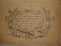
RARE OTTOMAN MILITARY MAP OF KARA DAG (MONT NEGRO)
by Ottoman General Staff Section
- Used
- very good
- Condition
- Used - Very Good
- Seller
-
Riyadh, Saudi Arabia
- Item Price
-
£4,046.50£15.50 shipping to USA
Show Details
Item Price
£4,046.50
£15.50
shipping to USA

More Photos
Avrupa-i Osmani Haritasi (Wall map of the Ottoman Europe), extra ordinary copy of an Ottoman lieutenant
- Used
- very good
- Condition
- Used - Very Good
- Seller
-
Riyadh, Saudi Arabia
- Item Price
-
£5,665.10£15.50 shipping to USA
Show Details
Item Price
£5,665.10
£15.50
shipping to USA
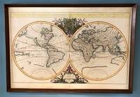
Mappe-Monde Geo-Hydrographique, ou Description Generale du Globe Terrestre et Aquatique en Deux Plans-Hemispheres; ou Sont Exactement Remarquees en General Toutes Les Parties De La Terre et de L'Eau, Suivant les Relations Les Plus Nouvelles. Par le S. Sanson, Geographe Ordinaire du Roy. 1684.
by Jaillot (Alexis-Hubert)
- Used
- Condition
- Used
- Seller
-
Sidney, British Columbia
- Item Price
-
£2,832.55£18.00 shipping to USA
Show Details
Item Price
£2,832.55
£18.00
shipping to USA

More Photos
The Reconquest of Peloponnese: MEMORIE ISTORIO GRAFICHE DE REGNI DELLA MOREA NEGROPONTE E LITTORALI FIN Á SALONICHI. ACERESCIUTE IN GUESTA SECONDA EDIZIONE
by CORONELLI, Vincenzo María
- Used
- Condition
- Used - Very Good+
- Edition
- Segunda
- Seller
-
Cuernavaca, Mexico
- Item Price
-
£3,560.92£90.00 shipping to USA
Show Details
Item Price
£3,560.92
£90.00
shipping to USA

More Photos
A General Atlas, containing Maps illustrating some important periods in Ancient History and distinct Maps of the several Empires, Kingdoms and States in the World,: From Original Drawings according to the latest Treaties by J. Wyld and Engraved by N. R. Hewitt
by WYLD, James
- Used
- very good
- Hardcover
- Condition
- Used - Very good
- Edition
- Second Edition
- Binding
- Hardcover
- Seller
-
London, Ontario
- Item Price
-
£4,855.80£8.25 shipping to USA
Show Details
Item Price
£4,855.80
£8.25
shipping to USA
More Photos
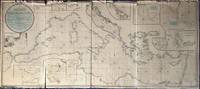
A New Chart of the Mediterranean Sea, Comprehending the Coasts from Cape St. Mary, (in Portugal) to Constantinople, and from Rabat, in Africa, to Alexandretto, or Iskenderoon, in Asia &c. Reduced from the new Spanish and French Charts made by Order of the respective Governments, From Several Documents of Lord Viscount Nelson, and other recent Authorities, By Joseph Dessiou, Master, &c.
by Dessiou (Joseph)
- Used
- Condition
- Used
- Seller
-
Sidney, British Columbia
- Item Price
-
£4,046.50£18.00 shipping to USA
Show Details
Item Price
£4,046.50
£18.00
shipping to USA
![Map of Peking. 京城內外全圖 .[Jing cheng nei wai quan tu].](https://d3525k1ryd2155.cloudfront.net/h/215/732/1340732215.0.m.jpg)
Map of Peking. 京城內外全圖 .[Jing cheng nei wai quan tu].
by [BOXER REBELLION MAP OF BEIJING].
- Used
- Condition
- Used
- Seller
-
Canberra, Australian Capital Territory
- Item Price
-
£4,096.65£30.00 shipping to USA
Show Details
Item Price
£4,096.65
£30.00
shipping to USA
![Theatro del mundo y de el tiempo compuesto por Ioan Paulo Gallucio Salo[n]ese; traducido de...](https://d3525k1ryd2155.cloudfront.net/h/806/735/1343735806.0.m.jpg)
More Photos
Theatro del mundo y de el tiempo compuesto por Ioan Paulo Gallucio Salo[n]ese; traducido de lengua latina en castellana y anadido por Miguel Perez: (Theatro del mundo y de el tiempo compuesto por Ioan Paulo Gallucio Salo[n]ese; traducido de lengua latina en castellana y añadido por Miguel Perez)
by Giovanni Paolo Gallucci
- Used
- fair
- Condition
- Used - Fair
- Seller
-
Fort Lauderdale, Florida
- Item Price
-
£3,439.52£9.00 shipping to USA
Show Details
Item Price
£3,439.52
£9.00
shipping to USA
More Photos
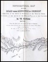
Topographical Map of the Road From Missouri To Oregon Commencing at the Mouth of the Kansas in the Missouri River and Ending at the Mouth of the Wallah Wallah in the Columbia
by Preuss. Charles; Fremont, John Charles
- Used
- very good
- Condition
- Used - Very good
- Seller
-
Chehalis, Washington
- Item Price
-
£3,641.85£5.50 shipping to USA
Show Details
Item Price
£3,641.85
£5.50
shipping to USA

More Photos
A New and Complete System of Universal Geography; Describing Asia, Africa, Europe and America; in Four Volumes (v1-1798, v2-1800, v3-1799, v4-1799): "Paynes Universal Geography", FIRST EDITION
by Payne, John
- Used
- Hardcover
- first
- Condition
- Used - Very Good+
- Edition
- First
- Binding
- Hardcover
- Seller
-
Lincoln, Nebraska
- Item Price
-
£4,036.59£5.00 shipping to USA
Show Details
Item Price
£4,036.59
£5.00
shipping to USA

More Photos
History of the United States, or Republic of America, 1828 First Edition: AND A Series of Maps to Willard's History of the United States, First Edition
by Willard, Emma
- Used
- very good
- Hardcover
- first
- Condition
- Used - Very Good
- Edition
- First
- Binding
- Hardcover
- Seller
-
Lincoln, Nebraska
- Item Price
-
£4,044.68£5.00 shipping to USA
Show Details
Item Price
£4,044.68
£5.00
shipping to USA

