Description:
Sir Joseph Causton & Sons Ltd FIDOR Fibre Building Board Development Organisation Limited. Large Poster measure 76 cms (30 inches) X 56 cms (22 inches) Full colour. In very good condition. Ideal for Work Shop/Shed.
Search Results: Titles starting with O from The Antique Map & Bookshop
You searched for:
- Bookseller inventory: The Antique Map & Bookshop (titles starting with O)
- Bookseller: The Antique Map & Bookshop
Results 1 - 20 of 538

ORIGINAL POSTER. Fibre Building Boards. 2 - Manufacture
- Used
- Condition
- Used
- Quantity Available
- 1
- Seller
-
Dorchester, Dorset, United Kingdom
- Item Price
-
£15.00£14.95 shipping to USA
Show Details
Item Price
£15.00
£14.95
shipping to USA

More Photos
ORIGINAL ENGRAVED ANTIQUE MAP OF SURREY With extra distances in miles page.
by MORDEN, ROBERT:
- Used
- Condition
- Used
- Quantity Available
- 1
- Seller
-
Dorchester, Dorset, United Kingdom
- Item Price
-
£53.00£14.95 shipping to USA
Show Details
Description:
From Britannia & Hibernio Ca 1714. Uncoloured. “See East Grimstead bottom right corner,confirm later edition after 1714” In good condition. With foxing marks on margins & center fold. Engraved surface 21 cm x 17.5cm. The title of the county is contained in an ornamental cartouche. Robert Morden's series of smaller maps thought to have been engraved in about 1693 for Edmund Gibson's translation of Camden's Britannia published in 1695 but rejected for being too small. Morden published them a few years later in 1701 in his New Description and state of England, then again in Britannia & Hibernio Ca 1714-1730
Item Price
£53.00
£14.95
shipping to USA

More Photos
ORIGINAL ENGRAVED MAP OF WESTMORELAND. From “The English Counties Delineated”. Or, A Topographical Description of England.
by MOULE, THOMAS:
- Used
- Condition
- Used
- Quantity Available
- 1
- Seller
-
Dorchester, Dorset, United Kingdom
- Item Price
-
£33.00£14.95 shipping to USA
Show Details
Description:
1837.. Engraved surface: 10 x 8 ins. In ivory mount with gilt line 14 x 12 ins. T. Moule (1754 - 1851), an authority on heraldry, embellished his maps with amorials and other features. His was the last series of British Maps to follow the tradition of decorative armorial cartography and they make a pleasing and attractive addition to any home. Nice later hand colouring. Attractive map.
Item Price
£33.00
£14.95
shipping to USA

More Photos
ORIGINAL ENGRAVED ANTIQUE MAP OF SURREY Surrey Drawn from an Actual Survey and Regulated by Astronl. Observns. By T. Kitchin Geog.
by T. Kitchin
- Used
- Condition
- Used
- Quantity Available
- 1
- Seller
-
Dorchester, Dorset, United Kingdom
- Item Price
-
£39.00£14.95 shipping to USA
Show Details
Description:
Printed for England Illustrated Ca 1763/64. Uncoloured. In very good condition. Very Clean & strong impression. Engraved surface 17.5cm x 20.5cm. The title of the county is contained in an ornamental cartouche.
Item Price
£39.00
£14.95
shipping to USA

ORIGINAL ENGRAVED ANTIQUE MAP OF NORTHAMPTONSHIRE.
by Hall, Sidney
- Used
- Condition
- Used
- Quantity Available
- 1
- Seller
-
Dorchester, Dorset, United Kingdom
- Item Price
-
£13.00£14.95 shipping to USA
Show Details
Description:
Published by Chapman & Hall No date 1831. Uncoloured Unmounted. Portrait In very good condition. Very Clean & strong impression. Engraved surface Size 24 x 19cm
Item Price
£13.00
£14.95
shipping to USA

More Photos
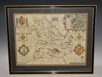
AN ORIGINAL ENGRAVED MAP OF DORSET. Dorsetshire Dorsetshyre with the Shyre-towne Dorchester described, as also the Armes of such noble families as have bene honored with the Titles there of since the Normans conquest to this present. Anno 1610.
by DORSETSHIRE - SPEED, JOHN:
- Used
- Condition
- Used
- Quantity Available
- 1
- Seller
-
Dorchester, Dorset, United Kingdom
- Item Price
-
£330.00£14.95 shipping to USA
Show Details
Description:
Ca 1611 1st edition. Lg.map (engr.surface ca 51 cm x 37 cm). English text on verso. Framed in double sided glass Hogarth Frame, With Ivory Mount. Frame Size 25.5 x 21 inches In generally good condition. Lower left edge of frame a bit chipped. Rear glass is broken. Lightly sunned down centre fold. A few old worming holes on lower section of map, and closed tear with on tape repair on verso. A RARE map, low price due to faults. An attractive and decorative map with inset town plan of Dorchester, sea monsters, ships and elaborate coat of arms. The maps by J.Speed are "the best known and most popular of all English county maps"(Tooley). Text in English to verso with page numbers 17-18. Dorsetshire spelt Dorcester-Shire.
Item Price
£330.00
£14.95
shipping to USA

ORIGINAL ENGRAVED ANTIQUE MAP OF ENGLAND & WALES
by Walker
- Used
- Condition
- Used
- Quantity Available
- 1
- Seller
-
Dorchester, Dorset, United Kingdom
- Item Price
-
£66.00£14.95 shipping to USA
Show Details
Description:
Engraved for Walker’s Geograpghy Ca 1798. Hand coloured. Unmounted. In very good condition. Two neat faint folds. Very Clean & strong impression. Engraved surface Size 21cm x 18cm
Item Price
£66.00
£14.95
shipping to USA
More Photos
AN ORIGINAL ENGRAVED MAP OF BREKNOKE (both shire and town) Brecknockshire An attractive and decorative map with inset town plan of Breknoke, scales of English Miles, and 3 elaborate coat of arms. Title cartouche Engraved by Hondius.
by SPEED, JOHN:
- Used
- Condition
- Used
- Quantity Available
- 1
- Seller
-
Dorchester, Dorset, United Kingdom
- Item Price
-
£495.00£14.95 shipping to USA
Show Details
Description:
Bassett & Chiswell, 1676. Lg. map (engr.surface ca 51 cm x 37 cm). English text on verso. A nice example of this decorative County map by John Speed. Includes inset of Breknoke with the coat of arms for James Butler, Earle of Breknoke and three other coasts of arms, plus and early battle scene. FRAMED in double Glazed Hogarth Frame. Strong impression with the detail in the engraving clear and black. Overall in very good condition. Imprint on left- hand corner, giving publishers: “Performed by John Speede. And are to be solde by Thomas Bassett in Fleetstreet and Richard Chiswell in St Pauls Churchyard”. The maps by J.Speed are "the best known and most popular of all English county maps" (Tooley). Despite competition from maps of the English counties by Blaeu and Jansson, Speed’ maps were “bestsellers”. A beautifully coloured map of the historic county of Brecknockshire, with an inset map of the city of Brecon.
Item Price
£495.00
£14.95
shipping to USA

ORIGINAL ENGRAVED ANTIQUE MAP OF SURREY
by Slater, I.
- Used
- Condition
- Used
- Quantity Available
- 1
- Seller
-
Dorchester, Dorset, United Kingdom
- Item Price
-
£44.00£14.95 shipping to USA
Show Details
Description:
Slater, I. Fleet Street Ca 1840. Hand coloured Unmounted, with Nice vignette top left corner of St. Saviours Church Southwalk In very good condition. Very Clean & strong impression. Engraved surface Size 36 x 23cm
Item Price
£44.00
£14.95
shipping to USA

ORIGINAL ENGRAVED MAP OF BEDFORDSHIRE. Engraved for LEWIS's “Topographical Dictionary” and drawn by R. Creighton. From: “AN ATLAS comprising Maps of the Several Counties, divided into Unions….”.
by WALKER, J. & C. / LEWIS:
- Used
- Condition
- Used
- Quantity Available
- 1
- Seller
-
Dorchester, Dorset, United Kingdom
- Item Price
-
£17.00£14.95 shipping to USA
Show Details
Description:
Published by S.Lewis & Co. Ca 1842.. Overall size: 11 x 8.5 inches In good condition. A few light marks in margins. Outline Hand Colouring. The Map shows the principal roads, rivers, railways and canals. The Walker brothers were publishers and engravers.
Item Price
£17.00
£14.95
shipping to USA

More Photos
ORIGINAL ENGRAVED MAP OF Middlesex. Detailed map in which is laid down every Parish & Place containing upwards of 40 houses; table of information on the county.
by G & W B Whittaker
- Used
- Condition
- Used
- Quantity Available
- 1
- Seller
-
Dorchester, Dorset, United Kingdom
- Item Price
-
£17.00£14.95 shipping to USA
Show Details
Description:
Published by G & W B Whittaker. 1824. Overall size: ca. 5.5 x 8.5 inches PLATE XXII In very good condition. Small tape on both side margins. Antique engraved copperplate map with hand colouring;
Item Price
£17.00
£14.95
shipping to USA

ORIGINAL POSTER. High Speed Steel Twist Drills.
- Used
- Condition
- Used
- Quantity Available
- 1
- Seller
-
Dorchester, Dorset, United Kingdom
- Item Price
-
£17.00£14.95 shipping to USA
Show Details
Description:
Balfour Darwins Limited No Date. Large Poster measure 84 cms (33 inches) X 59 cms (23 inches) Full colour. In very good condition. Lightly mark on top edge. Tanning to bottom edge. A few small tears to edges. Ideal for Work Shop/Shed.
Item Price
£17.00
£14.95
shipping to USA

ORIGINAL POSTER. Fibre Building Boards. 1 - Types & Sizes
- Used
- Condition
- Used
- Quantity Available
- 1
- Seller
-
Dorchester, Dorset, United Kingdom
- Item Price
-
£15.00£14.95 shipping to USA
Show Details
Description:
Sir Joseph Causton & Sons Ltd FIDOR Fibre Building Board Development Organisation Limited. Large Poster measure 76 cms (30 inches) X 56 cms (22 inches) Full colour. In very good condition. Some rubbing to top left edge. Ideal for Work Shop/Shed.
Item Price
£15.00
£14.95
shipping to USA

More Photos
ORIGINAL ENGRAVED ANTIQUE MAP OF CAMBRIDGESHIRE. “A New Map of Cambridgeshire, Drawn from the Latest Authorities.”
by CONDER, T.:
- Used
- Condition
- Used
- Quantity Available
- 1
- Seller
-
Dorchester, Dorset, United Kingdom
- Item Price
-
£28.00£14.95 shipping to USA
Show Details
Description:
London, T. Conder Sculpt., Kings Arms, 16. Paternoster Row, ca1700. Original engraved map, Unframed. Engraved surface 19.5 x 16 cm (7.5 x 6 ins). Overall 22 x 17.5 cm (8.5 x 7 ins.) In very good condition. Some minor foxing spots around edges else a very good clean and bright example. The title of the county is contained in an ornamental cartouche, coloured green. With additional remarks, County Crest, and scale in miles.
Item Price
£28.00
£14.95
shipping to USA

ORIGINAL POSTER. Combination Planes. Nos. 50 & 50s
- Used
- Condition
- Used
- Quantity Available
- 1
- Seller
-
Dorchester, Dorset, United Kingdom
- Item Price
-
£15.00£14.95 shipping to USA
Show Details
Description:
Stanley Works (GB) Ltd . Large Poster measure 75 cms (29.5 inches) X 49 cms (19.5 inches) Full colour. In very good condition. Ideal for Work Shop/Shed.
Item Price
£15.00
£14.95
shipping to USA

ORIGINAL LITHOGRAPH by LIB: SIGNOR PIETRO MASCAGNI, “Cavalleria Rusticana.”. 24/8/1893. (Music)
by VANITY FAIR: A Weekly Show:
- Used
- Condition
- Used
- Quantity Available
- 1
- Seller
-
Dorchester, Dorset, United Kingdom
- Item Price
-
£26.00£14.95 shipping to USA
Show Details
Description:
Vincent Brooks, Day & Son Ltd. 1893. Size of printed surface: ca. 33 cm x 20 cm. Coloured as published. Very good. With a couple of small marks at top of border. Top right corner slightly creased. In ivory mount with gilt line. Pietro Mascagni (December 7, 1863 – August 2, 1945) was an Italian composer most noted for his operas. His 1890 masterpiece, Cavalleria rusticana, caused one of the greatest sensations in opera history and singlehandedly ushered in the Verismo movement in Italian dramatic music.
Item Price
£26.00
£14.95
shipping to USA

More Photos
ORIGINAL WATERCOLOUR “Dewlish” Dorchester Dorset SIGNED
by Hazel Wainwright
- Used
- Condition
- Used
- Quantity Available
- 1
- Seller
-
Dorchester, Dorset, United Kingdom
- Item Price
-
£55.00£14.95 shipping to USA
Show Details
Description:
1970 . Size of picture: 11.5 x 9.5 inches. In a grey wooden frame with Glass front. In very good condition. Really nice & bright colours. 20th century artist Hazel Wainwright
Item Price
£55.00
£14.95
shipping to USA

ORIGINAL ENGRAVED HAND-COLOURED MAP OF Cornwall. Prepared for “Hobson’s Fox-Hunting Atlas.”
by WALKER, J. & C.;
- Used
- Condition
- Used
- Quantity Available
- 1
- Seller
-
Dorchester, Dorset, United Kingdom
- Item Price
-
£35.00£14.95 shipping to USA
Show Details
Description:
London J. & C. Walker. Ca 1840.. LARGE MAP. Double Page Map with centre fold. Size of engraved surface: 15 x 12.5 inches. Overall size: 16.5 x 14 inches. In very good condition. A couple of very small marks, slight fading around edges. Else very clean and bright. - The Map shows the main hunting grounds of the county and their meeting places, also the principal roads, rivers, railways and canals. The Walker brothers were publishers and engravers. Later Hand Colouring. With Meeting Places of FoxHounds, Boroughs, Divisions, and Hundreds.
Item Price
£35.00
£14.95
shipping to USA

ORIGINAL ENGRAVED MAP OF HUNTINGDONSHIRE. From Cary’s “New and Correct English Atlas”. Exhibiting all the Direct and principal Cross Roads, Cities, Towns, and most considerable Villages, Parks, Rivers, navigable Canals, etc.;
by CARY, JOHN:
- Used
- Condition
- Used
- Quantity Available
- 1
- Seller
-
Dorchester, Dorset, United Kingdom
- Item Price
-
£35.00£14.95 shipping to USA
Show Details
Description:
1787. Framed size approx 13 x 15 inches. Size within mount approx 8.5 x 10.5 inches. In gold and black wood frame behind glass, with dark maroon mount. In very good condition. Else a very bright and clean example. Nice subtle later professional hand-colouring. Compass indicator. Scale of Miles.
Item Price
£35.00
£14.95
shipping to USA

More Photos
ORIGINAL New Map of the Isle of Man. Miniature map
by Best Authorities
- Used
- Condition
- Used
- Quantity Available
- 1
- Seller
-
Dorchester, Dorset, United Kingdom
- Item Price
-
£60.00£14.95 shipping to USA
Show Details
Description:
London, Best Authorities 1735. Held in small wooden frame and glass to front. Engraved Size 9.5cm x 7.5cm Frame Size 16.5cm x 11.5cm In very good condition. Hand coloured.
Item Price
£60.00
£14.95
shipping to USA

Didn’t find what you’re looking for?
Try adding this search to your want list. Millions of books are added to our site everyday and when we find one that matches your search, we’ll send you an email. Best of all, it’s free.
Add to Want List

Are you a frequent reader or book collector?
Join the Bibliophile's Club and save 10% on every purchase, every day — up to $20 savings per order!

Social Responsibility
Did you know that since 2004, Biblio has used its profits to build 16 public libraries in rural villages of South America?
