Description:
Stanley Works (GB) Ltd . Large Poster measure 75 cms (29.5 inches) X 49 cms (19.5 inches) Full colour. In very good condition. Ideal for Work Shop/Shed.
Search Results: Titles starting with O from The Antique Map & Bookshop
You searched for:
- Bookseller inventory: The Antique Map & Bookshop (titles starting with O)
- Bookseller: The Antique Map & Bookshop
Results 1 - 20 of 545

ORIGINAL POSTER. Combination Planes. Nos. 50 & 50s
- Used
- Condition
- Used
- Quantity Available
- 1
- Seller
-
Dorchester, Dorset, United Kingdom
- Item Price
-
£15.00£14.95 shipping to USA
Show Details
Item Price
£15.00
£14.95
shipping to USA

More Photos
ORIGINAL ENGRAVED MAP OF Dorsetshire. Engraved for LEWIS's “Topographical Dictionary” and drawn by R. Creighton. From: “AN ATLAS comprising Maps of the Several Counties, divided into Unions….”.
by DORSETSHIRE - WALKER, J. & C. / LEWIS:
- Used
- Condition
- Used
- Quantity Available
- 1
- Seller
-
Dorchester, Dorset, United Kingdom
- Item Price
-
£28.00£14.95 shipping to USA
Show Details
Description:
Published by S.Lewis & Co. 1842. Size approx 12.5 x 9 inches. In very good condition. Some tanning to edges around mount. Hand-coloured district outlines. The Map shows the principal roads, rivers, railways and canals. The Walker brothers were publishers and engravers. Their "British Atlas", published first in 1837 was re-issued until 1852.
Item Price
£28.00
£14.95
shipping to USA
More Photos
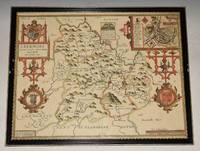
AN ORIGINAL ENGRAVED MAP OF BREKNOKE (both shire and town) Brecknockshire An attractive and decorative map with inset town plan of Breknoke, scales of English Miles, and 3 elaborate coat of arms. Title cartouche Engraved by Hondius.
by SPEED, JOHN:
- Used
- Condition
- Used
- Quantity Available
- 1
- Seller
-
Dorchester, Dorset, United Kingdom
- Item Price
-
£325.00£14.95 shipping to USA
Show Details
Description:
Sudbury & George Humbell 1610-1612. Engraved surface 20 x 15.50 inches. Frame Size 26.5 x 21.50 inches Attractive hand-colouring. A nice example of this decorative County map by John Speed. Includes inset of Breknoke with the coat of arms for James Butler, Earle of Breknoke and three other coasts of arms, plus and early battle scene. FRAMED in Glazed Hogarth Frame. Strong impression with the detail in the engraving clear and black. Frame has a few small chips. Overall in very good condition. Imprint on left- hand corner, giving publishers: “Performed by John Speede. And are to be solde by Sudbury & George Humbell”. The maps by J.Speed are "the best known and most popular of all English county maps" (Tooley). Despite competition from maps of the English counties by Blaeu and Jansson, Speed’ maps were “bestsellers”. A beautifully coloured map of the historic county of Brecknockshire, with an inset map of the city of Brecon.
Item Price
£325.00
£14.95
shipping to USA

More Photos
ORIGINAL ENGRAVED ANTIQUE MAP OF SURREY
by Seller Grose
- Used
- Condition
- Used
- Quantity Available
- 1
- Seller
-
Dorchester, Dorset, United Kingdom
- Item Price
-
£31.00£14.95 shipping to USA
Show Details
Description:
Ca 1809. Attractive later Hand colouring. In very good condition. Very Clean & strong impression. Engraved surface 14.5cm x 12cm. Text below. Page Size 19.5cm x 27cm
Item Price
£31.00
£14.95
shipping to USA

ORIGINAL ENGRAVED ANTIQUE MAP OF SURREY
by Pass, J.
- Used
- Condition
- Used
- Quantity Available
- 1
- Seller
-
Dorchester, Dorset, United Kingdom
- Item Price
-
£29.00£14.95 shipping to USA
Show Details
Description:
Published for the Encyclopedia Londinensis 1827. Hand coloured Unmounted. In very good condition. Very Clean & strong impression. Engraved surface Size 24.5 x 20cm
Item Price
£29.00
£14.95
shipping to USA

ORIGINAL ENGRAVED ANTIQUE MAP OF SURREY
by Hall, Sidney
- Used
- first
- Condition
- Used
- Quantity Available
- 1
- Seller
-
Dorchester, Dorset, United Kingdom
- Item Price
-
£18.00£14.95 shipping to USA
Show Details
Description:
Published by Chapman & Hall 1831 1st edition. Uncoloured Unmounted. In very good condition. With a few light folds. Very Clean & strong impression. Engraved surface Size 24 x 19cm
Item Price
£18.00
£14.95
shipping to USA

More Photos
ORIGINAL ENGRAVED MAP OF “BERKSHIRE BERCHERIA Barkshire”.
by BLAEU, JOHN (1596 - 1673):
- Used
- Condition
- Used
- Quantity Available
- 1
- Seller
-
Dorchester, Dorset, United Kingdom
- Item Price
-
£215.00£14.95 shipping to USA
Show Details
Description:
1648. Large double sided map (engraved surface 19.5 x 15 inches). Gold tinted black hardwood Frame, with glass front & back. Frame Size 27 x 23.5 inches. Pleasing hand-colouring. An attractive and decorative map with elaborate title-cartouche and coats of arms. There is very light publishers centrefold. Strong impression. Overall in very good condition. Mount a little tanned, and in a wide black Hogarth frame, has some chipping. With DUTCH text on verso. One of the largest and most prolific map publishing houses of the 17th. century. The decorative merit and cartographic excellence of their maps are without doubt
Item Price
£215.00
£14.95
shipping to USA

ORIGINAL ENGRAVED MAP OF BEDFORDSHIRE. Engraved for LEWIS's “Topographical Dictionary” and drawn by R. Creighton. From: “AN ATLAS comprising Maps of the Several Counties, divided into Unions….”.
by WALKER, J. & C. / LEWIS:
- Used
- Condition
- Used
- Quantity Available
- 1
- Seller
-
Dorchester, Dorset, United Kingdom
- Item Price
-
£17.00£14.95 shipping to USA
Show Details
Description:
Published by S.Lewis & Co. Ca 1842.. Overall size: 11 x 8.5 inches In good condition. A few light marks in margins. Outline Hand Colouring. The Map shows the principal roads, rivers, railways and canals. The Walker brothers were publishers and engravers.
Item Price
£17.00
£14.95
shipping to USA

More Photos
ORIGINAL ENGRAVED ANTIQUE MAP OF CAMBRIDGESHIRE. “A New Map of Cambridgeshire, Drawn from the Latest Authorities.”
by CONDER, T.:
- Used
- Condition
- Used
- Quantity Available
- 1
- Seller
-
Dorchester, Dorset, United Kingdom
- Item Price
-
£28.00£14.95 shipping to USA
Show Details
Description:
London, T. Conder Sculpt., Kings Arms, 16. Paternoster Row, ca1700. Original engraved map, Unframed. Engraved surface 19.5 x 16 cm (7.5 x 6 ins). Overall 22 x 17.5 cm (8.5 x 7 ins.) In very good condition. Some minor foxing spots around edges else a very good clean and bright example. The title of the county is contained in an ornamental cartouche, coloured green. With additional remarks, County Crest, and scale in miles.
Item Price
£28.00
£14.95
shipping to USA

ORIGINAL ENGRAVED ANTIQUE MAP OF SURREY & SUSSEX on the Reverse. A Modern MAP of SURREY & Sussex, Drawn from the latest Surveys; Corrected & Improved by ye best Authorities. J. Ellis Sculp
by Ellis, John
- Used
- first
- Condition
- Used
- Quantity Available
- 1
- Seller
-
Dorchester, Dorset, United Kingdom
- Item Price
-
£72.00£14.95 shipping to USA
Show Details
Description:
Printed for Robt. Sayer in Fleet Street, & Carington Bowles in St. Pauls Church yard. Ca 1766. Uncolouring. In very good condition. Faint mark on one margin edge. Very Clean & strong impression. Engraved surface 19.5cm x 25.5cm. The title of the county is contained in an ornamental cartouche. c.1765 (the first edition was published in 1765 & two further early editions followed in 1766). Although the map is undated the combined sellers imprint of Sayer and Bowles indicates that this is from an early edition of Ellis's English Atlas. There were several later editions which had slightly different sellers imprints with some having maps printed on both sides of the sheet.
Item Price
£72.00
£14.95
shipping to USA

ORIGINAL ENGRAVED ANTIQUE MAP OF SURREY Surrey Drawn from an Actual Survey and Regulated by Astronl. Observns. By T. Kitchin Geog.
by T. Kitchin
- Used
- Condition
- Used
- Quantity Available
- 1
- Seller
-
Dorchester, Dorset, United Kingdom
- Item Price
-
£39.00£14.95 shipping to USA
Show Details
Description:
Printed for England Illustrated Atlas Ca 1765. Hand coloured border lines. In very good condition. Very Clean & strong impression. Engraved surface 20cm x 25cm. The title of the county is contained in an ornamental cartouche.
Item Price
£39.00
£14.95
shipping to USA

More Photos
ORIGINAL ENGRAVED ANTIQUE MAP OF CAMBRIDGESHIRE. “A New Map of Cambridgeshire, Drawn from the Latest Authorities.”
by CONDER, T.:
- Used
- Condition
- Used
- Quantity Available
- 1
- Seller
-
Dorchester, Dorset, United Kingdom
- Item Price
-
£39.00£14.95 shipping to USA
Show Details
Description:
London, T. Conder Sculpt., Kings Arms, 16. Paternoster Row, ca1700. Original engraved map, Unframed. Engraved surface 19.5 x 16 cm (7.5 x 6 ins). In very good condition. Some tanning top edge else a very good clean and bright example. The title of the county is contained in an ornamental cartouche, hand coloured. With additional remarks, County Crest, and scale in miles.
Item Price
£39.00
£14.95
shipping to USA
More Photos
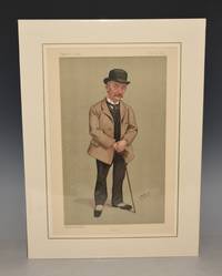
ORIGINAL LITHOGRAPH by SPY: THOMAS HARDY. “Tess”. 4.6.1892. (Literary)
by HARDY - VANITY FAIR: A Weekly Show:
- Used
- Condition
- Used
- Quantity Available
- 1
- Seller
-
Dorchester, Dorset, United Kingdom
- Item Price
-
£105.00£14.95 shipping to USA
Show Details
Description:
Vincent Brooks, Day & Son Ltd. 1892.. Size of printed surface: ca. 20 cm x 34 cm. Coloured as published. Held in ivory coloured mount with one gilt boarder line. Mount Size 33cm x 44cm In very good condition.
Item Price
£105.00
£14.95
shipping to USA

ORIGINAL ENGRAVED ANTIQUE MAP OF SURREY
by Slater, I.
- Used
- Condition
- Used
- Quantity Available
- 1
- Seller
-
Dorchester, Dorset, United Kingdom
- Item Price
-
£44.00£14.95 shipping to USA
Show Details
Description:
Slater, I. Fleet Street Ca 1840. Hand coloured Unmounted, with Nice vignette top left corner of St. Saviours Church Southwalk In very good condition. Very Clean & strong impression. Engraved surface Size 36 x 23cm
Item Price
£44.00
£14.95
shipping to USA

ORIGINAL ENGRAVED ANTIQUE MAP OF SURREY
by Archibald Fullarton, Engraved by R. Scott
- Used
- Condition
- Used
- Quantity Available
- 1
- Seller
-
Dorchester, Dorset, United Kingdom
- Item Price
-
£22.00£14.95 shipping to USA
Show Details
Description:
Published by Archibald Fullarton & Co. Ca 1834. Hand coloured Unmounted. In very good condition. A few light foxing marks on margins. Two neat folds. Strong impression. Engraved surface Size 24.5 x 19cm
Item Price
£22.00
£14.95
shipping to USA

ORIGINAL ENGRAVED MAP OF MOROCCO. Original antique Coloured map of MOROCCO from the Encyclopaedia Britannica - 9th Edition, Volume XVI Plate X
by W & A. K Johnston
- Used
- Condition
- Used
- Quantity Available
- 1
- Seller
-
Dorchester, Dorset, United Kingdom
- Item Price
-
£11.00£14.95 shipping to USA
Show Details
Description:
Published by Charles Scribner's Sons 1875. Overall size: 10.75 x 8.5 inches In very good condition. A few faint foxing spots.
Item Price
£11.00
£14.95
shipping to USA

ORIGINAL ENGRAVED MAP OF Dorsetshire. Engraved for LEWIS's “Topographical Dictionary” and drawn by R. Creighton. From: “AN ATLAS comprising Maps of the Several Counties, divided into Unions….”.
by DORSETSHIRE - WALKER, J. & C. / LEWIS:
- Used
- Condition
- Used
- Quantity Available
- 1
- Seller
-
Dorchester, Dorset, United Kingdom
- Item Price
-
£31.00£14.95 shipping to USA
Show Details
Description:
Published by S.Lewis & Co. Ca 1842.. Size of engraved surface: 19 cm x 23 cm. Overall size: ca. 32 cm x 25 cm. In good condition. A few light marks, & a couple of small nicks on edges. Later Hand Colouring. The Map shows the principal roads, rivers, railways and canals. The Walker brothers were publishers and engravers.
Item Price
£31.00
£14.95
shipping to USA

ORIGINAL ENGRAVED ANTIQUE MAP OF HUNTINGDONSHIRE.
by Hall, Sidney
- Used
- Condition
- Used
- Quantity Available
- 1
- Seller
-
Dorchester, Dorset, United Kingdom
- Item Price
-
£11.00£14.95 shipping to USA
Show Details
Description:
Published by Chapman & Hall No date 1831. Uncoloured Unmounted. Portrait In very good condition. Faintly tanned bottom left by county name. Strong impression. Engraved surface Size 24 x 19cm
Item Price
£11.00
£14.95
shipping to USA

ORIGINAL Vintage Wood Wooden Stencil Wall ART of Portrait of William Barnes, Dorset UNSIGNED
- Used
- Signed
- Condition
- Used
- Quantity Available
- 1
- Seller
-
Dorchester, Dorset, United Kingdom
- Item Price
-
£55.00£14.95 shipping to USA
Show Details
Description:
Undated. Size of Wooden Piece: 12 x 15 inches. UNSIGNED In very good condition.
Item Price
£55.00
£14.95
shipping to USA

ORIGINAL ENGRAVED MAP OF BRAZIL. Original antique Coloured map of BRAZIL from the Encyclopaedia Britannica - 9th Edition, Volume IV Plate XVII
by W & A. K Johnston
- Used
- Condition
- Used
- Quantity Available
- 1
- Seller
-
Dorchester, Dorset, United Kingdom
- Item Price
-
£11.00£14.95 shipping to USA
Show Details
Description:
Published by Charles Scribner's Sons 1875. Overall size: 10.75 x 8.5 inches In very good condition. A few faint foxing spots top margin.
Item Price
£11.00
£14.95
shipping to USA

Didn’t find what you’re looking for?
Try adding this search to your want list. Millions of books are added to our site everyday and when we find one that matches your search, we’ll send you an email. Best of all, it’s free.
Add to Want List

Are you a frequent reader or book collector?
Join the Bibliophile's Club and save 10% on every purchase, every day — up to $20 savings per order!

Social Responsibility
Did you know that since 2004, Biblio has used its profits to build 16 public libraries in rural villages of South America?
