Description:
Rand McNally & Co., 1898. Large lithograph, full printed color. F, bright. At height of railroad expansion (nearly all whistestops). Verso index and text applicable to map, including a table of "The American Tariff from 1791 to 1896". 48.5x65.5cm..
Search Results: Authors starting with R from The Prime Meridian: Antique Maps & Books
You searched for:
- Bookseller inventory: The Prime Meridian: Antique Maps & Books (authors starting with R)
- Bookseller: The Prime Meridian: Antique Maps & Books
Results 1 - 20 of 31

(Map of S. Carolina): Rand, McNally & Company's Indexed Atlas of the World (South Carolina)
by Rand, McNally
- Used
- Condition
- Used
- Quantity Available
- 1
- Seller
-
Crozet, Virginia, United States
- Item Price
-
£60.70£6.88 shipping to USA
Show Details
Item Price
£60.70
£6.88
shipping to USA
(Map of South Carolina): Rand, McNally & Co.'s Indexed Atlas of the World Map of South Carolina
by Rand, McNally
- Used
- Condition
- Used
- Quantity Available
- 1
- Seller
-
Crozet, Virginia, United States
- Item Price
-
£40.46£6.88 shipping to USA
Show Details
Description:
Rand, McNally & Co., Chicago, 1888. Full printed color lithograph, outline and divisional color. Very good railroad info. G, due to some marginal tears, esp. lower margin, one of which crosses neatline. Some marginal browning. Image clean and bright. 31.5x47cm..
Item Price
£40.46
£6.88
shipping to USA
(Map of N. Carolina): Rand McNally & Company's Indexed Atlas of the World (North Carolina)
by rand, McNally
- Used
- Condition
- Used
- Quantity Available
- 1
- Seller
-
Crozet, Virginia, United States
- Item Price
-
£60.70£6.88 shipping to USA
Show Details
Description:
Rand McNally & Co., Chicago, 1898. Large lithoraph, full printed color w/inset of "Western Portion of North carolina". Detailed w/ towns, railrroads, counties, topography. F, bright. Verso text applicable to map. Verso table of "Distribution of Population in the United States in acco rdance with Altitude 1880 and 1890". 48x65.5cm..
Item Price
£60.70
£6.88
shipping to USA
(Linen-Backed Map, Napoleon's final exile, military History): This Geographical Plan of the Island & Forts of Saint Helena is Dedicated By Permission to Field Marshal..Duke of Kent and Stratheam by.."
by Read, Lieut. R. P
- Used
- Condition
- Used
- Quantity Available
- 1
- Seller
-
Crozet, Virginia, United States
- Item Price
-
£1,416.28£6.88 shipping to USA
Show Details
Description:
London, 1816. Very good condition, early hand colored 16 panel linen backed map, with image measuring 16.75x22.5 inches. The date is approximate, as the initial issue of this map was in October of 1815, to capitalize commercially on Napoleon's exile to the island. On that first issue, based on Sellers map of the island in 1675 "Atlas Maritimus" (in turn taken from early Dutch mapmakers), the location of Napoleon's residence had been mislabelled (was indicated as the Plantation House). In this later issue, the error has been corrected, and both his earlier residence at The Briars, and subsequent Longwood residence are correctly labelled. This folds into a 6x4.75 inch gray card case (original) with the original title label recto, and small image of Napoleon lounging under a palm tree verso. There are a couple of small marginal verso stains on the verso, but none on the front of the case, and no stains on the map. The map is very attractive with sailing ships, and many interesting…
Read More Item Price
£1,416.28
£6.88
shipping to USA
(Lithographic Sketch, Redrawn; Spanish-Amercan War- Philippines): View from Siniloan of Insurgent Position a Navitac and of Road Taken By Capt. Mitchell
by Reeve, Lieut. H. M
- Used
- Condition
- Used
- Quantity Available
- 1
- Seller
-
Crozet, Virginia, United States
- Item Price
-
£32.37£6.88 shipping to USA
Show Details
Description:
Washington DC: US Government Printing Office, 1901. Fine, b&w small lithograph of a an insurgent position (with hut, walkway, fields, hills) during this conflict. The image measures 7x9.5 inches, with folds as issued..
Item Price
£32.37
£6.88
shipping to USA
(Tinted Lithograph): Surveying Party at Dinner
by T. Sinclair & Son (from Selfridge report)
- Used
- Condition
- Used
- Quantity Available
- 1
- Seller
-
Crozet, Virginia, United States
- Item Price
-
£20.23£6.88 shipping to USA
Show Details
Description:
T. SInclair & Son Lith., Philadelphia, c. 1874. Near fine tinted lithograph prepared specifically for Thos. Oliver Selfridge's "Reports of Explorations and Surveys to Ascertain the Practicability of a Ship-Canal Between the Atlantic and Pacific Oceans by the Way of the Isthmus of Darien." This re port was the forerunner of the contentious development of the Panama Canal, at a time when planners were leaning towards placement of this canal in Colombia, South America. The image is 17.5x25cm..
Item Price
£20.23
£6.88
shipping to USA
(Tinted Lithograph): Falls of Quebrada del Mar, Limon Bay
by T. Sinclair & Son (from Selfridge report)
- Used
- Condition
- Used
- Quantity Available
- 1
- Seller
-
Crozet, Virginia, United States
- Item Price
-
£16.19£6.88 shipping to USA
Show Details
Description:
T. SInclair & Son Lith., Philadelphia, c. 1874. Near fine tinted lithograph prepared specifically for Thos. Oliver Selfridge's "Reports of Explorations and Surveys to Ascertain the Practicability of a Ship-Canal Between the Atlantic and Pacific Oceans by the Way of the Isthmus of Darien." This re port was the forerunner of the contentious development of the Panama Canal, at a time when planners were leaning towards placement of this canal in Colombia, South America. The image is 17.5x25cm..
Item Price
£16.19
£6.88
shipping to USA
(Tinted Lithograph): Commander Selfridge on His Return Reconnaissance into the Interior of Darien
by T. Sinclair & Son (from Selfridge report)
- Used
- Condition
- Used
- Quantity Available
- 1
- Seller
-
Crozet, Virginia, United States
- Item Price
-
£20.23£6.88 shipping to USA
Show Details
Description:
T. SInclair & Son Lith., Philadelphia, c. 1874. VG+ tinted lithograph prepared specifically for Thos. Oliver Selfridge's "Reports of Explorations and Surveys to Ascertain the Practicability of a Ship-Canal Between the Atlantic and Pacific Oceans by the Way of the Isthmus of Darien." This report w as the forerunner of the contentious development of the Panama Canal, at a time when planners were leaning towards placement of this canal in Colombia, South America. The image is 17.5x25cm..
Item Price
£20.23
£6.88
shipping to USA
(Biography- Architecture, Engineering): Robert Mylne. Architect and Engineer 1733 to 1811
by Richardson, A. E
- Used
- Hardcover
- Condition
- Used
- Binding
- Hardcover
- Quantity Available
- 1
- Seller
-
Crozet, Virginia, United States
- Item Price
-
£44.51£6.88 shipping to USA
Show Details
Description:
London: B. T. Batsford Ltd., 1955. DJ good, with some chipping margins; price clipped. Cloth covers a bit rubbed, and some fading over spine. Interior excellent. Mylne was surveyor of St. Paul's Cathedral and Chief Engineer for the New River Company. This is a scholarly work. Numerous b&w illustrations. 220pp.. 8vo - over 7¾" - 9¾" tall.
Item Price
£44.51
£6.88
shipping to USA
(3 Sheet Map Middle East, Western Asia, India): Imperia Antiqua, pars Orientalis, pars Media, pars Occidentalis
by Bonne Rigobert
- Used
- Condition
- Used
- Quantity Available
- 1
- Seller
-
Crozet, Virginia, United States
- Item Price
-
£133.53£6.88 shipping to USA
Show Details
Description:
Paris: Hotel De Thou, Rue Des Poitevins, 1787. Near fine three-sheet map set, copperplate engravings, b&w as issued, each image measuring approximately 23 x 33 cm. Engraved by Gaspar André. These are sheets 5, 6 and 7 from Bonne and Desmarest's "Atlas Encyclpedique..." Several wind diagrams present. The eastern sheet shows India and "Taprobana" Island. The western sheet shows portions of northeastern Africa. .
Item Price
£133.53
£6.88
shipping to USA
(Two Map Set: Roman Empire, east and west sheets): Imperii Romani Distracta, pars Orientalis [and] pars Occidentalis
by Bonne Rigobert
- Used
- Condition
- Used
- Quantity Available
- 1
- Seller
-
Crozet, Virginia, United States
- Item Price
-
£109.26£6.88 shipping to USA
Show Details
Description:
Paris: Hotel De Thou, Rue Des Poitevins, 1787. Near fine, two sheet copperplate engraved set, plates 18 and 19, b&w as issued from the "Atlas Encyclopedique..." by Bonne and Desmarest. Engraved by Gaspar André. A nice wind rose is present on the lower left of sheet 18 (the western sheet). Each image measures approximately 23 x 33 cm..
Item Price
£109.26
£6.88
shipping to USA
(Map of Northern Hemisphere): Mappe - Monde, sur le Plan de L'Equateur, Hemisphere Septentrional
by Bonne Rigobert
- Used
- Condition
- Used
- Quantity Available
- 1
- Seller
-
Crozet, Virginia, United States
- Item Price
-
£109.26£6.88 shipping to USA
Show Details
Description:
Paris: Hotel De Thou, Rue Des Poitevins, 1787. Very good, copperplate engraved map, b&w as issued, with some generalized browning. Engraved by Gaspar André. Several tables with climactic information present, and a spherical represenation of climactic zones in the lower right corner. This is plate 22 from the "Atlas Encyclopedique..." by Bonne and Desmarest. The image measures approximately 23 X 33 cm..
Item Price
£109.26
£6.88
shipping to USA
(Map of Italy): Italie
by Bonne Rigobert
- Used
- Condition
- Used
- Quantity Available
- 1
- Seller
-
Crozet, Virginia, United States
- Item Price
-
£68.79£6.88 shipping to USA
Show Details
Description:
Paris: Hotel De Thou, Rue Des Poitevins, 1787. Near fine map of Italy from Bonne and Desmarest's "Atlas Encylopedique..." Engraved by Gaspar André. Prime meridians are Paris and the Isle de Fer. Nine separate scales. B&W, as issued. This is plate 51 from the atlas. The copperplate engraved image measures 33 x 23 cm. Sicily, Sardinia and Corsica are shown..
Item Price
£68.79
£6.88
shipping to USA
(Map of Spain and Portugal): Le Royaume D'Espagne et celui de Portugal
by Bonne Rigobert
- Used
- Condition
- Used
- Quantity Available
- 1
- Seller
-
Crozet, Virginia, United States
- Item Price
-
£68.79£6.88 shipping to USA
Show Details
Description:
Paris: Hotel De Thou, Rue Des Poitevins, 1787. Near fine copperplate, engraved map, b&w as issued. Engraved by Gaspar André. From Bonne and Desmarest's 1787 "Atlas Encyclopedique..." This is plate 44 from the atlas. Seven separate scales. Prime meridians Paris and Isle de Fer. The image measures 23 x 33 cm..
Item Price
£68.79
£6.88
shipping to USA
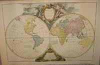
(Word Map): Orbis vetus in utrâque continente juxta mentem Sansonianam distinctus, nec non observationibus astronomicis redactus, accurante
by Robert de Vaugondy, Didier; Robert de Vaugondy, Gilles
- Used
- Condition
- Used
- Quantity Available
- 1
- Seller
-
Crozet, Virginia, United States
- Item Price
-
£1,533.62£6.88 shipping to USA
Show Details
Description:
Paris: apud autorem and Aut. Boudet, 1752. Very good, early hand color, wide margins on laid paper. This is a rather decorative double hemisphere (eastern and western) image.Two watermarks visible verso. Two cartouches upper (title) and lower (notes) central map. The date on the map is 1752, but this is from an "Atlas Universel..." ca. 1757. An image of the map appears in the online David Rumsey Map Collection. Each hemisphere is 35 cm (13.75 inches) in diameter, on a sheet measuring 53 x 83 cm (21 x 32 5 inches), including margins. (Ref: Pedley. Belle et utile, p. 135, no.13.). Map.
Item Price
£1,533.62
£6.88
shipping to USA
(Text on Use of Terrestrial and Celestial Globes): Usages Des Globes Celeste et Terrestre, Faits Par Ordre Du Roy, Par le S. Rober De Vaugondy, fils
by Robert de Vaugondy, Didier
- Used
- very good
- Hardcover
- Condition
- Used - Very Good
- Binding
- Hardcover
- Quantity Available
- 1
- Seller
-
Crozet, Virginia, United States
- Item Price
-
£768.84£6.88 shipping to USA
Show Details
Description:
Paris: Antoine Boudet, 1751. Interior VG+, with all 5 folding plates (Copernican and Ptolemaic astronomy, Ticho-Brahe system, armillary spheres, and the other 2 technical diagrams). Three pages (sheets) of dedication to King (Epitre). Preface xviii; 248 pp; 26 other pages with advertisements, tables, terms. It is curious that many references to this publication refer to title as "Usage...", although the title in our copy is clearly plural, as indicated in the title, and as listed in the Library of Congress online catalogue (entry 10000950). Nice contemporary leather covers, binding tight, raised bands with gilt lettering and design on spine. Some wear with scuffing to boards, but no serious damage. This is quite scarce, and is referenced in Pedley's "Bel et Utile" on the work of the Robert de Vaugondy family. This book is formally dedicated to the king, and was often given to purchasers of one or more of the family's globes. Boudet was a prominent publisher of the time (and…
Read More Item Price
£768.84
£6.88
shipping to USA
Francis Drake & Other Early Explorers Along the Pacific Coast
by Robertson, John W
- Used
- very good
- Hardcover
- Condition
- Used - Very Good
- Edition
- Limited
- Binding
- Hardcover
- Quantity Available
- 1
- Seller
-
Crozet, Virginia, United States
- Item Price
-
£182.09£6.88 shipping to USA
Show Details
Description:
San Francisco: The Grabhorn Press, 1927. VG, 4to. with 28 maps to supplement the text. There are sections on Cortez, the Jesuit surveys of the Baja, and on regional Native Americans from the perspective of early Span ish explorers. The slipcase is in good condition, with 2 small separations at the upper and lower edges (still functions as intended). This edition was limited to 1000 copies. The appendix includes Hakluyt's account of Drake's voyage and other period declarations. . Limited. Vellum Over Boards . Very Good/Good (slipcase). 4to - over 9¾" - 12" tall. Private Press.
Item Price
£182.09
£6.88
shipping to USA
Guide to Nantucket
by Robinson, JH
- Used
- very good
- Paperback
- Condition
- Used - Very Good
- Edition
- 5th
- Binding
- Paperback
- Quantity Available
- 1
- Seller
-
Crozet, Virginia, United States
- Item Price
-
£52.60£6.88 shipping to USA
Show Details
Description:
Nantucket: Robinson, 1928. VG, PB, with 63 pp text and many adds. Bound in map with one side "Nantucket County Massachusetts" (b&w 7.5x13 inches with folds as issued). Verso maps (smaller: 1. Nantucket Massachusetts 2. Steamboat Route, Lighthouses, Lightships). The small city plan has detailed street names. A few pencil marks on cover, but generally clean. Many b&w photographic reproductions of local sights in text. Author was a member of the Nantucket Historical Association. . 5th. Mass Market Paperback. Very Good/Very Good. 8vo - over 7¾" - 9¾" tall.
Item Price
£52.60
£6.88
shipping to USA
Antique Map Price Record & Handbook (6 vols: 1993, 1994, 1995, 1996, 1997-98, 1999-2000)
by Rosenthal, Jon K. (compiled and edited by)
- Used
- Hardcover
- Condition
- Used
- Binding
- Hardcover
- Quantity Available
- 1
- Seller
-
Crozet, Virginia, United States
- Item Price
-
£121.40£6.88 shipping to USA
Show Details
Description:
Amherst: Kimmel Publications. Internally all very good. Various paginations. Covers a bit worn (shelf wear) on a few of the volumes, but bindings tight. Two with small owners stamp on front pastedown. This was the extension of the old Jolly guide, and the Rosenthals had taken over in 1993, so this is a complete set of the publication during their tenure. There is a good bit of information for collectors in these volumes, with various prices on maps, reference sources, glossary of terms and more. The prices shown were compiled both from dealers catalogues and auctions.. Cloth. 8vo - over 7¾" - 9¾" tall.
Item Price
£121.40
£6.88
shipping to USA
(Map of Washington D.C.): Statistical Map No. 11. Showing the Schedule of Street Sweeping, City of Washington
by Rossell, WT
- Used
- first
- Condition
- Used
- Quantity Available
- 1
- Seller
-
Crozet, Virginia, United States
- Item Price
-
£36.42£6.88 shipping to USA
Show Details
Description:
US Govt. Printing Office, 52nd Congress (1st Sess.), HED 1 (Part7), Washington 1891. Fine w/small crease tears. Fragile paper. B&W detailed city map/street plan. From "Annual Reopor of the Commissioners of the District of Columbia for the Year Ended June 30, 1891". Color coded for number of times swept per week. 71x69cm..
Item Price
£36.42
£6.88
shipping to USA

Didn’t find what you’re looking for?
Try adding this search to your want list. Millions of books are added to our site everyday and when we find one that matches your search, we’ll send you an email. Best of all, it’s free.
Add to Want List

Are you a frequent reader or book collector?
Join the Bibliophile's Club and save 10% on every purchase, every day — up to $20 savings per order!

Social Responsibility
Did you know that since 2004, Biblio has used its profits to build 16 public libraries in rural villages of South America?
