Description:
Paris: Chez Eymery Fruger et Cie., 1837. Near fine condition, with orginal handcolored outlines. Very detailed depiction of the region bordering the Red Sea. The map is dated 1829, although it appeared in later atlas (above date approximate). The usual unobtrusive blindstamp is present. The map is from ATLAS UNIVERSEL DE GEOGRAPHIE ANCIENNE ET MODERNE. The image is 39x53cm (15.25x21 inches)..
Search Results: Authors starting with L from The Prime Meridian: Antique Maps & Books
You searched for:
- Bookseller inventory: The Prime Meridian: Antique Maps & Books (authors starting with L)
- Bookseller: The Prime Meridian: Antique Maps & Books
Results 1 - 20 of 78

(Map /Chart of Middle East- Red Sea Environs): Carte De L'Egypte, De La Nubie, De L'Abissinie, Du Kourdofan
by Lapie
- Used
- Condition
- Used
- Quantity Available
- 1
- Seller
-
Crozet, Virginia, United States
- Item Price
-
£76.63£6.86 shipping to USA
Show Details
Item Price
£76.63
£6.86
shipping to USA
(Map of Asia): Carte de L'Asie
by Lapie
- Used
- Condition
- Used
- Quantity Available
- 1
- Seller
-
Crozet, Virginia, United States
- Item Price
-
£181.48£6.86 shipping to USA
Show Details
Description:
Paris: Chez Eymery Fruger et Cie., 1837. Near fine large map of this region, on heavy paper with hand-colored outlines (as issued). The usual unobtrusive blindstamp is present. This map was first published c. 1832. This very attractive map is from ATLAS UNIVERSEL DE GEOGRAPHIE ANCIENNE ET MODERNE. The map is quite detailed for the times. The image is 39x53 cm (15.25x21 inches)..
Item Price
£181.48
£6.86
shipping to USA
(Map of Spain, Portugal): Carte de La Peninsule Comprenant L'Espagne et Le Portugal
by Lapie
- Used
- Condition
- Used
- Quantity Available
- 1
- Seller
-
Crozet, Virginia, United States
- Item Price
-
£76.63£6.86 shipping to USA
Show Details
Description:
Chez Eymery Fruger et Cie., Paris, c. 1837, 1837. Near fine condition with orginal handcolored outlines. Very detailed depiction of the Iberian peninsula. The map is dated 1831, although it appeared in later atlas (above date approximate). The usual unobtrusive blindstamp is present. The map is from ATLAS UNIVERSEL DE GEOGRAPHIE ANCIENNE ET MODERNE. The image is 39x53cm (15.25x21 inches)..
Item Price
£76.63
£6.86
shipping to USA
(Map of Greece): Carte de la Grece, et de L'Archipel
by Lapie
- Used
- Condition
- Used
- Quantity Available
- 1
- Seller
-
Crozet, Virginia, United States
- Item Price
-
£72.59£6.86 shipping to USA
Show Details
Description:
Eymery Fruger et Cie., Paris, c. 1837. Near fine large, attractive map on heavy paper with hand-colored outlines. Very detailed depiction of Greek islands at the time. The first issue of this map was printed c. 1832. The usual unobtrusive blindstamp is present. The map is from ATLAS UNIV ERSEL DE GEOGRAPHIE ANCIENNE ET MODERNE. The image is 39x53cm (15.25x21 inches)..
Item Price
£72.59
£6.86
shipping to USA
(Map / Chart- Asia, Middle East; Empire Alexander the Great) Carte De L'Empire D'Alexandre
by Lapie
- Used
- Condition
- Used
- Quantity Available
- 1
- Seller
-
Crozet, Virginia, United States
- Item Price
-
£60.50£6.86 shipping to USA
Show Details
Description:
Paris: Chez Eymery Fruger et Cie., 1837. Near fine condition with orginal handcolored outlines. Very detailed depiction of the region of then Asia Major covering the vast expanse of Alexander's empire. The map is dated 1832, although it appeared in later atlas (above date approximate). The usual unobtrusive blindstamp is present. The map is from ATLAS UNIVERSEL DE GEOGRAPHIE ANCIENNE ET MODERNE. The image is 39x53cm (15.25x21 inches)..
Item Price
£60.50
£6.86
shipping to USA
(Map of Egypt and Syria): Carte de la Syrie et de L'Egypte Anciennes
by Lapie
- Used
- Condition
- Used
- Quantity Available
- 1
- Seller
-
Crozet, Virginia, United States
- Item Price
-
£96.79£6.86 shipping to USA
Show Details
Description:
Chez Eymery Fruger et Cie., Paris, c. 1837. Near fine large map of this region, on heavy paper with hand-colored outlines (as issued). The usual unobtrusive blindstamp is present. This map was first published c. 1833. This very attractive map is from ATLAS UNIVERSEL DE GEOGRAPHIE ANCIENNE ET MODERNE. The map is quite detailed for the times. The image is 53x39 cm (21x15.25 inches)..
Item Price
£96.79
£6.86
shipping to USA
(Map of World- Hemispheric): Mappe-Monde en Deux Hemispheres
by Lapie
- Used
- Condition
- Used
- Quantity Available
- 1
- Seller
-
Crozet, Virginia, United States
- Item Price
-
£201.65£6.86 shipping to USA
Show Details
Description:
Paris: Chez Eymery Fruger et Cie., 1837. Near fine large map of the world, on heavy paper with hand-colored outlines (as issued). The usual unobtrusive blindstamp is present. This map was first published c. 1831. This very attractive map is from ATLAS UNIVERSEL DE GEOGRAPHIE ANCIENNE ET MO DERNE. The map is quite detailed for the times. The image is 39x53 cm (15.25x21 inches)..
Item Price
£201.65
£6.86
shipping to USA
(Map of Switzerland, Sweden): Carte de la Suisse ou Helvetie
by Lapie
- Used
- Condition
- Used
- Quantity Available
- 1
- Seller
-
Crozet, Virginia, United States
- Item Price
-
£100.82£6.86 shipping to USA
Show Details
Description:
Chez Eymery Fruger et Cie., Paris, c. 1837. Near fine map on double folio sheet with original outline color (at bit more contrast than some). There is substantial topographical detail. This has the usual unobtrusive blindstamp. This was first published c. 1830, and are found in ATLAS UNIVERSE L DE GEOGRAPHIE ANCIENNE ET MODERNE. This is a handsome map on heavy paper measuring 39x52cm (15.25x20.5 inches)..
Item Price
£100.82
£6.86
shipping to USA
(Map of Palestine-- Holy Land): Carte de la Palestine ou Terre Sainte
by Lapie
- Used
- Condition
- Used
- Quantity Available
- 1
- Seller
-
Crozet, Virginia, United States
- Item Price
-
£96.79£6.86 shipping to USA
Show Details
Description:
Chez Eymery Fruger et Cie., Paris, c. 1837. Near fine large map of this region, on heavy paper with hand-colored outlines (as issued). The usual unobtrusive blindstamp is present. This map was first published c. 1833. This very attractive map is from ATLAS UNIVERSEL DE GEOGRAPHIE ANCIENNE ET MODERNE. The map is quite detailed for the times. The image is 53x39 cm (21x15.25 inches)..
Item Price
£96.79
£6.86
shipping to USA
(Map of England, Scotland, Wales, Ireland): Carte des Iles Britanniques comprenant L'Angleterre, L'Ecosse et L'Irlande
by Lapie
- Used
- Condition
- Used
- Quantity Available
- 1
- Seller
-
Crozet, Virginia, United States
- Item Price
-
£120.99£6.86 shipping to USA
Show Details
Description:
Paris: Chez Eymery Fruger et Cie., 1837. VG large map on heavy paper with hand-colored outlines. A right marginal centerfold tear, not affecting image, has been repaired on verso with archival tape. Quite detailed for the times. The first issue of this map was printed c. 1829. The usual un obtrusive blindstamp is present. The map is from ATLAS UNIVERSEL DE GEOGRAPHIE ANCIENNE ET MODERNE. The image is 53x39cm (21x15.25 inches)..
Item Price
£120.99
£6.86
shipping to USA
(Map of Australia and Polynesia): Carte de L'Oceanie Contenant L'Australie, La Polynesie et Les Iles Asiatiques
by Lapie
- Used
- Condition
- Used
- Quantity Available
- 1
- Seller
-
Crozet, Virginia, United States
- Item Price
-
£221.82£6.86 shipping to USA
Show Details
Description:
Paris: Chez Eymery Fruger et Cie., 1837. Large map (fine condition) of this region, on heavy paper with hand-colored outlines (as issued). This map was first published c. 1829, and centers on Australia. This particular edition was engraved by Lallemand. This very attractive map is from ATLAS UNIVERSEL DE GEOGRAPHIE ANCIENNE ET MODERNE. The map in cludes the Philippines and New Guinea. The image is 39x53 cm (15.25x21 inches)..
Item Price
£221.82
£6.86
shipping to USA
(Map / Chart- Europe, Asia- Roman Empire): Carte De L'Empire Romain
by Lapie
- Used
- Condition
- Used
- Quantity Available
- 1
- Seller
-
Crozet, Virginia, United States
- Item Price
-
£60.50£6.86 shipping to USA
Show Details
Description:
Paris: Chez Eymery Fruger et Cie., 1837. Very good condition, slight foxing at margins (very little visual impact), with orginal handcolored outlines. Very detailed depiction of the region of Europe and Asia, with the vast expanse of the Roman empire. The map is dated 1832, although it appeared in later atlas (above date approximate). The usual unobtrusive blindstamp is present. The map is from ATLAS UNIVERSEL DE GEOGRAPHIE ANCIENNE ET MODERNE. The image is 39x53cm (15.25x21 inches)..
Item Price
£60.50
£6.86
shipping to USA
(Map of World- Mercator): Mappe-Monde sur la Projection de Mercator
by Lapie
- Used
- Condition
- Used
- Quantity Available
- 1
- Seller
-
Crozet, Virginia, United States
- Item Price
-
£201.65£6.86 shipping to USA
Show Details
Description:
Paris: Chez Eymery Fruger et Cie., 1837. Near fine large map of this region, on heavy paper with hand-colored outlines (as issued). The usual unobtrusive blindstamp is present. This map was first published c. 1832. This very attractive map is from ATLAS UNIVERSEL DE GEOGRAPHIE ANCIENNE ET MODERNE. The map is quite detailed for the times. The image is 39x53 cm (15.25x21 inches)..
Item Price
£201.65
£6.86
shipping to USA
(Map of North America): Carte de L'Amerique Septentrionale
by Lapie
- Used
- Condition
- Used
- Quantity Available
- 1
- Seller
-
Crozet, Virginia, United States
- Item Price
-
£181.48£6.86 shipping to USA
Show Details
Description:
Paris: Chez Eymery Fruger et Cie., 1837. Near fine large, detailed map of North America at the time, with hand-colored outlines on heavy paper from the ATLAS UNIVERSEL DE GEOGRAPHIE ANCIENNE ET MODERNE. Includes Gulf of Mexico with Greater and Lesser Antilles. Inset of Bering Sea and Aleut ian Islands. This plate was first published in 1830. The usual unobtrusive blindstamp is present. A very attractive plate measuring 53x39cm (21x15.5 inches)..
Item Price
£181.48
£6.86
shipping to USA
(Celestial Zodiac): Planispheres Celestes
by Lapie
- Used
- Condition
- Used
- Quantity Available
- 1
- Seller
-
Crozet, Virginia, United States
- Item Price
-
£120.99£6.86 shipping to USA
Show Details
Description:
Paris: Chez Eymery Fruger et Cie., 1837. Near fine large, b&w detailed constellation chart on heavy paper from the ATLAS UNIVERSEL DE GEOGRAPHIE ANCIENNE ET MODERNE. This plate was engraved by Lallemand in 1828 and first published in 1830. A very attractive double-hemispheric plate plate measuring 33x54cm (13x21.25 inches)..
Item Price
£120.99
£6.86
shipping to USA
(Maps of Europe- 4 map set; 2 sheets): 1.Carte de L'Europe sous Charlemagne vers l'an 800 2. Carte de L'Europe sous Charles-Quint...1500 3. Carte de L'Europe en 1789 4. Carte de L'Europe en 1813
by Lapie
- Used
- Condition
- Used
- Quantity Available
- 1
- Seller
-
Crozet, Virginia, United States
- Item Price
-
£157.29£6.86 shipping to USA
Show Details
Description:
Paris: Chez Eymery Fruger et Cie., 1837. Near fine set of 4 maps on 2 double folio sheets with original outline color. These have the usual unobtrusive blindstamp. These were first published c. 1831, and are found in ATLAS UNIVERSEL DE GEOGRAPHIE ANCIENNE ET MODERNE. They are very handsome maps on heavy paper, with each single image measuring 27x39cm (10.5x15.5 inches)..
Item Price
£157.29
£6.86
shipping to USA
(Map of Scandinavia): Carter De La Scandinavie...Les Royaumes De Suede, De Norwige et De Danemark
by Lapie
- Used
- Condition
- Used
- Quantity Available
- 1
- Seller
-
Crozet, Virginia, United States
- Item Price
-
£100.82£6.86 shipping to USA
Show Details
Description:
Paris: Chez Eymery Fruger et Cie., 1837. Near fine, double-folio size map with original hand colored outlines on heavy paper, with usual unobtrusive blindstamp. Includes Sweden, Denmark, Finland, Norway, Lapland and surrounding regions. This image was first published c. 1830, and appears in ATLAS UNIVERSEL DE GEOGRAPHIE ANCIENNE ET MODERNE. This is a handsome map, measuring 53x39cm (21x15.5 inches). .
Item Price
£100.82
£6.86
shipping to USA

(Atlas, Military Forts- 89 plans): Recueil Des Fortifications Forts et Ports De Mer De France lave Au Pinceau
by Le Rouge, George Louis
- Used
- Hardcover
- Condition
- Used
- Binding
- Hardcover
- Quantity Available
- 1
- Seller
-
Crozet, Virginia, United States
- Item Price
-
£967.92£6.86 shipping to USA
Show Details
Description:
Paris (Rue des Augustins): le Rouge , 1760. Contemporary marbled cloth boards, rebacked with banded leather spine and gilt-lettering. All 89 plates, including American ports (Quebec, Louisbourg, Nouvelle orleans, Fort Dauphin, Cayenne, Ville Marie), plus Table (index) at rear. These are b&w (as issued) copperplate engravings, on laid paper, all in very good or better condition. Le Rouge was trained as a military engineer, but did quite a number of cartographic works, often with a military slant, between 1740-1780 (see Moreland & Bannister, ANTIQUE MAPS). Listed as Phillips' entry 2975. A rather uncommon small atlas. Neat owners signatures.. 8vo - over 7¾" - 9¾" tall.
Item Price
£967.92
£6.86
shipping to USA
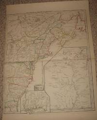
(Map, Revolutionary War Era, Colonial America): Theatre de la Guerre en Amerique
by Le Rouge, George Louis
- Used
- very good
- Condition
- Used - Very Good
- Quantity Available
- 1
- Seller
-
Crozet, Virginia, United States
- Item Price
-
£2,903.76£6.86 shipping to USA
Show Details
Description:
Paris: le Rouge, 1777. Very good/excellent, hand colored outlines, trimmed a bit close at margin (due to binding in prior Le Rouge atlas, "Atlas Ameriquain Septentrional..."). Image measuring 62 x 50 cm (24 x 20 inches). This is a clean impression on heavy paper. Three insets: Louisiane, southeast coastal region (Floride), Sault du Niagra. "Par le Sr. le Rouge, ingenieur geographe du Roy." appears after title in upper margin. This is McCorkle entry 777.14, without the "Corrigee...M. Hawkins...". Apparently Le Rouge reworked his early map (Canada et Louisane..) of 1755, and changed the title for this work (McCorkle entry 755.23). Not in Nebenzahl, although several other maps from this atlas appear in the references. The map is cataloged in OCLC. . Very Good. Map.
Item Price
£2,903.76
£6.86
shipping to USA
(Map of Asia): L'Asie D'Apres Les Voyageurs Modernes
by Le Sage, A. (Comte De Las Casas
- Used
- Condition
- Used
- Quantity Available
- 1
- Seller
-
Crozet, Virginia, United States
- Item Price
-
£141.16£6.86 shipping to USA
Show Details
Description:
Paris: P. Didot, 1814. VG (very small chip out of lower margin, away from neatline and text), with a lot of textual detail on the map plate, including major regional confederations. Heavy paper, double elephant folio sheet, original hand color. This handsome map has nicely color-coded geopolitical divisions. Le Sage was a pseudonym for Emmanuel, Comte de las Casas. These maps were intellectual forerunners of the well know Carey & Lea atlases, which were first issued in 1822. The image measures 12.5x13.5 inches (32x34cm). The full letterpress plate measures 19.5x25 inches (50x64cm). This map was from the 1814 edition of "ATLAS HISTORIQUE, Genealogique, Chronologique, et Geographique, Par A. LE SAGE"..
Item Price
£141.16
£6.86
shipping to USA

Didn’t find what you’re looking for?
Try adding this search to your want list. Millions of books are added to our site everyday and when we find one that matches your search, we’ll send you an email. Best of all, it’s free.
Add to Want List

Are you a frequent reader or book collector?
Join the Bibliophile's Club and save 10% on every purchase, every day — up to $20 savings per order!

Social Responsibility
Did you know that since 2004, Biblio has used its profits to build 16 public libraries in rural villages of South America?
