Description:
London,: at Tycho Brahe's Head, No 60. in Fleet-Street,, [c1775 or earlier].. 216 by 273mm. (8.5 by 10.75 inches).. Prints,""George Adams, Mathematical Instrument-Maker to his Majesty, Trade card for the Adams family Printed letterpress broadside with engraved vignette of Tycho Brahe, manuscript bill in ink on verso, modern perspex cover. The Adams family were the pre-eminent British instrument makers of their day. The broadside lists instruments for use in astronomy, surveying, drawing, and navigation. In the centre is a vignette of the Adams shop sign, a portrait of Tycho Brahe. Brahe (1546-1601) was a Danish astronomer, pioneer in the field of scientific instruments and observation, and eccentric. After losing his nose in a duel while a student at the University of Rostock, he returned determined to be a scientist,and made important observations of Cassiopeia. Frederick II of Denmark granted him an estate in Hven to set up an observatory, where he compiled a star catalogue, observed the comet of…
Read More Search Results: Authors starting with A from Daniel Crouch Rare Books Ltd
You searched for:
- Bookseller inventory: Daniel Crouch Rare Books Ltd (authors starting with A)
- Bookseller: Daniel Crouch Rare Books Ltd
Results 1 - 20 of 69

... Makes and Sells all Sorts of the most curious Mathematical, Philosophical, and Optical Instruments, in Silver, Brass, Ivory or Wood, with the Utmost Accuracy and Exactness, according to the latest and best Discoveries of the modern Mathematicians.
by ADAMS Jnr, George; Dudley ADAMS; and [? George ADAMS Snr]
- Used
- Signed
- Condition
- Used
- Quantity Available
- 1
- Seller
-
London, United Kingdom
- Item Price
-
£10,000.00£15.00 shipping to USA
Show Details
Item Price
£10,000.00
£15.00
shipping to USA

Charte von Japan mit seinem VII Provinzen nach Robert's Entwurfe: A German reprint after Gilles Robert de Vaugondy
by After DE VAUGONDY, Gilles Robert
- Used
- Condition
- Used
- Quantity Available
- 1
- Seller
-
London, United Kingdom
- Item Price
-
£175.00£15.00 shipping to USA
Show Details
Description:
Weimar,: im Verlage des Geog. Institute,, 1811.. 200 by 242mm. (7.75 by 9.5 inches).. Engraved map. A map of Japan; a German reprint after Gilles Robert de Vaugondy, with the coast of Korea greatly simplified and an altered title cartouche. De Vaugondy's original was produced for the 'Atlas Universel'. See Hubbard 101 for original.
Item Price
£175.00
£15.00
shipping to USA
![[Panorama de Londres vu de la Nacelle d'un Ballon].](https://d3525k1ryd2155.cloudfront.net/h/762/909/1162909762.0.m.0.jpg)
[Panorama de Londres vu de la Nacelle d'un Ballon].: A colour version of Havell's Aeronautical View
by [after HAVELL Jnr., Robert]
- Used
- Condition
- Used
- Quantity Available
- 1
- Seller
-
London, United Kingdom
- Item Price
-
£3,000.00£15.00 shipping to USA
Show Details
Description:
Paris,: Le Roi, Place de Louvre No. 8,, [c.1840].. Image: 270 by 996mm (10.75 by 39.25 inches).. Engraved print with fine contemporary colour, trimmed within platemark, with black wash borders. A close copy of Havell's 'Aeronautical View...' and a trimmed, coloured, example of its French copy.
Item Price
£3,000.00
£15.00
shipping to USA

Panorama de Londres vu de la Nacelle d'un Ballon: A French version of Havell's Aeronautical View
by [after HAVELL Jnr., Robert]
- Used
- Condition
- Used
- Quantity Available
- 1
- Seller
-
London, United Kingdom
- Item Price
-
£3,500.00£15.00 shipping to USA
Show Details
Description:
Paris,: Le Roi, Place de Louvre No. 8,, [c.1840].. Image: 255 by 990mm (10 by 39 inches). Sheet: 315 by 1040mm (12.5 by 41 inches).. Engraving with aquatint. References in French, without key numbers, in lower margin. A close copy of Havell's 'Aeronautical View...'. Rare. We have only been able to trace four other examples of this print; item 25, a coloured example in a private collection, and the institutional examples held by the Guildhall Library and Westminster Art Collection.
Item Price
£3,500.00
£15.00
shipping to USA

Winter Vreugde op den Amftel en't gaan des Ysbreekers en der Waterfchuiten.: Skating on the Amstel
by [After HORST, Tieleman van der]
- Used
- Condition
- Used
- Quantity Available
- 1
- Seller
-
London, United Kingdom
- Item Price
-
£4,500.00£15.00 shipping to USA
Show Details
Description:
Amsterdam,: Petrus Schenk,, [1730].. 625 by 925mm. (24.5 by 36.5 inches).. Etching and engraving on two sheets joined. A large winter scene from the Amstel dike towards Weesp. The scene is replete with a wealth of activity on the frozen water, with among other things skaters, carriages, sledges, a cafe on the ice, andmost notably a horse-drawn icebreaker. The icebreakers kept the Amstel open by order of the beer brewers to provide for fresh drinking water from the Vecht river. At bottom left and right descriptions in Dutch and French about the icebreakers. On the far left is the entrance to the 'Oliphantspad'; to the right the 'Lokhorst' and the tavern the 'Ysbreker''. The engraver of the work is unknown, however, the piece was sometimes bound into the 'Theatrum Machinarum
' by Tieleman van der Horst, which was published by Pieter Schenk in 1739. Tieleman van der Horst was an eighteenth century Dutch civil engineer. Bierens de Haan 4840.
Item Price
£4,500.00
£15.00
shipping to USA

Scotland: First edition of John Ainslie's Landmark Map of Scotland Drawn and Engrav'd from a Series of Angles and Astronomical Observations By John Ainslie Land Surveyor.
by AINSLIE, John
- Used
- Condition
- Used
- Quantity Available
- 1
- Seller
-
London, United Kingdom
- Item Price
-
£6,000.00£15.00 shipping to USA
Show Details
Description:
Edinburgh & London,: Printed & Sold by John & James Ainslie Booksellers & Stationers, St. Andrew's Street Newtown; William Faden, Geographer to the King, Charing Cross,, Jan 1st 1789.. 1770 by 1590mm. (69.75 by 62.5 inches).. Large engraved map on nine sheets, fine original full-wash hand-colour, dissected and mounted on linen, insets of the Shetland and Orkney Isles, table of distances between towns, and heights of the 'Most Remarkable Hills', lower left. Ainslie's large and detailed map of Scotland. First published in 1789, this large and rare map would become the benchmark map of Scotland, until Aaron Arrowsmith's map of Scotland some 20 years later. The map is on the same scale (approx. 4 inches to 1 mile) as Dorret's map of 1750, however, it surpasses it in terms of clarity and accuracy; and for the first time the Great Glen from Inverness to Fort William is accurately depicted, as are many of the islands that make up the Western Isles. John Ainslie (1745-1828) was, without doubt, the…
Read More Item Price
£6,000.00
£15.00
shipping to USA

Scotland: John Ainslie's Landmark Map of Scotland Drawn and Engrav'd from a Series of Angles and Astronomical Observations By John Ainslie Land Surveyor.
by AINSLIE, John
- Used
- Condition
- Used
- Quantity Available
- 1
- Seller
-
London, United Kingdom
- Item Price
-
£5,000.00£15.00 shipping to USA
Show Details
Description:
Edinburgh & London,: Printed & Sold by Thomas Brown; William Faden, Geographer to the King, Charing Cross, , Jan[uar]y 1st 1800.. 1770 by 1590mm. (69.75 by 62.5 inches).. Large engraved map on nine sheets, fine original full-wash hand-colour, dissected and mounted on linen, in four sections, insets of the Shetland and Orkney Isles, table of distances between towns, and heights of the 'Most Remarkable Hills', lower left. Ainslie's large and detailed map of Scotland. First published in 1789, this large and rare map would become the benchmark map of Scotland, until Aaron Arrowsmith's map of Scotland some 20 years later. The map is on the same scale (approx. 4 inches to 1 mile) as Dorret's map of 1750, however, it surpasses it in terms of clarity and accuracy; and for the first time the Great Glen from Inverness to Fort William is accurately depicted, as are many of the islands that make up the Western Isles. John Ainslie (1745-1828) was, without doubt, the outstanding Scottish cartographer of his…
Read More Item Price
£5,000.00
£15.00
shipping to USA

Vue du Pont de Westminster: Westminster Bridge d'aprés le Tableau original, qui est dans le Cabinet de M.F. Drouhin 1799.
by ALIX, P[ierre] M[ichel]
- Used
- Condition
- Used
- Quantity Available
- 1
- Seller
-
London, United Kingdom
- Item Price
-
£950.00£15.00 shipping to USA
Show Details
Description:
[Paris],: Pierre-Michel Alix,, 1799.. Image: 410 by 615mm (16.25 by 24.25 inches). Sheet: 440 by 630mm (17.25 by 24.75 inches).. Aquatint with original hand colour. A view of Westminster Bridge, after a painting owned by Marie-Francois Drouhin, a Parisian printer. Pierre Michel Alix (1762-1817) was a French engraver and caricaturist, active in Paris, who made a successful career during the French Revolution producing prints of revolutionary leaders and allegories. He quietly destroyed these when the Revolution foundered and was later well known for a print of Napoleon as Emperor. BM 1880,1113.1328.
Item Price
£950.00
£15.00
shipping to USA

Publishers of the greatest variety of Sporting Prints, & rudimental Works on the Art of Drawing
by ALKEN, Henry; Samuel Williams FULLER; and Joseph Carr FULLER
- Used
- Condition
- Used
- Quantity Available
- 1
- Seller
-
London, United Kingdom
- Item Price
-
£600.00£15.00 shipping to USA
Show Details
Description:
London,: 34 Rathbone Place, , [c1821-1822]. 140 by 165mm (5.5 by 6.5 inches).. Prints,""S & J. Fuller, Carvers, Gilders, & Picture Frame Makers... C is for Carver Lithographed trade card The image is a hopeless hunting scene after Henry Thomas Alken (1785-1851), from the 'The Right Sort' series, published by the Fullers in 1821-1822. Alken's first sporting prints were published in 1813, but he hit his stride in about 1816 when he published his best-selling 'The Beauties and Defects in the Figure of the Horse Comparatively Delineated', after which he was positively prolific, issuing many series of hunting sketches by publishers including the Fullers, Thomas McLean, and Rudolph Ackermann. Self-advertised elsewhere as: """"Printsellers and publishers, stationers, artists' colourmen, playing-card makers"""", the partnership of Samuel Williams Fuller (c1777-1857) and Joseph Carr Fuller (c1782-1863) was established by 1809 when it operated from the """"Temple of Fancy"""" at 34 Rathbone Place, as here.…
Read More Item Price
£600.00
£15.00
shipping to USA

More Photos
Dobbs & Co.'s Relievo Maps, Drawn & Engraved from the Highest Official Authorities. Geological Map of England & Wales.: Rare Embossed Geological map of England and Wales Arranged by permission from an Improved Index Map by R.I. Murchison Esqr. F.R.S. Resid[en]t of Geological S[ocie]ty.
by DOBBS & Co
- Used
- Hardcover
- Condition
- Used
- Binding
- Hardcover
- Quantity Available
- 1
- Seller
-
London, United Kingdom
- Item Price
-
£4,000.00£15.00 shipping to USA
Show Details
Description:
London,: Published by Dobbs & Co., 134 Fleet St. & 13 Soho Sqre. Sold also by D. Bogue Fleet St. and All Print and Mapsellers,, [1843].. 545 by 450mm (21.5 by 17.75 inches).. Embossed geological map, fine original hand-colour, table of geological strata upper left, table of English counties upper right, dissected and mounted on card and linen, varnished, some minor abrasions, Kensington and Camberwell library stamps to map, folding into original embossed red cloth covers, title in gilt to upper cover, spine spilt. Rare embossed geological map of England and Wales. The map's geological information is based upon Roderick Impey Murchison's map of the 1843. However, the present maps innovation is in representing elevation above sea level with the use of embossing. In order to ascertain the approximate heights above sea level, a "Vertical Scale" key, has been added below the list of English and Welsh counties. The key depicts cross sections of mountain ranges from under 700 feet to between 2800-3500 feet…
Read More Item Price
£4,000.00
£15.00
shipping to USA

More Photos
A new, authentic, and complete Edition of Captain Cook's Voyages round the World. Undertaken and performed by Royal Authority. Containing the Whole of his first, second, third, and last Voyages...: Cook in Parts!
by ANDERSON, George William pseud.
- Used
- Condition
- Used
- Quantity Available
- 1
- Seller
-
London, United Kingdom
- Item Price
-
£750.00£15.00 shipping to USA
Show Details
Description:
London,: Printed for Alex. Hogg
and sold by all other Booksellers and News-carriers in the World,, [c1785].. Folio (416 by 268 mm), pp 361368, with text in double columns and two accompanying copperplate etchings ('A Human Sacrifice, in a Morai, in Otaheithe; in the presence of CaptN. Cook etc.' by Lodge; 'Mr. Doughty beheaded by order of Sir Francis Drake, at port St. Indian, on the Coast of Patagonia' by Goldar after Dodd); uncut in the original blue printed wrappers, creased where previously folded, edges a little ragged, spine chipped, but stitching intact. This folio contains the 44th installment of the account of Captain Cook's voyages produced by G.W.Anderson in 1785. During his three great voyages on HMS Endeavour, Resolution, Adventure and Discovery, Captain James Cook made a revolutionary contribution to the geographical understanding of the Southern Hemisphere. Unsurprisingly, upon his return the public appetite for the stories of his adventures was huge. In response to this…
Read More Item Price
£750.00
£15.00
shipping to USA

Japan.: From the fourth edition of 'Andrees Allgemeiner Handatlas
by [ANDREES, Richard]
- Used
- Condition
- Used
- Quantity Available
- 1
- Seller
-
London, United Kingdom
- Item Price
-
£40.00£15.00 shipping to USA
Show Details
Description:
[Bielefeld and Leipzig,: Velhagen & Klasing,, 1898].. 440 by 280mm (17.25 by 11 inches).. Chromolithograph map. Published in the fourth edition of 'Andrees Allgemeiner Handatlas'. Velhagen & Klasing was a major German publishing company in the nineteenth and twentieth centuries. In the mid-to-late 1800s, Hirt & Sohn and Velhagen & Klasing together had an oligopoly in the German textbook market
Item Price
£40.00
£15.00
shipping to USA

A Topographical Map of Hertfordshire: Hertfordshire - Rare large-scale map of Hertfordshire from an Actual Survey; in which is Expressed all the roads, lanes, churches, noblemen, and gentlemen's - seats, and every thing remarkable in the County: together with the divisions of the parishes. By
by ANDREWS, John [and] Andrew DURY
- Used
- Hardcover
- Condition
- Used
- Binding
- Hardcover
- Quantity Available
- 1
- Seller
-
London, United Kingdom
- Item Price
-
£5,000.00£15.00 shipping to USA
Show Details
Description:
London,: William Faden Charing Cross,, 1st January, 1782.. 1550 by 2120mm (61 by 83.5 inches).. Folio (550 by 400mm), index map, large-scale engraved map, on nine sheets, fine original full-wash colour, plan of Hertford, and plan of St Albans, half-calf over blue marbled paper boards. Andrews's and Dury's large scale map of Hertfordshire. John Andrews and Andrew Dury were responsible for three large scale eighteenth century county surveys: the present map - Hertfordshire 1766 , Kent 1769, and Wiltshire in 1773. All three surveys are on a scale of two inches to one mile. The majority of the large scale maps were on a scale of one inch to one mile. This larger scale allowed for much greater detail; and the map depicts hills, woods and barrows, commons heaths and parks, rivers, ponds and wells, bridges and windmills, churches and chapels, towns, villages and parishes, gentlemen's seats, farms and houses, turnpikes, secondary roads and lanes, county and hundred boundaries. A note on the map reads "NB…
Read More Item Price
£5,000.00
£15.00
shipping to USA
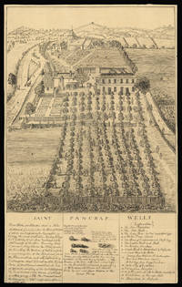
Saint Pancras Wells.: St Pancras
by [Anonymous]
- Used
- Condition
- Used
- Quantity Available
- 1
- Seller
-
London, United Kingdom
- Item Price
-
£950.00£15.00 shipping to USA
Show Details
Description:
[c.1750-1800].. 494 by 310mm (19.5 by 12.25 inches).. Drawing in ink with visible pencil guide lines. A drawing of Saint Pancras Wells. The area around what is now King's Cross was famous for its medicinal springs, and there were several wells in the area where Londoners could go to take the waters. The stones illustrated in the caption below the image were supposedly voided by people who had drunk the waters at St Pancras: they were also claimed as a cure for scrofula, leprosy and scurvy. The wells were named after the church, thought to be one of the oldest in England, which is visible in the background. The Wells grew into a destination for daytrippers as well as invalids: there were two pump rooms, tree-lined avenues for walking and a dining hall that could seat 200 people. A public house, the Adam and Eve, was built next to the church itself, visible in the print. This drawing, or one similar, was amongst those reproduced by the forger Peter Thompson. The British Museum holds two variants, but…
Read More Item Price
£950.00
£15.00
shipping to USA

Schonen d.13 Aprl. 1546. Gestorb. zu Prag d.24.Oct.1601.
by [ANONYMOUS]
- Used
- Condition
- Used
- Quantity Available
- 1
- Seller
-
London, United Kingdom
- Item Price
-
£160.00£15.00 shipping to USA
Show Details
Description:
[Weimar,: Friedrich Justin Bertuch,, c1810].. 120 by 84mm. (4.75 by 3.25 inches).. Prints,""Tycho Brahe Geb. zu Kundstorp in Tycho Brahe Stipple-engraved portrait. Published in one issue of the German geographical journal, 'Allgemeine geographische Ephemeriden', was the present portrait of renowned Danish astronomer, Tycho Brahe (1546-1601), who laid the foundation for the later invention of the telescope. The portrait is based on an engraving by Jacques de Gheyn II, who had drawn Brahe at the end of the sixteenth century. Most of Gheyn's details are retained, including the high collar and the chain of the Order of the Elephant, but an elaborate feathered beret has also been added. Brahe's famous false nose, which was rumoured to be made of gold, is also prominent. The portrait, which originally showed Brahe's whole upper body, is cut to just a bust, beneath which his name and dates of birth and death are given, in German. Interestingly, a larger version of the present portrait was published by…
Read More Item Price
£160.00
£15.00
shipping to USA
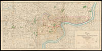
Plan of Shanghai & Environs Published Under Authority of the Municipal Council. 1933.: General Plan of Shanghai 1933
by [Anonymous]
- Used
- Hardcover
- Condition
- Used
- Binding
- Hardcover
- Quantity Available
- 1
- Seller
-
London, United Kingdom
- Item Price
-
£25,000.00£15.00 shipping to USA
Show Details
Description:
Shanghai,: Shanghai Municipal Council,, 27th October 1932.. 860 by 1744mm. (33.75 by 68.75 inches).. Coloured lithograph map, dissected and laid on linen, early ownership stamp of "John Pook & Co." in blank area, folding into original cloth portfolio, lettered in gilt 'General Map of Shanghai 1933' on spine. Acknowledgement is made of information obtained from the French Municipal Council, the Shanghai City Government, and the Whangpoo Conservancy Board. The map depicts Shanghai city in 1933, however, the date printed on the bottom right corner is 27th October 1932. The round shape of the Old city is still clearly visible as in the Plan of Shanghai printed in 1928, it is labelled the "Chinese City" Similarly, immediately to the north, east and west is the French Concession, and further to the north is the International Settlement. It is printed with a legend, which includes: villages and developed property; creek; motor road; path and roads; and important buildings. Compared with the Plan of…
Read More Item Price
£25,000.00
£15.00
shipping to USA
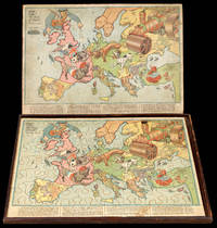
Hark! Hark! the Dogs do Bark.": The Dogs of War are loose in Europe" with note by Walter Emanuel.
by [ANONYMOUS]
- Used
- Condition
- Used
- Quantity Available
- 1
- Seller
-
London, United Kingdom
- Item Price
-
£2,500.00£15.00 shipping to USA
Show Details
Description:
London,: G.W. Bacon & Co,, 1914.. 530 by 705mm. (20.75 by 27.75 inches).. Chromolithographed map, laid on wood, cut into a jigsaw, housed in original box, small piece missing upper right. An humorous serio-comic map of Europe in jigsaw form, showing a satirical depiction of the beginning of the First World War. The principal combatants are portrayed in canine form: a British bulldog, French poodle, German dachshund and an Austro-Hungarian mongrel. The Royal Navy is controlled by John Bull in the costume of a Jack Tar. To the left, Russia is portrayed as a steamroller driven by the Tsar, who has already trapped the tail of the Austrian mongrel, and threatens to crush all before him. The mongrel is also being stung by a Serbian hornet and is leashed to the German dachshund, who is having his nose bitten by the British bulldog. Below the fighting dogs lies Italy as a soldier with gun in hand, deciding which side to join. To the right, Greece stares menacingly with dagger drawn at the Ottoman Empire,…
Read More Item Price
£2,500.00
£15.00
shipping to USA
![[Lambeth Suspension Bridge].](https://d3525k1ryd2155.cloudfront.net/h/926/909/1162909926.0.m.jpg)
[Lambeth Suspension Bridge].: Lambeth Suspension Bridge
by [Anonymous]
- Used
- Condition
- Used
- Quantity Available
- 1
- Seller
-
London, United Kingdom
- Item Price
-
£3,000.00£15.00 shipping to USA
Show Details
Description:
[c.1861].. 240 by 600mm (9.5 by 23.5 inches).. Watercolour on paper. The first modern bridge at Lambeth was a suspension bridge, designed by Peter W. Barlow. Sanctioned by an Act of Parliament in 1860, it opened as a toll bridge in 1862, but doubts about its safety, coupled with its awkwardly steep approaches deterring horse-drawn traffic, meant it soon became used almost solely as a pedestrian crossing. It ceased to be a toll bridge in 1879 when the Metropolitan Board of Works assumed responsibility for its upkeep it was by then severely corroded, and by 1910 it was closed to vehicular traffic.
Item Price
£3,000.00
£15.00
shipping to USA
![[A Fan depicting the Siege of Gibraltar]](https://d3525k1ryd2155.cloudfront.net/h/309/910/1162910309.0.m.jpg)
More Photos
[A Fan depicting the Siege of Gibraltar]: A rare fan of the siege of Gibraltar
by [Anonymous]
- Used
- Condition
- Used
- Quantity Available
- 1
- Seller
-
London, United Kingdom
- Item Price
-
£10,000.00£15.00 shipping to USA
Show Details
Description:
Spain,, [?c1780].. Folding paper fan with a fine large hand-coloured engraved view of the Siege of Gibraltar with Spanish ships and troops in the foreground, the verso with engraved key in Spanish decorated with weapons of war on either side, mounted on ivory sticks , the ivory sticks decorated in silver and gilt with a fort, ship and flag, the gaurdsticks carved and pierced and with silver and gilt depicting a ship and drums. The unsuccessful siege of Gibraltar began in 1779 and lasted until February 1783, when the siege was lifted. This fan, which it has been suggested belonged to the Earl of Minto, is not in the Schreiber Collection.
Item Price
£10,000.00
£15.00
shipping to USA
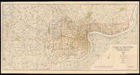
Plan of Shanghai 1928: Plan of Shanghai, 1928 Published under authority of the Municipal Council 1928.
by [Anonymous]
- Used
- Signed
- Condition
- Used
- Quantity Available
- 1
- Seller
-
London, United Kingdom
- Item Price
-
£20,000.00£15.00 shipping to USA
Show Details
Description:
London,: Standford's Geog.l Establishment, London,, 21st April 1928.. 880 by 1660mm. (34.75 by 65.25 inches).. A large coloured lithographed map showing the plan of Shanghai, made in 1928. Signed by Commissioner of public works, 44 (4 by 11) sheets mounted on linen. The map depicts Shanghai city in 1928, with the French Settlements and Shanghai International Settlements hand-coloured in outline in brown and pink. Two lines noted below the title: 1. The Pootung shore is taken from surveys by the Whangpoo Conservancy Board. 2. The French settlement is taken from surveys by the French Municipal Council. The famous Whangpoo (Huangpu) river in Shanghai is prominently shown from the midpoint of the bottom edge sinuating upwards to the top right corner, which divides the settlements to the left and Pootung (Pudong) to the right. Between the bank of the river and the French settlement, are the 'Chinese city' and a district labeled 'Nan Tao' (Nan Dao). The "Chinese city", is now called the "Old City", the…
Read More Item Price
£20,000.00
£15.00
shipping to USA

Didn’t find what you’re looking for?
Try adding this search to your want list. Millions of books are added to our site everyday and when we find one that matches your search, we’ll send you an email. Best of all, it’s free.
Add to Want List

Are you a frequent reader or book collector?
Join the Bibliophile's Club and save 10% on every purchase, every day — up to $20 savings per order!

Social Responsibility
Did you know that since 2004, Biblio has used its profits to build 16 public libraries in rural villages of South America?
