17th Century
We can help you find the 17th century books you are looking for. As the world's largest independent marketplace for new, used and rare books, you always get the best in service and value when you buy from Biblio.co.uk, and all of your purchases are backed by our return guarantee.
Top Sellers in 17th Century


17th Century Books & Ephemera


Operum omnium Iatro-Galenicorum, Operum omnium Iatro-Galenicorum,, & penetralibus erutorum tomus unicus... Opera & studio Ludovici Serrani
by LIDDEL, Duncan
Lyon: Antoine Chard, 1624. hardcover. very good. Rubricated title. Title woodcut. 473, 308 pages, index. 4to, later calf; worn, hinges cracked, repaired title no loss of text. Lyon: Antoine Chard, 1624. Internally very good(+).<br/> <br/> First combined edition of Ars Medica (1607) and De Febribus (1610), by the noted Scottish mathematician and physician. The two medical works, a general treatise on medicine and study on fevers, were held in high esteem in his day. Liddel, a professor then...
Read more about this item
Item Price
£647.60

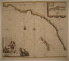
Isles Molucques
by DUVAL, Pierre
Paris: Pierre Duval, 1682. unbound. ANTIQUE. Miniature map. Uncolored engraving. Image measures 4" x 5", page measures 5 3/4" x 6 1/4".<br/> <br/> This charming miniature map shows the Maluku Islands, or the "Spice Islands". Extends from Philippines in this North to Timor in the South, and from Borneo at the western border to New Guinea in the east. The map is in very good condition. Original centerfold as issued. <br> <br> Pierre Duval (1618-1683)...
Read more about this item
Item Price
£141.66

POLITICS AND ADMINISTRATION OF TUDOR AND STUART ENGLAND, PARTS 1-3 : REPRODUCED FROM THE LANSDOWNE COLLECTION IN THE BRITISH LIBRARY IN LONDON
The Harvester Press. Good. 1977. Booklet. Booklet; very good in scratched and marked card covers. ; Combined reprint of the three guides issued with The Harvester Press 35mm roll-film collection, reproduced from the Lansdowne Collection in the British Library. ; 30 pages .
Item Price
£4.00

Alsatia Landgraviatus, cum Suntgoia et Brisgoia
by BLAEU, Willem
Amsterdam. unbound. Map. Copperplate engraving with hand coloring. Image measures 15.5 x 31". Sheet measures 22 x 33".<br/><br/> This map of the historic French region of Alsace focuses on the lower Rhine River. Oriented with north to the right, the map describes a fertile area of France that, due to the many tributaries of the river, has historically been well-known for its wine. Perhaps the lushness of the region can account for the map's, particularly risqué...
Read more about this item
Item Price
£890.45

Fezzae et Marocchi Regna Africae Celeberrima
by OGILBY, John
London: John Ogilby, 1670. unbound. Map. Engraving with hand coloring. Image measures 10 1/2" x 13 3/4"<br/> <br/> Gorgeous map of Northern Africa, part of Spain and the Strait of Gibraltar. Decorative elements include a camel around the title cartouche and schooners at sea. North is oriented to the right. On 17th century laid paper with a watermark. Published in 1670 in Ogilby's "Africa". Small damp-stains at edges, not affecting the image. Minor toning. Otherwise in...
Read more about this item
Item Price
£392.61

Printing in the Fifteenth Century
by Winship, George Parker
Volume is completely solid, binding undamaged in any way, all pages tight and bright, with perhaps a touch of age-darkening. Has some staining on endpapers. Spine appears faded, even though it has been protected by an untorn, unclipped dust jacket. Dust jacket shows some soiling, tanning of spine.A publication of the Rosenbach Fellowship in Bibliography.
Item Price
£24.28

EXETER IN THE CIVIL WAR
by Stoyle, Mark
Devon Archaeological Society. Very Good. 1995. Booklet. Devon Archaeology No.6. Booklet; very good in creased card covers. ; An illustrated introduction to the city during the English Civil War. ; 40 pages .
Item Price
£10.00

Steenwiick
by BLAEU, Johannes
Amsterdam. unbound. very good. Map. Engraving with original hand coloring. Image measures 14" x 18.25".<br/><br/> Beautifully detailed town plan of Steenwijk in northeastern Holland, circa 1649, shown in an unusual panoramic birds-eye view. Features the fortress and the town within it, and the surrounding pastoral landscape. Includes two coats of arms. Latin text on verso. Published around the time of the Spanish acknowledgment of the Dutch Republic in "Novum Ac Magnum...
Read more about this item
Item Price
£526.18

Doesburgh
by BLAEU, Johannes
Amsterdam. unbound. very good. Map. Engraving with original hand coloring. Image measures 16 5/8" x 20.5".<br/><br/> Beautifully colored town plan of Doesburg in northeastern Holland, shown in an unusual panoramic birds-eye view, circa 1649. Features the fortress walls and a few cottages in the surrounding landscape. Includes two coats of arms, both of which have been hand burnished with beautiful gold leaf. Scale also includes gold leaf. Latin text on verso. Published around the...
Read more about this item
Item Price
£404.75
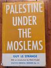
Palestine Under the Moslems:
by Le Strange, Guy
Dust jacket: Good; shows some fraying, wear and fading of spine. Volume itself: near fine, with a very little bumping of head and heel of spine.From the library of the distinguished medievalist Prof. K.M. Setton (1914-1995) of the Princeton Institute for Advanced Study, whose signature it bears.Prof. Le Strange (1854 - 1933) was the leading British Orientalist of his time who specialized in the historical geography of the premodern Middle East and eastern Islamic domains. This is the first...
Read more about this item
Item Price
£40.48

Indiarum Occidentalium Tractus Littorales cum Insulis Caribicis. / Pascaert van Westindien ende Caribise Eylanden
by DE WIT, Frederick
Paris: Frederick de Wit, 1680. unbound. Map. Copper plate engraving with original hand color. Image measures 19" x 22 1/4". c.1680<br/> <br/> This rare and beautiful sea chart of the West Indies is an unrecorded edition by Frederick de Wit. The chart covers Central America, West Indies, Florida and the Gulf of Mexico. Unlike the first state of this map, this variation details the west coast of Central America and the southern coastline of New England. The Chesapeake Bay region is...
Read more about this item
Item Price
£2,833.25

Amygdalus Nana
by MUNTING, Abraham
Leyden and Utrecht: Pieter Vander Aa, 1696. unbound. very good(+). Botanical. Copper plate engraving with hand coloring. Image measures 12.5" x 8.25".<br/> <br/> Abraham Munting (1626-1683) taught medicine and botany at the Academy of Groningem in the Netherlands. He had a particular interest in the uses of plants, especially medicinally. This engraving is from "Naauwkeurige Beschryving Der Aardgewassen". Scattered foxing to margins, small chips to right edge. Hinges on...
Read more about this item
Item Price
£161.90
![[Lemnos. Hellespont]](https://d3525k1ryd2155.cloudfront.net/h/829/517/943517829.0.b.jpg)
[Lemnos. Hellespont]
by SANDYS, George
London: George Sandys. unbound. Miniature map. Colored engraving. Sheet measures 10.25" x 7". London: Sandys, 1615<br/> <br/> This lovely circa 1615 map depicts the Hellespont or the Dardanelles, a narrow strait northwest of Turkey. Oriented with north at the bottom, the map covers the Gallipoli Peninsula or the Thracian Chersonese and part of the Asian section of northwest Turkey. Includes the island of Imbros or Gökçeada. The...
Read more about this item
Item Price
£214.52

Swarteslvys
by BLAEU, Johannes
Amsterdam. unbound. very good. Map. Engraving with original hand coloring. Image measures 16.25" x 20.75".<br/><br/> Exquisite town plan of Zwartsluis in northeastern Holland, shown in an unusual panoramic birds-eye view, circa 1649. Features the fortress and the town within it facing the ships in the outstretched waters. North is oriented toward the bottom of the page. Scale includes hand burnished gold leaf. Latin text on verso. Published around the time of the Spanish...
Read more about this item
Item Price
£283.32
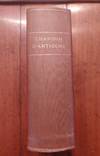
La Chanson d'Antioche
by Paris, Alexis Paulin, Richard le pèlerin, Graindor de Douay
Text is first edition, one of 500 copies on laid rag paper ("papier d'Hollande" - copy # not filled in), binding probably not contemporary, Very good condition, with a little foxing, particularly in first part of volume. Includes all eight of the chansons.The famous chanson de geste in 9000 lines, known in a version of a lost original composed about 1180 and attributed to Richard le Pèlerin, a pilgrim who was on the spot and began composition during the siege of Antioch, inspired by the events of...
Read more about this item
Item Price
£202.38

Carte Particuliere des Costes de l'Afrique qui comprend une Partie dela Guinée et Partie de Mina etc.
by MORTIER, Pierre
Amsterdam: Pierre Mortier, 1693. unbound. Map. Copper plate engraving with original hand coloring. Image measures 19.5 x 31".<br/> <br/> This beautiful chart of the coast of Africa extends from Palmares (close to modern day Conakry in Guinea) to Fort Nassau in Ghana including parts of the Gold Coast, Pepper Coast or Grain Coast and the Ivory Coast. The map covers the coastline of modern day Guinea, Sierra Leone, Liberia, Cote d'Ivoire and Ghana. The chart offers incredible coastal...
Read more about this item
Item Price
£283.32
![Reports And Cases Of Law: Argued And Adjudged In The Courts At Westminster, In The Times Of The Late Queen Elizabeth, And King James [ Four Parts Bound in One Volume]](https://d3525k1ryd2155.cloudfront.net/h/647/674/1516674647.0.b.jpg)
Reports And Cases Of Law: Argued And Adjudged In The Courts At Westminster, In The Times Of The Late Queen Elizabeth, And King James [ Four Parts Bound in One Volume]
by Leonard, William
London: Printed by Tho. Roycroft, For Nath. Ekins, 1658. Hardback, full calf. 29.5 x 19.5cm. Four parts bound together, dated 1658, 1659, 1663, and 1675. [xii], 336pp, [8]; [viii], 226pp, [4]; [xii], 279pp, [56]; [xii], 252pp, [12]. Each with their own title page and table. Spine relaid, label replaced, end-papers renewed. Binding slightly rubbed. Secure binding. Previous owners' details and stamp to free front end-paper and title page. Some contemporary marginal annotation. Some mainly marginal...
Read more about this item
Item Price
£300.00

Comitatus Zelandiae Novissima Delineatio
by VISSCHER, Nicolaes
Amsterdam: Nicolaas Visser, 1690. unbound. Map. Engraving with extended publisher margins, and no centerfold. Image measures 18 1/4 x 21 5/8", Sheet measures 20 7/8 x 24 3/4". Page number written in ink upper right margin.<br/><br/> Striking map of Zeeland, the westernmost province of the Netherlands. Showing the islands of Walcheren, Beveland, Schouwen and Tholen within the Scheldt estuary, and Flanders in the south. The map illustrates polders, topography, roads, town and...
Read more about this item
Item Price
£445.22

Carta Maritima dell' Isole di Corfu, Pachsu, et Antipachsu, e come entrar si possi in esse cossi da Tramontana come da Mezzogiorno
by LEVANTO, Francesco Maria
Genoa: Francesco Maria Levanto, 1664. unbound. very good(+). Sea chart. Uncolored engraving. Image measures 15.75" x 20.5".<br/><br/> This incredible 1664 map of Corfu, the second largest Greek Island in the Ionian Sea, was issued by Captain Francesco Maria Levanto. The maritime map or sea chart includes the islands of Corfu, Paxi and the western coast of Greece with north oriented towards the left. Numerous rhumb lines, coastal features, depth soundings, anchorages, shoals, and...
Read more about this item
Item Price
£2,428.50

Love and War in the Middle English Romances
by Gist, Margaret A
214 pages. Volume in Near Fine condition, no corner bumping, staining, etc. All pages intact, tight, bright and clean.Prof. Gist's landmark study analyzing the difference between the history, economic, political and social conditions and the literary, romantic and idealized versions of them prevalent in two key areas of Medieval English life. The differences highlight the Weltanschauung of Medieval England and help to understand what was convention, what was reality and what was contemporary...
Read more about this item
Item Price
£28.33

Tartaria Sive Magni Chami Imperium
by BUCELIN, Gabriel
Augsburg: Johann Praetorius, 1658. unbound. very good. Miniature map. Uncolored engraving. Image measures 2.5" x 4.25".<br/> <br/> Rare early map of China and surround with beautiful geographic details. The Great Wall of China is depicted. Published in the world atlas section of "Historiae universalis auctarium". Latin text on back, headed by "Andaluzia". Page marked "XIV". Minor stain on left half, overall wear. Gabriel Bucelin was a Swiss...
Read more about this item
Item Price
£182.14
![La Vie de Messire Gaspar de Colligny Seigneur de Chastillon, Admiral de France. A Laquelle Sont Adiouste ses Memoires sur ce qui se passa au Siege de S. Quentin [with] Memoires de Gaspar de Colligny....Ou sont sommai sommairement contenues Les Choses Etc.](https://d3525k1ryd2155.cloudfront.net/h/640/864/1470864640.0.b.jpg)
La Vie de Messire Gaspar de Colligny Seigneur de Chastillon, Admiral de France. A Laquelle Sont Adiouste ses Memoires sur ce qui se passa au Siege de S. Quentin [with] Memoires de Gaspar de Colligny....Ou sont sommai sommairement contenues Les Choses Etc.
by Serres, Jean De; Hotman, Francois (trans.)
Leiden: Bonaventure & Abraham Elzevir, 1643. Hardback, contemporary full velllum with hand written spine labelling. 13 x 8cm. [8], 143pp, [1], 88pp. Two parts bound in a single volume. Later bookplate on free front end-paper. Inscriptions to the front pastedown & title page. Ink smudge to title page. Contents clean. Slight wear only to binding. A rather nice copy. . Hard Cover. Good.
Item Price
£260.00
Nieuwe Pascaert vande Kust van Maroca en Zanhaga beginnend van C. Cantin tot C. Bajador, waer in ook te sien is 't I. Lancerota en 't I. Forteventura, met al syn diepte en drooghte, dus ver Naeukeurig op gestelt van bekende Stuerlieden, syn te bekomen
by VAN KEULEN, Johannes
Amsterdam, 1681. unbound. very good(+). Sea chart. Copper plate engraving with modern hand coloring. Image measures 20" x 22 7/8".<br/><br/> Beautifully rendered sea chart with north oriented to the left. Shows the southwestern coast of Morocco and part of Western Saraha, from Cape Cantin to Cape Bajador, including the eastern most Canary Islands. An inset shows ports on the Island of Lanzerota. Features rhumb lines, a compass rose, depths, nicely detailed banks and a decorative...
Read more about this item
Item Price
£607.12
A RELATION OF A CONFERENCE, HELD ABOUT RELIGION, AT LONDON, THE THIRD OF APRIL, 1676 BY EDW. STILLINGFLEET AND GILBERT BURNET, WITH SOME GENTLEMEN OF THE CHURCH OF ROME.
by Stillingfleet (Edward)
Printed and Sold By Moses Pitt. Good with no dust jacket. 1676. Hardcover. Catholicism; Ex-Library; Thick 12mo 7" - 7½"; [20], 57pp, [1], 193pp, [3] pages; A relation [by Gilbert Burnet] of a conference... By Edward Stillingfleet A relation [by Gilbert Burnet] of a conference held about religion, at London, ... By E. S. ... And G. Burnet, with some gentlemen of the Church of Rome [E. Coleman and others]. Bound in contemporary, but probably a little later, leather. Cracked and split...
Read more about this item
Item Price
£237.95
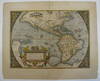
Americae Sive Novi Orbis, Nova Descriptio
by ORTELIUS, Abraham
Abraham Ortelius, 1612. unbound. very good(+). Map. Engraving with hand coloring. Image measures 14" x 19.25".<br/><br/> This stunning 1612 map by Abraham Ortelius depicts the Western Hemisphere. At the time it was issued, the coastal areas of the New World had been fairly well explored, and Europeans were just beginning settlement and colonization. It is notable for depicting Spanish and Portuguese colonies in high detail, for these powers were notoriously protective of their...
Read more about this item
Item Price
£5,261.75


