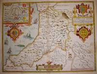
Description:
London, c. 1764. Copper engraving, 41.5 x 50.5 cm, original outline hand-colour with recent additions to cartouche and vignette of Chester Cathedral, blank verso; from the ‘Royal English Atlas’. Shirley, Atlases in the British Library, T-Bow 4a. Map
Search Results: British Counties from Bryars and Bryars
You searched for:
- Subject: British Counties from Bryars and Bryars
Results 1 - 20 of 161
![An Accurate Map of the County Palatine of Chester [...]](https://d3525k1ryd2155.cloudfront.net/h/600/287/267287600.0.m.jpg)
An Accurate Map of the County Palatine of Chester [...]
by Bowen, Emanuel & Kitchin, Thomas:
- Used
- Condition
- Used
- Quantity Available
- 1
- Seller
-
London, United Kingdom
- Item Price
-
£300.00£5.95 shipping to USA
Show Details
Item Price
£300.00
£5.95
shipping to USA
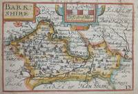
Barkshire
by ENGLAND, BERKSHIRE: Keere, Pieter van den:
- Used
- Condition
- Used
- Quantity Available
- 1
- Seller
-
London, United Kingdom
- Item Price
-
£90.00£5.95 shipping to USA
Show Details
Description:
London, c. 1646. Copper engraving, 8.7 x 12.7 cms, recent hand-colour, English text on verso. From the so-called ‘minature Speed’ which used maps by van den Keere to illustrate a pocket edition of Speed’s text, and which Humble appears to have printed to coincide with editions of the larger atlas. Map
Item Price
£90.00
£5.95
shipping to USA

Bedforshire
by ENGLAND, BEDFORDSHIRE: Bowen & Owen:
- Used
- Condition
- Used
- Quantity Available
- 1
- Seller
-
London, United Kingdom
- Item Price
-
£65.00£5.95 shipping to USA
Show Details
Description:
London, c. 1720. Copper engraving, 18 x 12 cms, recent hand-colour, b/w strip-maps on verso. Map
Item Price
£65.00
£5.95
shipping to USA
Bercheria vernacule Barkshire.
by Blaeu:
- Used
- first
- Condition
- Used
- Quantity Available
- 1
- Seller
-
London, United Kingdom
- Item Price
-
£600.00£5.95 shipping to USA
Show Details
Description:
Amsterdam, 1645. Copper engraving, 38.5 x 50 cms, original hand-colour, French text on verso. Blaeu and the rival Golden Age Dutch cartographic publishing house of Janssonius raced to bring out atlases of the British Isles in the 1630s and early 1640s, to add to their expanding world atlases. The work of the two firms represents Dutch map-making of the highest quality at a time when the Low Countries were at the forefront of the international market. Both worked from Elizabethan and Jacobean surveys by Saxton, Speed and others, and based the accompanying text on Camden's Britannia. Distinctive features of English county cartography (such as the enclosures) were retained, as often were the coats of arms of distinguished local historical figures, and the decorative elements give a flavour of the region. Blaeu issued the first editions of his British atlas, with Latin and French text, in 1645 and Dutch text the following year. It was never printed in English. The Blaeu Atlas was eventually extended…
Read More Item Price
£600.00
£5.95
shipping to USA
Berkshire
by ENGLAND, BEDFORDSHIRE: Bowen & Owen:
- Used
- Condition
- Used
- Quantity Available
- 1
- Seller
-
London, United Kingdom
- Item Price
-
£80.00£5.95 shipping to USA
Show Details
Description:
London, c. 1720. Copper engraving, 18 x 12 cms, recent hand-colour, b/w strip-maps on verso. Map
Item Price
£80.00
£5.95
shipping to USA
Berkshire
by ENGLAND, BERKSHIRE: Bowen & Owen:
- Used
- Condition
- Used
- Quantity Available
- 1
- Seller
-
London, United Kingdom
- Item Price
-
£80.00£5.95 shipping to USA
Show Details
Description:
London, c. 1720. Copper engraving, 18 x 12 cms, recent hand-colour, b/w strip-maps on verso. Map
Item Price
£80.00
£5.95
shipping to USA

Breknokshire
by WALES, BRECKNOCKSHIRE: Seller, John:
- Used
- Condition
- Used
- Quantity Available
- 1
- Seller
-
London, United Kingdom
- Item Price
-
£50.00£5.95 shipping to USA
Show Details
Description:
London, c. 1695. Copper engraving, 12.2 x 15 cms, original hand-colour, blank verso. Map
Item Price
£50.00
£5.95
shipping to USA
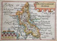
Buckinghamshire
by Walker, John & Charles:
- Used
- Condition
- Used
- Quantity Available
- 1
- Seller
-
London, United Kingdom
- Item Price
-
£100.00£5.95 shipping to USA
Show Details
Description:
London: Longman, Rees, Orme, Brown & Co., c. 1860. Lithograph, 32.5 x 40 cms, original hand-colour, blank verso; prepared for William Colling Hobson’s “Fox-Hunting Atlas”, overprinted with the names of the hunts and the places of the meeting of foxhounds. Map
Item Price
£100.00
£5.95
shipping to USA
Buckinghamshire
by ENGLAND, BUCKINGHAMSHIRE: Keere, Pieter van den:
- Used
- Condition
- Used
- Quantity Available
- 1
- Seller
-
London, United Kingdom
- Item Price
-
£100.00£5.95 shipping to USA
Show Details
Description:
London, c. 1646. Copper engraving, 8.7 x 12 cms, recent hand-colour, English text on verso. From the so-called ‘minature Speed’ which used maps by van den Keere to illustrate a pocket edition of Speed’s text, and which Humble generally printed to coincide with editions of the larger atlas. Map
Item Price
£100.00
£5.95
shipping to USA
Cambridgeshire
by Morden, Robert:
- Used
- Condition
- Used
- Quantity Available
- 1
- Seller
-
London, United Kingdom
- Item Price
-
£200.00£5.95 shipping to USA
Show Details
Description:
London,, c. 1695. Copper engraving, 42.5 x 36 cm, modern hand-colour, a couple of closed marginal nicks and tears, blank verso. Robert Morden's maps were engraved to illustrate Gibson's edition of William Camden's Britannia, first published in 1695 and reprinted in various 18th century editions. Camden was an Elizabethan historian who wrote a county by county description of England. He continued to revise and expand his work, which set new standards for historical research, and an illustrated edition with maps engraved by William Kip and William Hole was first published in 1607. By the late 17th century it had become scarce and expensive and there were calls for a new edition. Bishop and antiquary Edmund Gibson completely revised the text and commissioned a new series of maps from Morden, which are known for their clarity and elegance. Morden is is thought to have come from the north of England, possibly Yorkshire (see Worms and Baynton-Williams, British Map Engravers, 2011). Established…
Read More Item Price
£200.00
£5.95
shipping to USA
Cambridgeshire
by ENGLAND, CAMBRIDGESHIRE: Kitchin, Thomas:
- Used
- Condition
- Used
- Quantity Available
- 1
- Seller
-
London, United Kingdom
- Item Price
-
£65.00£5.95 shipping to USA
Show Details
Description:
London, c.1750. Copper engraving, 17 x 23 cms, recent hand colour, slight spotting, blank verso; published in the London Magazine. Map
Item Price
£65.00
£5.95
shipping to USA
Cambridgeshire
by ENGLAND, CAMBRIDGESHIRE: Kitchin, Thomas:
- Used
- Condition
- Used
- Quantity Available
- 1
- Seller
-
London, United Kingdom
- Item Price
-
£65.00£5.95 shipping to USA
Show Details
Description:
London, c. 1780. Copper engraving, 23 x 18 cms, recent hand colour, printed on paper stock with a blue tint, blank verso. This map was first issued in The London Magazine, which between 1747 and 1754 published a complete set of English county maps by Thomas Kitchin. The maps were subsequently published as a pocket atlas and reissued as a set by Alexander Hogg in “Boswell's Antiquities of England & Wales”.
Map
Item Price
£65.00
£5.95
shipping to USA
Cantium vernacule Kent
by Blaeu, Joannes:
- Used
- first
- Condition
- Used
- Quantity Available
- 1
- Seller
-
London, United Kingdom
- Item Price
-
£650.00£5.95 shipping to USA
Show Details
Description:
Amsterdam, 1646. Copper engraving, 38.5 x 53 cm, original hand-colour, small stain in lower margin, well away from printed area; German text on verso. Blaeu and the rival Golden Age Dutch cartographic publishing house of Janssonius raced to bring out atlases of the British Isles in the 1630s and early 1640s, to add to their expanding world atlases. The work of the two firms represents Dutch map-making of the highest quality at a time when the Low Countries were at the forefront of the international market. Both worked from Elizabethan and Jacobean surveys by Saxton, Speed and others, and based the accompanying text on Camden's Britannia. Distinctive features of English county cartography (such as the enclosures) were retained, as often were the coats of arms of distinguished local historical figures, and the decorative elements give a flavour of the region. In this case the cannon below the cartouche emphasise the strategic importance of Kent, which was strongly fortified along the coast and…
Read More Item Price
£650.00
£5.95
shipping to USA
Cardigan Shyre described with the due forme of the Shiretown as it was surveyed by J.S. Anno 1610.
by Speed, John:
- Used
- first
- Condition
- Used
- Quantity Available
- 1
- Seller
-
London, United Kingdom
- Item Price
-
£450.00£5.95 shipping to USA
Show Details
Description:
London: Basset & Chiswell, 1676. Copper engraving, 39 x 51.5 cms, recent hand-colour, inset of Cardigan, very minor staining on the right-hand side of the map, English text on verso. John Speed (1552-1629) is unquestionably the most significant English map-maker of the seventeenth-century. A brief note, from Granger's Bibliographical History of England (1779) contains most of the information we have about Speed's life: "John Speed, who was bred a Tailor, was by the generosity of Sir Fulk Grevil, his patron, set free from a manual employment and enabled to pursue his studies, to which he was strongly inclined by the bent of his genius. The fruits of them were his Theatre of Great Britain, containing an entire set of maps of the counties drawn by himself, his History of Great Britain, richly adorned with seals, coins & medals, from the Cotton collection; and his Genealogies of Scripture, first bound up with the Bible, in 1611 which was the first edition of the present English…
Read More Item Price
£450.00
£5.95
shipping to USA

Cardiganshire
by WALES, CARDIGANSHIRE: Seller, John:
- Used
- Condition
- Used
- Quantity Available
- 1
- Seller
-
London, United Kingdom
- Item Price
-
£65.00£5.95 shipping to USA
Show Details
Description:
London, c. 1695. Copper engraving, 12.2 x 15 cms, original hand-colour, blank verso. Map
Item Price
£65.00
£5.95
shipping to USA
Cardigan Comitatus pars olim Dimetarum
by Saxton-Kip:
- Used
- Condition
- Used
- Quantity Available
- 1
- Seller
-
London, United Kingdom
- Item Price
-
£200.00£5.95 shipping to USA
Show Details
Description:
London, 1637. Copper engraving, 26.5 x 3.5 cm, engraved by William Kip after Christopher Saxton, modern hand-colour, light toning where previously mounted and framed and with an old paper repair in the lower margin, blank verso. Cardiganshire, published in the second edition of Philemon Holland’s translation of Camden’s Britannia into English, the third printing overall to be illustrated by the series of maps engraved by Kip and Hole. Skelton, County Atlases, 23. Map
Item Price
£200.00
£5.95
shipping to USA

Caricta Borealis vulgo the northpart of Carrick
by SCOTLAND, AYRSHIRE: Blaeu:
- Used
- Condition
- Used
- Quantity Available
- 1
- Seller
-
London, United Kingdom
- Item Price
-
£250.00£5.95 shipping to USA
Show Details
Description:
Amsterdam, 1654. Copper engraving, 42 x 52 cms, with original hand-colour, Dutch text to verso. Map
Item Price
£250.00
£5.95
shipping to USA
Ceretica sive Cardiganensis Comitatus; Anglis Cardigan Shire.
by Blaeu, Joannes:
- Used
- first
- Condition
- Used
- Quantity Available
- 1
- Seller
-
London, United Kingdom
- Item Price
-
£250.00£5.95 shipping to USA
Show Details
Description:
Amsterdam, 1662. Copper engraving, 38.5 x 50.5 cm, original hand-colour, marginal toning where previously mounted, Spanish text on verso. Monmouthshire and the Severn Estuary from “the rarest edition of Blaeu’s Large Atlases”: only ten of the proposed eleven volumes were completed and issued in a limited quantity between 1658 and the the 1672 fire, which brought work on the final volume to a halt. Blaeu and the rival Golden Age Dutch cartographic publishing house of Janssonius raced to bring out atlases of the British Isles in the 1630s and early 1640s, to add to their expanding world atlases. The work of the two firms represents Dutch map-making of the highest quality at a time when the Low Countries were at the forefront of the international market. Both worked from Elizabethan and Jacobean surveys by Saxton, Speed and others, and based the accompanying text on Camden's Britannia. Distinctive features of English county cartography (such as the enclosures) were retained, as often…
Read More Item Price
£250.00
£5.95
shipping to USA

Cestria Comitatus Palatinatus. The Countye Palatine of Chester.
by Janssonius, Joannes:
- Used
- first
- Condition
- Used
- Quantity Available
- 1
- Seller
-
London, United Kingdom
- Item Price
-
£650.00£5.95 shipping to USA
Show Details
Description:
Amsterdam, 1649. Copper engraving, 38.5 x 50 cms, recent hand-colour, French text on verso. Joannes Janssonius II (1588-1664) married into the Hondius family and, with Henricus Hondius, worked on a revised edition of the Mercator-Hondius atlas (which was known as the Atlas Novus from 1638 onwards). The Hondius-Janssonius map publishing business traced its roots back to Gerardus Mercator. Mercator coined the term 'atlas' (after the wise, mythical, Mauritanian king rather than the weary titan) and the original Mercator Atlas (published in parts between 1585 and 1595) was an enormous advance in scientific terms: like Abraham Ortelius, Mercator edited his maps from the best available sources, but he advanced a step further and mapped the world on a standard projection. However, the Atlas was not an immediate commercial success; the copper printing plates were purchased by Jodocus Hondius c. 1604, and a large number of maps were added for his first edition of 1606, which still traded on…
Read More Item Price
£650.00
£5.95
shipping to USA
Cheshire
by ENGLAND, CHESHIRE: Walker, John & Charles:
- Used
- Condition
- Used
- Quantity Available
- 1
- Seller
-
London, United Kingdom
- Item Price
-
£100.00£5.95 shipping to USA
Show Details
Description:
London: Longman, Rees, Orme, Brown & Co., c. 1860. Lithograph, 32.5 x 39.5 cms, original hand-colour, blank verso; prepared for William Colling Hobson’s “Fox-Hunting Atlas”, overprinted with the names of the hunts and the places of the meeting of foxhounds. Map
Item Price
£100.00
£5.95
shipping to USA

Didn’t find what you’re looking for?
Try adding this search to your want list. Millions of books are added to our site everyday and when we find one that matches your search, we’ll send you an email. Best of all, it’s free.
Add to Want List

Are you a frequent reader or book collector?
Join the Bibliophile's Club and save 10% on every purchase, every day — up to $20 savings per order!

Social Responsibility
Did you know that since 2004, Biblio has used its profits to build 16 public libraries in rural villages of South America?
