Description:
Bonne, Rigobert : Carte De L'Empire de Russie en Europe et en Asie. Paris, ca.1780. Copper engraved map with outline hand colouring. Central title and six scales. Plate number 24. Clean and bright on heavy paper. An attractive map showing northern hemisphere lands of Europe and Russian towards the North Pole. A fairly detailed depiction of this area. From "Atlas de Toutes les Parties Connues du Globe Terrestre...". Size approx 21x32cm (8.25x12.5 inches). Very good condition.
Search Results: Europe from Roz Hulse
You searched for:
- Subject: Europe from Roz Hulse
Results 1 - 12 of 12

More Photos
Carte De L'Empire de Russie en Europe et en Asie, Rigobert Bonne, ca.1780
by Rigobert Bonne
- Used
- Condition
- Used
- Edition
- Copper engraved map with outline hand colouring.
- Quantity Available
- 1
- Seller
-
Plymouth, Devon, United Kingdom
- Item Price
-
£30.00£35.00 shipping to USA
Show Details
Item Price
£30.00
£35.00
shipping to USA

France: Original 19th Century Map
by John Tallis and Rapkin
- Used
- Condition
- Used - Very Good-
- Quantity Available
- 1
- Seller
-
Plymouth, Devon, United Kingdom
- Item Price
-
£60.00£35.00 shipping to USA
Show Details
Description:
Tallis, John: France. London. ca.1851. From the Montgomery Martin Illustrated Atlas. Map engraved by Rapkin. Size approx 360 x 260mm. Original steel engraved map with original outline hand colouring. 6 vignette views including Calais Harbour, Garden of the Palais Royal, The Bridge of Toulouse, Palace of Fontainebleau. Decorative border. Single page unfolded map in excellent, clean condition. Associated text page of the Montgomery Martin Atlas included. A Good Tallis Map.
Item Price
£60.00
£35.00
shipping to USA

Italy from the Best Authorities, Russell, ca.1800
by Russell
- Used
- Condition
- Used
- Quantity Available
- 1
- Seller
-
Plymouth, Devon, United Kingdom
- Item Price
-
£20.00£35.00 shipping to USA
Show Details
Description:
Russell, J. : Italy from the Best Authorities. Nd but ca.1800. From "A New Geographical, Historical and Commercial Grammar and Present State of Several Kingdoms of the World". Copper engraving. Size approx 200 x 230mm. Two neat folds. Some age colouring to edges, otherwise very clean and bright. Includes Sicily and Sardinia. Scale with British miles and Italian miles.
Item Price
£20.00
£35.00
shipping to USA
![La Gaule [France], Monin, ca.1844](https://d3525k1ryd2155.cloudfront.net/h/194/067/50067194.0.m.jpg)
La Gaule [France], Monin, ca.1844
by Charles Monin
- Used
- Condition
- Used
- Quantity Available
- 1
- Seller
-
Plymouth, Devon, United Kingdom
- Item Price
-
£30.00£35.00 shipping to USA
Show Details
Description:
Monin, Charles : La Gaule Divisee en dix sept provinces. ca.1844. Paris. Size approx 230mm x 300mm. Hand coloured map with decorative border and scales. Bright and clean.
Item Price
£30.00
£35.00
shipping to USA

Map of Turkey in Europe and Hungary, Russell, ca 1800
by Russell
- Used
- Condition
- Used
- Quantity Available
- 1
- Seller
-
Plymouth, Devon, United Kingdom
- Item Price
-
£20.00£35.00 shipping to USA
Show Details
Description:
Russell, J. : Turkey in Europe and Hungary. Nd but ca.1800. From "A New Geographical, Historical and Commercial Grammar and Present State of Several Kingdoms of the World." Copper engraving. Size approx 200 x 230mm. Two neat folds. Some age colouring to edges, otherwise very clean and bright. Includes an scale in Hungarian miles and British Statute miles. Shows the region from the Black Sea to the Mediterranean and the Gulf of Venice and Moldavia, Greece, Romania and Hungary to the Bosphorus with Constantinople [Istanbul].
Item Price
£20.00
£35.00
shipping to USA

Northern Italy, Tallis, ca.1851: Original Antique Map.
by John Tallis & Rapkin
- Used
- Condition
- Used
- Edition
- 1st Edition
- Quantity Available
- 1
- Seller
-
Plymouth, Devon, United Kingdom
- Item Price
-
£50.00£35.00 shipping to USA
Show Details
Description:
Tallis, John: Northern Italy, London. [ca.1851]. From the Montgomery Martin Illustrated Atlas. Map engraved by Rapkin. Size approx 360 x 260mm. Original steel engraved map with original outline hand colouring. 4 vignette views including The Grand Canal Venice and St Peters Rome, Decorative border. Single page unfolded map in excellent, clean condition. Associated text page of the Montgomery Martin Atlas included. A Good Tallis Map.
Item Price
£50.00
£35.00
shipping to USA

Portions of the Russian Empire in Eastern and Western Asia, Fullarton, ca.1860
by A. Fullarton
- Used
- Condition
- Used
- Quantity Available
- 1
- Seller
-
Plymouth, Devon, United Kingdom
- Item Price
-
£41.00£35.00 shipping to USA
Show Details
Description:
A. Fullarton & Co. London: Portions of the Russian Empire in Eastern and Western Asia, ca.1860 from the Royal Illustrated Atlas of Modern Geography shows the land surrounding the Aral Sea and the Kamtchatka Peninsula. An original hand-coloured steel engraving with 7 vignettes including Kirghiz Hunting with the Falcon, Petropaulovs and a Winter Hut. Page size approx 470 x 310mm. Small tears to bottom margin not affecting images.
Item Price
£41.00
£35.00
shipping to USA
![Russia in Asia [Siberia], Tallis, ca.1851](https://d3525k1ryd2155.cloudfront.net/h/134/067/50067134.0.m.jpg)
Russia in Asia [Siberia], Tallis, ca.1851
by John Tallis & Rapkin
- Used
- Condition
- Used
- Quantity Available
- 1
- Seller
-
Plymouth, Devon, United Kingdom
- Item Price
-
£41.00£35.00 shipping to USA
Show Details
Description:
Tallis, John: Russia in Asia [Siberia], London. [ca.1851]. From the Montgomery Martin Illustrated Atlas. Map engraved by Rapkin. Size approx 360 x 260mm. Original steel engraved map with original outline hand colouring. 4 vignette views include Kamtchatkan Dogs, Troitsk,and Skorskarskoi Pagost. Decorative Border. Good condition with one fox mark within decorative border. Associated text page of the Montgomery Martin Atlas included.
Item Price
£41.00
£35.00
shipping to USA

Spain and Portugal from the Best Authorities, Russell, ca.1800
by Russell
- Used
- Condition
- Used
- Quantity Available
- 1
- Seller
-
Plymouth, Devon, United Kingdom
- Item Price
-
£20.00£35.00 shipping to USA
Show Details
Description:
Russell, J. : Spain and Portugal from the Best Authorities. Nd but ca.1800. From "A New Geographical, Historical and Commercial Grammar and Present State of Several Kingdoms of the World." Copper engraving. Size approx 200 x 230mm. Two neat folds. Some age colouring to edges, otherwise very clean and bright. Includes a scale in British miles and Spanish miles. Includes the Iberian Peninsular and the Balearic Islands of Majorca and Yvica [Ibiza].
Item Price
£20.00
£35.00
shipping to USA

Sweden and Norway, Wilkinson, 1826
by Robert Wilkinson
- Used
- good
- Condition
- Used - Good
- Quantity Available
- 1
- Seller
-
Plymouth, Devon, United Kingdom
- Item Price
-
£60.00£35.00 shipping to USA
Show Details
Description:
Wilkinson, Robert : Map of Sweden and Norway with their Dependancies. London, January 3, 1826. Also shows Iceland and the Faroe Islands as insets. Centre folding, fold split about 1cm into engraved area, small unobtrusive tear without any loss into blind margin, not affecting engraved area. Original hand colouring. Good margins. Map size approx 510mm x 610mm. Good condition and highly suitable for framing.
Item Price
£60.00
£35.00
shipping to USA
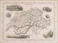
Switzerland,: Original 19th Century Map
by John Tallis and Rapkin
- Used
- Condition
- Used
- Edition
- 1st edition
- Quantity Available
- 1
- Seller
-
Plymouth, Devon, United Kingdom
- Item Price
-
£60.00£35.00 shipping to USA
Show Details
Description:
Tallis, John: Switzerland, London. [ca.1851]. From the Montgomery Martin Illustrated Atlas. Map engraved by Rapkin. Size approx 360 x 260mm. Original steel engraved map with original outline hand colouring. 6 vignette views including Bern, Chamois Hunters and William Tell shooting at the apple. Decorative border. Single page unfolded map in excellent, clean condition. Associated text page of the Montgomery Martin Atlas included.
Item Price
£60.00
£35.00
shipping to USA

Switzerland From the Best Authorities, Russell, ca 1800
by Russell
- Used
- Condition
- Used
- Quantity Available
- 1
- Seller
-
Plymouth, Devon, United Kingdom
- Item Price
-
£20.00£35.00 shipping to USA
Show Details
Description:
Russell, J. : Switzerland with its Subjects and Allies From the Best Authorities. Nd but ca.1800. From "A New Geographical, Historical and Commercial Grammar and Present State of Several Kingdoms of the World." Copper engraving. Size approx 200 x 230mm. Two neat folds. Some age colouring to edges, otherwise very clean and bright. Scale with British and German miles.
Item Price
£20.00
£35.00
shipping to USA

Didn’t find what you’re looking for?
Try adding this search to your want list. Millions of books are added to our site everyday and when we find one that matches your search, we’ll send you an email. Best of all, it’s free.
Add to Want List

Are you a frequent reader or book collector?
Join the Bibliophile's Club and save 10% on every purchase, every day — up to $20 savings per order!

Social Responsibility
Did you know that since 2004, Biblio has used its profits to build 16 public libraries in rural villages of South America?
