Description:
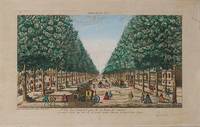
1750. Paris, Mondhare, [c.1750-1780]. Original hand-coloured copper engraved vue d'optique. Plate Size: 38.7 cm x 23.2 cm. Sheet Size: 44.7 cm x 28. 6 cm Original print. In very good, actually remarkable, condition. Clean and crisp and radiant impression, with only the faintest trace of browning. Some very minor traces of light staining to outer margin corner. A wonderful vue d'optique from 18th Century France. A beautiful, original hand-coloured copperplate engraving that shows a view the Porte Saint-Antoine which was one of the gates of Paris. The Porte of Sainte Antoine was located, and protected, by the Bastille. This engraving captures a more peaceable atmosphere of Parisian life around that notorious landmark: finely-dressed people and family groups are shown out strolling along the tree-lined broad boulevard and, off to the side, along the more sheltered promenade. It is a busy scene: In the foreground, under the shade of a tree a religious beggar seeks alms; nearby an unbusy street…
Read More Search Results: Graphics and Art from Inanna Rare Books Ltd.
You searched for:
- Subject: Graphics and Art from Inanna Rare Books Ltd.
Results 1 - 20 of 319
More Photos
1er Vue des Boulvard pris de la Porte St Antoine on averty le Public que cette Vuë est graveé pour estre vuë au naturet dans l'Optique.
by Paris - Mondhare, Louis-Joseph. (1734 - 1799)
- Used
- Condition
- Used
- Quantity Available
- 1
- Seller
-
Skibbereen, Ireland
- Item Price
-
£216.82£33.82 shipping to USA
Show Details
Item Price
£216.82
£33.82
shipping to USA

More Photos
[A New and Correct Chart of Cork Harbour (This is the rare 18th century Map of Cork Harbour which also shows Haulbowline Island, which is the original location of "The Royal Cork Yacht Club", later "The Water Club of the Harbour of Cork", the Map shows also the Old Head of Kinsale, Crosshaven Harbour, Haulbowline Island, Curraghbinny, Spike Island, Ringaskiddy etc.)] - Correct Title of the Map: "A New and Correct Chart of the Harbour of Corke by the Revd. J. Lindsay, Late of His Majesty's Ship Fougueux". There is an inset Map showing "A Continuation of Corke Harbour from a smaller Scale". The scale of this reads "A Scale of three English". Below the chart is a coastal profile entitled "A View of the Land from the Old Head of Kinsale to Hawks Rock, the Old Head W b S 7 Miles. Cork Harbour mark'd *. "
by Lindsay, The Rev. John
- Used
- Condition
- Used
- Quantity Available
- 1
- Seller
-
Skibbereen, Ireland
- Item Price
-
£2,428.44£33.82 shipping to USA
Show Details
Description:
1759. London, Sold by W. & I. Mount, T. & T. Page on Tower Hill, [c. 1759]. Original, hand-coloured copper engraving on extra thick paper / Better paper - edition [differing from all other versions of this map we ever handled, this is only the second version of this high-quality version of this Map we encountered], possibly an admiralty issue since it was dedicated to the Office of the Lord High Admiral of Great Britain. Beautifully mounted and framed. Size of the actual map: c. 62 cm wide x 52 cm high. Spectacular, unusually excellent condition of this rare, hand-coloured seachart of Cork Harbour with the Old Head and clear geography of Little Island, Poor Head, Ringaskiddy, Cork's Natural Harbour, Crosshaven, Haulbowline, Spike Island, Cloyne, etc. / Price includes worldwide free shipping per UPS Courier ! The inset Map "A Continuation of Corke Harbour from a smaller Scale" shows the region in greater detail. This inset Map even shows details of Cork City with Ballintemple and its Spring Garden,…
Read More Item Price
£2,428.44
£33.82
shipping to USA

Abbey of Saint John in Kilkenny.
by [Luckombe, Philip]
- Used
- Condition
- Used
- Quantity Available
- 1
- Seller
-
Skibbereen, Ireland
- Item Price
-
£125.76£33.82 shipping to USA
Show Details
Description:
2023. Skibbereen, Inanna Rare Books & Art Publishing House, 2023. Luxury Fine Art Giclée Reprint of the original Engraving which was printed in London by publisher Philip Luckombe in the year 1788. Image Size: 21,1 cm wide x 13,8 cm high. Sheet Size: 27,3 cm wide x 19,8 cm high. Excellent condition. © Copyright by Inanna Rare Books Ltd. [Price includes 23% VAT (27,11 ) / Net: (117,89 )] The Abbey of Saint John is also called St John's Priory and is a medieval Augustinian priory and National Monument located in Kilkenny. The Lady Chapel of the priory is now used as a parish church of the Church of Ireland. (Wikipedia)
Item Price
£125.76
£33.82
shipping to USA

More Photos
Aberdeen - With Vignettes of North Church, King Street, Old Don Bridge, Castle Street, Naval Vessel, and City Panorama.
by Britain - Tallis, John / Rapkin, John. (1817 - 1876)
- Used
- Condition
- Used
- Quantity Available
- 1
- Seller
-
Skibbereen, Ireland
- Item Price
-
£325.24£33.82 shipping to USA
Show Details
Description:
1851. London & New York, John Tallis & Company, 1851. Original steel engraving / Vintage map. Drawn and engraved by John Rapkin. Partly hand-coloured. Illustrated and Engraved by H. Winkles. Plate Size: 33 cm x 26 cm. Sheet Size: 37.5 cm x 27.5 cm. In very good condition. Very faint traces of light browning to outer margin and paper imperfections to top edge. Published in the Illustrated Atlas, And Modern History Of The World Geographical, Political, Commercial & Statistical, Edited By R. Montgomery Martin. Handsome town-plan of Aberdeen in the North of Scotland, at the mouth of the River Dee and the 'German Sea'. Railway, street and district areas of the city are also included. Decorative scrolling and title cartouche around the edges of the image. The project of 'The Illustrated Atlas' was designed to be finished just in time for the anxiously awaited "Great Exhibition of the Works of Industry of All Nations" or The Great Exhibition, sometimes referred to as the Crystal Palace Exhibition in…
Read More Item Price
£325.24
£33.82
shipping to USA

Abstract - 35" x 32".
by Ratajkowski, John
- Used
- Condition
- Used
- Quantity Available
- 1
- Seller
-
Skibbereen, Ireland
- Item Price
-
£2,081.52£33.82 shipping to USA
Show Details
Description:
2022. California, 2022. Original Artwork: Oil, Acrylic and Graphite - mounted on wooden panel. 89 cm wide x 89 cm high. Signed and dated. [Includes 13,5% VAT (416.30) Net 3083,70 ]
Item Price
£2,081.52
£33.82
shipping to USA

Abstract - 35" x 29".
by Ratajkowski, John
- Used
- Condition
- Used
- Quantity Available
- 1
- Seller
-
Skibbereen, Ireland
- Item Price
-
£3,035.55£33.82 shipping to USA
Show Details
Description:
2022. California, 2022. Original Artwork: Oil, Acrylic and Graphite - mounted on wooden panel. 73 cm wide x 89 cm high. Signed and dated. [Includes 13,5% VAT (416.30) Net 3083,70 ]
Item Price
£3,035.55
£33.82
shipping to USA

Abstract - 33.5" x 29".
by Ratajkowski, John
- Used
- Condition
- Used
- Quantity Available
- 1
- Seller
-
Skibbereen, Ireland
- Item Price
-
£3,035.55£33.82 shipping to USA
Show Details
Description:
2022. California, 2022. Original Artwork: Oil, Acrylic and Graphite - mounted on wooden panel. 73 cm wide x 85 cm high. Signed and dated. [Includes 13,5% VAT (416.30) Net 3083,70 ]
Item Price
£3,035.55
£33.82
shipping to USA

Abstract - 38" x 31.5".
by Ratajkowski, John
- Used
- Condition
- Used
- Quantity Available
- 1
- Seller
-
Skibbereen, Ireland
- Item Price
-
£2,081.52£33.82 shipping to USA
Show Details
Description:
2022. California, 2022. Original Artwork: Oil, Acrylic and Graphite - mounted on wooden panel. 80 cm wide x 96 cm high. Signed and dated. [Includes 13,5% VAT (416.30) Net 3083,70 ]
Item Price
£2,081.52
£33.82
shipping to USA

More Photos
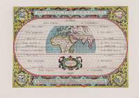
Actions du Soleil et de la Lune considerees comme Causes du Flux et Reflux pour la Geographie Comparee. [Moon and Sun Influence on the Tide / "Flux and Reflux" / 18th century Map].
by Tide [Flux et Reflux] - Anonymus
- Used
- Condition
- Used
- Quantity Available
- 1
- Seller
-
Skibbereen, Ireland
- Item Price
-
£169.12£33.82 shipping to USA
Show Details
Description:
1780. [Paris], c. 1780. Original copper engraving. 27.6 cm x 23 cm. Mounted on paper. Very good condition with only a faint dampstain to the lower left side. With an additional diagram mounted verso: "Equinoxe d'Automne dans ce Siecle" / "Equinoxe d'Automne du temps d'Hipparque" / "Equinoxe du Printems du Temps d'Hipparque" etc.
Item Price
£169.12
£33.82
shipping to USA
More Photos
Aevi veteris, Typus Geographicus.
by World - Ortelius, Abraham. (1527-1598)
- Used
- Condition
- Used
- Quantity Available
- 1
- Seller
-
Skibbereen, Ireland
- Item Price
-
£1,084.12£33.82 shipping to USA
Show Details
Description:
1590. Antwerp, Ortelius, 1590. Original hand-coloured engraving. Plate Size: 44 cm x 31 cm. Sheet Size: 53.7 cm x 38.5 cm. Original map. Very good, actually stunning, condition. Really clean and crisp. Generous margins. Reverse recto carries Latin text. [Shirley 176; Broecke 186.1; Koeman III, 0800H:31]. Beautifully unusual and richly decorated map of the Ancient World based upon the work of Claudius Ptolemy, from Ortelius' Parergon ('Supplement'). The depicted land masses of Europe, Africa and western Asia are largely in their modern configurations, although the place names on the map are based upon Ptolemy. The southern portion of Africa is missing and China is not included on the map. A small number of cities, including Hispalis (Seville), Lutetia (Paris), Rome, Byzantium (Istanbul), Hierusalem (Jerusalem), Alexandria, and Memphis are identified. Relief shown pictorially. The mythical Luna Montes (Mountains of the Moon) - the fabled source of the Nile - can be seen in the southern half of…
Read More Item Price
£1,084.12
£33.82
shipping to USA

More Photos
Alien Trees I".
by Smyth, Nicola Josephine. (*1969)
- Used
- Condition
- Used
- Quantity Available
- 1
- Seller
-
Skibbereen, Ireland
- Item Price
-
£2,081.52£33.82 shipping to USA
Show Details
Description:
2015. Ireland, 2015. Original Artwork / Acrylic on Canvas. Framed: 74 cm wide x 63,5 cm high. Artwork (canvas): 60 cm wide x 50 cm high. Signed. [Includes 13,5% VAT (285,46) Net 2114,54 ]
Item Price
£2,081.52
£33.82
shipping to USA

Alien Trees II".
by Smyth, Nicola Josephine. (*1969)
- Used
- Condition
- Used
- Quantity Available
- 1
- Seller
-
Skibbereen, Ireland
- Item Price
-
£2,081.52£33.82 shipping to USA
Show Details
Description:
2013. Ireland, 2013. Original Artwork / Acrylic on Canvas. Framed: 74 cm wide x 63,5 cm high. Artwork (canvas): 60 cm wide x 50 cm high. Signed. [Includes 13,5% VAT (285,46) Net 2114,54 ]
Item Price
£2,081.52
£33.82
shipping to USA

More Photos
Americae Mappa generalis.
by Americas - Homann, Johann Baptist. (1664 1724)
- Used
- Condition
- Used
- Quantity Available
- 1
- Seller
-
Skibbereen, Ireland
- Item Price
-
£1,110.14£33.82 shipping to USA
Show Details
Description:
1746. Nürnberg, Homann, 1746. Original hand-coloured engraving. Plate Size: 53 cm x 46 cm. Sheet Size: 56.3 cm x 50 cm. Original map. Very good+ condition. Expertly restored map with reinforced edges. Faintest traces of the professional repairs barely evident such is the quality of the restoration. [Lowery 383]. Border with longitudinal and latitudinal information. Decorative title cartouche with allegorical scene includes four indigenous figures in native dress. One male figure with extended arm holds a figurine of a human head. Two hold hunting materials and food while two volcanoes erupt in the background. Flora and fauna point to the riches and fecundity of the continent. Title bears Latin inscription: "Americae mappa generalis: secundum legitimas projectionis stereographicae regulas relationesque recentissimas et observationes socioru Acad. reg. sc quoe Parisiis est aliorumque auctorum nec non secundum mentern D.I.M. Hasii MPP. in partes suas methodicas divisa nunc concinnata et…
Read More Item Price
£1,110.14
£33.82
shipping to USA

More Photos
Ansicht der Westminster Abbey zu London.
by London - [Anonymous]
- Used
- Condition
- Used
- Quantity Available
- 1
- Seller
-
Skibbereen, Ireland
- Item Price
-
£121.42£33.82 shipping to USA
Show Details
Description:
1795. Germany, [no year / c. 1795]. Original hand engraving. Plate Size: 19 cm x 15 cm. Sheet Size: 23 cm x 20 cm. Original engraving. In good+ condition with only some browning to outter margins. A beautiful engraving of the world-famous Westminster Abbey in London. The building's monumental scale is stunningly illustrated by the engraver's inclusion of strollers in the foreground.
Item Price
£121.42
£33.82
shipping to USA

More Photos
Arabia (Arabian Peninsula / Gazirat al-Arab) with the Arabian Gulf / Red Sea. With Vignettes an illustrations of Mount Sinai, Arab Women, Arabs. The map shows Oman, El Hassa, El Jebel, Arabia Felix, Arabia Petraea, El Yemen (Jemen), El Hejaz.
by Tallis, John / Rapkin, John. (1817 - 1876)
- Used
- Condition
- Used
- Quantity Available
- 1
- Seller
-
Skibbereen, Ireland
- Item Price
-
£303.56£33.82 shipping to USA
Show Details
Description:
1851. London & New York, J & F. Tallis, 1851. Original steel engraving / Vintage map. Drawn and engraved by John Rapkin. Partly hand-coloured. Beautifully Framed. Size of frame with map: Size of the actual map: 27 cm x 37 cm. Excellent condition. John Tallis (7 November 1817 3 June 1876) was an English cartographic publisher. His company, John Tallis and Company, published views, maps and atlases in London from roughly 1838 to 1851. Tallis set up as a publisher with Frederick Tallis in Cripplegate in 1842; the business moved to Smithfield in 1846, and was dissolved in 1849. From 1851 to 1854 Tallis operated as John Tallis and Company. He started The illustrated news of the world and national portrait gallery of eminent personages in 1858, selling it for £1,370 in 1861; it folded in 1863. (Wikipedia) The most important project John Tallis undertook, was the 'Illustrated Atlas' from 1851. The original map we offer here, was part of this exceptional Atlas and all the maps it contained are still…
Read More Item Price
£303.56
£33.82
shipping to USA

More Photos
The Art of Shaliapin - [8 Vinyl Records (complete set) with two pages of an essay about "The Art of Fedor Shaliapin" by Irakly Andronikov].
by Shaliapin, Feodor Ivanovich / Chaliapin, Feodor Ivanovich. (1873 - 1938)
- Used
- Condition
- Used
- Quantity Available
- 1
- Seller
-
Skibbereen, Ireland
- Item Price
-
£156.11£33.82 shipping to USA
Show Details
Description:
1975. Russia (USSR), c.1975. Eight (8) original, vintage Vinyl in original slipcase. 8 Records. Excellent condition of Box and Records with only minor signs of wear to the sleeve / Sleeve VG + / Record Near Mint. Feodor Ivanovich Chaliapin (Russian: Fyodor Ivanovich Shalyapin; February 13 [O.S. February 1] 1873 April 12, 1938) was a Russian opera singer. Possessing a deep and expressive bass voice, he enjoyed an important international career at major opera houses and is often credited with establishing the tradition of naturalistic acting in his chosen art form. During the first phase of his career, Chaliapin endured direct competition from three other great basses: the powerful Lev Sibiriakov [ru; uk; pl; ca] (18691942), the more lyrical Vladimir Kastorsky (18711948), and Dmitri Buchtoyarov (18661918), whose voice was intermediate between those of Sibiriakov and Kastorsky. The fact that Chaliapin is far and away the best remembered of this magnificent quartet of rival basses is a…
Read More Item Price
£156.11
£33.82
shipping to USA

More Photos
Asia - With Vignettes of Petra, Tartars, Russian Peasants, The Walrus, Sun-Birds of India and the Philippine Isles.
by Asia - Tallis, John / Rapkin, John. (1817 - 1876)
- Used
- Condition
- Used
- Quantity Available
- 1
- Seller
-
Skibbereen, Ireland
- Item Price
-
£325.24£33.82 shipping to USA
Show Details
Description:
1851. London, Edinburgh & Dublin, J & F. Tallis, 1851. Original steel engraving / Vintage map. Drawn and engraved by John Rapkin. Partly hand-coloured. Illustrations by J. Marchant and Engraved by J.B. Allen. Plate Size: 31.8 cm x 25.5 cm. Sheet Size: 37.2 cm x 27.2 cm. Vintage 19th century map in very good condition. Beautiful map of Asia from the famous Victorian publisher. Coloured delineation illustrate the political landscape. In the West Turkey and Arabia and Persia are shown. Beloochistan, Cabool, Punjaub and Independent Tartary link the vast Russian Empire, spanning Siberia Iakoutsk, to Hindoostan in the Indian subcontinent. Nepal, Bhutan and Tibet are shown in and around the Chinese Empire, which also includes Mongolia. To the south Burma, Siam, Laos, Cochin China and Malaya can all be seen. Off the landmass are the archipelagos of Japan, Formosa, the Philippines, and Indonesia (Isles of Sunda) and Ceylon. Large and small islands Borneo, Celebes, Java, Papua or Guinea and Mundanao and New…
Read More Item Price
£325.24
£33.82
shipping to USA

More Photos
Asia Minor (Turkey / Anatolia with the North of Syria and Armenia and the Armenian Highlands) with Vignettes and illustrations of Mount Olympus, Rhodes. Showing the historical provinces of Turkey: Anadolia (Anatolia), Rum or Sivas, Themisonde, Aleppo, Itshili, Adana, Kharidj Karamania, Cyprus. With the Sea of Marmara and the Southern Black Sea.
by Tallis, John / Rapkin, John. (1817 - 1876)
- Used
- Condition
- Used
- Quantity Available
- 1
- Seller
-
Skibbereen, Ireland
- Item Price
-
£303.56£33.82 shipping to USA
Show Details
Description:
1851. London & New York, J & F. Tallis, 1851. Original steel engraving / Vintage map. Drawn and engraved by John Rapkin. Partly hand-coloured. Beautifully Framed. Size of Frame with map: 49 cm x 39 cm. Size of the actual map: 27 cm x 37 cm. Very good condition. John Tallis (7 November 1817 3 June 1876) was an English cartographic publisher. His company, John Tallis and Company, published views, maps and atlases in London from roughly 1838 to 1851. Tallis set up as a publisher with Frederick Tallis in Cripplegate in 1842; the business moved to Smithfield in 1846, and was dissolved in 1849. From 1851 to 1854 Tallis operated as John Tallis and Company. He started The illustrated news of the world and national portrait gallery of eminent personages in 1858, selling it for £1,370 in 1861; it folded in 1863. (Wikipedia) The most important project John Tallis undertook, was the 'Illustrated Atlas' from 1851. The original map we offer here, was part of this exceptional Atlas and all the maps it…
Read More Item Price
£303.56
£33.82
shipping to USA

More Photos
At the Crossroads of Growth".
by Smyth, Nicola Josephine. (*1969)
- Used
- Condition
- Used
- Quantity Available
- 1
- Seller
-
Skibbereen, Ireland
- Item Price
-
£3,035.55£33.82 shipping to USA
Show Details
Description:
2006. Ireland, 2006. Original Artwork / Acrylic on Canvas. Framed: 71 cm wide x 90 cm high. Artwork (canvas): 60 cm wide x 80 cm high. Signed. [Includes 13,5% VAT (416,30) Net 3083,70 ]
Item Price
£3,035.55
£33.82
shipping to USA

More Photos
At the Oval" - General View of the famous, international Cricket Ground "Oval" at Kennington for Surrey County Cricket Club.
by Cricket - [Anonymous]
- Used
- Condition
- Used
- Quantity Available
- 1
- Seller
-
Skibbereen, Ireland
- Item Price
-
£104.08£33.82 shipping to USA
Show Details
Description:
1900. [Bavaria], c. 1900. Vintage, photographical Postcard. 13.5 cm x 8.5 cm. Excellent condition with only a minor abrasion. The Oval, known for sponsorship reasons as the Kia Oval, is an international cricket ground in Kennington, in the London Borough of Lambeth, in south London. The Oval has been the home ground of Surrey County Cricket Club since it was opened in 1845. It was the first ground in England to host international Test cricket in September 1880. The final Test match of the English season is traditionally played there. In addition to cricket, The Oval has hosted a number of other historically significant sporting events. In 1870, it staged England's first international football match, versus Scotland. It hosted the first FA Cup final in 1872, as well as those between 1874 and 1892. In 1876, it held both the England v. Wales and England v. Scotland rugby international matches and, in 1877, rugby's first varsity match. It also hosted the final of the 2017 ICC Champions Trophy. (Wikipedia)
Item Price
£104.08
£33.82
shipping to USA

Didn’t find what you’re looking for?
Try adding this search to your want list. Millions of books are added to our site everyday and when we find one that matches your search, we’ll send you an email. Best of all, it’s free.
Add to Want List

Are you a frequent reader or book collector?
Join the Bibliophile's Club and save 10% on every purchase, every day — up to $20 savings per order!

Social Responsibility
Did you know that since 2004, Biblio has used its profits to build 16 public libraries in rural villages of South America?
