Description:
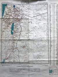
Folding colour map, scale 1:750,000. some splits on folds,
ROAD MAP OF THE HASHEMITE KINGDOM OF JORDAN by Jordan - 1969
by Jordan
Similar copies are shown below.
Similar copies are shown to the right.
ROAD MAP OF THE HASHEMITE KINGDOM OF JORDAN
by Jordan
- Used
- very good
- first
Jordan: Army Map Service, 1969. First Edition. Very Good. Full-color road map with place names in English and Jordanian Arabic. Compiled and drawn in 1969 by the Dept. of Lands and Surveys of Jordan. Includes Israel and part of Syria. Location of sites in English and Arabic. Sites of antiquities are marked in red. Original folds, now rolled, opens to 30" x 24". The gray portion of the images is a shadow, not integral to the map.
-
Bookseller
R & A Petrilla
 (US)
(US)
- Book Condition Used - Very Good
- Quantity Available 1
- Edition First Edition
- Publisher Army Map Service
- Place of Publication Jordan
- Date Published 1969
- Keywords kingdom of jordan; middle east; maps
We have 1 copies available starting at £20.00.

Road Map The Hashemite Kingdom of Jordan.
by JORDAN. ROYAL JORDANIAN GEOGRAPHIC CENTRE
- Used
- Condition
- Used
- Quantity Available
- 1
- Seller
-
Ilminster, Somerset, United Kingdom
- Item Price
-
£20.00
Show Details
Item Price
£20.00