Description:
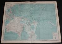
The Times, London, 1920. First Edition. Softcover. Very Good Condition/No Dust Jacket. Disbound single sheet with vertical centre fold from the 1920 "The Times Survey Atlas of the World". Map is in colour and sheet is suitable for framing. Land is coloured grey and sea is shades of blue according to depth. Map contains major currents/streams and directions are indicated by small arrows. Key shipping routes are marked. Mapped area includes; South Pacific Ocean, North and South Equatorial Currents, Equatorial Counter Current, Micronesia, Melanesia and Oceania, Australia, Tasmania, Hawaii, Papua New Guinea, Philippines, New Zealand, Fiji, Tonga, New Hebrides, Caroline Islands, East Indian Archipelago, Marquesas Islands, Chatham Island, Tuamotu or Low Archipelago, Lin Kin Islands, Magelhaes Archipelago, Soloman Islands, Bismark Archipelago, etc. Sheet has slightly darkened edges with occasional light foxing in the margins and edges of the mapped area. Sheet is otherwise clean and bright.…
Read More Pacific Ocean Atlas Plate 61: April, 1962 Compiled & Drawn In The Cartographic Section Of The National Geographic Society For The National Geographic Magazine (Map) -
Similar copies are shown below.
Similar copies are shown to the right.

Pacific Ocean Atlas Plate 61: April, 1962 Compiled & Drawn in the Cartographic Section of the National Geographic Society for the National Geographic Magazine (Map)
- Used
National Geographic Magazine, 1962, folded color map, rubbed, G $
-
Bookseller
Independent bookstores
 (US)
(US)
- Book Condition Used
- Keywords maps geography
We have 1 copies available starting at £24.00.
More Photos
Map of South Pacific Ocean from the 1920 Times Atlas (Plate 102) including Australia, Hawaii, Papua New Guinea, Philippines, New Zealand, Fiji, Tonga, New Hebrides, Caroline Islands, East Indian Archipelago, Marquesas Islands, etc
by The Times and J. G. Bartholomew
- Used
- Paperback
- first
- Condition
- Used - Very Good Condition
- Jacket Condition
- No Dust Jacket
- Edition
- First Edition
- Binding
- Paperback
- Quantity Available
- 1
- Seller
-
Doncaster, Aberdeen, United Kingdom
- Item Price
-
£24.00
Show Details
Item Price
£24.00