
Click for full-size.
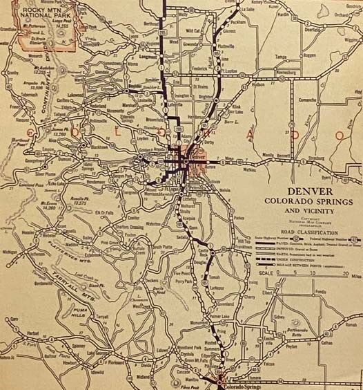
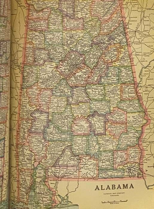
Official Paved Road and Commercial Survey of the United States: Sectional Road Maps Covering the Entire United States and Lower Canada - Complete Series of State Maps in Colors for Commercial Reference - a Double Page United States Map Showing Transcontinental Highways - Logs, Transcontinental Federal Highways - Map and Information Concerning Air Mail and Air Express - Maps of Principal Cities in the United States Showing Main Highways - Ready Reference Index Locating Cities, Towns and Villages with Population According to Latest Federal Census - Descriptive Gazetteer of United States and Territorial Possessions
by National Map Company
- Used
- good
- Paperback
- Condition
- Good
- Seller
-
Webster, New York, United States
Payment Methods Accepted
About This Item
Indianapolis: National Map Company, 1929. Reprint. Large Softcover. Good. 0x0x0. Edition 1283.' Corners worn, covers a bit soiled, crease to bottom corner. 1929 Large Softcover. xlviii, 29-116 pp. Fabricoid cover over post-bound text block. Ten publisher coupons for ordering of revised maps bound in after text. A particularly important road atlas, in that it is among the first to include the newly numbered federal highway system -- the Bureau of Public Roads and the Federal Highway Administration teamed up to accomplish these name changes in 1925 (State Planning & Research Guide, Vol. 59, No. 4, Spring 1996). OCLC lists four different editions of this title, printed in 1928, 1929, 1931, and 1935. The first two are based on the 1920 census, the second two on the 1930 census. The 1929 edition is designated as 'Edition 1263'. Also includes two pages on national parks, an extensive index, and gazetteer.
Reviews
(Log in or Create an Account first!)
Details
- Bookseller
- Yesterday's Muse Books
 (US)
(US)
- Bookseller's Inventory #
- 2331806
- Title
- Official Paved Road and Commercial Survey of the United States: Sectional Road Maps Covering the Entire United States and Lower Canada - Complete Series of State Maps in Colors for Commercial Reference - a Double Page United States Map Showing Transcontinental Highways - Logs, Transcontinental Federal Highways - Map and Information Concerning Air Mail and Air Express - Maps of Principal Cities in the United States Showing Main Highways - Ready Reference Index Locating Cities, Towns and Villages with Population According to Latest Federal Census - Descriptive Gazetteer of United States and Territorial Possessions
- Author
- National Map Company
- Format/Binding
- Large Softcover
- Book Condition
- Used - Good
- Quantity Available
- 1
- Edition
- Reprint
- Binding
- Paperback
- Publisher
- National Map Company
- Place of Publication
- Indianapolis
- Date Published
- 1929
- Size
- 0x0x0
- Weight
- 2.38 lbs
- Keywords
- MAPS CARTOGRAPHY GEOGRAPHY ATLAS UNITED STATES AMERICANA AMERICAN GEOGRAPHIC U.S
Terms of Sale
Yesterday's Muse Books
Unless alternate arrangements have been made, payment is expected at the time of purchase. We accept payment by credit card, PayPal, check, or money order. All orders are shipped promptly and securely packed in boxes to avoid damage during shipment.
Shipping costs stated are estimates. Large sets or particularly heavy items may require additional postage, especially for priority or international service.
All items are guaranteed to be as described (this includes condition, edition, authenticity of signatures, etc.). If you are not satisfied with your order, please contact us and we will be happy to work with you.
About the Seller
Yesterday's Muse Books
Biblio member since 2005
Webster, New York
About Yesterday's Muse Books
Yesterday's Muse Inc. is an independent used & rare bookseller that has been in operation for over 15 years. We opened our first 'brick and mortar' storefront in December of 2008 in our hometown of Webster, NY.Owner Jonathan Smalter is a member of the Antiquarian Booksellers' Association of America (ABAA), former vice president of the Independent Online Booksellers Association (IOBA), both of which are trade organizations created to promote ethical online selling practices, and to encourage continuing education among fellow booksellers. He is also a 2011 graduate of the Colorado Antiquarian Book Seminar (CABS). He has nearly 20 years of experience in the book trade, during which time he has become adept at evaluating used and collectible books.
Glossary
Some terminology that may be used in this description includes:
- Text Block
- Most simply the inside pages of a book. More precisely, the block of paper formed by the cut and stacked pages of a book....
- Reprint
- Any printing of a book which follows the original edition. By definition, a reprint is not a first edition.
- Soiled
- Generally refers to minor discoloration or staining.

May the Fourth Be With You!
As the Star Wars franchise continues to grow, change, and churn out money-making film after film now under the control of Disney, we can bet that the desire to own Star Wars collectibles will also continue to grow. Check out our gallery of goodies from a galaxy far, far away...
Collecting and identifying signed letters and holographic documents
Many authors and other famous literary figures wrote and signed letters by hand, and you can find a great collection of them in the Biblio rare book room. See our great collection of handwritten letters and holographic documents