Description:
New York: Illman & Pilbrow, 1835. unbound. very good. Map. Engraving with original hand coloring. Image measures 12.75" x 10.5".<br/><br/> Shows Lake Titicaca as Bolivian, whereas modern borders share it with Peru.<br/><br/>
Northern Hemisphere. Southern Hemisphere by BURR, David H - 1835
by BURR, David H

Northern Hemisphere. Southern Hemisphere
by BURR, David H
- Used
- very good
New York: Illman & Pilbrow, 1835. unbound. very good. Map (diptych). Two engravings with original hand coloring. Each page measures 15" x 12 3/8".<br/><br/> Great world map set, showing the Northern and Southern Hemispheres. Both sheets in very good condition, with only minor aging and a few small tears to edges.<br/><br/>
-
Bookseller
Argosy Book Store
 (US)
(US)
- Format/Binding Unbound
- Book Condition Used - very good
- Quantity Available 1
- Publisher Illman & Pilbrow
- Place of Publication New York
- Date Published 1835
- Keywords North pole, South pole
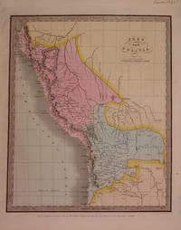
Peru and Bolivia
by BURR, David H
- Used
- very good
- Condition
- Used - very good
- Quantity Available
- 2
- Seller
-
New York, New York, United States
- Item Price
-
£88.84
Show Details
Item Price
£88.84
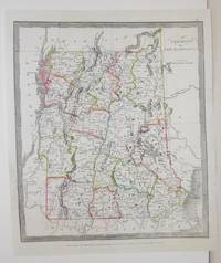
Vermont and New Hampshire
by Burr, David H
- Used
- Condition
- Used - Good; some restoration in the lower left corner
- Quantity Available
- 1
- Seller
-
Toronto, Ontario, Canada
- Item Price
-
£117.10
Show Details
Description:
New York: Illman, Thomas, 1836. Good; some restoration in the lower left corner. Notes: From David Burr's "A new Universal Atlas comprising Separate Maps of all the Principal Empires, Kingdoms & States Throughought the World", 1836, New York., Size : 340x290 (mm), 13.375x11.375 (Inches), Coloring: Original Outline Coloring, Category: Maps United States New England (States);
Item Price
£117.10

Map of the County of Clinton
by BURR, David H
- Used
- Condition
- Used - very good(+)
- Quantity Available
- 1
- Seller
-
New York, New York, United States
- Item Price
-
£141.33
Show Details
Description:
New York: DeWitt, Simeon, 1829. unbound. very good(+). Rawdon Clark & Co.. Map. Copper plate engraving with original hand coloring. Image measures 18.5" x 17".<br/><br/> Nice map of Clinton County in northern New York. Denotes townships, major routes, waterways and towns. In excellent condition with some wear to corners. David H. Burr (1803-1875) served as Topographer to the United States Post Office and Geographer to the House of Representatives and was widely known for his accuracy and attention to detail. This atlas was among the first to map each of the United States individually. Included is a separate page with statistical information and a historical description of Clinton County. Please visit our Gallery for more Burr New York county maps.<br/><br/>
Item Price
£141.33

United States
by David H. Burr
- Used
- very good
- Condition
- Used - Very Good
- Quantity Available
- 1
- Seller
-
king of Prussia, Pennsylvania, United States
- Item Price
-
£151.42
Show Details
Description:
B. Davenport, New York, 1842, 1842. MAP. Very Good. Hand colored map. Environs of Baltimore, Washington, Philadelphia, New York, Cincinnati, Albany, Boston. Some slight marking on map. 22x18 inches.
Item Price
£151.42
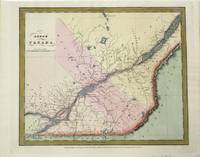
Lower Canada.
by Burr, David H
- Used
- very good
- Condition
- Used - Very Good
- Quantity Available
- 1
- Seller
-
Toronto, Ontario, Canada
- Item Price
-
£141.33
Show Details
Description:
New York: Illman & Pilbrow, 1834. Very Good. Size : 293x350 (mm), 11.54x13.78 (Inches), Coloring: Hand Colored, Category: Maps Canada East Quebec;
Item Price
£141.33
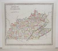
Kentucky and Tennessee.
by Burr, David H
- Used
- Condition
- Used - Excellent
- Quantity Available
- 1
- Seller
-
Toronto, Ontario, Canada
- Item Price
-
£141.33
Show Details
Description:
New York: Illman, Thomas, 1836. Excellent. Notes: From David Burr's "A new Universal Atlas comprising Separate Maps of all the Principal Empires, Kingdoms & States Throughought the World", 1836, New York., Size : 294x293 (mm), 11.625x11.5 (Inches), Coloring: Original Outline Coloring, Category: Maps United States South (States); Maps United States Midwest (States);
Item Price
£141.33
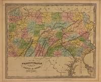
Pennsylvania
by BURR, David H
- Used
- Condition
- Used
- Quantity Available
- 1
- Seller
-
New York, New York, United States
- Item Price
-
£161.52
Show Details
Description:
New York: Illman and Pilbrow, 1834. unbound. Thomas Illman. Map. Engraving with original hand coloring. Image measures 10 1/2" x 12 5/8"<br/> <br/> Early map of Pennsylvania, beautifully hand colored to show county divisions. Cities, towns, major routes, topograhical features, islands, and waterways are labeled. In very good condition. Mat burn to margins.<br> <br> David H. Burr (1803-1875) served as Topographer to the United States Post Office and Geographer to the House of Representatives and was widely known for his accuracy and attention to detail. His "Universal Atlas" was the first to map each of the United States individually.<br/> <br/>
Item Price
£161.52
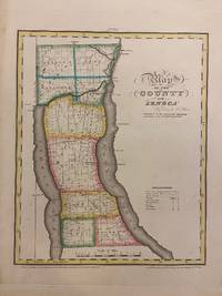
Map of the County of Seneca
by BURR, David H
- Used
- Condition
- Used
- Quantity Available
- 1
- Seller
-
New York, New York, United States
- Item Price
-
£201.90
Show Details
Description:
New York: David H. Burr, 1829. unbound. Rawdon Clark & Co.. Map. Copper plate engraving with original hand-coloring. Image measures 11 3/4 x 14 1/2 inches.<br/> <br/> This map depicts Seneca County in eastern New York, divided into 9 towns outlined in vivid color. Seneca Falls is named as is the Cayuga%u2013Seneca Canal. The map denotes major routes, waterways, and topographical details, and icons label villages, flouring mills, factories, forges, saw mills, and churches. This first edition of Burr's county map appeared in his "Atlas of the State of New York" of the same year, which was the second atlas of an individual state ever published.<br> <br> The map is in good condition with light foxing throughout. Full original margins.<br> <br> David H. Burr (1803-1875) served as Topographer to the United States Post Office and Geographer to the House of Representatives and was widely known for his accuracy and attention to detail. His "Universal…
Read More Item Price
£201.90
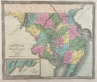
Delaware and Mary-land
by BURR, David H
- Used
- Condition
- Used
- Quantity Available
- 1
- Seller
-
New York, New York, United States
- Item Price
-
£201.90
Show Details
Description:
New York: Illman and Pilbrow, 1833. unbound. Thomas Illman. Map. Engraving with original hand coloring. Image measures 10 1/2" x 12 5/8"<br/> <br/> Early map of Delaware and Maryland, beautifully hand colored to show county divisions. Cities, towns, major routes, topograhical features, islands, and waterways are labeled. An inset in the lower left shows the Western Part of Maryland. <br> <br> David H. Burr (1803-1875) served as Topographer to the United States Post Office and Geographer to the House of Representatives and was widely known for his accuracy and attention to detail. His "Universal Atlas" was the first to map each of the United States individually.<br/> <br/>
Item Price
£201.90
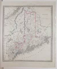
Maine.
by Burr, David H
- Used
- Condition
- Used - Excellent
- Quantity Available
- 1
- Seller
-
Toronto, Ontario, Canada
- Item Price
-
£201.90
Show Details
Description:
New York: Illman, Thomas, 1836. Excellent. Notes: From David Burr's "A new Universal Atlas comprising Separate Maps of all the Principal Empires, Kingdoms & States Throughought the World", 1836, New York., Size : 304x268 (mm), 12x10.5 (Inches), Coloring: Original Outline Coloring, Category: Maps United States New England (States);
Item Price
£201.90