![A Map of Parts of Jefferson and Lewis Counties, in the State of New York. Drawn on Stone, by H. Van Merrbeke [ca. 1855?]. Plat Map, 18 1/2 X 24, with Town Boundaries and Lakes and Rivers Colored and with Sections of Lots Washed in Yellow and Green](https://d3525k1ryd2155.cloudfront.net/h/535/523/1471523535.0.m.jpg)
Click for full-size.
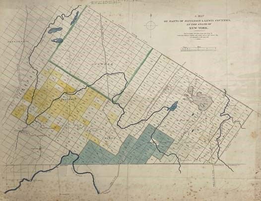
A Map of Parts of Jefferson and Lewis Counties, in the State of New York. Drawn on Stone, by H. Van Merrbeke [ca. 1855?]. Plat Map, 18 1/2 X 24, with Town Boundaries and Lakes and Rivers Colored and with Sections of Lots Washed in Yellow and Green
by [No Author]
- Used
- very good
- Condition
- Very Good
- Seller
-
Webster, New York, United States
Payment Methods Accepted
About This Item
S.N, 1855. Single Sheet. Very Good. Meerbeke, H. Van. Folded in quarters, some spotty foxing and light dust-soiling in margins. With a couple of ink annotations in a contemporary hand relating to earlier land transactions of Chaissain(?) and G. & R. Morris. Map supported with posterboard and protected with plastic sleeve. 1855 Single Sheet. 18 1/2 x 24 inches. Being territory about 25 miles northeast of Watertown, N.Y. and 65 miles north of Utica, lying in the townships of Antwerp, Philadelphia, leRay, Wilna and Diana, an area which includes present-day Fort Drum and remains one of the most sparsely populated in the state. The land has been divided here into approximately 900 numbered lots of 440 acres each. The routes of the Odgensburg and the St. Lawrence turnpikes are given, as is the "Military Road" from Sacketts Harbor to Ogdensburg passing through Alexandria to the west. The Indian River bisects the map from west to east while a portion of the Black River forms the southwest boundary and the Oswegatchee River passes through the eastern edge. Someone has pencilled a date of "ca. 1855" and this seems about right: the township of Antwerp, e.g., was incorporated in 1853. Communities noted include Evans Mills, Leraysville, Felts Mills and Great Bend on the Black River, Champion and Carthage (both being outside the southern boundary here), Wilna, Natural Bridge, Lewisburg, Harrisburg, Antwerp, Theresa (outside the western boundary), and Philadelphia. For some reason, the largest lake here, "Lake Joseph or Diana" (now Lake Bonaparte) has been left uncolored.
Reviews
(Log in or Create an Account first!)
Details
- Bookseller
- Yesterday's Muse Books
 (US)
(US)
- Bookseller's Inventory #
- 2324481
- Title
- A Map of Parts of Jefferson and Lewis Counties, in the State of New York. Drawn on Stone, by H. Van Merrbeke [ca. 1855?]. Plat Map, 18 1/2 X 24, with Town Boundaries and Lakes and Rivers Colored and with Sections of Lots Washed in Yellow and Green
- Author
- [No Author]
- Illustrator
- Meerbeke, H. Van
- Format/Binding
- Single Sheet
- Book Condition
- Used - Very Good
- Quantity Available
- 1
- Publisher
- S.N
- Date Published
- 1855
- Weight
- 0.75 lbs
- Keywords
- MAP ATLAST JEFFERSON COUNTY LEWIS COUTNY NEW YORK LOCAL REGIONAL AMERICANA AMERICAN HISTORY
Terms of Sale
Yesterday's Muse Books
Unless alternate arrangements have been made, payment is expected at the time of purchase. We accept payment by credit card, PayPal, check, or money order. All orders are shipped promptly and securely packed in boxes to avoid damage during shipment.
Shipping costs stated are estimates. Large sets or particularly heavy items may require additional postage, especially for priority or international service.
All items are guaranteed to be as described (this includes condition, edition, authenticity of signatures, etc.). If you are not satisfied with your order, please contact us and we will be happy to work with you.
About the Seller
Yesterday's Muse Books
Biblio member since 2005
Webster, New York
About Yesterday's Muse Books
Yesterday's Muse Inc. is an independent used & rare bookseller that has been in operation for over 15 years. We opened our first 'brick and mortar' storefront in December of 2008 in our hometown of Webster, NY.Owner Jonathan Smalter is a member of the Antiquarian Booksellers' Association of America (ABAA), former vice president of the Independent Online Booksellers Association (IOBA), both of which are trade organizations created to promote ethical online selling practices, and to encourage continuing education among fellow booksellers. He is also a 2011 graduate of the Colorado Antiquarian Book Seminar (CABS). He has nearly 20 years of experience in the book trade, during which time he has become adept at evaluating used and collectible books.
Glossary
Some terminology that may be used in this description includes:
- G
- Good describes the average used and worn book that has all pages or leaves present. Any defects must be noted. (as defined by AB...
This Book’s Categories

Handling and Storing Books
Take care of your old books — vintage, antiquarian, and fine — with these tips from a professional bookseller

Collecting Banned & Challenged Books
Build a revolutionary library of literature that has been challenged or even outright banned. You’ll be surprised by some of the titles in this gallery!
Also Recommended
-

-

-

-

-

Save 10% on every purchase!
Join the Bibliophiles’ Club and start saving 10% on every book.
$29.95 / Year