
Click for full-size.
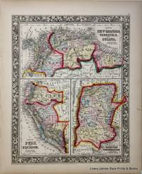
Map of New Granada, Venezuela and Guiana, Map of Peru and Equador, Map of the Argentine Confederation: New Universal Atlas
by S. Augustus Mitchell, Jr
- Used
- Fine
- first
- Condition
- Fine
- Seller
-
Langley, Washington, United States
Payment Methods Accepted
About This Item
Philadelphia:: S. Augustus Mitchell, Jr,, 1860.. First edition. Fine . Fine original hand-colored lithograph. Folio (15.5 x 12.75 inches).
A fine and decorative pre-Civil War Map from one of America's most prolific atlas publishing firms of the nineteenth century; Samuel Augustus Mitchell, (Connecticut 1792-1868), and his son S. Augustus Mitchell, Jr. Drawn and engraved by W. Williams, this map is from the first edition of the popular New Universal Atlas which characterized by the fine topographical detail of the charted territory here heightened with rich watercolor, all surrounded by an embellished floral border. Single Sheet
Reviews
(Log in or Create an Account first!)
Details
- Bookseller
- Lowry-James Rare Prints & Books
 (US)
(US)
- Bookseller's Inventory #
- 6980
- Title
- Map of New Granada, Venezuela and Guiana, Map of Peru and Equador, Map of the Argentine Confederation
- Author
- S. Augustus Mitchell, Jr
- Book Condition
- Used - Fine
- Quantity Available
- 1
- Edition
- First edition
- Publisher
- S. Augustus Mitchell, Jr,
- Place of Publication
- Philadelphia:
- Date Published
- 1860.
- Keywords
- Samuel Augustus Mitchell, Jr. MAP OF NEW GRANADA, VENEZUELA AND GUIANA, MAP OF PERU AND EQUADOR AND MAP OF THE ARGENTINE CONFEDERATION hand-colored lithograph THE NEW UNIVERSAL ATLAS. 19th Century Atlas Gambel, W. H. , W. Williams Map
Terms of Sale
Lowry-James Rare Prints & Books
We accept Master Card, Visa, American Express, PayPal and Checks. We ship via US Postal Priority, fully insured, with tracking. Insurance over $100 value is additional on all purchases.
About the Seller
Lowry-James Rare Prints & Books
Biblio member since 2006
Langley, Washington
About Lowry-James Rare Prints & Books
Established in 1986, Lowry-James Rare Prints & Books features original engravings and lithographs from the 17th through the 19th Centuries including original work by John James Audubon, early Natural History Prints, Botany and Horticulture, Maps and Cartography.
Glossary
Some terminology that may be used in this description includes:
- Fine
- A book in fine condition exhibits no flaws. A fine condition book closely approaches As New condition, but may lack the...
- New
- A new book is a book previously not circulated to a buyer. Although a new book is typically free of any faults or defects, "new"...
- First Edition
- In book collecting, the first edition is the earliest published form of a book. A book may have more than one first edition in...
- Folio
- A folio usually indicates a large book size of 15" in height or larger when used in the context of a book description. Further,...
Frequently asked questions

Collecting Nebula Award Winners of the 1980s
The Nebula Award has been awarded to stories in the Science Fiction and Fantasy genre every year since 1966. Learn about the winners of the 1980s!

Browse rare books
Interested in rare and collectible books? Booksellers from around the world showcase some of their finest in Biblio’s rare book room.