
Click for full-size.
L' Afrique Divisee En Ses Principaux Etats...
by Janvier, Sieur Jean
- Used
- Condition
- See description
- Seller
-
Florham Park, New Jersey, United States
Payment Methods Accepted
About This Item
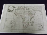
Double page engraved map (29" x 21"), hand colored in outline, decorative cartouche. Some chips and tears in margins, but margins are wide, a little creasing around the centerfold, minor aging; otherwise about very good, bright and with a strong impression. Janvier was a French geographer that was active in the second half of the 18th century. According to Norwich and Tooley, Janvier produced a series of maps in 1760, and collaborated in an Atlas Moderne in 1762 and 1771.The present map is number 28 from that atlas. This rather handsome engraved map, which has full color, appears to present the cartographic knowledge of Africa in the mid 18th century. The present map was originally published in 1762, in a slightly smaller version. However, this edition appears to have has greater detail, and this is especially true in the interior and southern portion of the continent. There is a decorative cartouche in the upper left corner that features a lion coming out of the jungle. Norwich 104. Tooley p. 59.
Details
- Bookseller
- Nicholas D. Riccio Rare Books & Prints
 (US)
(US)
- Bookseller's Inventory #
- 104175
- Title
- L' Afrique Divisee En Ses Principaux Etats...
- Author
- Janvier, Sieur Jean
- Book Condition
- Used
- Quantity Available
- 1
- Publisher
- Remondin,
- Place of Publication
- Venice:
- Date Published
- c1784.
- Keywords
- Maps of Africa. Janvier, Sieur Jean.
Terms of Sale
Nicholas D. Riccio Rare Books & Prints
30 day return guarantee, with full refund including shipping costs for up to 30 days after delivery if an item arrives misdescribed or damaged.
About the Seller
Nicholas D. Riccio Rare Books & Prints
Biblio member since 2011
Florham Park, New Jersey
About Nicholas D. Riccio Rare Books & Prints
Established in 1999 we specialize in Americana, African Americana, Natural History, Travel & Exploration, Science & Medicine, and Maps & Atlases
Glossary
Some terminology that may be used in this description includes:

The Importance of Dust Jackets
Is the dust jacket of a book worth holding on to? Consider its form, its function, and its beauty. Learn more about dust jackets and their importance to your collection.

Is your family bible valuable?
While they may have sentimental value, bibles passed down through the family are not often worth a lot of money. Learn more...