Description:
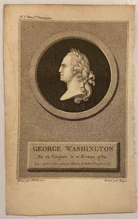
Paris: Maradan, 1801. Print. Uncolored engraving Image measures 6" x 4 1/8"<br/><br/> This bust of George Washington was published as the frontispiece to "Voyage dans la Haute Pensylvanie et dans l'etat de New-York" by Michel Crevecoeur. In this portrait, Washington's left profile is depicted on a medallion. Pierre Francois Tardieu (1711-1771) came from a family of engravers and map makers based in Paris.<br/><br/>
Kesketomah by TARDIEU, Pierre Francois - 1801
by TARDIEU, Pierre Francois

Kesketomah
by TARDIEU, Pierre Francois
- Used
Paris: Maradan, 1801. Print. Stipple engraving. Page measures 7 5/8" x 4 3/4"<br/><br/> This fine portrait of from 1801 of Onondaga chief Kesketomah was published in "Voyage dans la Haute Pensylvanie et dans l'etat de New-York" by Michel Crevecoeur. According to his account, Crevecoeur witnessed an Indian council between the Onondaga and Oneida chiefs in 1789. Engraved by Barthelemy Roger. Pierre Francois Tardieu (1711-1771) came from a family of engravers and map makers based in Paris.<br/><br/>
-
Bookseller
Argosy Book Store
 (US)
(US)
- Book Condition Used
- Quantity Available 1
- Publisher Maradan
- Place of Publication Paris
- Date Published 1801
- Keywords onondoga
George Washington
by TARDIEU, Pierre Francois
- Used
- Condition
- Used
- Quantity Available
- 1
- Seller
-
New York, New York, United States
- Item Price
-
£80.93
Show Details
Item Price
£80.93

l'Aigle a tete chauve enlevant la proie de l'Aigle Pecheur
by TARDIEU, Pierre Francois
- Used
- Condition
- Used
- Quantity Available
- 1
- Seller
-
New York, New York, United States
- Item Price
-
£133.53
Show Details
Description:
Paris: Maradan, 1801. Print. Uncolored engraving. Plate measures 6 5/8" x 8 1/2"<br/><br/> This striking engraving was published in "Voyage dans la Haute Pensylvanie et dans l'etat de New-York" by Michel Crevecoeur. The print depicts two bald eagles competing for a fish. A fort or settlement is visible, and a large ship floats prominently in the water. Pierre Francois Tardieu (1711-1771) came from a family of engravers and map makers based in Paris.<br/><br/>
Item Price
£133.53

Encyclopédie des enfans, ou abrégé de toutes les sciences
by MASSON, J. –R – TARDIEU, Pierre François (1711-1771), engr
- Used
- very good
- Hardcover
- Condition
- Used - Very Good
- Binding
- Hardcover
- Quantity Available
- 1
- Seller
-
New York, New York, United States
- Item Price
-
£202.33
Show Details
Description:
Paris: Chez Masson et fils, 1821. Hardcover. Very Good. 8vo (210 x 125mm). 660pp. 11 plates on various subjects; 1) principles of the head and symmetry of the face; 2) principles of the human body and anatomy; 3) orders of columns and architecture; 4) architecture for military, naval or marine; 5) cosmography (folding); 6) the ‘mappe-monde’ in two hemispheres (400 x 230mm, folding); 7) physics; 8) Seven Wonders of the World (folding); 9) portraits of Greek mythology; 10) personifications of the sun and muses; 11) portraits of divine muses; and one in-text illustration of signs of the zodiac on p. 54. Contemporary calf, marbled endpapers; (intermittent browning and foxing, plates are bright and clean. Good). Large oval engraved bookplate of “Biblioteca Francisci Riccardi De Verna” and royal armorial book label; stamp of “Bibl. Gust. Galletti, Florence” to title. French children’s encyclopedia from 1821 with folding ‘mappe-monde’ plate by Tardieu in…
Read More Item Price
£202.33
Royaume de Portugal. Carte Général. Zeitgenössisch grenzkolorierte Kupferstichkarte.
by Tardieu [Pierre Francois] sculp
- Used
- Condition
- Used
- Quantity Available
- 1
- Seller
-
Wien, Austria
- Item Price
-
£173.52
Show Details
Description:
Paris, um 1800.. Portugal - Plattengröße:45x34 cm, Blattgröße: 56,8x43,4 cm; verstärkter Mittelfalz, No. 108 im linken Plattenrand, in der Mitte im unt. Plattenrand: Longitude du Meridien de Paris; sauberes, dekoratives Blatt.
Item Price
£173.52
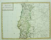
Royaume de Portugal Carte General
by Pierre Francois Tardieu
- Used
- Condition
- Used - Very Good;
- Quantity Available
- 1
- Seller
-
Toronto, Ontario, Canada
- Item Price
-
£222.56
Show Details
Description:
Paris, c. 1750. Very Good;. Notes: Engraved by Pierre Francois Tardieu., Size : 346x462 (mm), 13.62x18.19 (Inches), Coloring: Original Hand Coloring, Category: Maps Europe Portugal;
Item Price
£222.56
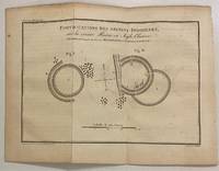
Fortifications Des Anciens Indigenes
by TARDIEU, Pierre Francois
- Used
- Condition
- Used
- Quantity Available
- 1
- Seller
-
New York, New York, United States
- Item Price
-
£238.74
Show Details
Description:
Paris: Maradan, 1801. Print. Uncolored engraving. Plate measures 6" x 8 1/2"<br/><br/> This map and diagram, published in "Voyage dans la Haute Pensylvanie et dans l'etat de New-York" by Michel Crevecoeur, depicts ancient circular fortifications built by Native Americans along the Huron River. The Huron River is also referred to as the Bald Eagle River, named after a large nest found at the mouth of the river in the 18th century. The engraving reads "This sketch was sent to George Washington by A. Steiner on May 28, 1789." Pierre Francois Tardieu (1711-1771) came from a family of engravers and map makers based in Paris. Rare.<br/><br/>
Item Price
£238.74
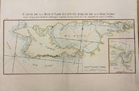
Carte de la Mer D'Azof et d'une Partie de la Mer Noire
by Tardieu, Pierre Francois
- Used
- Condition
- Used - Excellent
- Quantity Available
- 1
- Seller
-
Toronto, Ontario, Canada
- Item Price
-
£364.18
Show Details
Description:
Paris: Le Clerc, Nicolas Gabriel, 1783. Excellent. Size : 238x480 (mm), 9.375x18.875 (Inches), Coloring: Hand Colored, Category: ; Maps Europe Ukraine
Item Price
£364.18
Carte de la Partie Septentrionale des Etats-Unis
by TARDIEU, Pierre Francois
- Used
- Condition
- Used
- Quantity Available
- 1
- Seller
-
New York, New York, United States
- Item Price
-
£465.35
Show Details
Description:
Paris: Maradan, 1801. Map. Uncolored engraving. Image measures 14 1/4" x 19 3/4". Stains and foxing but otherwise in good condition.<br/><br/> Important early map of the United States, published in "Voyage dans la Haute Pensylvanie et dans l'etat de New-York" by Michel Guillame de Crevecoeur. One of the most highly detailed and comprehensive maps published post-Revolution, it depicts the northeast US extending from Maine to northern Virginia, and westward to the Ohio River. In the Finger Lakes region, surveyed bounty land known as the Central New York Military Tract or New Military Tract is indicated. Following the Revolutionary War, New York soldiers were guaranteed 500 acres as compensation for their service. Nearly two million acres were reserved for this purpose. Other interesting features of the map include the Connecticut Western Reserve in present day Ohio, and lack of a northern border in Maine. Cities, counties, rivers, and roadways are labeled. Some…
Read More Item Price
£465.35
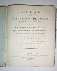
Atlas de tableaux et de cartes gravées par P.F. Tardieu pour le Cours complet de cosmographie de géographie de chronologie et d'histoire ancienne et moderne par Edme Mentelle, membre de l'Institut Nationale Seconde édition. Contemporary edition.
by Tardieu, Pierre-François (cartographer) ; Edme Mentelle (1730 - 1816)
- Used
- Condition
- Used
- Quantity Available
- 1
- Seller
-
San Francisco, California, United States
- Item Price
-
£606.98
Show Details
Description:
Paris, Bernard, 1804,. 4to. 21 x 25.5 cm. With 19 of handcloored double-page maps Lacks the 20th of France but the 2 of America are present...
Contemporary qtr. roan, somewhat worn...
..in-4 relié demi-basane frottée. Illustrées de 6 tableaux dépliants montés sur onglet et de 19 cartes ou plans (sur 20, manque la dernière). Quelques restaurations dans les marges blanches de quelques cartes
Item Price
£606.98

Carte de la Florida et de la Georgia
by TARDIEU, Pierre-Francois
- Used
- Condition
- Used
- Quantity Available
- 1
- Seller
-
New York, New York, United States
- Item Price
-
£971.16
Show Details
Description:
Pierre-Francois Tardieu. unbound. Map. Engraving with modern hand coloring. Image measures 12.5 x 16.75 inches. Sheet measures 17 x 22 inches. In very good condition.<br/> <br/> Beautiful early map of Florida and Georgia, western Louisiana, southern parts of the Carolinas and the Bahamas, circa 1798. The interior of Florida was not yet mapped with distortions to Baie du St. Espirit. Pierre Francois Tardieu (1711-1771) came from a family of engravers and map makers based in Paris. This map was engraved by Jean Emmanuel Jerome Vallet. Hard to find.<br/> <br/>
Item Price
£971.16