Description:
40.1 x 56 cm, original outline hand-colour copper engraving. EXTREMELY RARE map probably from ''Cartes generales de toutes les parties du monde' (?). Condition: with folds as issued, with water stains and professionally repaired tear on lower left margin, not affecting plate. Reference: Quirino, p. 83; BMC Printed Maps XII, col.867; Cat.Nat.mar.Mus.271, map 15; Nordenskiöld 275, vol.1, map 17; pastoureau, Sanson V, map 12.
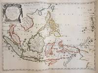
Les Isles Philippines Molucques et de la Sonde by SANSON, Nicolas - 1654
by SANSON, Nicolas
Similar copies are shown below.
Similar copies are shown to the right.

Les Isles Philippines Molucques et de la Sonde
by SANSON, Nicolas
- Used
Paris: Pierre Mariette, 1654. unbound. Map. Engraving with original outline color. Image measures 7.25" x 11.5". Map of the East Indies, centered on the Philippines with Malaysia, Vietnam, Cambodia, and the South China Sea. Cities, mountains and forests are rendered including "Sincapura". It is in good condition with the outer margins trimmed to the plate line. Nicolas Sanson (1600-1667) is considered the founder of the French school of cartography. In reaction to the prevailing trend of Dutch lavishness, Sanson favored minimal details, focusing rather on accurate cartography than ornament. The detail in this map shows the European interest in the Spice trade.
-
Bookseller
Argosy Book Store
 (US)
(US)
- Format/Binding Unbound
- Book Condition Used
- Quantity Available 1
- Publisher Pierre Mariette
- Place of Publication Paris
- Date Published 1654
- Keywords Singapore, Pacific Ocean, Cambodia, South China Sea
We have 1 copies available starting at £688.08.
Les Isles Philippines Molucques et de la Sonde…
by d'Abbeville, Nicolas Sanson / Somer, I
- Used
- Condition
- Used
- Quantity Available
- 1
- Seller
-
Paranaque City, Metro Manila, Philippines
- Item Price
-
£688.08
Show Details
Item Price
£688.08