Description:
Philadelphia, PA: Carey & Lea, 1822. Book. Very good- condition. Unbound. First Edition. 22.25" (width) x 17.5" (height) printed sheet, with 15.5" x 12.25" hand-colored map near center of sheet (four color). Nice condition, except for slight browning to center fold, which is offsetting from original glue from reverse hinge and overall minor browning of paper. An attractive image, suitable for office/library display or gift. Originally bound in an atlas titled "A Complete Historical, Chronological, and Geographical Atlas, Being A Guide to the History of North and South America, and the West Indies: Exhibiting an Accurate Account of the Discovery, Settlement, and Progress of their Various Kingdoms, States, Provinces, &c. Together with Wars, Celebrated Battles, and Remarkable Events, to the Year 1822. According to the Plan of LeSage's Atlas, and Intended as a Companion to Lavoisne's Improvement of that Celebrated Work." Americana..
GEOGRAPHICAL, STATISTICAL, AND HISTORICAL MAP OF VERMONT. by Carey, Henry Charles & Isaac Lea - 1822
by Carey, Henry Charles & Isaac Lea
Similar copies are shown below.
Similar copies are shown to the right.

GEOGRAPHICAL, STATISTICAL, AND HISTORICAL MAP OF VERMONT.
by Carey, Henry Charles & Isaac Lea
- Used
- very good
- Paperback
- first
Philadelphia.: Carey & Lea., 1822. .FULL COLOR.FROM "A COMPLETE HISTORICAL, CHRONOLOGICAL, AND GEOGRAPHICAL AMERICAN ATLAS, Being a Guide To The History Of North and South America, and the West Indies: Exhibiting an Accurate Account of the Discovery, Settlement, and Progress of their Various Kingdoms, States, Provinces, etc. Together with the Wars, Celebrated Battles, and Remarkable Events, To the Year 1822. According to the Plan of Le Sage's Atlas, and Intended as a Companion to LaVoisne's Improvement of that Celebrated Work:.MAP #15.from FIRST EDITION ATLAS.DRAWN BY F. LUCAS.ENGRAVED BY YOUNG & DELLEKER.SHEET MEASURES 22" W x 17" H.COLORFUL MAP IN MIDDLE OF SHEET MEASURES 13" H x 9 3/4" W and is SURROUNDED BY TEXT ON 3 SIDES.Center Fold.EDGES NEAT.MAP CLEAN & BRIGHT.A BEAUTIFUL COPY!.. 1st Edition. Soft Cover. Very Good.
-
Bookseller
Eveleigh Books & Stamps
 (US)
(US)
- Format/Binding Paperback
- Book Condition Used - Very Good
- Edition 1st Edition
- Binding Paperback
- Publisher Carey & Lea.
- Place of Publication Philadelphia.
- Date Published 1822
- Keywords CARTOGRAPHY, MAPS, VERMONT.
We have 7 copies available starting at £141.16.

GEOGRAPHICAL, STATISTICAL, AND HISTORICAL MAP OF THE WEST INDIES.
by Carey, Henry Charles; Isaac Lea
- Used
- Paperback
- first
- Condition
- Used - Very good- condition
- Edition
- First Edition
- Binding
- Paperback
- Quantity Available
- 1
- Seller
-
Chicago, Illinois, United States
- Item Price
-
£141.16
Show Details
Item Price
£141.16
More Photos
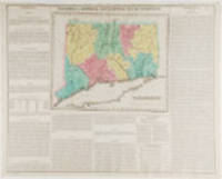
Connecticut. Geographical, Historic and Statistical Map of Connecticut
by CAREY, Henry Charles and Isaac LEA (publishers)
- Used
- Condition
- Used
- Quantity Available
- 1
- Seller
-
New York, New York, United States
- Item Price
-
£161.32
Show Details
Description:
Philadelphia: Carey & Lea, 1823. Engraving with full period colour. Backed on linen. Split at fold expertly repaired. Occasional creases. Fascinating and informative map of Connecticut from one of the most innovative American atlases of the 19th century. Carey & Lea's atlas established a style that was widely admired, especially in Europe: placing a fully coloured map as the centerpiece of the page and surrounding it with geographical and historical facts. The texts were well written and intriguing. The immense transformation of continental America: the vast migration, settlement and industrialization really began at about this time, not long after the War of 1812, when expansion and opportunity were American by-words. It was at this time that American atlases began to need semi-annual revisions because the country had changed so rapidly. In fact, the Carey & Lea gazetteer style, most reminiscent of Herman Moll really, was too time consuming for the firms that published atlases of America as the…
Read More Item Price
£161.32

More Photos
GEOGRAPHICAL, STATISTICAL, AND HISTORICAL MAP OF RHODE ISLAND.
by Carey, Henry Charles; Isaac Lea
- Used
- Paperback
- first
- Condition
- Used - Very good+ condition
- Edition
- First Edition
- Binding
- Paperback
- Quantity Available
- 1
- Seller
-
Chicago, Illinois, United States
- Item Price
-
£241.98
Show Details
Description:
Philadelphia, PA: Carey & Lea, 1822. Book. Very good+ condition. Unbound. First Edition. 22.25" (width) x 17.5" (height) printed sheet, with 8.25" x 11.25" hand-colored map near center of sheet (five color). Excellent condition, except for slight browning to center fold, which is offsetting from original glue from reverse hinge. Minor browning to margins of sheet, easily framed out. An attractive image, suitable for office/library display or gift. Originally bound in an atlas titled "A Complete Historical, Chronological, and Geographical Atlas, Being A Guide to the History of North and South America, and the West Indies: Exhibiting an Accurate Account of the Discovery, Settlement, and Progress of their Various Kingdoms, States, Provinces, &c. Together with Wars, Celebrated Battles, and Remarkable Events, to the Year 1822. According to the Plan of LeSage's Atlas, and Intended as a Companion to Lavoisne's Improvement of that Celebrated Work." Americana..
Item Price
£241.98

More Photos
GEOGRAPHICAL, STATISTICAL, AND HISTORICAL MAP OF NEW HAMPSHIRE.
by Carey, Henry Charles; Isaac Lea
- Used
- Paperback
- first
- Condition
- Used - Very good+ condition
- Edition
- First Edition
- Binding
- Paperback
- Quantity Available
- 1
- Seller
-
Chicago, Illinois, United States
- Item Price
-
£241.98
Show Details
Description:
Philadelphia, PA: Carey & Lea, 1822. Book. Very good+ condition. Unbound. First Edition. 22.25" (width) x 17.5" (height) printed sheet, with 8.75" x 11.75" hand-colored map near center of sheet (five color). Excellent condition, except for slight browning to center fold, which is offsetting from original glue from reverse hinge. Minor browning to margins of sheet, easily framed out. Small tear entering text, not affecting image or presentation. An attractive image, suitable for office/library display or gift. Originally bound in an atlas titled "A Complete Historical, Chronological, and Geographical Atlas, Being A Guide to the History of North and South America, and the West Indies: Exhibiting an Accurate Account of the Discovery, Settlement, and Progress of their Various Kingdoms, States, Provinces, &c. Together with Wars, Celebrated Battles, and Remarkable Events, to the Year 1822. According to the Plan of LeSage's Atlas, and Intended as a Companion to…
Read More Item Price
£241.98

More Photos
GEOGRAPHICAL, STATISTICAL, AND HISTORICAL MAP OF VERMONT.
by Carey, Henry Charles; Isaac Lea
- Used
- Paperback
- first
- Condition
- Used - Very good+ condition
- Edition
- First Edition
- Binding
- Paperback
- Quantity Available
- 1
- Seller
-
Chicago, Illinois, United States
- Item Price
-
£282.31
Show Details
Description:
Philadelphia, PA: Carey & Lea, 1822. Book. Very good+ condition. Unbound. First Edition. 22.25" (width) x 17.5" (height) printed sheet, with 9.25" x 12" hand-colored map near center of sheet (five color). Excellent condition, except for slight browning to center fold, which is offsetting from original glue from reverse hinge. Minor browning to margins of sheet, easily framed out. A few tiny spots of staining to text, not affecting image. An attractive image, suitable for office/library display or gift. Originally bound in an atlas titled "A Complete Historical, Chronological, and Geographical Atlas, Being A Guide to the History of North and South America, and the West Indies: Exhibiting an Accurate Account of the Discovery, Settlement, and Progress of their Various Kingdoms, States, Provinces, &c. Together with Wars, Celebrated Battles, and Remarkable Events, to the Year 1822. According to the Plan of LeSage's Atlas, and Intended as a Companion to Lavoisne's…
Read More Item Price
£282.31
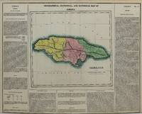
Geographical Statistical and Historical Map of Jamaica.
by Henry Charles Carey; Isaac Lea
- Used
- very good
- Condition
- Used - Very Good
- Quantity Available
- 1
- Seller
-
Toronto, Ontario, Canada
- Item Price
-
£302.47
Show Details
Description:
Philadelphia, c. 1822. Very Good. Notes: Detailed map of Jamaica from Carey & Lea\\\'s Atlas. The map includes a lengthy English description of the agriculture, climate, chief towns, religion commerce, and historical analysis of Jamaica. , Size : 286x311 (mm), 11.25x12.25 (Inches), Coloring: Original Hand Coloring, Category: Maps West Indies Other Islands;
Item Price
£302.47

More Photos
GEOGRAPHICAL, STATISTICAL, AND HISTORICAL MAP OF NEW JERSEY.
by Carey, Henry Charles; Isaac Lea
- Used
- Paperback
- first
- Condition
- Used - Very good+ condition
- Edition
- First Edition
- Binding
- Paperback
- Quantity Available
- 1
- Seller
-
Chicago, Illinois, United States
- Item Price
-
£322.64
Show Details
Description:
Philadelphia, PA: Carey & Lea, 1822. Book. Very good+ condition. Unbound. First Edition. 22.25" (width) x 17.5" (height) printed sheet, with 9.25" x 11.5" hand-colored map near center of sheet (five color). Excellent condition, except for slight browning to center fold, which is offsetting from original glue from reverse hinge. Minor browning to margins of sheet, easily framed out. Two tiny tears at bottom margin not affecting the text or image. An attractive image, suitable for office/library display or gift. Originally bound in an atlas titled "A Complete Historical, Chronological, and Geographical Atlas, Being A Guide to the History of North and South America, and the West Indies: Exhibiting an Accurate Account of the Discovery, Settlement, and Progress of their Various Kingdoms, States, Provinces, &c. Together with Wars, Celebrated Battles, and Remarkable Events, to the Year 1822. According to the Plan of LeSage's Atlas, and Intended as a Companion to…
Read More Item Price
£322.64