Description:
[Boston: B. & J. Loring, 1801. Copper-engraved map, with original outline colour, folded and mounted on linen. Publisher's paper label to verso, in good condition apart from some slight browning. Modern cloth chemise, within a morocco-backed cloth slipcase. A very rare and highly important early map of Massachusetts. The revised and much improved first "official" edition of the most important early map of Massachusetts. In three key ways, this edition is a great improvement over Osgood Carleton's 1798 original which was rejected for official sanction by the government of the Commonwealth. Firstly, the coastline and coastal islands have been more correctly rendered, largely due to the incorporation of information from the charts of Joseph Des Barres. Secondly, roads and streams that had been left incomplete in the earlier map were extended. Thirdly, some of the clutter of the 1798 map, engraved by Carleton's partner, John Norman, was removed, and the map is more attractive and informative, with a…
Read More [COOK] Newton’s new & improved terrestrial pocket globe 1817 by NEWTON FAMILY
by NEWTON FAMILY
![[COOK] Newton�s new & improved terrestrial pocket globe 1817 by NEWTON FAMILY](https://d3525k1ryd2155.cloudfront.net/h/926/764/1547764926.0.m.jpg)
[COOK] Newton’s new & improved terrestrial pocket globe 1817
by NEWTON FAMILY
- Used
London : John Newton, 1st January 1817. Terrestrial pocket globe, 3 inches in diameter, engraved gores with original hand colour over papier-mâché and plaster sphere, the surface in fine order with a recent wax applied for protection, two metal pins resting the globe in the original publisher's shagreen case, titled Newton's improved pocket celestial globe, with engraved diagrams of the constellations, the lips coloured red, original metal hinge and two hook and eye clasps. A fine example of a rare pocket globe, sitting perfectly within its case. A rare and attractive miniature pocket globe showing Cook's third voyage. John Newton (1759-1844) was the founder of a firm of globe makers in London, established in the 1780s and continuing on, with the involvement of Newton's sons, throughout the nineteenth century. This small terrestrial globe in its original case shows the track of Cook's third voyage of 1776-80, with its return to England under the commands of Clerke and Gore. New Holland is shown separated from Van Diemen's Land, Port Jackson and Botany Bay are marked, and interestingly 'French Discoveries' are captioned along the South Australian coastline, a reference to the Baudin expedition. An analemma is drawn over the Pacific Ocean and the 'Antipodes of London' are marked south of New Zealand. References: Dekker, Elly, et al. Globes at Greenwich: A Catalogue of the Globes and Armillary Spheres in the National Maritime Museum, Greenwich. London: Oxford University Press and the National Maritime Museum, 1999, pp. 424 - 425 (GLBO58) Sumira, Sylvia. The art and history of globes. London : The British Library, 2014, p. 189 (the 1831 edition, illustrated).
-
Bookseller
Independent bookstores
 (AU)
(AU)
- Book Condition Used
- Quantity Available 1

More Photos
Map of Massachusetts proper compiled from Actual Surveys made by Order of the General Court, and under the inspection of agents of their appointment
by CARLETON, Osgood (fl.1792-1806)
- Used
- Condition
- Used
- Binding
- Unknown
- Quantity Available
- 1
- Seller
-
New York, New York, United States
- Item Price
-
£14,259.60
Show Details
Item Price
£14,259.60

More Photos
Historia de Gentibus septentrionalibus, earumqve diversis statibus, conditionibus, moribus, ritibus, superstitionibus, disciplinis, excercitiis, regimine, victu, belleis, structuris, instrumentis, ac mineris metallicis, & rebus mirabilibus, necnon uni... - [THE LARGE COMMENTARY TO "CARTA MARINA"]
by MAGNUS, OLAUS.
- Used
- Hardcover
- first
- Condition
- Used
- Binding
- Hardcover
- Quantity Available
- 1
- Seller
-
Copenhagen, Denmark
- Item Price
-
£13,121.50
Show Details
Description:
1555. Romae, (Colophon: Apud Ioannem Mariam de Viottis Parmensem, in aedibus Birgitttae), 1555. Folio. Bound to style in later (around 1950) full vellum with 4 raised bands to spine. Endpapers renewed. Old owners name on foot of titlepage. 42 unnumb. leaves + 815 pp. (p. 815 is the full page woodengraved printers device, verso blank). With 472 fine woodcuts in the text, the greatest part measuring 59x93 mm, a few half-page and some 1/3-page, among these the full-page map over Scandinavia (the smaller sized "Carta Marina"). Only few scattered brownspots, probably lightly washed by the rebinding. From ab. p. 500 the upper margins have some faint dampspots, which on ab. 25 leaves has left some small loss of paper, and on a few places the loss of a letter in the caption title, but everywhere professionally repaired with paperpulp where needed. First edition of Magnus' great work, which constitutes the first larger geographical-ethnographical description of Scandinavia and one of the most important…
Read More Item Price
£13,121.50

More Photos
L’Utrecht suivant les nouvelles observations de Messrs. de l’Academie des Sciences etc. Augmentées de nouveau.
by Covens, Johannes et Cornelis Mortier
- Used
- Condition
- Used
- Quantity Available
- 1
- Seller
-
Tuebingen, Germany
- Item Price
-
£1,937.92
Show Details
Description:
Engraved and partially hand-coloured map with nice figurative cartouche mounted on wood, backside lined with blue paste paper with impressed decoration (= complete). Oblong folio (300 x 223 mm). All pieces loosely contained in contemporary wooden box with a sliding lid with manuscript title "Utrecht" on top. A very early example of this kind of game, and hard to find complete and in very good overall condition.
Item Price
£1,937.92
More Photos
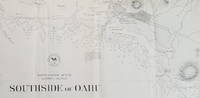
Southside of Oahu.
by [Hawaii: Oahu.] U.S. Navy.
- Used
- Condition
- Used
- Quantity Available
- 1
- Seller
-
Scarborough, Maine, United States
- Item Price
-
£594.15
Show Details
Description:
Scarce Chart of Oahu: Pearl Harbor to Diamond HeadThis is a wonderfully detailed chart of the Pearl Harbor/Honolulu area. It names Diamond Head, Waikiki, Honolulu (with street grid shown), and Pearl Lochs (later, Pearl Harbor) and locates numerous landmarks: school, windmill, leper asylum, prison and several areas with heavy surf and breakers.
The chart appears to be directly derived from a larger, separately issued chart of the same title that covered a somewhat larger area (Hydrographic Office Chart no. 867). The larger chart was first issued in 1880 and updated at least through 1901. While a very short segment of Oahu R.R. is shown just west of Honolulu on the present chart, the much longer stretch of the railway that looped around the northern portion of Pearl Lochs is not shown here as it is on the 1899 edition of the larger map. Since the main portion of the Oahu Railway was completed in late 1889, it suggests that the present map was completed prior to that date. We have been unable to… Read More
Item Price
£594.15
![MAP OF UTAH [Territory]](https://d3525k1ryd2155.cloudfront.net/h/836/461/1485461836.0.m.jpg)
More Photos
MAP OF UTAH [Territory]
- Used
- Condition
- Used - Very Good-
- Edition
- Original
- Quantity Available
- 1
- Seller
-
Williamsburg, Virginia, United States
- Item Price
-
£51.49
Show Details
Description:
New York, Richmond, Chicago, & Toledo: H. H. Hardesty, 1885. Original color lithographed map printed by Rand, McNally & Company, Engravers and published in HARDESTY'S HISTORICAL AND GEOGRAPHICAL ENCYCLOPEDIA: SPECIAL VIRGINIA EDITION. 19 3/8 inches by 13 1/4 inches on a 21" X 14 1/2" sheet. The map depicts the Territory of Utah in its final form--large areas had been removed and ceded to Nevada, Colorado, Wyoming, and Nebraska since Utah became a U. S. Territory in 1850. The issue of polygamy prevented statehood until it was finally granted in 1896. This map features railroads and topography and uses color to set off counties from each other. Unlike most atlas maps of the period, this map identifies most small towns. The map is guaranteed to be moe than 135 years old. The map is in about very good condition: generally clean and bright, with slight toning of paper and one faint water stain near the center-left edge of the map.. Original. Single Sheet. Very Good-. Elephant…
Read More Item Price
£51.49
More Photos
Map of Massachusetts proper compiled from Actual Surveys made by Order of the General Court, and under the inspection of agents of their appointment
by CARLETON, Osgood (fl.1792-1806)
- Used
- Condition
- Used
- Binding
- Unknown
- Quantity Available
- 1
- Seller
-
New York, New York, United States
- Item Price
-
£14,259.60
Show Details
Description:
[Boston: B. & J. Loring, 1801. Copper-engraved map, with original outline colour, folded and mounted on linen. Publisher's paper label to verso, in good condition apart from some slight browning. Modern cloth chemise, within a morocco-backed cloth slipcase. A very rare and highly important early map of Massachusetts. The revised and much improved first "official" edition of the most important early map of Massachusetts. In three key ways, this edition is a great improvement over Osgood Carleton's 1798 original which was rejected for official sanction by the government of the Commonwealth. Firstly, the coastline and coastal islands have been more correctly rendered, largely due to the incorporation of information from the charts of Joseph Des Barres. Secondly, roads and streams that had been left incomplete in the earlier map were extended. Thirdly, some of the clutter of the 1798 map, engraved by Carleton's partner, John Norman, was removed, and the map is more attractive and informative, with a…
Read More Item Price
£14,259.60
![Blatt 8 (VIII) : Aarau - Luzern Zug - Zürich [Zurich] : Topographische Karte der Schweiz :...](https://d3525k1ryd2155.cloudfront.net/h/777/796/330796777.0.m.jpg)
More Photos
Blatt 8 (VIII) : Aarau - Luzern Zug - Zürich [Zurich] : Topographische Karte der Schweiz : Massstab 1 : 100,000, Vermessen und herausgegeben unter Aufsicht von General G. H. Dufour
by Dufour, General G. H. [Guillaume-Henri]
- Used
- Hardcover
- Condition
- Used - Very Good (somewhat spotted)
- Edition
- 1861 edition
- Binding
- Hardcover
- Quantity Available
- 1
- Seller
-
Henderson, Nevada, United States
- Item Price
-
£138.64
Show Details
Description:
Bern [Switzerland]: Hans Körber [Koerber] (Huber & Comp.), 1861. Very Good condition. SEE PHOTOS. Karten etwas fleckig (maps somewhat spotted). This is Blatt VIII, Aarau - Luzern Zug - Zürich [Zurich]. The map is dated 1861 and has 21 sections. It is printed on paper, then mounted on cloth (i.e. backed with linen). When folded the map measures 19 cm tall x 11 cm wide. When unfolded, 57 cm tall x 79 cm wide. SEE PHOTOS. Linen-backed, steel-engraved folding map in 21 segments. Scale 1:100,000.. 1861 edition. Hardcover. Very Good (somewhat spotted).
Item Price
£138.64
More Photos
Historia de Gentibus septentrionalibus, earumqve diversis statibus, conditionibus, moribus, ritibus, superstitionibus, disciplinis, excercitiis, regimine, victu, belleis, structuris, instrumentis, ac mineris metallicis, & rebus mirabilibus, necnon uni... - [THE LARGE COMMENTARY TO "CARTA MARINA"]
by MAGNUS, OLAUS.
- Used
- Hardcover
- first
- Condition
- Used
- Binding
- Hardcover
- Quantity Available
- 1
- Seller
-
Copenhagen, Denmark
- Item Price
-
£13,121.50
Show Details
Description:
1555. Romae, (Colophon: Apud Ioannem Mariam de Viottis Parmensem, in aedibus Birgitttae), 1555. Folio. Bound to style in later (around 1950) full vellum with 4 raised bands to spine. Endpapers renewed. Old owners name on foot of titlepage. 42 unnumb. leaves + 815 pp. (p. 815 is the full page woodengraved printers device, verso blank). With 472 fine woodcuts in the text, the greatest part measuring 59x93 mm, a few half-page and some 1/3-page, among these the full-page map over Scandinavia (the smaller sized "Carta Marina"). Only few scattered brownspots, probably lightly washed by the rebinding. From ab. p. 500 the upper margins have some faint dampspots, which on ab. 25 leaves has left some small loss of paper, and on a few places the loss of a letter in the caption title, but everywhere professionally repaired with paperpulp where needed. First edition of Magnus' great work, which constitutes the first larger geographical-ethnographical description of Scandinavia and one of the most important…
Read More Item Price
£13,121.50
A PROSPECT OF THE TOWN AND HARBOUR OF TRIPOLI IN SYRIA (LEBANON)
by TRIPOLI - LEBANON - Original Antique Etching
- Used
- Very Good
- first
- Condition
- Used - Very Good
- Edition
- First English Edition
- Binding
- Unknown
- Quantity Available
- 1
- Seller
-
Tel-Aviv, Israel
- Item Price
-
£142.60
Show Details
Description:
1730. First English Edition . No Binding. Very Good. I.B.Martin. ORIGINAL ANTIQUE ETCHING (copper plate) dated 1730, of Tripoli in Lebanon, as seen from the sea. Drawn by I.B.Martin in 1729 (date appears at the right bottom). Nr. 1 on the map indicates the CASTLE (site of former Crusaders' CITADEL of RAYMOND DE SAINT GILLES, also known as Qala'at Sanjil and Qala'at Tarablus ).- Very good impression. Original centerfold. Size of image in cm 43,8 x 27,5 (inch 17,1 x 10,3) . Whole leaf: 46,5 x 39cm (18,3" x 15,3"). Untrimmed large margins. Very few tiny ageing stains at center bottom of outer margins. VERY GOOD AND FRESH CONDITION. (ANCIENT CITY TOPOGRAPHY TARABULUS ASH-SHAM PHOENICIA)
Item Price
£142.60

More Photos
Twelve Manuscript Maps of the Ancient World.
by TATHAM, Sherman Ralph
- Used
- Hardcover
- Condition
- Used
- Binding
- Hardcover
- Quantity Available
- 1
- Seller
-
Richelieu, France
- Item Price
-
£450.00
Show Details
Description:
1865. Twelve manuscript maps with dated inscription: "A.M. Tatham from her afft. Bro Sherman Dec. 1865". Rebound from a broken binding as a folding leporello series of maps in cloth covered boards "Bible Atlas S.R.T." on original label to the front. Binding is new and without flaws. Slight scratch to blank (back) of first map, otherwise the maps are in excellent condition. The maps comprise: The Nations of the Ancient World, Assyria and the Adjacent Lands, Canaan in Patriarchal Ages, Canaan as Divided among The Tribes, Dominions of David and Solomon, Armenia, Egypt and Sinai Peninsula Illustrating the Journey of the Israelites to the Promised Land, Jerusalem and its Environs, The Kingdoms of Judah & Israel, Palestine in the time of Our Saviour, Modern Palestine, and The Eastern Mediterranean Illustrating the Travels of St. Paul. Each map folds out to approx. 165 x 133 mm. The maps still retain their original bright colouring. Sherman Ralph Tatham was born in Hampstead in 1850. Educated at…
Read More Item Price
£450.00

More Photos
The Sky and the Forest
by Forester, C.S
- Used
- Very Good
- Hardcover
- first
- Condition
- Used - Very Good
- Jacket Condition
- Very Good
- Edition
- First Edition
- Binding
- Hardcover
- Quantity Available
- 1
- Seller
-
Salem, Oregon, United States
- Item Price
-
£27.64£13.82Save £17.44!
Show Details
Description:
C.S. Forester: The Sky and the Forest. Little, Brown and Company, Boston. Stated First Edition First Printing Thus August, 1948. Cover price $2.75. Used. VG BOOK/VG UNCLIPPED DUST JACKET. A story of a central Africa. By C.S. Forester, author of the Admiral Hornblower series.
Item Price
£27.64£13.82
Save £17.44
!

More Photos
Old Decorative Maps and Charts
by Humphreys, Arthur L
- Used
- Very Good
- Hardcover
- first
- Condition
- Used - Very Good
- Jacket Condition
- No Jacket
- Edition
- First Edition
- Binding
- Hardcover
- Quantity Available
- 1
- Seller
-
Sumner, Iowa, United States
- Item Price
-
£35.65
Show Details
Description:
London: London: Halton & Truscott Smith, LTD>. Limited Edition of 1500 copies of which this is number No. 906---Clean, no marks, pages pristine. 79 maps dated 1482-1776 from engravings in the MacPherson Collection. Top Edge Gilt--No DJ Covers rubbed and very slight lean to spine----interior in excellent condition. . Very Good. Hardcover. First Edition. 1926.
Item Price
£35.65

More Photos
Plat Book: Pierce County, Wisconsin
by Rhame, A. E
- Used
- Fine
- Paperback
- Condition
- Used - Fine
- Binding
- Paperback
- Quantity Available
- 1
- Seller
-
Woodruff, Wisconsin, United States
- Item Price
-
£36.96
Show Details
Description:
1930. Soft Cover. Fine. Unpaginated. Tan colored book is in Fine condition, no sign of wear.
Item Price
£36.96
![Alaska and Klondike Region; [With inset of Klondike Region on the Upper Yukon detail] [From an...](https://d3525k1ryd2155.cloudfront.net/h/062/537/1339537062.0.m.jpg)
Alaska and Klondike Region; [With inset of Klondike Region on the Upper Yukon detail] [From an atlas, "Gazetteer of Alaska and Yukon Region " pp. 105 and 106]
by Miller, J. Martin
- Used
- Very Good
- Condition
- Used - Very Good
- Edition
- Unknown
- Quantity Available
- 1
- Seller
-
Sebastopol, California, United States
- Item Price
-
£30.90
Show Details
Description:
Chicago: J. Martin Miller, 1899. Unknown. Map. Very Good. [Map copyright 1899, printing date of Atlas later] [19.875x15.125in]; Colored map of Alaska with steamer routes from Portland and Seattle, insets of the Klondike Region on the Upper Yukon and Western portion of Aleutian Islands; On verso index of places and names with two large black and white images; Age toning to all edges, water stain marks on bottom, slight printing offset of colors, small chips and closed tears to lower edge;.
Item Price
£30.90

Last Tales
by Dinesen, Isak
- Used
- Very Good
- Hardcover
- first
- Condition
- Used - Very Good
- Jacket Condition
- Good+
- Edition
- First Edition
- Binding
- Hardcover
- Quantity Available
- 1
- Seller
-
Salem, Oregon, United States
- Item Price
-
£95.06£47.53Save £60.00!
Show Details
Description:
Dinesen, Isak: Last Tales, A Collection of Twelve New Tales of Compelling Beauty 1957, Random House. First Edition. Stated First Printing Thus. Used. Very Good/Good+ original red dust jacket, price-clipped. Jacket states 11/57 on front flap. 5 3/4 X
Item Price
£95.06£47.53
Save £60.00
!

Zemepis Sveta - Monsunova Asie
by De La Blache, P. Vidal; Gallois, L
- Used
- Hardcover
- Condition
- Used - Very Good Condition
- Jacket Condition
- No Dust Jacket
- Binding
- Hardcover
- Quantity Available
- 1
- Seller
-
Oak Point, Texas, United States
- Item Price
-
£47.53
Show Details
Description:
Aventinum, Prague, Czechoslovakia, 1931. Hardcover. Very Good Condition/No Dust Jacket. Text entirely in Czech. Geography book on Asia with numerous photographs and maps. 1930 edition also available. Size: 4mo - over 9 3/4" - 12" tall. 400 pp. Pages are yellowed, but are tight and clean. Moderate shelfwear along the spine. Corners are lightly bumped. Quantity Available: 1. Shipped Weight: 3-5 pounds. Category: Travel & Places; Non-English Language::Czech; Pictures of this item not already displayed here available upon request. Inventory No: 001228. . Additional shipping charges may apply.
Item Price
£47.53

Zemepis Sveta - Monsunova Asie
by De La Blache, P. Vidal; Gallois, L
- Used
- Hardcover
- Condition
- Used - Very Good Condition
- Jacket Condition
- No Dust Jacket
- Binding
- Hardcover
- Quantity Available
- 1
- Seller
-
Oak Point, Texas, United States
- Item Price
-
£47.53
Show Details
Description:
Aventinum, Prague, Czechoslovakia, 1930. Hardcover. Very Good Condition/No Dust Jacket. Text entirely in Czech. Geography book on Asia with numerous photographs and maps. 1931 edition also available. Size: 4mo - over 9 3/4" - 12" tall. 400 pp. Pages are yellowed, but are tight and clean. Moderate shelfwear along the spine. Corners are lightly bumped. Quantity Available: 1. Shipped Weight: 3-5 pounds. Category: Travel & Places; Non-English Language::Czech; Pictures of this item not already displayed here available upon request. Inventory No: 001227. . Additional shipping charges may apply.
Item Price
£47.53

The Adventure of Wrangel Island
by Vilhjalmur Stefansson
- Used
- Good
- Hardcover
- first
- Condition
- Used - Good
- Jacket Condition
- No DJ Included
- Edition
- First Edition
- Binding
- Hardcover
- Quantity Available
- 1
- Seller
-
Salem, Oregon, United States
- Item Price
-
£98.94£49.47Save £62.44!
Show Details
Description:
The Adventure of Wrangel Island, Alaska (1925 Macmillan 1st Edition) HISTORY OF ALASKA. EXLIB. Good Condition/ No DJ included. Fold-out map affixed to binding at the back of the book has never been opened. The story of the (unsuccessful) attempted colonization of Wrangel Island Alaska. 413 pages plus appendix, Index. Titling is still bright. A clean, solid copy. Scarce.
Item Price
£98.94£49.47
Save £62.44
!

Seven Pillars Of Wisdom, A Triumph
by Lawrence, T.E
- Used
- Good
- Hardcover
- first
- Condition
- Used - Good
- Jacket Condition
- No DJ Included
- Edition
- First American Edition
- Binding
- Hardcover
- Quantity Available
- 1
- Seller
-
Salem, Oregon, United States
- Item Price
-
£98.99£49.50Save £62.47!
Show Details
Description:
T.E. Lawrence. SEVEN PILLARS OF WISDOM, A TRIUMPH. AUTOBIOGRAPHY. Privately Printed, 1926. First Published for general circulation 1935. First American Edition. States MCMXXXVI on the title page. Doubleday, Doran & Company, Inc. Garden City, NY. GOOD CONDITION/ NO DUST JACKET IS INCLUDED. 672 pages, indexed. Beige buckram boards. Spine has darkened a bit. 6 7/8 X 9 ½.
Item Price
£98.99£49.50
Save £62.47
!

North America from the Best Authorities, Russell, ca.1800
by Russell
- Used
- Condition
- Used
- Quantity Available
- 1
- Seller
-
Plymouth, Devon, United Kingdom
- Item Price
-
£20.00
Show Details
Description:
Russell, J. : A General Map of North America from the Best Authorities. Nd but ca.1800. From "A New Geographical, Historical and Commercial Grammar and Present State of Several Kingdoms of the World." Copper engraving. Size approx 200 x 230mm. Two neat folds. Some age colouring to edges, otherwise very clean and bright.
Item Price
£20.00
