
Click for full-size.
Carte De La Louisiane…
by Bellin, Jacques Nicholas
- Used
- Condition
- See description
- Seller
-
Florham Park, New Jersey, United States
Payment Methods Accepted
About This Item
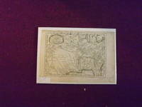
Small engraved map, 30.5 x 22.4 cm (9 " x 12" excluding margins), uncolored, small decorative cartouche. Some aging and browning, some creases at folds, small tear in lower margin, impression bright and clean; very good or better. Bellin (1703-1772) born in Paris and according to Tooley was considered one of the most prominent cartographers of the 18th century in a career that lasted about 50 years. This is a colonial period map that was made after Delisle's map of the Mississippi and Louisiana. There is considerable detail, and the map shows the Louisiana Territory extending from the Great Lakes to the Gulf of Mexico. The map also shows part of Northern Florida, Georgia, the Carolinas, and even part of Texas. Some Indian territories, including the Apaches are shown along with some European settlements. Tooley: The Mapping of America.
Details
- Bookseller
- Nicholas D. Riccio Rare Books & Prints
 (US)
(US)
- Bookseller's Inventory #
- 106070
- Title
- Carte De La Louisiane…
- Author
- Bellin, Jacques Nicholas
- Book Condition
- Used
- Quantity Available
- 1
- Place of Publication
- [Paris]:
- Date Published
- 1757.
- Keywords
- Map of Louisiana. Early Maps.
Terms of Sale
Nicholas D. Riccio Rare Books & Prints
30 day return guarantee, with full refund including shipping costs for up to 30 days after delivery if an item arrives misdescribed or damaged.
About the Seller
Nicholas D. Riccio Rare Books & Prints
Biblio member since 2011
Florham Park, New Jersey
About Nicholas D. Riccio Rare Books & Prints
Established in 1999 we specialize in Americana, African Americana, Natural History, Travel & Exploration, Science & Medicine, and Maps & Atlases
Glossary
Some terminology that may be used in this description includes:

Storing books - laying down or standing up?
Don’t unwittingly damage your growing book collection! Learn about when to store books laying down vs standing up. Read About Safe Book Storage

Beat Poet Michael McClure
From the fateful reading at Six-Gallery in 1955 to his novels, poetry, and stage productions, Michael McClure was right in the thick of the Beat Generation as it was born. See his books and art and learn more about the works of Michael McClure.