Description:
Washington: Robert Armstrong Public Printer, 1853., 1853. First edition. Senate edition, Executive Document No. 3, Special Session, March, 1851. 2 volumes. Cloth, 495 pp. + 2 large folding maps in separate portfolio volume. 58 plates, including folding panoramic views. Many appendices, charts, tables, index. This is the first extensive survey of the Great Basin, and a major landmark in the cartography of the American West. "Captain Stansbury, commanded the detachment of the Army's topographical engineers which was directed in 1849 to explore and report on the Great Salt Lake Basin. Of particular interest were the newly established Mormon settlements, and the routes and passes through the Rockies for emigrants and possibly a railroad."---Wagner-Camp 219:1. In Mapping The Transmississippi West, Vol.3, pp.117-127, Carl Wheat describes the explorations of Stansbury and Lt. John Gunnison, and the important maps issued with this work as created by Stansbury; Gunnison; famous cartographer,…
Read More EXPLORATION AND SURVEY OF THE VALLEY OF THE GREAT SALT LAKE CITY OF UTAH, INCLUDING A RECONNOISSANCE OF A NEW ROUTE THROUGH THE ROCKY MOUNTAINS; (SENATE Special Session March 1851; Executive, No. 3) Printed by Order of House of Representatives of The United States) by Stansbury, Howard (Captain Corps Topographical Engineers, U.S. Army) - 1853
by Stansbury, Howard (Captain Corps Topographical Engineers, U.S. Army)
Similar copies are shown below.
Similar copies are shown to the right.
EXPLORATION AND SURVEY OF THE VALLEY OF THE GREAT SALT LAKE CITY OF UTAH, INCLUDING A RECONNOISSANCE OF A NEW ROUTE THROUGH THE ROCKY MOUNTAINS; (SENATE Special Session March 1851; Executive, No. 3) Printed by Order of House of Representatives of The United States)
by Stansbury, Howard (Captain Corps Topographical Engineers, U.S. Army)
- Used
- Good
- Hardcover
- first
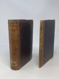
Washington DC: Robert Armstrong, Public Printer, 1853. First Edition. Hardcover. Good. Quarto. 9 in. x 6 in., pp. 495. Maroon stamped cloth boards, ruled in blind. Gilt lettering to spine, as well as graphic in gilt of a buffalo. Bumped corners, Stained endpapers with some penciled writing. Frontis lithograph. All plates as called for, though several out of order. 58 lithographed illustrations. NOTE: Several plates facsimiles. Moderate foxing (light spotting) throughout.
Two Maps (both originals) accompanying Stansbury's report, were originally issued as folded in a separate hardcover binding, but for protection and close study, the folding maps have been removed, and safely stored in a clear, archival display sleeve. [Maps will be mailed under separate cover in a mail-tube.]
The first map is entitled "Map of a Reconnaissance between Fort Leavenworth on the Missouri River and the Great Salt Lake in the Territory of Utah, made in 1849 and 1850 under the orders of Col. J.J. Abert, Chief of the Topographical Bureau, by Capt. Howartd Stansbury of the Corps of Topographical Engineers, aided by Lieut. J.W. Gunnison Corpos Topographical Engineers, and Albert Carrington. The adjacent country laid down from the latest and most authentic data. Drawn by Lieut. Gunnison and Charles Preuss." (Wheat, Mapping the Transmississippi West).
The second accompanying map is titled "Map of the Great Salt Lake and Adjacent Country in the Territory of Utah, Surveyed in 1849 and 1850...by Capt. Howard Stansbury of the Corps of Topographical Engineers and Albert Carrington. Drawn by Lieut. Gunnison and Charles Preuss." "Captain Howard Stansbury, in 1849, had taken a topographical party west to make a thorough examination of the Great Salt Lake country, and the routes from it...He was accompanied by Lieutenant John Williams Gunnison, and they set out together from Fort Leavenworth on May 31, 1849, traveling near the tail-end of the California emigration. Both officers kept journals of the march, on which Stansbury also subsequently submitted an official report."
-
Bookseller
Aardvark Rare Books
 (US)
(US)
- Format/Binding Hardcover
- Book Condition Used - Good
- Quantity Available 1
- Edition First Edition
- Binding Hardcover
- Publisher Robert Armstrong, Public Printer
- Place of Publication Washington DC
- Date Published 1853
- Keywords Utah history; Mormon History; "Spiritual Marriage" -- Mormons; Plural Wives; Zamorano 80;
We have 1 copies available starting at £1,093.95.

EXPLORATION AND SURVEY OF THE VALLEY OF THE GREAT SALT LAKE OF UTAH, INCLUDING A RECONNAISSANCE OF A NEW ROUTE THROUGH THE ROCKY MOUNTAINS
by STANSBURY, CAPT. HOWARD
- Used
- Hardcover
- first
- Condition
- Used
- Edition
- First edition
- Binding
- Hardcover
- Quantity Available
- 1
- Seller
-
Greencastle, Pennsylvania, United States
- Item Price
-
£1,093.95
Show Details
Item Price
£1,093.95