Description:
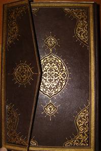
Uskudar: MuhendisHane-i Berr-i Humatun (The Royal school of military engneering) Atlas. Illus. by YUMNI. Very Good. Hardcover. Folio - over 12" - 15" tall. 1860's THIRTY NINE HAND COLORED MAPS MOSTLY SIGNED BY (YUMNI). MOST OF THEM ARE DESCRIBED IN THE OTTOMAN TURKISH. ALL MAPS ON DOUBLE PAGES, TITLED AND WITH PRINTING DETAILS. LATER HARD COVER. FOLIO 40 X 28 CM. SCARCE. the maps are the followings: (1)Arabistan (Arabian peninsula) 56 x 47 cm. (2)Tarablus Gharb wa tunus (Libya and Tunisia) 56 x 39 cm. (3)Tarablus Gharb (Libya) 56 x 40 cm. (4)Misir ayalet I mumtaza si (territory of Egypt) 56 x 46 cm. (5)Yemen 69 x 33 cm. (6)Hejaz, 56 x 39 cm. (7)Ankara . (8)Sivas . (9)Ma'muat ul Aziz. (10)Diyar Bekir. (11)Bitlis. (12)Erzurum . (13)Van. (14)Mosul 56 x 39 cm. (15)Bagdad 56 x 39 cm. (16)Basra 55 x 39 cm. (17)Zor mutasarrifligi (Part of Mesopotamia. (18)Halep (Aleppo). (19)Adana. (20)Konya. (21)Kibris (Cyprus). (22)Caza'ir I Bahr I Sefid (the Wilaya of the Mediterranean sea islands). (23)Aydin. (24)Pega…
Read More cihannuma (mirror of the world) complete copy with all of the maps, contemporary hand-colored by KATIB CELEBI (Mustafa ibn Abd Allah, aka Haci Halife, 1609-1657) - 1732
by KATIB CELEBI (Mustafa ibn Abd Allah, aka Haci Halife, 1609-1657)
cihannuma (mirror of the world) complete copy with all of the maps, contemporary hand-colored
by KATIB CELEBI (Mustafa ibn Abd Allah, aka Haci Halife, 1609-1657)
- Used
- very good
- Hardcover
- first
with 40 contemporary hand-colored maps complete. corners of the first 4p. repaired with missing of few words from the preface. otherwise, fine copy in modern fine Ottoman style binding lavishly gilt in gold. FIRST AND ONLY EDITION OF THE JIHANNUMA. Planned as a great cosmosgraphy, the work was never completed, although Katib Celebi wrote two versions. The text contained here is the second version, rewritten after the author had acquired a Mercator-Hondius Atlas minor (Koemans mistakenly considered the Jihannuma a translation into Turkish of that Atlas). It covers the world from Japan to the Ottoman borders and is well-illustrated with engraved maps, including: the World in twin hemispheres, the World in oval projection, Europe, Africa, Asia, America, the North and South Poles, Arabia, Japan and various other parts of Asia and Asia Minor. Several of the maps and diagrams had appeared in earlier books printed by Mteferrika.
The author, born Mustafa ibn Abd Allah at Constantinople in 1609, was a prolific scholar, historian, geographer, and bibliophile. Another of his works, Tuhfet l-Kibar fi esfar il bihar was published only 4 years earlier at the same press, and was the first geographical work to be printed in Turkey. Mteferrika added to the Jihannuma a section concerning the ideas of Copernicus and Tycho Brahe. Koemans II, 549 cites 37 plates; Toderini p.114ff. cites 39; and copies are known with 41. (Christies note).
-
Bookseller
Archive
 (SA)
(SA)
- Format/Binding Full leather
- Book Condition Used - Very Good
- Quantity Available 1
- Edition first ed.
- Binding Hardcover
- Publisher Ibrahim Muteferrika
- Date Published 1732
- Size Quarto
- Keywords muteferrika; mutafarrika; ibrahim; maps; atlas; cihannuma; jihannuma; 1145; 1732; constantinople;
- Size Quarto
More Photos
OTTOMAN ATLAS CONTAINS THIRTY NINE HAND COLORED MAPS PREPARED AND PRINTED IN THE MUHENDISHANE I BERRI HUMAYUN (THE ROYAL SCHOOL OF MILITARY ENGNEERING) IN ISTANBUL. POSSIBLY THE FIRST ADMINISTRATIVE ATLAS TO BE PRINTED IN USKUDAR AFTER THE ESTABLISHMENT OF THE TELEGRAPH LINES IN THE OTTOMAN WILAYAS (STATES)
by THE OTTOMAN AUTHORITY
- Used
- very good
- Hardcover
- Signed
- Condition
- Used - Very Good
- Binding
- Hardcover
- Quantity Available
- 1
- Seller
-
Riyadh, Saudi Arabia
- Item Price
-
£40,695.00
Show Details
Item Price
£40,695.00
More Photos
RARE OTTOMAN MILITARY MAP OF KARA DAG (MONT NEGRO)
by Ottoman General Staff Section
- Used
- very good
- Condition
- Used - Very Good
- Quantity Available
- 1
- Seller
-
Riyadh, Saudi Arabia
- Item Price
-
£4,069.50
Show Details
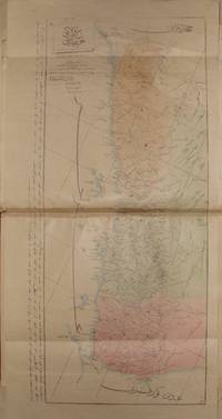
Description:
Istanbul: The general staff section, 1875 Map. Very Good. No Binding. Military map of Kara Dag (Mont Negro), Ottoman General staff section in 1291 (1875) after the map which made by the Austrian military geographical section in 1869 about Kara Dag and environs after the war and military movements of 1861-1862. Officially linen in colors by contemporary hands, 105 x 105 cm. Very rare..
Item Price
£4,069.50
More Photos
Tuhfet ul Kibar fi Esfar il Bihar, complete with the all maps contemporarly hand colored
by katib Celebi, Haci Halife
- Used
- Condition
- Used - Very Good+
- Quantity Available
- 1
- Seller
-
Riyadh, Saudi Arabia
- Item Price
-
£48,834.00
Show Details
Description:
complete fine copy with the 5 maps of which 4 are colored in contemporary hands.In modern fine Ottoman style binding. on The naval expeditions, printed by Ibrahim Muteferrika in 1141 H. (1728-1729).
Item Price
£48,834.00

More Photos
Avrupa-i Osmani Haritasi (Wall map of the Ottoman Europe), extra ordinary copy of an Ottoman lieutenant
- Used
- very good
- Condition
- Used - Very Good
- Quantity Available
- 1
- Seller
-
Riyadh, Saudi Arabia
- Item Price
-
£5,697.30
Show Details
Description:
205 x 137 cm. extra ordinary Ottoman wall map of the Ottoman Europe prınted ın colors, folding paper on cloth. Signatures by the first lieutenant M. İhsan.
Item Price
£5,697.30

More Photos
SMITH'S MAP OF PHILADELPHIA AND VICINITY
by Gannett, Henry; Chief Topographer, U. S. Geological Survey
- Used
- Hardcover
- first
- Condition
- Used - Good+
- Edition
- First Edition Thus; Second Printing
- Binding
- Hardcover
- Quantity Available
- 1
- Seller
-
Fairfield, New Jersey, United States
- Item Price
-
£142.43
Show Details
Description:
Philadelphia: J. L. Smith. Good+. 1904. First Edition Thus; Second Printing. Hardcover. U. S. Geological Survey, surveyed in 1894, edition of 1902, printed in 1904. This is a 30 1/2" x 38 1/2" USGS map that J. L. Smith of Philadelphia, sometime after issue, sectioned (4 sections x 6 sections) and mounted on linen to create a folding pocket map. It is mounted in a 10 x 5.5 inch dark brown embossed and gilded hardcover folder that bears the title "Smith's Map of Philadelphia and Vicinity". The map covers the area north and west well past Norristown and south into Delaware, as well as a good part of New Jersey beyond Camden. It shows the local road network and was made for local travel. The inside cover has original owner's signature. Cover graded G+ due to rubbing along the spine edges & corners. The map is in VG condition. ; Fold out cloth Map; Small 4to 9" - 11" tall .
Item Price
£142.43
More Photos
OTTOMAN ATLAS CONTAINS THIRTY NINE HAND COLORED MAPS PREPARED AND PRINTED IN THE MUHENDISHANE I BERRI HUMAYUN (THE ROYAL SCHOOL OF MILITARY ENGNEERING) IN ISTANBUL. POSSIBLY THE FIRST ADMINISTRATIVE ATLAS TO BE PRINTED IN USKUDAR AFTER THE ESTABLISHMENT OF THE TELEGRAPH LINES IN THE OTTOMAN WILAYAS (STATES)
by THE OTTOMAN AUTHORITY
- Used
- very good
- Hardcover
- Signed
- Condition
- Used - Very Good
- Binding
- Hardcover
- Quantity Available
- 1
- Seller
-
Riyadh, Saudi Arabia
- Item Price
-
£40,695.00
Show Details
Description:
Uskudar: MuhendisHane-i Berr-i Humatun (The Royal school of military engneering) Atlas. Illus. by YUMNI. Very Good. Hardcover. Folio - over 12" - 15" tall. 1860's THIRTY NINE HAND COLORED MAPS MOSTLY SIGNED BY (YUMNI). MOST OF THEM ARE DESCRIBED IN THE OTTOMAN TURKISH. ALL MAPS ON DOUBLE PAGES, TITLED AND WITH PRINTING DETAILS. LATER HARD COVER. FOLIO 40 X 28 CM. SCARCE. the maps are the followings: (1)Arabistan (Arabian peninsula) 56 x 47 cm. (2)Tarablus Gharb wa tunus (Libya and Tunisia) 56 x 39 cm. (3)Tarablus Gharb (Libya) 56 x 40 cm. (4)Misir ayalet I mumtaza si (territory of Egypt) 56 x 46 cm. (5)Yemen 69 x 33 cm. (6)Hejaz, 56 x 39 cm. (7)Ankara . (8)Sivas . (9)Ma'muat ul Aziz. (10)Diyar Bekir. (11)Bitlis. (12)Erzurum . (13)Van. (14)Mosul 56 x 39 cm. (15)Bagdad 56 x 39 cm. (16)Basra 55 x 39 cm. (17)Zor mutasarrifligi (Part of Mesopotamia. (18)Halep (Aleppo). (19)Adana. (20)Konya. (21)Kibris (Cyprus). (22)Caza'ir I Bahr I Sefid (the Wilaya of the Mediterranean sea islands). (23)Aydin. (24)Pega…
Read More Item Price
£40,695.00
More Photos
RARE OTTOMAN MILITARY MAP OF KARA DAG (MONT NEGRO)
by Ottoman General Staff Section
- Used
- very good
- Condition
- Used - Very Good
- Quantity Available
- 1
- Seller
-
Riyadh, Saudi Arabia
- Item Price
-
£4,069.50
Show Details
Description:
Istanbul: The general staff section, 1875 Map. Very Good. No Binding. Military map of Kara Dag (Mont Negro), Ottoman General staff section in 1291 (1875) after the map which made by the Austrian military geographical section in 1869 about Kara Dag and environs after the war and military movements of 1861-1862. Officially linen in colors by contemporary hands, 105 x 105 cm. Very rare..
Item Price
£4,069.50
More Photos
Tuhfet ul Kibar fi Esfar il Bihar, complete with the all maps contemporarly hand colored
by katib Celebi, Haci Halife
- Used
- Condition
- Used - Very Good+
- Quantity Available
- 1
- Seller
-
Riyadh, Saudi Arabia
- Item Price
-
£48,834.00
Show Details
Description:
complete fine copy with the 5 maps of which 4 are colored in contemporary hands.In modern fine Ottoman style binding. on The naval expeditions, printed by Ibrahim Muteferrika in 1141 H. (1728-1729).
Item Price
£48,834.00
More Photos
Avrupa-i Osmani Haritasi (Wall map of the Ottoman Europe), extra ordinary copy of an Ottoman lieutenant
- Used
- very good
- Condition
- Used - Very Good
- Quantity Available
- 1
- Seller
-
Riyadh, Saudi Arabia
- Item Price
-
£5,697.30
Show Details
Description:
205 x 137 cm. extra ordinary Ottoman wall map of the Ottoman Europe prınted ın colors, folding paper on cloth. Signatures by the first lieutenant M. İhsan.
Item Price
£5,697.30
More Photos
SMITH'S MAP OF PHILADELPHIA AND VICINITY
by Gannett, Henry; Chief Topographer, U. S. Geological Survey
- Used
- Hardcover
- first
- Condition
- Used - Good+
- Edition
- First Edition Thus; Second Printing
- Binding
- Hardcover
- Quantity Available
- 1
- Seller
-
Fairfield, New Jersey, United States
- Item Price
-
£142.43
Show Details
Description:
Philadelphia: J. L. Smith. Good+. 1904. First Edition Thus; Second Printing. Hardcover. U. S. Geological Survey, surveyed in 1894, edition of 1902, printed in 1904. This is a 30 1/2" x 38 1/2" USGS map that J. L. Smith of Philadelphia, sometime after issue, sectioned (4 sections x 6 sections) and mounted on linen to create a folding pocket map. It is mounted in a 10 x 5.5 inch dark brown embossed and gilded hardcover folder that bears the title "Smith's Map of Philadelphia and Vicinity". The map covers the area north and west well past Norristown and south into Delaware, as well as a good part of New Jersey beyond Camden. It shows the local road network and was made for local travel. The inside cover has original owner's signature. Cover graded G+ due to rubbing along the spine edges & corners. The map is in VG condition. ; Fold out cloth Map; Small 4to 9" - 11" tall .
Item Price
£142.43

Takvîmü't-tevarih. Indeksli tipkibasim.
by KÂTIP ÇELEBI [KATIB - HADJI KHALFA]
- New
- Hardcover
- Condition
- New
- Edition
- Limited Edition
- Binding
- Hardcover
- ISBN 13
- 9789751622297
- ISBN 10
- 9751622298
- Quantity Available
- 1
- Seller
-
Istanbul, Turkey
- Item Price
-
£32.56
Show Details
Description:
Ankara: TTK, 2009. Limited Edition . Leather. New. 4to - over 9¾ - 12" tall. Original full leather bound with original publisher's slip-case. 4to. (30 x 20 cm). Facsimile in Ottoman script. [viii], [3], 72 p. Index and Presentation in Turkish; 85 leaves reprint in Ottoman script. Reprinted from the manuscript of Süleymaniye Kütüphanesi Çelebi Abdullah Efendi Bölümü. 1000 copies were printed. Takvîmü't-tevarih. Indeksli tipkibasim.
Item Price
£32.56
Fezleke 2 - Osmanli Tarihi (1000-1065 / 1591-1655)
by Celebi, Kâtib and ; Aycibin, Zeynep
- New
- Paperback
- Condition
- New
- Binding
- Paperback
- ISBN 13
- 9786059375030
- ISBN 10
- 6059375030
- Quantity Available
- 1
- Seller
-
Ankara, Turkey
- Item Price
-
£48.83
Show Details
Description:
Paperback. New.
Item Price
£48.83
Fezleke 1 - Osmanli Tarihi (1000-1065 / 1591-1655)
by Celebi, Kâtib and ; Aycibin, Zeynep
- New
- Paperback
- Condition
- New
- Binding
- Paperback
- ISBN 13
- 9786059375023
- ISBN 10
- 6059375022
- Quantity Available
- 1
- Seller
-
Ankara, Turkey
- Item Price
-
£52.90
Show Details
Description:
Paperback. New.
Item Price
£52.90
The gift to the great ones on naval campaigns. (Tuhfetü'l-kibâr fi esfâri'l-bihâr). Edited by Idris Bostan. [With a CD].
by KATIB ÇELEBI (Haci Khalfa), (1609-1657)
- New
- first
- Condition
- New
- Jacket Condition
- New
- Edition
- 1st Edition
- ISBN 13
- 9789759478520
- ISBN 10
- 9759478528
- Quantity Available
- 1
- Seller
-
Istanbul, Turkey
- Item Price
-
£105.81
Show Details
Description:
Ankara: TC Basbakanlik Denizcilik Müstesarligi, 2008. 1st Edition . Dust jacket. New/New. Folio - over 12 - 15" tall. Original bdg. Dust wrapper. Folio. (32 x 25 cm). Edition in English. 463, [1] p., color ills. The gift to the great ones on naval campaigns. (Tuhfetü'l-kibâr fi esfâri'l-bihâr). Edited by Idris Bostan. [With a CD]. "It's a cost a joy of that the interest shown to the history and culture of sea has increased recently. If the sciencetific level of this interest is maintained, then how the Turks managed the seas in the best way will be understood better because each state grows to the extent of its interest in the seas and its power in the seas, and it takes its place among the navigator states thanks to the consciousness it develops". OTTOMANIA Ottoman history Military history Navigation Turkish naval forces Manuscript Atlas Map Collection Miniature Turkish and Islamic arts.
Item Price
£105.81
Kitab-i cihannûma li-Kâtib Çelebi. Vol. 1: Reprint. Vol. 2: Transcription. 2 volumes set. Editor-in-chief: Nevzat Bayhan.
by KÂTIB ÇELEBI, HACI HALIFE MUSTAFA BIN ABDULLAH. [Hajji Khalifa, Kalfa] (1609-1657)
- New
- Hardcover
- Condition
- New
- Edition
- Special Edition
- Binding
- Hardcover
- ISBN 13
- 9789944370561
- ISBN 10
- 9944370568
- Quantity Available
- 1
- Seller
-
Istanbul, Turkey
- Item Price
-
£162.78
Show Details
Description:
Istanbul: Istanbul Büyüksehir Belediyesi Kültür Isleri Dairesi, 2009. Special Edition . Leather. New. Folio - over 12 - 15" tall. In original Ottoman style full leather bounds. Folio. 2 volumes set: iii, [27], 698 p. reprint in Ottoman language, 40 color plts.; 700 p. transcription in Modern Turkish. Reprinted from 1732, Ibrahim Muteferrika Edition. (See Ozege for it's original: 3048.). A very heavy set. Ibrahim Muteferrika printed Katib Celebi's well-known book on geography and cosmography 'Cihannuma' in 1732 by adding a supplement containing new information on astronomy and Ottoman geography and maps, in which he relied mostly on Ebu Bekir b. Behram el-Dimaski's (d. 1691) work on the Cihannuma. The appendix in which Muteferrika explained the 'old' and the 'new' world systems produced by Tycho Brahe, Copernicus and Descartes as well as Galileo's theories of the moving bodies was extracted from Edmond Pourchot's (1651 - 1734)…
Read More Item Price
£162.78
Kesf-El-Zunun Vols. I-II
by Celebi, Kâtib and n/a
- New
- Hardcover
- Condition
- New
- Binding
- Hardcover
- ISBN 13
- 9789751629258
- ISBN 10
- 975162925x
- Quantity Available
- 1
- Seller
-
Ankara, Turkey
- Item Price
-
£203.48
Show Details
Description:
Hardcover. New.
Item Price
£203.48
Sullamu al-wusûl ilâ tabaqât al-fuhûl.= The ladder of elevation to the lives of the great and famous by generation. 6 volumes set. Edited and Introduction by Ekmeleddin Ihsanoglu in collaboration with Mahmoud al-Arnaut, Saleh Sadawi Saleh. Indices by Selahaddin Uygur.
by MUSTAFA B. ABDULLAH HALIFE KÂTIB [KATIP] ÇELEBI (Hadji Khalfa)
- New
- Hardcover
- Condition
- New
- Binding
- Hardcover
- ISBN 13
- 9780097892917
- ISBN 10
- 0097892912
- Quantity Available
- 1
- Seller
-
Istanbul, Turkey
- Item Price
-
£366.26
Show Details
Description:
Istanbul: IRCICA, 2011. Hardcover. New. 8vo - over 7¾ - 9¾" tall. Original bdg. Large roy. 8vo. (25 x 17 cm). In English and Arabic. 6 volumes set. The present book is a critical edition of the major biographical work Sullam al-Wusul by Katib Chalabi (d. 1657), one of the most important Ottoman scholars of the 17th century. His most well-known works are Kashf al-Zunun (bibliographical), Sullam al-Wusul (biographical), Fezleke (general Islamic history) and Cihannuma (geographical). The first cited, an outstanding bibliography in history of science, and the last cited, were published many times. Sullam al-Wusul was not published until today (Fezleke either). The book is arranged in two editions of 6 volumes each. The main body is in Arabic in both editions, whereby the comprehensive Introduction by Prof. Ekmeleddin Ihsanoglu and the Preface by Dr. Halit Eren are provided in also English in one of the editions and also in Turkish in the other edition. The sixth volume altogether is…
Read More Item Price
£366.26
Kesfu'z-zunun an esami'l-kutubi ve'l-fünun. [Kitaplarin ve ilimlerin isimlerinden süphelerin giderilmesi]. 5 volumes set.
by Katip Çelebi [Katib Çelebi, Hadji Khalfa]
- New
- Paperback
- Condition
- New
- Binding
- Paperback
- ISBN 13
- 9789753332149
- ISBN 10
- 9753332149
- Quantity Available
- 1
- Seller
-
Istanbul, Turkey
- Item Price
-
£366.26
Show Details
Description:
Istanbul: Tarih Vakfi Yurt Yayinlari, 2007. Soft cover. New. 4to - over 9¾ - 12" tall. Kesfu'z Zunun an Esami'l-Kutubi ve'l - Funun [Kitaplarin ve Ilimlerin Isimlerinden Suphelerin Giderilmesi] I - II - III - IV - V [5 volumes set]., Katip Celebi, translator: Rustu Balci, Tarih vakfi yurt yayinlari, Ist., 2007. Paperback. Mint. 4to. (27.5 x 20 cm). In total 2160 p. "Kashf az-zunun an asami l-kutub wa l-funun: Katib Celebi¿s bibliographical dictionary, written in Arabic. It represents a unique achievement in that, after a general introduction which to a large extent depends on Ibn Khaldun¿s Muqaddima, it consists of one continuous alphabetic sequence of ca. 14.500 book titles and 300 names of sciences. With the latter Katib Celebi is taking Ta¿köprüzade¿s (d. 968/1561) Miftah al-saada as his model. In every entry for a book Katib Celebi noted, wherever possible, the title, the language, the name of the author and the date of…
Read More Item Price
£366.26
Kesf-el-zunun I-II. / Kesf-el-zunun zeyli. Izâh al-maknûn fi al-zayli 'alâ kasf al-zunûn 'an asâmi al-kutubi va'l-funûn I-II.; Hediyetü'l-Ârifîn, Esmâü'l-Müellifîn ve Âsârü'l-Musannifîn (Hadiyyat al-Arifin, asma'al-Mu'allifin va Asar al-Musannifin). 5 volumes set.
by KATIB ÇELEBI [HADJI KHALFA] / BAGDATLI ISMAIL PASHA.; [Index by NAIL BAYRAKTAR]
- Used
- very good
- Paperback
- Condition
- Used - Very Good
- Binding
- Paperback
- Quantity Available
- 1
- Seller
-
Istanbul, Turkey
- Item Price
-
£392.30
Show Details
Description:
Istanbul: Meb., 1971-1972 0. Soft cover. Very Good. 4to - over 9¾ - 12" tall. Paperback. Pbo. Very good+. Small folio. (35 x 25 cm). In Arabic; and Turkish introduction. 5 volumes: (48 p. text in Turkish, 2056 p. in Arabic.; [6], 732 [5], 721 [4] p.), and Index of famous people [= Söhretler indeksi]: [8], 282 p. The most important bibliography and its additions (zeyl) of Eastern world after El-Fihrist. Kesf-el-zunun I-II. / Kesf-el-zunun zeyli. Izâh al-maknûn fi al-zayli 'alâ kasf al-zunûn 'an asâmi al-kutubi va'l-funûn I-II.; Hediyetü'l-Ârifîn, Esmâü'l-Müellifîn ve Âsârü'l-Musannifîn (Hadiyyat al-Arifin, asma'al-Mu'allifin va Asar al-Musannifin). 5 volumes set.
Item Price
£392.30

Arabische Halbinsel mit dem Pilgerweg nach Mekka. Radierung (Faksimile)..
by Katib Celebi
- Used
- Condition
- Used
- Quantity Available
- 1
- Seller
-
Zurich, Switzerland
- Item Price
-
£419.68
Show Details
Description:
1732 / 1986. 38,5 x 50 cm, gerahmt unter Passepartout, 26 x 34 cm, Text arab. Nr. 19 von 200 Exemplaren des faksimilierten Blattes aus der Cihânnümâ (Weltbeschreibung oder Weltspiegel ) des Hajji Khalifa genannt Katib Celebi, herausgegeben und gedruckt von Ibrahim Müteferrika, Konstantinopel, 10 Muharram H. 1145/Juli1732.
Dieses Blatt wurde von einer schweizer Bank für Kunden im nahen Osten faksimiliert und kam nicht in den Handel.
- Kâtib Çelebi, Mu afa ibn Abd All h oder auch Hâcci Halfa (* 1609 in Istanbul; † 1657 ebenda) war ein osmanisch-türkischer Universalgelehrter. Er schrieb in Arabisch und Türkisch, übersetzte aber auch Werke aus dem Französischen und Lateinischen.
Katib Çelebi begann 1648 mit diesem Werk unter erstmaliger Verwendung von europäischen Atlanten und Quellen. 010
Item Price
£419.68

More Photos
The Sky and the Forest
by Forester, C.S
- Used
- very good
- Hardcover
- first
- Condition
- Used - Very Good
- Jacket Condition
- Very Good
- Edition
- First Edition
- Binding
- Hardcover
- Quantity Available
- 1
- Seller
-
Salem, Oregon, United States
- Item Price
-
£28.40£17.03Save £13.96!
Show Details
Description:
C.S. Forester: The Sky and the Forest. Little, Brown and Company, Boston. Stated First Edition First Printing Thus August, 1948. Cover price $2.75. Used. VG BOOK/VG UNCLIPPED DUST JACKET. A story of a central Africa. By C.S. Forester, author of the Admiral Hornblower series.
Item Price
£28.40£17.03
Save £13.96
!
![Alaska and Klondike Region; [With inset of Klondike Region on the Upper Yukon detail] [From an...](https://d3525k1ryd2155.cloudfront.net/h/062/537/1339537062.0.m.jpg)
Alaska and Klondike Region; [With inset of Klondike Region on the Upper Yukon detail] [From an atlas, "Gazetteer of Alaska and Yukon Region " pp. 105 and 106]
by Miller, J. Martin
- Used
- very good
- Condition
- Used - Very Good
- Edition
- Unknown
- Quantity Available
- 1
- Seller
-
Sebastopol, California, United States
- Item Price
-
£31.74
Show Details
Description:
Chicago: J. Martin Miller, 1899. Unknown. Map. Very Good. [Map copyright 1899, printing date of Atlas later] [19.875x15.125in]; Colored map of Alaska with steamer routes from Portland and Seattle, insets of the Klondike Region on the Upper Yukon and Western portion of Aleutian Islands; On verso index of places and names with two large black and white images; Age toning to all edges, water stain marks on bottom, slight printing offset of colors, small chips and closed tears to lower edge;.
Item Price
£31.74

Zemepis Sveta - Monsunova Asie
by De La Blache, P. Vidal; Gallois, L
- Used
- Hardcover
- Condition
- Used - Very Good Condition
- Jacket Condition
- No Dust Jacket
- Binding
- Hardcover
- Quantity Available
- 1
- Seller
-
Oak Point, Texas, United States
- Item Price
-
£48.83
Show Details
Description:
Aventinum, Prague, Czechoslovakia, 1930. Hardcover. Very Good Condition/No Dust Jacket. Text entirely in Czech. Geography book on Asia with numerous photographs and maps. 1931 edition also available. Size: 4mo - over 9 3/4" - 12" tall. 400 pp. Pages are yellowed, but are tight and clean. Moderate shelfwear along the spine. Corners are lightly bumped. Quantity Available: 1. Shipped Weight: 3-5 pounds. Category: Travel & Places; Non-English Language::Czech; Pictures of this item not already displayed here available upon request. Inventory No: 001227. . Additional shipping charges may apply.
Item Price
£48.83

Zemepis Sveta - Monsunova Asie
by De La Blache, P. Vidal; Gallois, L
- Used
- Hardcover
- Condition
- Used - Very Good Condition
- Jacket Condition
- No Dust Jacket
- Binding
- Hardcover
- Quantity Available
- 1
- Seller
-
Oak Point, Texas, United States
- Item Price
-
£48.83
Show Details
Description:
Aventinum, Prague, Czechoslovakia, 1931. Hardcover. Very Good Condition/No Dust Jacket. Text entirely in Czech. Geography book on Asia with numerous photographs and maps. 1930 edition also available. Size: 4mo - over 9 3/4" - 12" tall. 400 pp. Pages are yellowed, but are tight and clean. Moderate shelfwear along the spine. Corners are lightly bumped. Quantity Available: 1. Shipped Weight: 3-5 pounds. Category: Travel & Places; Non-English Language::Czech; Pictures of this item not already displayed here available upon request. Inventory No: 001228. . Additional shipping charges may apply.
Item Price
£48.83

Asia from the Best Authorities, Russell, ca.1800
by Russell
- Used
- Condition
- Used
- Quantity Available
- 1
- Seller
-
Plymouth, Devon, United Kingdom
- Item Price
-
£20.00
Show Details
Description:
Russell, J. : Asia from the Best Authorities. Nd but ca.1800. From "A New Geographical, Historical and Commercial Grammar and Present State of Several Kingdoms of the World". Copper engraving. Size approx 200 x 230mm. Two neat folds. Some age colouring to edges, otherwise clean and bright. Includes Arabia, India, Borneo, Japan, China and eastern Russia.
Item Price
£20.00

North America from the Best Authorities, Russell, ca.1800
by Russell
- Used
- Condition
- Used
- Quantity Available
- 1
- Seller
-
Plymouth, Devon, United Kingdom
- Item Price
-
£20.00
Show Details
Description:
Russell, J. : A General Map of North America from the Best Authorities. Nd but ca.1800. From "A New Geographical, Historical and Commercial Grammar and Present State of Several Kingdoms of the World." Copper engraving. Size approx 200 x 230mm. Two neat folds. Some age colouring to edges, otherwise very clean and bright.
Item Price
£20.00
![MAP OF UTAH [Territory]](https://d3525k1ryd2155.cloudfront.net/h/836/461/1485461836.0.m.jpg)
More Photos
MAP OF UTAH [Territory]
- Used
- Condition
- Used - Very Good-
- Edition
- Original
- Quantity Available
- 1
- Seller
-
Williamsburg, Virginia, United States
- Item Price
-
£52.90
Show Details
Description:
New York, Richmond, Chicago, & Toledo: H. H. Hardesty, 1885. Original color lithographed map printed by Rand, McNally & Company, Engravers and published in HARDESTY'S HISTORICAL AND GEOGRAPHICAL ENCYCLOPEDIA: SPECIAL VIRGINIA EDITION. 19 3/8 inches by 13 1/4 inches on a 21" X 14 1/2" sheet. The map depicts the Territory of Utah in its final form--large areas had been removed and ceded to Nevada, Colorado, Wyoming, and Nebraska since Utah became a U. S. Territory in 1850. The issue of polygamy prevented statehood until it was finally granted in 1896. This map features railroads and topography and uses color to set off counties from each other. Unlike most atlas maps of the period, this map identifies most small towns. The map is guaranteed to be moe than 135 years old. The map is in about very good condition: generally clean and bright, with slight toning of paper and one faint water stain near the center-left edge of the map.. Original. Single Sheet. Very Good-. Elephant…
Read More Item Price
£52.90

Last Tales
by Dinesen, Isak
- Used
- very good
- Hardcover
- first
- Condition
- Used - Very Good
- Jacket Condition
- Good+
- Edition
- First Edition
- Binding
- Hardcover
- Quantity Available
- 1
- Seller
-
Salem, Oregon, United States
- Item Price
-
£97.67£58.60Save £48.00!
Show Details
Description:
Dinesen, Isak: Last Tales, A Collection of Twelve New Tales of Compelling Beauty 1957, Random House. First Edition. Stated First Printing Thus. Used. Very Good/Good+ original red dust jacket, price-clipped. Jacket states 11/57 on front flap. 5 3/4 X
Item Price
£97.67£58.60
Save £48.00
!

Philips Special Map of the Nile, The Advance on Khartum and the Environs of Omdurman. Cc1900
by George Philips and Son,
- Used
- Condition
- Used
- Quantity Available
- 1
- Seller
-
Plymouth, Devon, United Kingdom
- Item Price
-
£26.00
Show Details
Description:
Philips Special map of the Nile illustrating the Advance on Khartum [Khartoum] with an enlargement of the environs of Omdurman [Omdur]. George Philips and Son, London and Liverpool Ca 1900. 580mm x 900mm folded map. Front title wrapper has come loose, not affecting map area. Three maps are displayed within the sheet. Map1. Map of the Nile Valley 520mm x 300mm showing the approaches of Khartum. Scale 1inch to 100 Geographical miles. Coloured indicating Possessions and Protectorates of European Powers. Map 2. Special map of the Nile from Dongola to Khartum. Scale 16 miles to the inch. Coloured. In set in this map is Map3. Environs of Omdurman, Scale 5 statute miles to the inch. Some small breaks at some folds, not affecting imagery or use of map. Title label is damaged, the map is clean and bright, probably unused. A very interesting record.
Item Price
£26.00

The Adventure of Wrangel Island
by Vilhjalmur Stefansson
- Used
- good
- Hardcover
- first
- Condition
- Used - Good
- Jacket Condition
- No DJ Included
- Edition
- First Edition
- Binding
- Hardcover
- Quantity Available
- 1
- Seller
-
Salem, Oregon, United States
- Item Price
-
£101.65£60.99Save £49.96!
Show Details
Description:
The Adventure of Wrangel Island, Alaska (1925 Macmillan 1st Edition) HISTORY OF ALASKA. EXLIB. Good Condition/ No DJ included. Fold-out map affixed to binding at the back of the book has never been opened. The story of the (unsuccessful) attempted colonization of Wrangel Island Alaska. 413 pages plus appendix, Index. Titling is still bright. A clean, solid copy. Scarce.
Item Price
£101.65£60.99
Save £49.96
!
