Description:
Germany, c.1601. Very Good. Notes: Map shows the settlements of Spakenbourch and S. Angero on Saint Marie island off the coast of Madagascar. Text in Latin. , Size : 143x172 (mm), 5.63x6.77 (Inches), Coloring: Black & White, Category: Maps Africa East;
Search Results: Titles starting with X from Alexandre Antique Prints, Maps & Books
You searched for:
- Bookseller inventory: Alexandre Antique Prints, Maps & Books (titles starting with X)
- Bookseller: Alexandre Antique Prints, Maps & Books
Results 1 - 9 of 9

XII. Vera Dvorvm Indicorvm in Insvla S.Maria oppidorum delineatio.
by Theodore De Bry
- Used
- very good
- Condition
- Used - Very Good
- Quantity Available
- 1
- Seller
-
Toronto, Ontario, Canada
- Item Price
-
£306.15£20.41 shipping to USA
Show Details
Item Price
£306.15
£20.41
shipping to USA
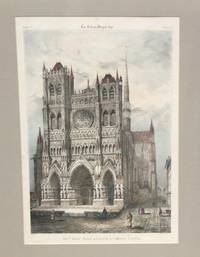
XIII me.Siecle. Portail principal de la Cathedrale d'Amiens.
by Laplante
- Used
- very good
- Condition
- Used - Very Good
- Quantity Available
- 1
- Seller
-
Toronto, Ontario, Canada
- Item Price
-
£306.15£20.41 shipping to USA
Show Details
Description:
Paris: Imp.Lemercier, Benard et, Ce., c.1860. Very Good. Notes: Published in Les Arts au Moyen Age.The Cathedral Basilica of Our Lady of Amiens, or simply Amiens Cathedral, is a Roman Catholic church. The cathedral is the seat of the Bishop of Amiens. , Image Size : 409x284 (mm), 16.10x11.18 (Inches), Platemark Size : , Paper Size : , Coloring: Hand Colored, Medium: Lithograph, Categories: Views Europe France Others; Architectural General; Religious Christianity;
Item Price
£306.15
£20.41
shipping to USA

XV. Qvae Ratio Conditiove Portvvm et Navivm Stationis ad ciuitatem Bantam, insulasque & flumina
by Becker, Matthaus
- Used
- very good
- Condition
- Used - Very Good
- Quantity Available
- 1
- Seller
-
Toronto, Ontario, Canada
- Item Price
-
£306.15£20.41 shipping to USA
Show Details
Description:
Germany, c.1601. Very Good. Notes: Text in Latin. , Size : 134x175 (mm), 5.28x6.89 (Inches), Coloring: Black & White, Category: Maps Asia South East Indonesia & Papua New Guinea;
Item Price
£306.15
£20.41
shipping to USA

XVII Provinciae Belgii sive Germaniae Inferioris....
by Tobias Conrad Lotter
- Used
- Condition
- Used - Very Good; some toning of the paper
- Quantity Available
- 1
- Seller
-
Toronto, Ontario, Canada
- Item Price
-
£714.35£20.41 shipping to USA
Show Details
Description:
Augsburg, 1758. Very Good; some toning of the paper. Size : 500x586 (mm), 19.69x23.07 (Inches), Coloring: Original Hand Coloring, Category: Maps Europe Benelux;
Item Price
£714.35
£20.41
shipping to USA

XXV Universal Descrittione Dell Asia. Asia.
by Porcacchi, Tommaso
- Used
- Condition
- Used - Very Good;
- Quantity Available
- 1
- Seller
-
Toronto, Ontario, Canada
- Item Price
-
£714.35£20.41 shipping to USA
Show Details
Description:
Venice, c.1575. Very Good;. Size : 177x137 (mm), 6.97x5.39 (Inches), Coloring: Hand Colored, Category: Maps Asia Continent;
Item Price
£714.35
£20.41
shipping to USA

XXVIII. Descrittione Del Potentissimo Imperio della Tartariae. Tartaiae Imperium
by Girolamo Porro
- Used
- very good
- Condition
- Used - Very Good
- Quantity Available
- 1
- Seller
-
Toronto, Ontario, Canada
- Item Price
-
£469.43£20.41 shipping to USA
Show Details
Description:
Germany: Battista & Giorgio Galignani Fratelli, c. 1598. Very Good. Notes: An early map of Eastern Asia depicting Japan, China, Russia, Mongolia, and Central Asia. Also shows the North Western parts of North America., Size : 136x178 (mm), 5.35x7.01 (Inches), Coloring: Hand Colored, Category: Maps Asia Continent; Maps Russia;
Item Price
£469.43
£20.41
shipping to USA

XXXVIII. Effigies Sinvs, Sev Angvstiae Nassav, Cvm Adiunctis Caeteris.
by Theodore De Bry
- Used
- very good
- Condition
- Used - Very Good
- Quantity Available
- 1
- Seller
-
Toronto, Ontario, Canada
- Item Price
-
£469.43£20.41 shipping to USA
Show Details
Description:
Germany, c.1601. Very Good. Notes: This map shows representation of the second Dutch expedition to find a Northern route to Asia. The fleet of seven ships is seen entering Waijgats Strait, into the Kara Sea - here called 'Nier Mare'. The southernmost point of Novaya Zemlya is depicted in the top-half of the engraving., Size : 136x176 (mm), 5.35x6.93 (Inches), Coloring: Black & White, Category: Maps Polar Arctic Regions; Maps Russia;
Item Price
£469.43
£20.41
shipping to USA

Xaintonge.
by Joannis Janssonius
- Used
- very good
- Condition
- Used - Very Good
- Quantity Available
- 1
- Seller
-
Toronto, Ontario, Canada
- Item Price
-
£306.15£20.41 shipping to USA
Show Details
Description:
Amsterdam, 1651. Very Good. Size : 150x192 (mm), 5.875x7.5 (Inches), Coloring: Original Outline Coloring, Category: ; Maps Europe France
Item Price
£306.15
£20.41
shipping to USA

Xantung, e Peking Provincie della China divise nelle sue Regioni, e dedicate a Mons.re Rev.mo Severoli, Referendario dell'una e laltra Signatura dal P.M. Coronelli M.C. Cosmografio della Ser.ma Republica di Venetia.
by P.M. Coronelli
- Used
- Condition
- Used - Very Good;
- Quantity Available
- 1
- Seller
-
Toronto, Ontario, Canada
- Item Price
-
£816.40£20.41 shipping to USA
Show Details
Description:
Venice: Domenico Padovani, c. 1695. Very Good;. Size : 449x598 (mm), 17.68x23.54 (Inches), Coloring: Hand Colored, Category: Maps Asia Far East China;
Item Price
£816.40
£20.41
shipping to USA

Didn’t find what you’re looking for?
Try adding this search to your want list. Millions of books are added to our site everyday and when we find one that matches your search, we’ll send you an email. Best of all, it’s free.
Add to Want List

Are you a frequent reader or book collector?
Join the Bibliophile's Club and save 10% on every purchase, every day — up to $20 savings per order!

Social Responsibility
Did you know that since 2004, Biblio has used its profits to build 16 public libraries in rural villages of South America?
