Description:
Chicago: Rand McNally & Co., 1917. Very good lithographic color, folds as issued, with virtually no fold separations. Original paper lettered wraps intact, with rear cover trimmed a bit at outer edge. Inset: General War Map, lower left corner. Very detailed, with coded city/town locations verso for Belgium, Luxemburg and France. The image measures 20.5 x 30.5 inches (52 x 78 cm), with elaborate road and waterway detail. Folds into paper covers measuring 6 x 4 inches. This was one of a series of "Five Great Military Maps of the Western Front in Europe," with this map being no. 2 of the series (list inside front cover). The date is approximate. (No. 2) appears at top of front cover title. Cover also indicates: "Presented in Minute Detail with Cities, Towns and Villages, Forts and Fortified Places, Railroads and Highways, Rivers and Canals, the Forests, and the Physical and Political Features of the Regions" and "Compiled from the Latest Military Maps of the Army Staffs in…
Read More Search Results: Titles starting with W from The Prime Meridian: Antique Maps & Books
You searched for:
- Bookseller inventory: The Prime Meridian: Antique Maps & Books (titles starting with W)
- Bookseller: The Prime Meridian: Antique Maps & Books
Results 1 - 20 of 41

(WW I, Military): Rand McNally War Map of the French Front Northern Section, A Strategic Map of the Battle Ground in France from St. Quentin to St. Mihiel Showing the Farthest Advance of the Germans in 1914...Battle Line 1917
by Rand McNally & Co
- Used
- very good
- Paperback
- Condition
- Used - Very Good
- Binding
- Paperback
- Quantity Available
- 1
- Seller
-
Crozet, Virginia, United States
- Item Price
-
£97.12£6.88 shipping to USA
Show Details
Item Price
£97.12
£6.88
shipping to USA
(WW I, Military): Rand McNally War Map of the French Front Northern Section, A Strategic Map of the Battle Ground in France from St. Mihiel to the Swiss Border Showing the Farthest Advance of the Germans in 1914...Battle Line 1917
by Rand McNally & Co
- Used
- very good
- Paperback
- Condition
- Used - Very Good
- Binding
- Paperback
- Quantity Available
- 1
- Seller
-
Crozet, Virginia, United States
- Item Price
-
£89.02£6.88 shipping to USA
Show Details
Description:
Chicago: Rand McNally & Co., 1917. Very good lithographic color, folds as issued, with virtually no fold separations (vertical cut extending approximately 7 inches lower map, without image loss, repaired verso with archival paper tape). Original paper lettered wraps intact. Inset: General War Map, lower left corner. Very detailed, with coded city/town locations verso for France and a small portion of Germany. The image measures 30.5 x 20.5 inches (78 x 52 cm), with elaborate road and waterway detail. Folds into paper covers measuring 6 x 4 inches. This was one of a series of "Four Great Military Maps of the Western Front in Europe," with this map being no. 3 of the series (list inside front cover). The date is approximate. (No. 3) appears at top of front cover title. Cover also indicates: "Presented in Minute Detail with Cities, Towns and Villages, Forts and Fortified Places, Railroads and Highways, Rivers and Canals, the Forests, and the Physical and Political Features of the…
Read More Item Price
£89.02
£6.88
shipping to USA
(Waterway Profile Chart for Proposed Pacific Railroads): Profile of Routes Proposed for a Pacific Rail Road Compiled to Accompany the Report of the Hon. Jefferson Davis Sec. Of War
by Warren, G.K., Abbot, H.L
- Used
- Condition
- Used
- Quantity Available
- 1
- Seller
-
Crozet, Virginia, United States
- Item Price
-
£242.79£6.88 shipping to USA
Show Details
Description:
1855. VG, with one or two early, small separations at crease junctions. Minimal browning. This was done by Warren and Abbot while Jefferson Davis was Secretary of War. Includes profile sketches of almost all western waterway profiles (Puget Sound, Columbia river, Great Salt Lake, North Fork of Platte River, Gulf of California and others). This was done to accompany Goveurneur Warren's maps. This large b&w image (folds as issued) measures 20x45 inches..
Item Price
£242.79
£6.88
shipping to USA
The Wilderness Campaign May-June 1864 (vol. IV of Papers of the Military Historical Society of Massachusetts)
by The Military Historical Society of Massachusetts
- Used
- Condition
- Used
- Quantity Available
- 1
- Seller
-
Crozet, Virginia, United States
- Item Price
-
£182.09£6.88 shipping to USA
Show Details
Description:
The Military Historical Society of Massachusetts, Boston, 1905. VG, HB, no DJ (as issued), 471pp including index, with 6 b&w folding maps in rear (From the Rapidan to the James, The Wilderness, Spottsylvania Court House, The North Anna, The Totopotomoy, Cold Harbor). All the maps are in excellent conditon (there are a few minor marginal tears, none crossing neatlines of map). This book contains 16 separate essays read before the society between 1887 and 1899. The cover is a bit bumped and rubbed, with minor fraying at ends of spine, but the binding is tigh t..
Item Price
£182.09
£6.88
shipping to USA
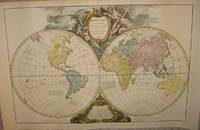
(Word Map): Orbis vetus in utrâque continente juxta mentem Sansonianam distinctus, nec non observationibus astronomicis redactus, accurante
by Robert de Vaugondy, Didier; Robert de Vaugondy, Gilles
- Used
- Condition
- Used
- Quantity Available
- 1
- Seller
-
Crozet, Virginia, United States
- Item Price
-
£1,533.62£6.88 shipping to USA
Show Details
Description:
Paris: apud autorem and Aut. Boudet, 1752. Very good, early hand color, wide margins on laid paper. This is a rather decorative double hemisphere (eastern and western) image.Two watermarks visible verso. Two cartouches upper (title) and lower (notes) central map. The date on the map is 1752, but this is from an "Atlas Universel..." ca. 1757. An image of the map appears in the online David Rumsey Map Collection. Each hemisphere is 35 cm (13.75 inches) in diameter, on a sheet measuring 53 x 83 cm (21 x 32 5 inches), including margins. (Ref: Pedley. Belle et utile, p. 135, no.13.). Map.
Item Price
£1,533.62
£6.88
shipping to USA
World Atlas (Collector's Edition)
by Hammond, Inc
- Used
- Hardcover
- Condition
- Used
- Binding
- Hardcover
- Quantity Available
- 1
- Seller
-
Crozet, Virginia, United States
- Item Price
-
£40.46£6.88 shipping to USA
Show Details
Description:
Hammond Inc., Maplewood (NJ), 1960. HB vg, blue leather, 4vo, 352pp, no DJ. Very nice copy of this well-known atlas..
Item Price
£40.46
£6.88
shipping to USA
(World Map- Mercator Projection): Mappemonde Suivant La Projection Mercator
by Malte-Brun (JJN Huot)
- Used
- Condition
- Used
- Quantity Available
- 1
- Seller
-
Crozet, Virginia, United States
- Item Price
-
£76.88£6.88 shipping to USA
Show Details
Description:
Paris: Garnier Freres, 1880. Very good, hand colored outlines, later Malte-Brun map from "Atlas de Geographie Universelle...". The above date is approximate. The attractive double plate image measures 12x16.5 inches..
Item Price
£76.88
£6.88
shipping to USA
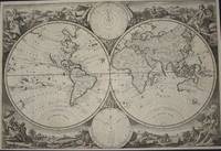
(World Map- Double Hemispheres): Mappe - Monde Par Le S. Robert De Vaugondy...1780
by Robert de Vaugondy
- Used
- Condition
- Used
- Quantity Available
- 1
- Seller
-
Crozet, Virginia, United States
- Item Price
-
£242.79£6.88 shipping to USA
Show Details
Description:
Paris: Chez le Sr. Fortin , 1780. VG+, minimal edge browning and foxing. Nicely hand colored outlines, heavy paper, double hemisphere, peninsular California. This is plate 1 from a 1778 edition (later issue; clearly marked on title page, even though map itself lists 1780 in cartouche) of the family's "Nouvel Atlas Portatif" (see Pedley's "Bel et Utile" re: historical details for this prominent mapmaking family). The image measures 10.5x16.5 inches..
Item Price
£242.79
£6.88
shipping to USA
(World Map): Orbis Terrarum
by Kiepert, Henry
- Used
- Condition
- Used
- Quantity Available
- 1
- Seller
-
Crozet, Virginia, United States
- Item Price
-
£24.28£6.88 shipping to USA
Show Details
Description:
Williams & Norgate, London & Edingurgh, 1891. Fine printed color. Several insets at various times. Color coded w/racial info. All of Africa labelled "Aethiopia". From the 12th edition of "Atlas Antiquus. Twelve Maps of the Ancient World for Schools and Colleges". The German editions were public hed by Dietrich Reimer in Berlin. 32x41.5cm..
Item Price
£24.28
£6.88
shipping to USA
(World Map- from Ortelius): Mappemonde D'Ortelius 1587. Fac-simile Heliographique
by Vivien De Saint-Martin
- Used
- Condition
- Used
- Quantity Available
- 1
- Seller
-
Crozet, Virginia, United States
- Item Price
-
£52.60£6.88 shipping to USA
Show Details
Description:
Paris: Librairie Hachette et Cie, Boulevard Saint-Germain, 1874. VG, b&w heliographic copy of Ortelius' "Typvs Orbis Terrarvm." This is from Vivien's scarce "Atlas Dresse Pour L'Histoire de la Geographie et Decouvertes Geographiques...". A nice, double-folio image measuring 14x18 inches. .
Item Price
£52.60
£6.88
shipping to USA
(World Map-- Twin Hemi; 2 separate sheets): Eastern Hemisphere, Western Hemisphere
by Farwell
- Used
- Condition
- Used
- Quantity Available
- 1
- Seller
-
Crozet, Virginia, United States
- Item Price
-
£40.46£6.88 shipping to USA
Show Details
Description:
Chicago: J. V. Farwell Co., 1891. VG w/some marginal browning. Full printed color. 2 separate sheets, w/population density grid diagrams for Great Britain and Asia (on eastern sheet); Europe/America, USA (western sheet). Each image 30x24cm..
Item Price
£40.46
£6.88
shipping to USA
(World Map- Tidal Chart): Erdkarte Zur Ubersicht Der Isoraachien Oder Dinien Gleicher Fluthzeit
by Von Humboldt, Alexander (engr. by T. Bromme)
- Used
- Condition
- Used
- Quantity Available
- 1
- Seller
-
Crozet, Virginia, United States
- Item Price
-
£97.12£6.88 shipping to USA
Show Details
Description:
Stuttgart: Carl Hoffman, 1864. VG with mild marginal browning. Original printed two-toned coloring with isolinear summaries of tides around the world (after Whewell) This is plate 15 from the 1864 edition of Humboldt's "Atlas zu Alexander von Humboldt's Kosmos...". Johnston's original "Physical Atlas..." was dedicated to von Humboldt. The attractive image measures 8.25x11 inches (21x28cm)..
Item Price
£97.12
£6.88
shipping to USA
(World Map- Just Pre-Columbus): Le Monde Connu En 1491 Avant Le Premier Voyage De Colomb
by Vivien De Saint-Martin
- Used
- Condition
- Used
- Quantity Available
- 1
- Seller
-
Crozet, Virginia, United States
- Item Price
-
£60.70£6.88 shipping to USA
Show Details
Description:
Paris: Librairie Hachette et Cie, Boulevard Saint-Germain, 1874. VG, with two-toned printed color and modest topographic detail. A nice image, with both eastern and western hemispheres, hand colored outlines (partial). There are 3 insets: two of which pertain to views by Martin Behaim in 1492, and a third from Toscanelli in 1474 This is from Vivien's scarce "Atlas Dresse Pour L'Histoire de la Geographie et Decouvertes Geographiques...". A very nice, double-folio image measuring 14x18 inches. .
Item Price
£60.70
£6.88
shipping to USA
(World Map- 4 Plates, 1 Sheet: T-O Map Variations of Pre-Christian World, Eratosthenes, Strabo): Erdansichten Der Alten
by Von Humboldt, Alexander (engr. by T. Bromme)
- Used
- Condition
- Used
- Quantity Available
- 1
- Seller
-
Crozet, Virginia, United States
- Item Price
-
£121.40£6.88 shipping to USA
Show Details
Description:
Stuttgart: Carl Hoffman, 1864. VG with mild marginal browning. Original printed two-toned coloring with 4 plates on a single sheet. Several appear to be variations on the T-O maps, ranging from 900-20 BCE. The dominant plate, attributed to Eratosthenes (but dated well after the Greek astronomer's death) and Strabo (more prominent intellectually with his contemporaries, and temporally closer to the date applicable to the image) is coded into temperature zones. Eratoshtenes used his mathematical background to calculate various details pertaining to geographical distance. ( Both men, including Strabo's criticism of Eratosthenes, are discussed in Thrower's MAPS AND CIVILIZATION). This is a very unusual and interesting set of images. This is plate 38 from the 1864 edition of Humboldt's "Atlas zu Alexander von Humboldt's Kosmos...". Johnston's original "Physical Atlas..." was dedicated to von Humboldt. The attractive image measures 8.25x11 inches (21x28cm)..
Item Price
£121.40
£6.88
shipping to USA
(World Maps of Middle Ages- 2 Map Set): Cartographie Du Moyen-Age
by Vivien De Saint-Martin
- Used
- Condition
- Used
- Quantity Available
- 1
- Seller
-
Crozet, Virginia, United States
- Item Price
-
£141.63£6.88 shipping to USA
Show Details
Description:
Paris: Librairie Hachette et Cie, Boulevard Saint-Germain, 1874. VG, with simple printed two-tone color depicting various famous maps during the middle ages. This is a 2 map set, each double-folio. Copies of map images of Peutinger, Strutt, Sanuto, Ranulphus, Mordtmann, Mauro and others are shown. A very unusual display. This is from Vivien's scarce "Atlas Dresse Pour L'Histoire de la Geographie et Decouvertes Geographiques...". A nice, interesting double-folio pair of images each measuring 14x18 inches. .
Item Price
£141.63
£6.88
shipping to USA
(World Map- Mercator Projection): Mappe Monde Suivant La Projection Des Cartes Reduites Par Le S. Robert De Vaugondy...1778
by Robert de Vaugondy
- Used
- Condition
- Used
- Quantity Available
- 1
- Seller
-
Crozet, Virginia, United States
- Item Price
-
£242.79£6.88 shipping to USA
Show Details
Description:
Paris: Chez le Sr. Fortin , 1778. VG+, minimal edge browning and foxing. Folds as issued. Color coded by religious distribution. Nicely hand colored outlines, heavy paper, double hemisphere, peninsular California. This is plate 2 from a 1778 edition (later issue) of the family's "Nouvel Atlas Portatif" (see Pedley's "Bel et Utile" re: historical details for this prominent mapmaking family). The image measures 9.5x15.5 inches..
Item Price
£242.79
£6.88
shipping to USA
(World Map- Antipodes, Continents): Der Erdkorper in Seiner Gestaltung
by Von Humboldt, Alexander (engr. by T. Bromme)
- Used
- Condition
- Used
- Quantity Available
- 1
- Seller
-
Crozet, Virginia, United States
- Item Price
-
£121.40£6.88 shipping to USA
Show Details
Description:
Stuttgart: Carl Hoffman, 1864. VG with mild marginal browning. Original hand coloring with multiple, striking images of continental interrelationships. This is plate 5 from the 1864 edition of Humboldt's "Atlas zu Alexander von Humboldt's Kosmos...". Johnston's original "Physical Atlas..." was dedicated to von Humboldt. The attractive image measures 8.5x117.5 inches (21.5x30cm)..
Item Price
£121.40
£6.88
shipping to USA
(World Map - 13th Century)): Monde Connu Au XIIIe. Siecle
by Vivien De Saint-Martin
- Used
- Condition
- Used
- Quantity Available
- 1
- Seller
-
Crozet, Virginia, United States
- Item Price
-
£60.70£6.88 shipping to USA
Show Details
Description:
Paris: Librairie Hachette et Cie, Boulevard Saint-Germain, 1874. VG, with tw-toned printed color and a good bit of topographic detail. The Mongol Empire is noted, along with the period routes of Marco Polo and other explorers. South Africa is cut off, as expected for the times. This is from Vivien's scarce "Atlas Dresse Pour L'Histoire de la Geographie et Decouvertes Geographiques...". A very nice, double-folio image measuring 14x18 inches. .
Item Price
£60.70
£6.88
shipping to USA
(World Map from Keur bible): Wereldkaart
by Jagen, Jan Van
- Used
- very good
- Condition
- Used - Very Good
- Quantity Available
- 1
- Seller
-
Crozet, Virginia, United States
- Item Price
-
£2,387.44£6.88 shipping to USA
Show Details
Description:
Dordrecht: Keur, 1748. Very good double hemisphere world map from a Keur bible, b&w as issued. The engraver/designer for this map was J. v. Jagen (sculps. et dir.; engraved on lower central edge of plate just inside neatline). Folds as issued. Two smaller spheres upper (Polus Arcticus) and lower (Polus Antarcticus) center. The majority of place names and verso text are in Dtuch. The decorative allegorical surrounds are quite nice. The map image measures 30 x 45 cm, with the diameter of each hemisphere measuring 22 cm. The Keur family were active bible publishers from the mid 17th to mid 18th centuries. This particular map corresponds to variant K III, entry 137, p. 205 in Poortman and Augusteijn's "Kaarten in Bijbels..." The map date is approximate. There is no recto title banner for this issue.. Very Good. Map.
Item Price
£2,387.44
£6.88
shipping to USA
(World Map- Southern Equatoial View): Mappe Monde Su Le Plan De L'Equateur. Hemisphere Meridional
by Bonne, Rigobert (with Desmarest)
- Used
- Condition
- Used
- Quantity Available
- 1
- Seller
-
Crozet, Virginia, United States
- Item Price
-
£141.63£6.88 shipping to USA
Show Details
Description:
Paris: Hotel De Thou, Rue Des Poitevins, 1787. VG+, b&w as issued, copperplate on heavy paper. A very nice image from "Atlas Encyclopedique...", done by Bonne and Desmarest and published in two volumes in 1787-88. These maps are a bit larger than those from the 1780 Bonne atlas. An attractive southern hemispheric view with Africa, a shell of Australia, and south America and southern Africa (plate 23), measures 9.5x13.5 (24x34cm)..
Item Price
£141.63
£6.88
shipping to USA

Didn’t find what you’re looking for?
Try adding this search to your want list. Millions of books are added to our site everyday and when we find one that matches your search, we’ll send you an email. Best of all, it’s free.
Add to Want List

Are you a frequent reader or book collector?
Join the Bibliophile's Club and save 10% on every purchase, every day — up to $20 savings per order!

Social Responsibility
Did you know that since 2004, Biblio has used its profits to build 16 public libraries in rural villages of South America?
