Description:
New York: M. & B. Brown Printing and Binding Co., 1916. This was produced for the company's annual report, and is very detailed, in very good condition, with virtually every whistlestop, extending through Kansas, Missouri, Texas, New Mexico, Arizona, California and Colorado, with the eastward connection to Chicago. .The printed color image, on thin paper, measures 16x25 inches..
Search Results: Titles starting with R from The Prime Meridian: Antique Maps & Books
You searched for:
- Bookseller inventory: The Prime Meridian: Antique Maps & Books (titles starting with R)
- Bookseller: The Prime Meridian: Antique Maps & Books
Results 1 - 20 of 22

(Railroad Map): The Atchison, Topeka and Santa Fe Railway System
by M. & B. Brown Printing and Binding Company
- Used
- Condition
- Used
- Quantity Available
- 1
- Seller
-
Crozet, Virginia, United States
- Item Price
-
£89.02£6.88 shipping to USA
Show Details
Item Price
£89.02
£6.88
shipping to USA
(Railroad Map): The Atchison, Topeka and Santa Fe Railway System
by American Bank Note Company
- Used
- Condition
- Used
- Quantity Available
- 1
- Seller
-
Crozet, Virginia, United States
- Item Price
-
£101.16£6.88 shipping to USA
Show Details
Description:
American Bank Note Company (for the Atchison, Topeka & Santa Fe Railroad), 1910. This was produced for the company's annual report, and is very detailed, in very good condition, with virtually every whistlestop, extending through Kansas, Missouri, Texas, New Mexico, Arizona, California and Colorado, with the eastward connection to Chicago. The American Bank Note Company produced a number of maps for major railroad companies of the late 19th and early 20th century (see Modelski's "Railroad Maps of North America"). This particular map is a later variant of item #325 in Modelski's "Railroad Maps of the United States".The printed color image, on thin paper, measures 16x25 inches..
Item Price
£101.16
£6.88
shipping to USA
(Railroad Map): London and Birmingham Railway
by Stephenson, Robert (engineer)
- Used
- very good
- Hardcover
- first
- Condition
- Used - Very Good
- Edition
- First Edition Thus
- Binding
- Hardcover
- Quantity Available
- 1
- Seller
-
Crozet, Virginia, United States
- Item Price
-
£465.35£6.88 shipping to USA
Show Details
Description:
London: C. F. Cheffins, 9 Southampton Buildings, 1838. Map with folds as issued, overall very good condition with original hand color, a few fold separations (no image loss) with a couple of partial repairs verso (clear, archival paper tape, so verso text completely legible). Two sheets folded into the stiff, green paper boards (title on boards "Map of the London & Birmingham Railway, and the Adjacent Country 1837). Although the boards tate 1837, the map itself clearly stipulates a publication date of Jan. 1, 1838, and is stated to be "The Company's Official Map..." The boards measure 6 x 3.75 inches, and are a bit scuffed and wrinkled, with the pasted label missing a piece from the right lower corner, but with the printing generally intact. The map is in two sheets, on stiff paper, with the title sheet runs from London westward to "Pt. of Oxon," and the second sheet runs from Towcester west past Birmingham. The image on both sheets measures approximately 11 x 27…
Read More Item Price
£465.35
£6.88
shipping to USA
(Railroad Map- Kansas): Map Showing the Atchison, Topeka and Santa Fe Railroad and It's Auxilliary Roads in the State of Kansas. June 30th 1890
by Colton, GW & CB
- Used
- Condition
- Used
- Quantity Available
- 1
- Seller
-
Crozet, Virginia, United States
- Item Price
-
£222.56£6.88 shipping to USA
Show Details
Description:
New York: GW & CB Colton & Co., 312 Broadway , 1890. Fine condition, color coded for railroad routes. Left upper margin close as bound into report ("Eighteenth Annual Report...Atchison, Topeka & Santa Fe Railroad Company...Fiscal Year ended June 30, 1890.") A later edition of map (just prior to a major corporate reorganization) 324 in Modelski's "railroad Maps of the United States". Folds as issued. Very detailed with all connecting lines of the railroad in the state of Kansas. The strong image measures 15.75x23 inches (40x58.5cm). The rear board of the report is separated, but present, and the covers are a bit chipped at the edges, most noticeable on the spine. The report itself is complete..
Item Price
£222.56
£6.88
shipping to USA
(Railroad Map- Illinois, Chicago, Great Lakes): Map of the Lake Shore and Michigan Southern R'Y (Railway)
by Poole Bros. (compiled and Edited By W.F. Allen)
- Used
- Condition
- Used
- Quantity Available
- 1
- Seller
-
Crozet, Virginia, United States
- Item Price
-
£72.84£6.88 shipping to USA
Show Details
Description:
New York: National Railway Publication Company, 1882. Scarce, B&W as issued, small map of the Michigan & SOuthern, which skirted the southern edges of Lakes Michigan and Erie, from Chicago to Buffalo. Shows every whistlestoop, near the peak of the railroad expansions, and was published as part of the "Travelers' Official Railway Guide...". The map image measures 6.25x9 inches..
Item Price
£72.84
£6.88
shipping to USA
(Railroad Map): The Atchison, Topeka and Santa Fe Railway System
by American Bank Note Company
- Used
- Condition
- Used
- Quantity Available
- 1
- Seller
-
Crozet, Virginia, United States
- Item Price
-
£101.16£6.88 shipping to USA
Show Details
Description:
American Bank Note Company (for the Atchison, Topeka & Santa Fe Railroad), 1912. This was produced for the company's annual report, and is very detailed, in very good condition, with virtually every whistlestop, extending through Kansas, Missouri, Texas, New Mexico, Arizona, California and Colorado, with the eastward connection to Chicago. The American Bank Note Company produced a number of maps for major railroad companies of the late 19th and early 20th century (see Modelski's "Railroad Maps of North America"). This particular map is a later variant of item #325 in Modelski's "Railroad Maps of the United States".The printed color image, on thin paper, measures 16x25 inches..
Item Price
£101.16
£6.88
shipping to USA
(Railroad Map): The Atchison, Topeka and Santa Fe Railway System
by M. & B. Brown Printing and Binding Company
- Used
- Condition
- Used
- Quantity Available
- 1
- Seller
-
Crozet, Virginia, United States
- Item Price
-
£89.02£6.88 shipping to USA
Show Details
Description:
M. & B. Brown Printing and Binding Co., 1915. This was produced for the company's annual report, and is very detailed, in very good condition, with virtually every whistlestop, extending through Kansas, Missouri, Texas, New Mexico, Arizona, California and Colorado, with the eastward connection to Chicago. The printed color image, on thin paper, measures 16x25 inches..
Item Price
£89.02
£6.88
shipping to USA
(Railroad Map): The Atchison, Topeka and Santa Fe Railway System
by American Bank Note Company
- Used
- Condition
- Used
- Quantity Available
- 1
- Seller
-
Crozet, Virginia, United States
- Item Price
-
£101.16£6.88 shipping to USA
Show Details
Description:
American Bank Note Company (for the Atchison, Topeka & Santa Fe Railroad), 1914. This was produced for the company's annual report, and is very detailed, in very good condition, with virtually every whistlestop, extending through Kansas, Missouri, Texas, New Mexico, Arizona, California and Colorado, with the eastward connection to Chicago. The American Bank Note Company produced a number of maps for major railroad companies of the late 19th and early 20th century (see Modelski's "Railroad Maps of North America"). This particular map is a later variant of item #325 in Modelski's "Railroad Maps of the United States".The printed color image, on thin paper, measures 16x25 inches..
Item Price
£101.16
£6.88
shipping to USA
(Railroad History): Map of the Pennsylvania Rail Road, from Harrisburg to Pittsburg; and of the Columbia & Lancaster & Harrisburg R.R.s from Philadelphia to Harrisburg
by Haupt, H. (Herman)
- Used
- very good
- Paperback
- first
- Condition
- Used - Very Good
- Edition
- First Edition Thus
- Binding
- Paperback
- Quantity Available
- 1
- Seller
-
Crozet, Virginia, United States
- Item Price
-
£805.25£6.88 shipping to USA
Show Details
Description:
Philadelphia: T.K. and P.G. Collins, Printers, 1855. Map with folds as issued, original hand coloring, with a couple of chips at edges but overall in very good condition and image clear. The long, folding image measures roughly 20 x 178 cm. (8 x 70 inches). This is in the original stiff paper covers (9 x 6 inches), titled "Guide for the Pennsylvania Railroad with an Extensive Map; including the Entire Route, with all its Windings, Objects of Interest, and Information Useful to the Traveller." Although the cover is taped (coming loose) at the spine, it is present with a clearly legible title, and all 40 pp. of the textual guide are present and in very good condition. There is a pencilled textual annotation at the top of the title page. This is one of the earliest regional railroad brochures of the region. Reference: LC, "Railroad Maps of the United States," entry 517, p. 87. The map shows county boundaries, cities, towns, boundaries, drainage, and the names of individual lines with…
Read More Item Price
£805.25
£6.88
shipping to USA
(Railroad Map): The Atchison, Topeka and Santa Fe Railway System
by M. & B. Brown Printing and Binding Company
- Used
- Condition
- Used
- Quantity Available
- 1
- Seller
-
Crozet, Virginia, United States
- Item Price
-
£89.02£6.88 shipping to USA
Show Details
Description:
New York: M. & B. Brown Printing and Binding Co., 1917. This was produced for the company's annual report, and is very detailed, in very good condition, with virtually every whistlestop, extending through Kansas, Missouri, Texas, New Mexico, Arizona, California and Colorado, with the eastward connection to Chicago. The printed color image, on thin paper, measures 16x25 inches..
Item Price
£89.02
£6.88
shipping to USA

(Railroad Map): The Atchison, Topeka and Santa Fe Railway System
by American Bank Note Company
- Used
- Condition
- Used
- Quantity Available
- 1
- Seller
-
Crozet, Virginia, United States
- Item Price
-
£101.16£6.88 shipping to USA
Show Details
Description:
American Bank Note Company (for the Atchison, Topeka & Santa Fe Railroad), 1911. This was produced for the company's annual report, and is very detailed, in very good condition, with virtually every whistlestop, extending through Kansas, Missouri, Texas, New Mexico, Arizona, California and Colorado, with the eastward connection to Chicago. The American Bank Note Company produced a number of maps for major railroad companies of the late 19th and early 20th century (see Modelski's "Railroad Maps of North America"). This particular map is a later variant of item #325 in Modelski's "Railroad Maps of the United States".The printed color image, on thin paper, measures 16x25 inches..
Item Price
£101.16
£6.88
shipping to USA
(Railroad Map): The Atchison, Topeka and Santa Fe Railway System
by M. & B. Brown Printing and Binding Company
- Used
- Condition
- Used
- Quantity Available
- 1
- Seller
-
Crozet, Virginia, United States
- Item Price
-
£89.02£6.88 shipping to USA
Show Details
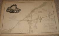
Description:
New York: M. & B. Brown Printing and Binding Co., 1916. This was produced for the company's annual report, and is very detailed, in very good condition, with virtually every whistlestop, extending through Kansas, Missouri, Texas, New Mexico, Arizona, California and Colorado, with the eastward connection to Chicago. .The printed color image, on thin paper, measures 16x25 inches..
Item Price
£89.02
£6.88
shipping to USA
(Rain Map of Europe): Hyetographic or Rain Map of Europe with an Enlarged Rain Map of the British Isles
by Johnston, A. Keith
- Used
- Condition
- Used
- Edition
- 2nd (Revised and Enlarged)
- Quantity Available
- 1
- Seller
-
Crozet, Virginia, United States
- Item Price
-
£76.88£6.88 shipping to USA
Show Details
Description:
Edinburgh: William Blackwood & Sons, 1856. Fine condition, double folio, gilt-edged on heavy paper from the enlarged edition of this important atlas (THE PHYSICAL ATLAS OF NATURAL PHENOMENA). This is an attractive image, with original color, detailing European, with a British Isles inset. The map measures 20x24 inches.. 2nd (Revised and Enlarged).
Item Price
£76.88
£6.88
shipping to USA
(Reference Book- British Cartography): The Printed Maps in the Atlases of Great Britain and Ireland, A Bibliography, 1579-1870....Introduction By F.P. Sprent
by Chubb, Thomas
- Used
- Hardcover
- first
- Condition
- Used
- Edition
- First Edition
- Binding
- Hardcover
- Quantity Available
- 1
- Seller
-
Crozet, Virginia, United States
- Item Price
-
£218.51£6.88 shipping to USA
Show Details
Description:
London: The Homeland Association, Ltd. , 1927. Very good copy, minimal soiling edges (most noticable top fore-edge), few scrapes on spine edges, some cuffing of original boards.. Decorative frontispiece (title page of Saxton's atlas). Interior very good; binding tight, mildly shaken. This is a large (479 pp) basic reference work on this subject. It is increasingly difficult to find.. First Edition. Cloth. 4to - over 9¾" - 12" tall.
Item Price
£218.51
£6.88
shipping to USA
(Reference, City Planning, History): Envisioning the City. Six Studies in Urban Cartography
by Buisseret, David (editor)
- Used
- as new
- Hardcover
- Condition
- As New
- Binding
- Hardcover
- Quantity Available
- 1
- Seller
-
Crozet, Virginia, United States
- Item Price
-
£30.75£6.88 shipping to USA
Show Details
Description:
Chicago: Univ. of Chicago Press, 1998. Small 4to, new, with like DJ. xiii, 181 pp (including index; each chapter has its own independent notes). These essays are "revised versions of the lectures delivered in the tenth series of Kenneth Nebenzahl, Jr., Lectures in the History of Cartography, held at the Newberry Library, Chicago, in November 1991." Subjects cover pertain to city maps of China, the Renaissance, 16th-17th century Spain, military architecture and the early modern city, early modern Europe, Plan of Chicago (Burnham and Bennett). As would be expected, this is a lucid, scholarly and well-written volume.. Cloth. As New/As New. 4to - over 9¾" - 12" tall.
Item Price
£30.75
£6.88
shipping to USA
(Reference; France): Geography Unbound. French Geographic Science from Cassini to Humboldt
by Godlewska, Anne Marie Claire
- Used
- as new
- Hardcover
- first
- Condition
- As New
- Edition
- First Edition
- Binding
- Hardcover
- Quantity Available
- 1
- Seller
-
Crozet, Virginia, United States
- Item Price
-
£263.02£6.88 shipping to USA
Show Details
Description:
Chicago: Univ. of Chicago Press, 1999. Large 8vo., new, xii, 444 pages (including references and index). An impressive academic study by a faculty member a Queens Univ. in Canada. This discusses a long period of intellectual dormancy, if not outright decline, in the study of geography in France from the late 18th until the late 19th century. Whether one agrees or not with her analysis, this is a carefully disclosed and argued presenatation, clearly written and very well referenced. She discusses elements pertaining to physical, human and historical geography.. First Edition. Cloth. As New. 8vo - over 7¾" - 9¾" tall.
Item Price
£263.02
£6.88
shipping to USA
(Reproduction Edition- Maps, Holy Land): Pisgah Sight of Palestine and the Confines Thereof; with the History of the Old and New Testament Acted Thereon
by Fuller, Thomas
- Used
- very good
- Hardcover
- Condition
- Used - Very Good
- Binding
- Hardcover
- Quantity Available
- 1
- Seller
-
Crozet, Virginia, United States
- Item Price
-
£263.02£6.88 shipping to USA
Show Details
Description:
London: William Tegg, 1869. A smaller reproduction edition (642pp plus index) with copies (smaller format than original) of all the maps / plates, double frontispieces of the 1650 edition from St. Paul's Churchyard. This would make a very useful reference source. Contemporary covers rubbed/scuffed, but all text and 28 plate reproductions quite clean. Binding tight, front inner hinge starting. Nebenzahl, in his "Maps of the Holy Land" refers to Fuller's work as one of landmark significance in the mapping of the region.. Cloth. Very Good. 8vo - over 7¾" - 9¾" tall.
Item Price
£263.02
£6.88
shipping to USA
[Revised Facsimile, Washington, DC]: Plan of the City Intended for the Permanent Seat of the Government of the United States
by L'Enfant, Pierre Charles
- Used
- very good
- Condition
- Used - Very Good
- Quantity Available
- 1
- Seller
-
Crozet, Virginia, United States
- Item Price
-
£311.58£6.88 shipping to USA
Show Details
Description:
Washington (DC): U.S. Coast and Geodetic Survey, 1976. L'Enfant's original landmark plan of August 1791 was copied and reproduced in 1887 by the U.S. Coast & Geodetic Survey. According to F.M. Thorn's (Superintendent) note on the map, this reproduction "...is as nearly complete and exact as trained skill, care, and the use of the best appliances can make it; that it contains no lines, letters, or figures which are not legibly indicated on the original; and that nothing has been inserted or supplied from inference." Copies of the plan were made between 1893 and 1991, and color was added in 1958. (The original plan was transferred to the Library of Congress in 1918). This particular copy was issued in 1976, for the US bicentennial celebrations. The image measures 30 x 46.5 inches (76 x 118 cm) and has been stored rolled, in very good (or better) condition. The map also displays a report of B.A. Colonna, Assistant, US Coast and Geodetic Survey, in charge of the office and topography. (Reference: Scott…
Read More Item Price
£311.58
£6.88
shipping to USA
(Revolutionary War Era): A map of the inhabited part of Canada from the French surveys; wiith the frontiers of New York and New England from the large surveys
by Sauthier, Claude Joseph
- Used
- very good
- first
- Condition
- Used - Very Good
- Edition
- First Edition Thus
- Quantity Available
- 1
- Seller
-
Crozet, Virginia, United States
- Item Price
-
£3,075.34£6.88 shipping to USA
Show Details
Description:
London: Wm. Faden, 1777. Very good, minimal wash color as issued, with remarks indicating the survey order of Genr. Pownall. This uncommon map relates to the invasion of Canada. A few small archival taped repairs in margin verso. Heavy paper, very ittle browning This is the later state (2nd), with the dedication to Major General John Burgoyne, and the table of the "Winter Quarters of the Kings Army in Canada..." Below the cartouche: London, Published as the Act directs, Feby. 25. 1777 by Wm. Faden, Corner of St. Martin's Lane, Charing Cross. Ref: McCorckle, New England in Early Printed Maps, entry 777.19; Nebenzahl, entry 43. Folds as issued. Image measures 57 x 85 cm (22.5 x 33. 5 inches).. First Edition Thus. Very Good. Map.
Item Price
£3,075.34
£6.88
shipping to USA
(River Survey, US Coast Survey): Ohio River Between Mound City and Cairo
by Bache, A. D
- Used
- very good
- Condition
- Used - Very Good
- Quantity Available
- 1
- Seller
-
Crozet, Virginia, United States
- Item Price
-
£68.79£6.88 shipping to USA
Show Details
Description:
Washington (DC): US Coast Survey, 1866. Near fine but for small extra crease right upper corner due to being folded in book. B&W, with folds as issued, on thin paper. This chart shows the mouth of the Ohio River where it joins the Mississippi, at the border region of Illinois and Kentucky. Small plans of Mound City and Cairo are present, with a few major buildings (hospital, Naval depot, foundry) shown in the former. Branches of the Illinois Central Railroad are shown in both cities. This was "surveyed by the party of F.H. Gerdes...under orders of Rear Admiral D.D. Porter...Mississippi Squadron." The date on the chart is 1864, but it was included in the 1866 report of the superintendent of the Coast Survey, Alexander Dallas Bache, who was the great grandson of Benjamin Franklin. There are fairly detailed depth soundings of the Ohio River from this area. The number 31 is printed on the chart verso. The image measures 37 x 54 cm.. Very Good. Map.
Item Price
£68.79
£6.88
shipping to USA

Didn’t find what you’re looking for?
Try adding this search to your want list. Millions of books are added to our site everyday and when we find one that matches your search, we’ll send you an email. Best of all, it’s free.
Add to Want List

Are you a frequent reader or book collector?
Join the Bibliophile's Club and save 10% on every purchase, every day — up to $20 savings per order!

Social Responsibility
Did you know that since 2004, Biblio has used its profits to build 16 public libraries in rural villages of South America?
