Description:
New York,: Ziff-Davis for PC World,, 1995.. 622 by 952mm. (24.5 by 37.5 inches).. Colour printed folding map, printed on both sides. As the legend says: "There are tons of freebies sitting on the Web, FTP, and Gopher sites all over the world. The major categories you'll find here are Applications & Utilities, Internet Software, Resources, and Entertainment & Games. Everybody wants to try out our new software, so that predominates. But don't overlook the Net's many and varied resources, they offer some surprising advantages. Naturally, once you've finished with all the useful stuff you'll want something entertaining. All work and no play, after all
" Signed by the artist, lower left, this early map of the internet is clearly inspired by the form famously pioneered by Harry Beck, for his map of the London Underground, in 1933. This "hub-and-spoke" method of data visualization, untangles the maze that is the world wide web, into four separate threads: 'Applications and Utilities', 'Internet…
Read More Search Results: Titles starting with P from Daniel Crouch Rare Books Ltd
You searched for:
- Bookseller inventory: Daniel Crouch Rare Books Ltd (titles starting with P)
- Bookseller: Daniel Crouch Rare Books Ltd
Results 1 - 20 of 107

More Photos
PC Computing: Road Map to the Best Free Stuff on the Internet.: Once you've finished with all the useful stuff you'll want something entertaining"
by RANDALL, Neil; and Timothy Edward DOWNS
- Used
- Signed
- Condition
- Used
- Quantity Available
- 1
- Seller
-
London, United Kingdom
- Item Price
-
£2,300.00£15.00 shipping to USA
Show Details
Item Price
£2,300.00
£15.00
shipping to USA

More Photos
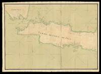
PLAN OF THE TIUTUHO BAY according to measurements of The Hydrographical Expedition of the East Ocean, year 1908.: Plan of the Tiutuho Bay
by Anonymous
- Used
- Condition
- Used
- Quantity Available
- 1
- Seller
-
London, United Kingdom
- Item Price
-
£300.00£15.00 shipping to USA
Show Details
Description:
Unknown,, 1908.. 490 by 540mm. (19.25 by 21.25 inches).. Lithograph chart, pasted to the verso of a British Admiralty chart of Delaware, two manuscript pencil lines and three markings in pink ink. A chart focusing on the Tiutuho Bay, now the area known by its Russian name of Bukhta Rudnaya, which played a key role in the Russo-Japanese War of 1904 to 1905. The early twentieth century saw the Russian powers seeking to expand their power over the Pacific Ocean, making their eastern ports and harbours especially important for maritime trade and naval defences. Tiutuho Bay lies to the north of Russia's most important Pacific seaport of Vladivostok, and much of the war unfurled in the surrounding waters until the conflict was concluded with the Treaty of Portsmouth. In the following years a number of hydrographical expeditions were led by Russian oceanographers across the Northern Hemisphere, and the use of Russian fathoms here suggest that this chart was also conducted by such an expedition. However,…
Read More Item Price
£300.00
£15.00
shipping to USA
![[Pair of maps of India] North India [and] South India.](https://d3525k1ryd2155.cloudfront.net/h/216/910/1162910216.0.m.jpg)
More Photos
[Pair of maps of India] North India [and] South India.: A pair of large London Missionary Society Maps of India
by BACON, G[eorge] W[ashington]
- Used
- Hardcover
- Condition
- Used
- Binding
- Hardcover
- Quantity Available
- 1
- Seller
-
London, United Kingdom
- Item Price
-
£2,200.00£15.00 shipping to USA
Show Details
Description:
London,: G.W. Bacon & Co., 127 The Strand,, [c1900].. (north India) 1110 by 1500mm. (43.75 by 59 inches); (south India) . Pair of lithograph maps on linen, each map on two sheets joined. Rare pair of large wall maps depicting North and South India, Tibet, and Sri Lanka. All major cities are marked together the London Missionary Society's (L.M.S.) stations. Topographical features include rivers, and mountains. The text to the foot of each map implies the main role of these maps was to provide a survey of the L.M.S. stations in India. The cloth cloth loops at the top of each map, show that they were intended to be hung on a wall, of most probably a classroom or an office of the L.M.S. George Washington Bacon (1830-1922) was an American publisher working in Britain. His first business failed and he declared bankruptcy in 1867, but reopened on the Strand in 1870 and built his house into one of the most successful in London. In 1893 it was doing well enough to acquire the stock of James Wyld. He retired…
Read More Item Price
£2,200.00
£15.00
shipping to USA
![[Pair of nine-inch table globes].](https://d3525k1ryd2155.cloudfront.net/h/015/922/1163922015.0.m.1.jpg)
More Photos
[Pair of nine-inch table globes].: Amongst the rarest to survive"
by BLAEU, Willem Janszoon
- Used
- Condition
- Used
- Quantity Available
- 1
- Seller
-
London, United Kingdom
- Item Price
-
£315,000.00£15.00 shipping to USA
Show Details
Description:
Amsterdam,, 1602 [but c1621].. Diameter: 230mm (9 inches).. Terrestrial and celestial globes, each with 12 hand-coloured engraved gores heightened in gold, with two polar calottes, over a papier mâché and plaster sphere, rotating on brass pinions within a brass meridian ring with graduated scale, and a graduated brass altitude quadrant, set into a seventeenth century Dutch wooden base with an engraved horizon ring, adumbrating scales, calendar, almanacs etc. With usual defects: paper equinoctial tables present gaps that are filled and restored, small splits along the gores, several partially deleted entries, small scattered spots but in general in good condition for such an early globe pair, modern hour circles and pointers. Biography Willem Janszoon Blaeu (1571-1638) started "one of the most successful publishing houses of the seventeenth century" (Dekker). Originally trained in astronomy, he quickly became a leading maker of maps, atlases and instruments. At the time the Low Countries hosted the…
Read More Item Price
£315,000.00
£15.00
shipping to USA

Palestinae sive Terre Sancte descriptio... MDLVII.: Franciscus's map of the Holy Land
by FRANCISCUS DELLA GATTA, Johannes
- Used
- Condition
- Used
- Quantity Available
- 1
- Seller
-
London, United Kingdom
- Item Price
-
£12,000.00£15.00 shipping to USA
Show Details
Description:
Rome,, 1557.. 385 by 540mm. (15.25 by 21.25 inches).. Broadsheet engraved map tipped-in to album sheet. Fine example of this extremely rare map of the Holy Land. Franciscus's map of the Holy Land is a remarkable combination of bird's eye view and map. "The shore line runs from Biblus as far as the Nile Delta. The Kishon River is shown connecting the Lake of Tiberias with the Mediterranean Sea. The Wandering of the Jews from Egypt as far as the Jordan River are depicted in military columns. Many biblical cities are shown on the map. Jerusalem is depicted as an impressive city" (Laor). To the upper left is a key to biblical place names, contained within an elaborate cartouche of cupids and tritons. The map is based upon Wolfgang Wissenberg's larger map of the Holy Land published 1537, and dedicated to Archbishop Thomas Cranmer. The map was printed upon eight sheets and measured 105 by 74 cm. Unfortunately, Wissenberg's map is known in only one example, housed in the Bibliotheque Nationale de Paris.…
Read More Item Price
£12,000.00
£15.00
shipping to USA
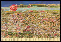
Palo Alto.: Welcome to Palo Alto
by [Anonymous]
- Used
- Condition
- Used
- Quantity Available
- 1
- Seller
-
London, United Kingdom
- Item Price
-
£1,550.00£15.00 shipping to USA
Show Details
Description:
[San Francisco],: City Designs Firm CA,, [c1990s.]. 540 by 770mm. (21.25 by 30.25 inches).. Chromolithograph plan. This map depicts an aerial view of Palo Alto with bold graphics and decorative detail. The view highlights the city with stylised depictions of local businesses, landmarks, and streets. Throughout the map there are small caricature depictions of figures and accompanying slogans, as well as business logos and advertisements. The bottom of the map includes a key of the local businesses with addresses and phone numbers. Part of the Stanford University campus is shown in the lower left hand corner of the map. City Design, a professional graphic art company, was active in the 1980s and 1990s providing maps of various cities and areas across California with its characteristically playful designs. The firm also produced jigsaw puzzles of its maps which it advertised as 'a visual time capsule.' The same firm created another version of the Palo Alto map in 1989. We have been unable to trace…
Read More Item Price
£1,550.00
£15.00
shipping to USA
![[Panorama de Londres vu de la Nacelle d'un Ballon].](https://d3525k1ryd2155.cloudfront.net/h/762/909/1162909762.0.m.0.jpg)
[Panorama de Londres vu de la Nacelle d'un Ballon].: A colour version of Havell's Aeronautical View
by [after HAVELL Jnr., Robert]
- Used
- Condition
- Used
- Quantity Available
- 1
- Seller
-
London, United Kingdom
- Item Price
-
£3,000.00£15.00 shipping to USA
Show Details
Description:
Paris,: Le Roi, Place de Louvre No. 8,, [c.1840].. Image: 270 by 996mm (10.75 by 39.25 inches).. Engraved print with fine contemporary colour, trimmed within platemark, with black wash borders. A close copy of Havell's 'Aeronautical View...' and a trimmed, coloured, example of its French copy.
Item Price
£3,000.00
£15.00
shipping to USA

Panorama de Londres vu de la Nacelle d'un Ballon: A French version of Havell's Aeronautical View
by [after HAVELL Jnr., Robert]
- Used
- Condition
- Used
- Quantity Available
- 1
- Seller
-
London, United Kingdom
- Item Price
-
£3,500.00£15.00 shipping to USA
Show Details
Description:
Paris,: Le Roi, Place de Louvre No. 8,, [c.1840].. Image: 255 by 990mm (10 by 39 inches). Sheet: 315 by 1040mm (12.5 by 41 inches).. Engraving with aquatint. References in French, without key numbers, in lower margin. A close copy of Havell's 'Aeronautical View...'. Rare. We have only been able to trace four other examples of this print; item 25, a coloured example in a private collection, and the institutional examples held by the Guildhall Library and Westminster Art Collection.
Item Price
£3,500.00
£15.00
shipping to USA
![[Panorama of Leiden] Lugdunum Batavorum Hollandia Celeberrimum et Academia Florentissma.](https://d3525k1ryd2155.cloudfront.net/h/287/910/1162910287.0.m.jpg)
More Photos
[Panorama of Leiden] Lugdunum Batavorum Hollandia Celeberrimum et Academia Florentissma.: Seventheenth century Leiden
by RIVET, Claude
- Used
- Signed
- Condition
- Used
- Quantity Available
- 1
- Seller
-
London, United Kingdom
- Item Price
-
£20,000.00£15.00 shipping to USA
Show Details
Description:
Amsterdam,: Johannes Blaeu & Claes Jansz.,, [1650].. 585 by 2120mm (23 by 83.5 inches).. Large engraved panorama on 4 numbered sheets joined, contemporary full wash colour woodcut title in six sections pasted above, three panels of descriptive letterpress text composed of 6 half-sheets, in 18 numbered columns pasted outside the lower border, loss of printed area at right, some minor loss skilfully repaired in facsimile. An important panorama of Leiden from the drawing by Claude Rivet executed in 1640, and originally published by the engraver Jacob Savery. This second state was published by Claes Jansz. Visscher, who signed the dedication and text, and Johannes Blaeu, whose imprint can be found below the dedication.
Item Price
£20,000.00
£15.00
shipping to USA

Panorama de la Habana,: 'Key to the New World and Rampart of the West Indies' (Spanish Royal Decree) Vista tomada desde Regla
by WILLMANN, Eduoard
- Used
- Condition
- Used
- Quantity Available
- 1
- Seller
-
London, United Kingdom
- Item Price
-
£8,000.00£15.00 shipping to USA
Show Details
Description:
Havana,: Rosendo Fernandez & Co,, [1950].. 590 by 1175mm. (23.25 by 46.25 inches).. Engraved view This sweeping panorama of mid-nineteenth century Havana, Cuba, taken from a hill above the town, shows the harbor in the middle distance with the entrance to the right, and was first published in Paris, in about 1855. San Cristóbal de la Habana was founded in 1515 by the Spanish conquistador Diego Velázquez de Cuéllar, possibly near the present town of Batabanó on the south coast of the island. Since the climate was poor, the region was swampy, and the mosquitoes voracious, the site was abandoned in favour of Havana's present location on the north coast of Cuba in 1519. This natural deepwater harbour soon made Havana the most important port in the Caribbean. A Spanish royal decree of 1634 recognized its importance, calling it the 'Llave del Nuevo Mundo y Antemural de las Indias Occidentale', a phrase immortalised on the city's coat of arms. During the seventeenth century, eastbound fleets of…
Read More Item Price
£8,000.00
£15.00
shipping to USA

A Panoramic View of London.: Bank's view of London
by BANKS, J[ohn]. H[enry], by and after
- Used
- Condition
- Used
- Quantity Available
- 1
- Seller
-
London, United Kingdom
- Item Price
-
£1,600.00£15.00 shipping to USA
Show Details
Description:
London,: Entered at Stationer's Hall & Published as the Act Directs by Edward Wallis, No.42, Skinner St, Snow Hill,, [c.1845].. Image: 398 by 995mm (15.75 by 39.25 inches). Sheet: 490 by 1060mm (19.25 by 41.75 inches).. Copper engraving with aquatint with contemporary hand-colour. The third state of the print, with title changed to: 'A Panoramic View of London', here uncoloured. BL Maps 162.n.2.
Item Price
£1,600.00
£15.00
shipping to USA

Par M. Bonne, Ingenieur Hydrographe de la Marine.
by BONNE, Rigobert
- Used
- Condition
- Used
- Quantity Available
- 1
- Seller
-
London, United Kingdom
- Item Price
-
£75.00£15.00 shipping to USA
Show Details
Description:
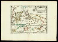
[Geneva,: Jean-Leonard Pellet, , 1780].. 250 by 390mm. (9.75 by 15.25 inches).. Maps,""Carte des Isles de la Sonde, et des Isles Moluques. To accompany Raynal's inflammatory 'Histoire...' Engraved map. Detailed map of Southeast Asia extending to include: the Malay Peninsula showing the island of """"Sin Capora""""; Mindanao in the Philippines; Sumatra and Java; the islands between Borneo and New Guinea; and the northern coastline of Australia. With an inset of the Moluccas lower left. The all-important wind directions, that establish the best navigational routes, are shown. From the atlas volume to accompany the final edition of Guillaume Thomas Francois, l'Abbe Raynal's 'Histoire philosophique et politique des établissemens et du commerce des Européens dans les deux Indes'. The map was subsequently reprinted, omitting Bonne's and the engraver, Andre's, names. Raynal's text for his 'Histoire philophique
', adopted a """"deistical and libertarian attitude associated with Montesquieu and Voltaire,…
Read More Item Price
£75.00
£15.00
shipping to USA
Par le S.r Sanson dAbbeville, Geog.e du Roy Avec privilege pour 20 ans. 1652.
by SANSON, Nicolas
- Used
- Condition
- Used
- Quantity Available
- 1
- Seller
-
London, United Kingdom
- Item Price
-
£300.00£15.00 shipping to USA
Show Details
Description:
[Paris,: chez l'autheur,, 1652].. 265 by 370mm. (10.5 by 14.5 inches).. Maps,""Les Isles Molucques; Celebes, Gilolo, &c. Sanson's Moluccas Engraved chart with contemporary hand-colour in outline. Detailed map of the island east of Borneo in Southeast Asia, with an inset of Banda and the Moluccas. Published in Sanson's 'L'Asie en Plusieurs Cartes...' (1652). Nicolas Sanson (1600-1667) began to make maps to supplement his study of history, and a map of Ancient Gaul, made early in his career brought him to the attention of Cardinal Richelieu. This foothold in the French court allowed him to rise to the position of geographe du roi, teaching both Louis XIII and Louis XIV. Louis XIII even made him a counsellor of state. Sanson produced an atlas, 'Cartes Generales de Toutes les Parties du Monde', which contained important maps of the post roads and waterways of France. He also produced two major maps of North America: 'Amerique Septentrionale' (1650) was the first map to show the Great Lakes in a…
Read More Item Price
£300.00
£15.00
shipping to USA

More Photos
Particulars and condition of sale of the third portion of very valuable property, in the Parishes of Wandsworth...
by RAINY, Alexander
- Used
- Hardcover
- Condition
- Used
- Binding
- Hardcover
- Quantity Available
- 1
- Seller
-
London, United Kingdom
- Item Price
-
£4,000.00£15.00 shipping to USA
Show Details
Description:
London,: T. Brettell, Rupert Street, Haymarket,, [1836].. 240 by 187mm (9.5 by 7.25 inches).. Maps,""Battersea & Wandsworth, Surrey. Real estate in the nineteenth century London suburbs Quarto. Folding lithographed map with hand colour, two small tears at intersection, 33 pp. text with title-page, lot descriptions, conditions of sale, one page with agreement for signing, brown paper boards, paper title label to top board. A rare property auction catalogue covering parts of Battersea and Wandsworth and including: """"rich meadow, arable & garden ground"""", """"several excellent residences, with offices, stabling, gardens, and pleasure grounds"""", """"an extensive silk manufactory"""", """"the Nag's Head public house"""", among other lots. During the seventeenth and eighteenth centuries the area of Battersea was both a working town in support of the London market, but also as a residential suburb with retreats and retirement homes. Throughout the parish, large houses mixed with lower-class…
Read More Item Price
£4,000.00
£15.00
shipping to USA
More Photos
Partie De L'Isle De Java - Suite De L'Isle De Iava: French manuscript chart of Java - the heart of the Dutch empire
by [ANONYMOUS]
- Used
- Condition
- Used
- Quantity Available
- 1
- Seller
-
London, United Kingdom
- Item Price
-
£32,500.00£15.00 shipping to USA
Show Details
Description:
[Probably Paris,: Dépôt des cartes et plans de la Marine,, c1733-1739].. 530 by 1500mm. (20.75 by 59 inches), overall. Manuscript chart, pen and black ink and colour wash, on two separate sheets of paper watermarked with Strasburg Lily within a shield, initials "VDL" beneath and countermark "IV" (closest to Churchill 405, dated to 1733, from the mill of Pieter van der Ley, son of Gerrit Pieters van der Ley who worked De Wever - the Weaver - and De Bonsem - the Polecat - mills at Koog aan de Zaan, Holland, from 1674 onwards). The conquest of Jakarta by the Dutch, who immediately renamed the port Batavia, in 1619, gave the VOC its Asian headquarters, from which it commanded a vast trading empire, eventually extending from southern Africa to Japan, that lasted for nearly two hundred years. By the end of the 1730s, the British and French had begun to flex their seafaring muscles in the area, and were publishing their own maps. This large-scale and detailed French chart of Java is clear evidence of a…
Read More Item Price
£32,500.00
£15.00
shipping to USA

Pascaarte van alle de Zee-custen van Europa : A majestic sea chart from the Dutch "Golden Age" probably illuminated by the "Meester Afsetter" Dirk Jansz van Santen tot Amsterdam MDCLXXVII, Amsterdam, 1677.
by BLAEU, Willem Jansz, Pieter BLAEU, Johannes, BLAEU
- Used
- Hardcover
- first
- Condition
- Used
- Binding
- Hardcover
- Quantity Available
- 1
- Seller
-
London, United Kingdom
- Item Price
-
£85,000.00£15.00 shipping to USA
Show Details
Description:
Amsterdam,, 1677.. 692 by 876mm. (27.25 by 34.5 inches).. Separately published large engraved chart, printed in two sheets on thick paper, joined, with fine contemporary hand-colour lavishly heightened in gold. One of the last maps to bear the Blaeu family imprint and a tour-de-force of the mapmaker's art. An exceptional rarity, and a splendid work of art, the Pascaarte of Europe was the work of the grandsons of Willem Jansz. Blaeu, Pieter and Johannes, and one of the last maps to bear the Blaeu imprint as the chart dates from the period following the fire at the Blaeu family's Gravenstraat premises in Amsterdam in February 1672. A year later Johannes Blaeu I died, and the remaining plate stock was auctioned in 1674 and 1677. The present chart of Europe therefore is one of the few productions from the post-fire period. The chart is an improved re-engraving of the elder Blaeu's 1621 (or later) chart with the same title. No census of the 1677 chart has ever been attempted, but Schilder locates only…
Read More Item Price
£85,000.00
£15.00
shipping to USA

Pascaarte vande Noord Oost Cust van Asia: One of the first sea charts of north-east Asia verthoonende in sich alle de Zee-custen van Tartarien, van Japan tot Nova Zemla alles op Wassende graaden geleght.
by KEULEN, Johannes van
- Used
- Condition
- Used
- Quantity Available
- 1
- Seller
-
London, United Kingdom
- Item Price
-
£2,000.00£15.00 shipping to USA
Show Details
Description:
Amsterdam,: By Joannes van Keulen Boeck-verkooper en Graad-boogh-maacker, aende Nieuwe-brugh, in de gekroonde Lootsman,, [c1680].. 520 by 595mm (20.5 by 23.5 inches).. Double-page engraved chart. One of the first sea charts of north-east Asia, illustrating how little was known of the region. It shows from Novaya Zemlya in northern Russia, along the coast of Siberia (with few promontories and one one large island) past the mythical 'Land of Ezo' and 'Companies Land' to Japan, Korea and Zhoushan in China. There are no signs of Hokkaido, Sakhalin, Kamchatka or the Bering Strait, as the chart predates the explorations of Vitus Bering by nearly fifty years and James Cook by nearly a century. Johannes van Keulen (1654-1715) was a Dutch maritime publisher.
Item Price
£2,000.00
£15.00
shipping to USA

Pascaerte van de Noordcust van Spagnola: Haiti Tusschen de Bay van Mansaniella. Tot de reede van't eylandt Tortugas
by ROGGEVEEN, Arent
- Used
- first
- Condition
- Used
- Quantity Available
- 1
- Seller
-
London, United Kingdom
- Item Price
-
£2,000.00£15.00 shipping to USA
Show Details
Description:
Amsterdam,, [c1680]. 430 by 535mm (17 by 21 inches).. Double-page engraved chart with fine hand-colour in part and in outline. The first large-scale Dutch chart of northwestern coast of Haiti, and Tortue Island - published in Roggeveen's exceedingly rare sea pilot 'Het Brandende Veen'. Roggeveen, born in Delshaven, came to Middleburg, the seat of both the Dutch East and West India Companies, in 1658. He worked for both companies teaching the art of navigation and helped to maintain their collections of hydrographic manuscripts and charts, including Spanish portolans of the West Indies. In the mid-1660s, assisted by his access to these collections, Roggeveen embarked upon compiling a series of large-scale charts of the North American coastline, West Indies, and, later, West Africa. Many of his charts are based upon the earlier large-scale work of Hessel Gerritsz and Joan Vingboons, both cartographers for the Dutch East and West India Companies, but Roggeveen's work was the first to show the whole…
Read More Item Price
£2,000.00
£15.00
shipping to USA

Pascaerte van Nieu Nederland,: Rare chart of New Jersey published in "the first maritime atlas to be devoted to the Americas" Steckende vande Züydt Revier tot de Noordt Revier en't Lange Eÿland.
by ROGGEVEEN, Arent
- Used
- first
- Condition
- Used
- Quantity Available
- 1
- Seller
-
London, United Kingdom
- Item Price
-
£35,000.00£15.00 shipping to USA
Show Details
Description:
[Amsterdam,: Pieter Goos,, 1675].. 425 by 515mm (16.75 by 20.25 inches).. Double-page engraved map. First state, of the first edition. A beautiful and detailed chart of the Manhattan, New Jersey and Long Island area, extending to Rhode Island and Martha's Vineyard. The Hamptons is labelled 'Hanton'. Manhattan (spelled 'Manhattans') sausage-shaped and shows the fort of New Amsterdam. Staten Island is mis-shapen and Harlem river is rather wide. "The chart derives from the very rare Pieter Goos chart of the same region published in 1666. The first notable difference is a reorientation so that the top of the map is now directly west instead of slightly west of north. The nomenclature is identical with the exception of the insertion of 'Colacke hoeck' on the east bank of the 'Zuyd Revier' (Delaware River). The depiction is extended further eastwards enabling more detail of Long Island Sound" (Burden). Roggeveen, born in Delshaven, came to Middleburg, the seat of both the Dutch East and West India…
Read More Item Price
£35,000.00
£15.00
shipping to USA

Pascaerte van de Eylanden Cuba en Jamaica: Cuba and Jamaica en de andere Eylanden daer ontrent gelegen.
by ROGGEVEEN, Arent
- Used
- first
- Condition
- Used
- Quantity Available
- 1
- Seller
-
London, United Kingdom
- Item Price
-
£9,000.00£15.00 shipping to USA
Show Details
Description:
Amsterdam,, [c1680]. 430 by 535mm (17 by 21 inches).. Double-page engraved chart with fine hand-colour in part and in outline. First large-scale Dutch chart of Cuba and Jamaica - published in Roggeveen's exceedingly rare sea pilot 'Het Brandende Veen'. Roggeveen, born in Delshaven, came to Middleburg, the seat of both the Dutch East and West India Companies, in 1658. He worked for both companies teaching the art of navigation and helped to maintain their collections of hydrographic manuscripts and charts, including Spanish portolans of the West Indies. In the mid-1660s, assisted by his access to these collections, Roggeveen embarked upon compiling a series of large-scale charts of the North American coastline, West Indies, and, later, West Africa. Many of his charts are based upon the earlier large-scale work of Hessel Gerritsz and Joan Vingboons, both cartographers for the Dutch East and West India Companies, but Roggeveen's work was the first to show the whole coastline of North America and the…
Read More Item Price
£9,000.00
£15.00
shipping to USA

Didn’t find what you’re looking for?
Try adding this search to your want list. Millions of books are added to our site everyday and when we find one that matches your search, we’ll send you an email. Best of all, it’s free.
Add to Want List

Are you a frequent reader or book collector?
Join the Bibliophile's Club and save 10% on every purchase, every day — up to $20 savings per order!

Social Responsibility
Did you know that since 2004, Biblio has used its profits to build 16 public libraries in rural villages of South America?
