Description:
Paris: Longuet, 1854. VG+, heavy paper, right and left margins close (as issued). This map is color coded for English, French and Turkish positions, with detail of French batteries included (with canon totals). This is a very nice and detaled image, fold as issued, of this peninsular region in the northern Black Sea, produced to give information pertaining to the Crimean war. There is quite a bit of topographical detail here. The large map image measures 19x26 inches..
Search Results: Titles starting with M from The Prime Meridian: Antique Maps & Books
You searched for:
- Bookseller inventory: The Prime Meridian: Antique Maps & Books (titles starting with M)
- Bookseller: The Prime Meridian: Antique Maps & Books
Results 1 - 20 of 926

(Map / Battle Chart of Sevastopol- Crimean War): Positions Occupees Par Les Armes Francaise et Anglaise Devant Sevastopol...Reconnaissance En Date 18 Octobre...2d.edition Augmentee
by (Multiple Authors) Topographical Brigade, Army of the East (France)
- Used
- Condition
- Used
- Quantity Available
- 1
- Seller
-
Crozet, Virginia, United States
- Item Price
-
£69.89£6.99 shipping to USA
Show Details
Item Price
£69.89
£6.99
shipping to USA
(Map / Battle Plan- Mexican American War): Survey of the Mexican Lines of Defence at Cerro Gordo and the Lines of Attack of the American Army Under Major General Scott...17th and 18th of April 1847 Surveyed by Major Turnbull and Capt. McClellan
by Coppee, Lieut. H
- Used
- first
- Condition
- Used
- Quantity Available
- 1
- Seller
-
Crozet, Virginia, United States
- Item Price
-
£61.67£6.99 shipping to USA
Show Details
Description:
Philadelphia: Lith. Of P.S. Duval, 1848. Very good, b&w with folds as issued. Two small and unobtrusive central tears repaired verso with archival tape. Detailed topography This is from Polk's 1847 Senate message (30th Congress, 1st Session, Executive, No. 1). The map image measures 12x19 inches..
Item Price
£61.67
£6.99
shipping to USA
(Map / Chart- Ancient World, Europe, Middle East): Orbis Veteribus Notus Auspiciis Serenissimi Principis Ludovici Philippi Aurelianorum Ducis Publici Juris Factus
by D'Anville, Jean Baptiste Bourguignon
- Used
- Condition
- Used
- Quantity Available
- 1
- Seller
-
Crozet, Virginia, United States
- Item Price
-
£406.99£6.99 shipping to USA
Show Details
Description:
London: Laurie & Whittle, 1794. Near fine, heavy paper, scarce map from one of the Laurie and Whittle reissues of 'Atlas General' (see Moreland and Bannister: ANTIQUE MAPS). D'Anville was one of the premier cartographers of the French European Enlightenment. The map cartouche dates this image as 1763, but the actual publication date is listed as May 12, 1794. This is a wonderful image of the ancient world, including North Africa, the Middle East, India, the Malaysian peninsula, central and western Europe (including the Iberian peninsula and the British Isles). This is on heavy paper, with upper margin trimmed close as published. the image (centerfold as issued) has original hand colored outlines, and measures 20.75x29 inches..
Item Price
£406.99
£6.99
shipping to USA
(Map / Chart of Canada- Newfoundland, Cape Breton): Le Isole Di Terra Nuova e Capo Breton Di Nuova Projezione
by Zatta, Antonio
- Used
- Condition
- Used
- Quantity Available
- 1
- Seller
-
Crozet, Virginia, United States
- Item Price
-
£472.77£6.99 shipping to USA
Show Details
Description:
Venice: Antionio Zatta, 1778. Very good, early outline color with small decorative cartouche. SLight extra crease right margin not causing This is a very nice (and uncommon) map of Newfoundland as the central focus, with moderate coastal (with small islands known at time) and little inland detail, as would be expected for the times. The date is from the map plate, but this was published in 'Atlante Novissimo", which came out c. 1779. Zatta was a major Italian cartographer of the time, and his works are increasingly popular with collectors. This scarce copper-plate engraved map has very wide margins, and the image measures 11.5x16 inches. .
Item Price
£472.77
£6.99
shipping to USA
(Map / Chart- Asia, Middle East; Empire Alexander the Great) Carte De L'Empire D'Alexandre
by Lapie
- Used
- Condition
- Used
- Quantity Available
- 1
- Seller
-
Crozet, Virginia, United States
- Item Price
-
£61.67£6.99 shipping to USA
Show Details
Description:
Paris: Chez Eymery Fruger et Cie., 1837. Near fine condition with orginal handcolored outlines. Very detailed depiction of the region of then Asia Major covering the vast expanse of Alexander's empire. The map is dated 1832, although it appeared in later atlas (above date approximate). The usual unobtrusive blindstamp is present. The map is from ATLAS UNIVERSEL DE GEOGRAPHIE ANCIENNE ET MODERNE. The image is 39x53cm (15.25x21 inches)..
Item Price
£61.67
£6.99
shipping to USA
(Map / Chart of Holy Land, Israel- 12 Tribes): Regio Canaan Seu Terra Promissionis. Postea Judaea Vel Palaestina Nominata, Hodie Terra Sancta...Quae Olim XII Tribus...in VI Provincias Distincta
by Seutter, GM
- Used
- Condition
- Used
- Quantity Available
- 1
- Seller
-
Crozet, Virginia, United States
- Item Price
-
£575.54£6.99 shipping to USA
Show Details
Description:
Nuremberg: Seutter, 1725. Very good, early hand coloring of this striking copperplate. The cartouche, with cherubim, Christ performing miracles, the crucifixion (beneath a solar eclipse) and other allegorical material is in B&W as issued. The locations of the 12 tribes are marked. On the lower right, there is a figure of Moses carrying the commandments, his head adorned with the 'horns of light' (the horned Moses is a subject in its own right, and added references can be provided upon request), in the lower right. This is a very attractive image, a derivative of N. Sanson's late 17th century map, measuring 20x23 inches. Seutter had been a protoge of the Homann's before striking out on his own. This is a slightly later issue of plate 55 in Nebenzahl's 'Maps of the Holy Land'..
Item Price
£575.54
£6.99
shipping to USA
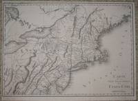
(Map / Chart of New England- USA): Carte De La Partie Septentrionale Des Etats_Unis
by Tardieu, P. F
- Used
- Condition
- Used
- Quantity Available
- 1
- Seller
-
Crozet, Virginia, United States
- Item Price
-
£435.77£6.99 shipping to USA
Show Details
Description:
Paris: Tardieu, 1802. VG+, b&w as issued. Scarce, detailed, with entire New England coastline from Delaware northward to Pasamaquody Bay, and streching westward to the eastern halves of Lake Huron and Lake Erie. Includes listings for Great and Little Egg Harbor, Martha's Vineyard, Cape Cod. A very handsome map with numerous waterway and topographical details, with place names of all major cities of the times, on excellent paper . The Tardieu's were a family of mapmakers from the mid-18th to early 19th century. Left margin a bit close. Measuring 14x19.75 inches (36x50cm). .
Item Price
£435.77
£6.99
shipping to USA
(Map / Chart of Eastern Canada- Hudson Bay, Newfoundland, Greenland, Labrador): La Baya D' Hudson Terra Di Labrador e Groenlandia Con Le Isole Adiacenti
by Zatta, Antonio
- Used
- Condition
- Used
- Quantity Available
- 1
- Seller
-
Crozet, Virginia, United States
- Item Price
-
£460.43£6.99 shipping to USA
Show Details
Description:
Venice: Antionio Zatta, 1778. Very good, early outline color with small decorative cartouche. The date is from the map plate, but this was published in 'Atlante Novissimo", which came out c. 1779. Zatta was a major Italian cartographer of the time, and his works are increasingly popular with collectors. This scarce copper-plate engraved map has very wide margins, and the image measures 11.5x16 inches. There is a quite a bit of coastal detail of Labrador, Neewfoundland and southern Greenland, but the central focus is on Hudson Bay, with available native American details noted. .
Item Price
£460.43
£6.99
shipping to USA
(Map / Chart of Eastern Canada- Hudson Bay, Newfoundland, Greenland, Labrador): La Baya D' Hudson Terra Di Labrador e Groenlandia Con Le Isole Adiacenti
by Zatta, Antonio
- Used
- Condition
- Used
- Quantity Available
- 1
- Seller
-
Crozet, Virginia, United States
- Item Price
-
£472.77£6.99 shipping to USA
Show Details
Description:
Venice: Antionio Zatta, 1778. Near fine, early outline color with small decorative cartouche. The date is from the map plate, but this was published in 'Atlante Novissimo", which came out c. 1779. Zatta was a major Italian cartographer of the time, and his works are increasingly popular with collectors. This scarce copper-plate engraved map has very wide margins, and the image measures 11.5x16 inches. There is a quite a bit of coastal detail of Labrador, Neewfoundland and southern Greenland, but the central focus is on Hudson Bay, with available native American details noted. .
Item Price
£472.77
£6.99
shipping to USA
(Map / Chart of Portugal): Regno Di Portogallo
by Zatta, Antonio
- Used
- Condition
- Used
- Quantity Available
- 1
- Seller
-
Crozet, Virginia, United States
- Item Price
-
£205.55£6.99 shipping to USA
Show Details
Description:
Venice: Antionio Zatta, 1775. Very good, early outline color with small decorative cartouche. Minimal marginal soiling. This is a very nice map Portugal, free of the usual combined image with Spain. The date is from the map plate, but this was published in 'Atlante Novissimo", which came out c. 1779. Zatta was a major Italian cartographer of the time, and his works are increasingly popular with collectors. This scarce copper-plate engraved map has very wide margins, and the image measures 11.5x16 inches. .
Item Price
£205.55
£6.99
shipping to USA
(Map / Chart- North & South America): Carte D'Amerique
by De L'Isle ( Delisle ), Guillaume
- Used
- Condition
- Used
- Quantity Available
- 1
- Seller
-
Crozet, Virginia, United States
- Item Price
-
£1,315.52£6.99 shipping to USA
Show Details
Description:
Paris: De L'Isle (Chez L'Auteur Sur le Quay de l'Horloge), 1722. Very good, heavy paper, early outline color. An increasingly uncommon early state (peninsular California) of this historically significant map of the Americas. The image extends eastward to the northwestern coast of Africa and Iberian peninsula. This map is well referenced (see Portinaro & Knirsch, 114). Guillaume De LiIsle was a pupil of JD Cassini (see the revised edition of Tooley's "Dictionary of Mapmakers", Map Collector Publications), and was a very prominent figure in French European Enlightenment cartography, known for his insitence on accuracy. Philippe Buache was his son-in-law. The attractive image measures 19x23 inches, with the right lower margin trimmed a bit close (about 1/4 inch outside neatiline)..
Item Price
£1,315.52
£6.99
shipping to USA
(Map / Chart of South Pacific Ocean): Pacific Ocean...to San Francisco and Easter Island (South East Sheet)
by Davies & Co. (Engravers for the Admiralty office)
- Used
- Hardcover
- first
- Condition
- Used
- Binding
- Hardcover
- Quantity Available
- 1
- Seller
-
Crozet, Virginia, United States
- Item Price
-
£123.33£6.99 shipping to USA
Show Details
Description:
London: Amiralty Office, 1907. Near fine, linen backed Admiralty chart, first published 31st Mach 1875, and corrected in Jan. 1882 and Nov. 1907. B&W as issued, with elaborate detail of the involved island archipelagos (including area of Tuamotu or Low Archipelago). This was the last of a 4 sheet chart of the Pacific Ocean beginning with the Philippine and Celebes Islands (others not present), and finishing with this sheet. The map image is 25x38 inches, folding into stiff maroon boards (labeled) measuring 10.5x10.5 inches. A very attractive chart. .
Item Price
£123.33
£6.99
shipping to USA

(Map / Chart- Environs of Vienna, Austria): Plan de la Ville De Vienne en Austriche et Ses Environs
by Jaillot, Alexis-Hubert
- Used
- Condition
- Used
- Quantity Available
- 1
- Seller
-
Crozet, Virginia, United States
- Item Price
-
£489.21£6.99 shipping to USA
Show Details
Description:
Paris: Jaillot, 1695. VG, with only flaw some dampstaining at lower margin with expert verso paper reinforcement, not affecting main image (would mat well). Centerfold as issued; hand-colored. A very uncommon and attractive plate, with a small walled city view (birds-eye) of Vienna, with all surrounding villages (castles) marked. A nice image of the Danube is central here. Jaillot was originally a sculptor (see Moreland & Bannister: Antique Maps). The copperplate image is 18x25.5 inches. .
Item Price
£489.21
£6.99
shipping to USA
(Map / Chart of Northern Hemisphere, Arctic, North Pole): Hemisphere Septentrional Pour Voir Plus Distinctement Les Teres Arctiques...1714
by DeLisle (De L'Isle, De Lisle), Guillaume
- Used
- Condition
- Used
- Quantity Available
- 1
- Seller
-
Crozet, Virginia, United States
- Item Price
-
£719.43£6.99 shipping to USA
Show Details
Description:
Paris: De L'Isle, 1718. VG with minimal edge browning and slight chipping. Early hand colored outlines. Hemispheric image is 18 inches in diameter, with peninsular California. This image shows a coastal connection between Greenland and the northern coast of Hudson Bay. Centerfold as issued. Probably the most talented map-maker of this remarkable family, Guillaume De L'Isle had drawn his first map by age 9, and was elected to the Royal Academy of Sciences by 27 (see Moreland & Bannister's 'Antique Maps'). The above date is approximate. This is a nice copy of an uncommon map, with N. America, Asia, northern Africa and northern S. America..
Item Price
£719.43
£6.99
shipping to USA
(Map / Chart of North and South America- California as an Island)): Recentissima Novi Orbis Sive Americae Septentrionalis et Meridionalis Tabula Per I. Danckerts..cum Privilegio
by Danckerts (Danckaerts,danckers, Danquerts), Justus
- Used
- first
- Condition
- Used
- Quantity Available
- 1
- Seller
-
Crozet, Virginia, United States
- Item Price
-
£2,302.16£6.99 shipping to USA
Show Details
Description:
Amsterdam: J. Danckerts, 1696. Very good, early color with minor archival verso repairs to centerfold (expert). This is a very decorative image of the Americas with the California as an island format, and a decorative cartouche of natives, serpents. It is no accident that the cartouche design and imagery on these maps strongly resemble those of the Blaeus, as Danckerts borrowed liberally from his predecessor. The Solomon Islands are shown to the west., as are the Cape Verde, Fortunate and Azores to the east. The Danckerts were a multigenerational and prominent mapmaking family in Amsterdam. This is plate 1 from an atlas, depicting the western hemisphere with elaborate detail for the times. Much of the southeastern USA is then labelled as Florida, with the Mare Virginicum and Canadium notations present. This uncommon and handsome image (map #2, vol. II of Koeman's 1st edition "Atlantes Neerlandici"), with minimal browning, measures 19x23 inches (49x58cm). .
Item Price
£2,302.16
£6.99
shipping to USA
(Map / Chart of South Pacific Ocean): Tuamotu (Paumotu) or Low Archipelago, Compiled from the Discoveries & Surveys of Cook, Kotzebue...Beechey...Wilkes...with Corrections from the French Chart of 1871
by Weller, Edward (engraver- for Admiralty office)
- Used
- Hardcover
- Condition
- Used
- Binding
- Hardcover
- Quantity Available
- 1
- Seller
-
Crozet, Virginia, United States
- Item Price
-
£123.33£6.99 shipping to USA
Show Details
Description:
London: Amiralty Office, 1898. Near fine, linen backed Admiralty chart, first published 10th Apr. 1872, and corrected in Nov. 1883 and April 1898. B&W as issued regarding doubtful existence and positions. 2 small spots left lower corner away from any major portion of image, and not casuing any serious visual distraction. The map image is 25x38 inches, folding into stiff maroon boards (labeled) measuring 10.5x10.5 inches. A very attractive chart. .
Item Price
£123.33
£6.99
shipping to USA
(Map / Chart- Europe, Asia- Roman Empire): Carte De L'Empire Romain
by Lapie
- Used
- Condition
- Used
- Quantity Available
- 1
- Seller
-
Crozet, Virginia, United States
- Item Price
-
£61.67£6.99 shipping to USA
Show Details
Description:
Paris: Chez Eymery Fruger et Cie., 1837. Very good condition, slight foxing at margins (very little visual impact), with orginal handcolored outlines. Very detailed depiction of the region of Europe and Asia, with the vast expanse of the Roman empire. The map is dated 1832, although it appeared in later atlas (above date approximate). The usual unobtrusive blindstamp is present. The map is from ATLAS UNIVERSEL DE GEOGRAPHIE ANCIENNE ET MODERNE. The image is 39x53cm (15.25x21 inches)..
Item Price
£61.67
£6.99
shipping to USA

(Map / Chart- Ottoman, Turkish Empire): Estats De L'Empire Du Grand Seigneur Des Turcs, En Europe, En Asie, et En Afrique, Divise En Touts Ses Beglerbeglicz, Ou Gouvernments
by Jaillot, Alexis-Hubert
- Used
- Condition
- Used
- Quantity Available
- 1
- Seller
-
Crozet, Virginia, United States
- Item Price
-
£986.64£6.99 shipping to USA
Show Details
Description:
Paris: H. Jaillot, 1695. VG, heavy paper, hand colored, decorative cartouche, inset of southern mediterranean / Algerian coast. A striking image, after Sanson and copied by several later cartographers. The above date is approximate, although clearly printed with the 5 scales indicated on the map.. Some browning and chipping of lower margin, not crossing neatline and easily covered by matting. This depicts the Ottoman (Turkish) Empire at the time, with its reaches through Asia, Europe and Africa. Includes environs of Mediterranean, Black, Red and Caspian Seas, with the "Golfe D'Ormus" at the western edge of the map. Includes details of Mediterranean with Cyprus, Rhodes, Candie, Sicily, Sardinia and Corsica, and much more. This is a very uncommon map, with the image measuring 18x25 inches (centerfold as issued)..
Item Price
£986.64
£6.99
shipping to USA
(Map / Chart of Scotland, Schetland Islands): Il Regno Di Scozia Di Nuova Projezione
by Zatta, Antonio
- Used
- Condition
- Used
- Quantity Available
- 1
- Seller
-
Crozet, Virginia, United States
- Item Price
-
£324.77£6.99 shipping to USA
Show Details
Description:
Venice: Antionio Zatta, 1776. Very good, early outline color with small decorative cartouche. Minimal lower margina paper defect. This is a very nice map of Scotland, with an attracive inset of the Schetland Islands. The date is from the map plate, but this was published in 'Atlante Novissimo", which came out c. 1779. Zatta was a major Italian cartographer of the time, and his works are increasingly popular with collectors. This scarce copper-plate engraved map has very wide margins, and the image measures 11.5x16 inches. .
Item Price
£324.77
£6.99
shipping to USA
(Map / Plan Louisbourg, Quebec, Halifax- Canada): Vorstellung...Nord-America...Plan...de Louisbourg...Plan De La Ville de Quebec...Plan of the Town of Halifax in Nova Scotia
by Homann Heirs
- Used
- Condition
- Used
- Quantity Available
- 1
- Seller
-
Crozet, Virginia, United States
- Item Price
-
£657.76£6.99 shipping to USA
Show Details
Description:
Nuremberg: Homann Heirs, 1756. VG+, faint offsetting, nice early color. The Halifax image occupies the whole lower half of this very attractive set of city views. Heavy paper, nice margins, with all 3 images very clean. This is plate No. 62 from this particular atlas.The full, large, handsome copperplate engraved image (all 3 views) measures 16.5x19.5 inches (42x50cm)..
Item Price
£657.76
£6.99
shipping to USA

Didn’t find what you’re looking for?
Try adding this search to your want list. Millions of books are added to our site everyday and when we find one that matches your search, we’ll send you an email. Best of all, it’s free.
Add to Want List

Are you a frequent reader or book collector?
Join the Bibliophile's Club and save 10% on every purchase, every day — up to $20 savings per order!

Social Responsibility
Did you know that since 2004, Biblio has used its profits to build 16 public libraries in rural villages of South America?
