Description:
[Amsterdam,: Jodocus Hondius, Cornelis Claesz., and Johannes Janssonius,, 1610].. 172 by 222mm. (6.75 by 8.75 inches).. Engraved map, Latin text on verso. First state of the plate, published in the second Latin edition of the pocket-sized Mercator-Hondius atlas, 'Atlas Minor de Gerardi Mercatoris
', 1610. 'Essentially copied from the map that appeared in the folio edition of the Mercator-Hondius atlas., although most of Korea is omitted and the bay of Suruga is significantly slimmer. This plate was used in further French, German and Latin editions until 1621. "Sometime after the edition of 1621 the plates were sold and taken to England where they were first used in the 1624 edition of 'Hakluytus Posthumus or Purchas His Pilgrimes'. As the plates were somewhat worn [by then], they were 'refreshed' by re-engraving the lettering and hachuring of the seas" (Hubbard). In 1570 Abraham Ortelius published the 'Theatrum Orbis Terrarum', the first collection of maps with a uniform size and style. It was an…
Read More Search Results: Titles starting with I from Daniel Crouch Rare Books Ltd
You searched for:
- Bookseller inventory: Daniel Crouch Rare Books Ltd (titles starting with I)
- Bookseller: Daniel Crouch Rare Books Ltd
Results 1 - 20 of 30

Iapan I.: From the first pocket-sized Mercator-Hondius atlas
by HONDIUS, Jodocus (I); CLAESZ., Corneslis, and JANSSONIUS, Johannes
- Used
- first
- Condition
- Used
- Quantity Available
- 1
- Seller
-
London, United Kingdom
- Item Price
-
£200.00£15.00 shipping to USA
Show Details
Item Price
£200.00
£15.00
shipping to USA

Iapan I.: From the first edition of 'Hakluytus Posthumus'
by HONDIUS, Jodocus (I) and PURCHAS, Samuel
- Used
- first
- Condition
- Used
- Quantity Available
- 1
- Seller
-
London, United Kingdom
- Item Price
-
£150.00£15.00 shipping to USA
Show Details
Description:
[London,: William Stansby for Henrie Featherstone,, 1624]. 316 by 198mm. (12.5 by 7.75 inches).. Engraved vignette map, set within English text. The second state of the plate, published here for the first time on page 413 in the first edition of 'Hakluytus Posthumus or Purchas His Pilgrimes', 1624. The map was previously published in the pocket-sized version of the Mercator-Hondius atlas from 1606 to 1621, after which the engraved plates were 'refreshed'. "Sometime after the edition of 1621 the plates were sold and taken to England where they were first used in the 1624 edition of 'Hakluytus Posthumus or Purchas his Pilgrimes'. As the plates were somewhat worn, they were 'refreshed' by re-engraving the lettering and the hachuring of the seas. This led, at least in the specific example of the map of Japan, to changes in the lettering of some place-names as the engraver probably did not have an example of an early print as a guide
[for example] the place-name 'Xima' (Shima) has been rendered 'Nuua' in…
Read More Item Price
£150.00
£15.00
shipping to USA

Iaponia.: Janssonius' new miniature edition of the Mercator-Hondius atlas
by JANSSONIUS, Johannes and KAERIUS, Petrus
- Used
- first
- Condition
- Used
- Quantity Available
- 1
- Seller
-
London, United Kingdom
- Item Price
-
£350.00£15.00 shipping to USA
Show Details
Description:
[Amsterdam,: Johannes Janssonius,, 1648].. 182 by 236mm. (7.25 by 9.25 inches).. Engraved map, German text on verso. Published in the second German edition (1648) of Janssonius' new edition of the miniature version of the Mercator-Hondius, 'Atlas Minor Gerardi Mercatoris a I. Honius pluri-mis aeneis Tabulis
'. This atlas was one of a series launched by Janssonius "before he joined forces with Henricu Hondius in 1629, filling the gap left by the sale of the copperplates for the 'Atlas Minor' sometime after 1621, and taken to England where they were first used in the 1624 edition of 'Hakluytus Posthumus or Purchas His Pilgrimes. The new Janssonius maps were engraved by Pieter van den Keere (Petrus Kaerius). The maps were slightly larger than those in Hondius' 'Atlas Minor'" (Hubbard). The first edition appeared with Latin text in 1628, followed by a French edition in 1630, a Dutch edition also in 1630, two German editions in 1631 and 1648, and a further Latin edition in 1634. The map is a direct…
Read More Item Price
£350.00
£15.00
shipping to USA
More Photos
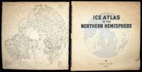
Ice Atlas of the Northern Hemisphere.
by U.S. NAVY
- Used
- Hardcover
- Signed
- Condition
- Used
- Binding
- Hardcover
- Quantity Available
- 1
- Seller
-
London, United Kingdom
- Item Price
-
£2,000.00£15.00 shipping to USA
Show Details
Description:
Washington D.C.,: United States Hydrographic Office,, 1946.. Arctic Ice Atlas Large folio (625 by 640mm), index chart as front pastedown, title, preface signed by George S. Bryan, Rear Admiral, 86 full and half-page chromolithographed maps and charts, divisional titles, tables, bibliography; original ring-bound pictorial blind-stamped black cloth binding, gilt title. Arctic exploration reached new heights in the early twentieth century with the first successful expedition to the North Pole. Throughout the following decades, countries started to claim territorial rights in the Artic for economic, industrial and above all military reasons. In the Second World War, the Arctic region became a key supply route for then-allies the United States and the USSR. Naturally, its strategic importance only increased during the Cold War. In 1946, the US Navy published an atlas of the northern hemisphere documenting the extent of and changes to the ice formation across the Arctic. Coloured monthly maps for each…
Read More Item Price
£2,000.00
£15.00
shipping to USA

Il disegno della terza parte dell'Asia.: Gastaldi's seminal map of Southeast Asia
by GASTALDI, Giacomo, FORLANI, Paolo & BERTELLI, Ferrando
- Used
- Condition
- Used
- Quantity Available
- 1
- Seller
-
London, United Kingdom
- Item Price
-
£125,000.00£15.00 shipping to USA
Show Details
Description:
[Venice,, 1562 and c1568].. 680 by 775mm. (26.75 by 30.5 inches).. Engraved map on three sheets joined, bearing three watermarks, upper left sheet with ladder in shield under cross pommy B (Woodward 256), upper right with lamb, paschal with straight standard C (Woodward 48), lower sheet, only lower half of ladder in shield under six-pointed star K (Woodward 253). A fine example of Gastaldi's map Southeast Asia, the most influential map of the region published in the sixteenth century, and the first map to name Singapore; here present with the rare southern extension sheet, incorporating the Java and the lucrative Spice Islands. Giacomo Gastaldi (c1500-1567), originally from Piedmont, established himself as a cartographer in Venice, where he was given the notable title of 'Cosmographer to the Republic'. He was a prolific mapmaker, with a body of work numbering at least 109 pieces, including contributions to the 1548 Venice edition of Ptolemy's 'Geogra a', and Ramusio's 'Navigationi et viaggi'.…
Read More Item Price
£125,000.00
£15.00
shipping to USA
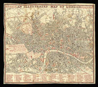
An Illustrated Map of London.: Rare map of London printed on cloth
by [ANONYMOUS]
- Used
- Hardcover
- Condition
- Used
- Binding
- Hardcover
- Quantity Available
- 1
- Seller
-
London, United Kingdom
- Item Price
-
£1,200.00£15.00 shipping to USA
Show Details
Description:
[?London,, c1855].. 510 by 590mm (20 by 23.25 inches).. Engraved plan, printed in red and black, on cloth, key to plan below. Rare map of London printed on cloth. The plan is printed in red and black. All bridges, railways, public buildings, squares, parks, and borough names are printed in red. To the left and right of the title is a note: "Below is a List of the chief Sights & Amusements of London and it's Environs, worthy of notice. The Star denotes free admittance. The Figures on the left refer to the map, on the right, the distance in miles from London." Although the plan is not dated, we can assign a date of around 1855: it depicts both Holloway Prison ('Model Prison'), opened in 1852, and the Metropolitan Cattle Market ('New Cattle Market') opened in 1855. Strangely the plan fails to show King's Cross Station which was opened in 1852. Not in Hyde.
Item Price
£1,200.00
£15.00
shipping to USA

Imperio del Giappone: Italian map of Japan
by KAEMPFER, Engelbert; TIRION, Isaak; ALBRIZZI, Giovanni Battista and DE L'ISLE, Guillaume
- Used
- Condition
- Used
- Quantity Available
- 1
- Seller
-
London, United Kingdom
- Item Price
-
£500.00£15.00 shipping to USA
Show Details
Description:
[Venice,: Giovanni Battista Albrizzi,, 1740].. 365 by 502mm. (14.25 by 19.75 inches).. Engraved map. The third state of the map, with the title changed to 'Imperio del Giappone' and published in Albrizzi's 'Atlante Novissimo'. Albrizzi (1698-1777) began to publish Salmon's 'Modern History
or, the present State of all Nations', 'Lo Stato Presente Di Tutti Paesi E Popoli Del Mondo' in 1731, when he issued volume one. The second volume "containing the map of Japan was published only in 1734. By 1738, the popularity of the work forced him into publishing a second edition, probably having exhausted the initial volumes. He continued to add volumes up to a least 1762, by which time he had issued a volume 26" (Hubbard). The map of Japan was a copy of Tirion's version of Kaempfer's map, probably engraved by Giuseppe Filosi (fl1732-1757), with only the title and the names of the seas and major features changed into Italian. The map retains Tirion's mistakes and has inadvertently joined 'Jesso of…
Read More Item Price
£500.00
£15.00
shipping to USA

Impero del Giappone: A map of Japan from Benedetto Marzolla's 'Atlante geografico' Questa Carta e stata eseguita su quella pubblicata in Londra nel 1835, dalla Societa per la diffusione delle utili conoscenze, e su quella di Arrowsmith; e fa parte del l'Atlante Geografico che
by MARZOLLA, Benedetto after the Society for the Diffusion of Useful Knowledge and ARROWSMITH, Aaron
- Used
- Condition
- Used
- Quantity Available
- 1
- Seller
-
London, United Kingdom
- Item Price
-
£150.00£15.00 shipping to USA
Show Details
Description:
Naples,: Benedetto Marzolla., 1847.. 673 by 516mm. (26.5 by 20.25 inches).. Lithographed map with notes and statistical tables, dissected and laid on linen, original hand colour. A map of Japan from Benedetto Marzolla's unusual and scarce atlas, the "Atlante geografico". The note in the title cartouche acknowledges the debt of the mapmaker to both Aaron Arrowsmith and the Society for the Diffusion of Useful Knowledge. Benedetto Marzolla (1801-1858) was an Italian soldier and cartographer. He was a lieutenant engineer in the Neapolitan army and ran his own lithography business. Each of the maps in his atlas, as here, is accompanied by extensive notes on the country shown and acknowledgements of the cartographers whose work he had used.
Item Price
£150.00
£15.00
shipping to USA

Impero del Giappone: From Benedetto Marzolla's "Atlante geografico" Questa Carta e stata eseguita su quella pubblicata in Londra nel 1835, dalla Societa per la diffusione delle utili conoscenze, e su quella di Arrowsmith; e fa parte del l'Atlante Geografico che si pubblica da
by MARZOLLA, Benedetto after the Society for the Diffusion of Useful Knowledge and ARROWSMITH, Aaron
- Used
- Condition
- Used
- Quantity Available
- 1
- Seller
-
London, United Kingdom
- Item Price
-
£135.00£15.00 shipping to USA
Show Details
Description:
Naples,: Benedetto Marzolla., 1847.. 693 by 525mm. (27.25 by 20.75 inches).. Lithographed map with notes and statistical tables. A map of Japan from Benedetto Marzolla's unusual and scarce atlas, the "Atlante geografico". The note in the title cartouche acknowledges the debt of the mapmaker to both Aaron Arrowsmith and the Society for the Diffusion of Useful Knowledge. Benedetto Marzolla (1801-1858) was an Italian soldier and cartographer. He was a lieutenant engineer in the Neapolitan army and ran his own lithography business. Each of the maps in his atlas, as here, is accompanied by extensive notes on the country shown and acknowledgements of the cartographers whose work he had used.
Item Price
£135.00
£15.00
shipping to USA

More Photos
In hoc Operae haec continétur Geographia Cl. Ptholemaei a plurimis uiris utriusqß. linguae doctiss. emendata:& cum Archetypo graeco ab ipsis collata...: The earliest obtainable printed depiction of the Americas
by PTOLEMAEUS, Claudius
- Used
- Hardcover
- Condition
- Used
- Binding
- Hardcover
- Quantity Available
- 1
- Seller
-
London, United Kingdom
- Item Price
-
£500,000.00£15.00 shipping to USA
Show Details
Description:
Rome,: [Colophon:] Explicat Planisphaerium Ptholemai recognitum diligentissime a Marco Beneventano Monacho Caelestinorum quod antea in multis etia antiquis exemplaribus latinus corruptissimum reperiebantur. Nec nõ Claudii Ptholemai a plurimis uiris utriusqß linguae doctiss. emendatu cum multis additionibus Rome Novitur impressum per Bernadinu Venetu de Vitalibus. Expesis Evagelista Tossino Brixiano Bibliopola. Impante Iulio II. Pont. Max Anno. III. Potificatus sui Die VIII. Septebr M.D.VII., 1507.. Folio (403 by 275mm). 200 leaves, one of which is blank, comprising letterpress title, index, and text in double columns with 52 lines to a full column on 107 leaves, followed by one blank leaf, ornamental initials and woodcut diagrams in the text and full page woodcut "Sphaero in plano" on N1 recto, 6 leaves (of 14 of the "orbis nova descriptio" by Beneventanus normally found in the fourth (1508) edition), 34 double-page copper engraved maps on 68 leaves (one folding), and the treatise "De Locis" in 20…
Read More Item Price
£500,000.00
£15.00
shipping to USA

In which is Expressed all the Roads, Lanes, Churches, Noblemen, and Gentlemen's Seats, &c. &c., the Principal Observations, by the Late John Rocque, Topographer to HIs Majesty, Compleated and Engraved by Peter Andrews. To His Royal Highness William Henry Duke of Gloucester & Edinburgh and Earl of Connaught Ireland. This Actual Survey of the County of Surrey in most humbly inscrib'd by his Royal Highness's most humble and obliged Servant. Mary Ann Rocque.
by ROCQUE, John
- Used
- Condition
- Used
- Quantity Available
- 1
- Seller
-
London, United Kingdom
- Item Price
-
£2,500.00£15.00 shipping to USA
Show Details
Description:
London,: Mary Ann Rocque,, [c1765].. 570 by 700mm (22.5 by 27.5 inches).. Maps,""A Topographical Map of the County of Surrey The first large scale survey of Surrey Engraved map, ???? in 9 double-page sheets. The first state of John Rocque's immensely detailed map of Surrey, identifiable by the omission of the Battersea and Richmond Bridges. The contribution of the Huguenot surveyor and engraver John Rocque (d1762) to English regional cartography is difficult to overstate. He produced fine surveys of Berkshire, Middlesex, Shropshire and Surrey, together with two important maps of London. The Surrey map is no exception - the first of the county on this scale. Following Rocque's death in 1762 the survey was completed and the plates engraved by Peter Andrews, but it retains Rocque's unique style, suggesting that most of the survey was finished before his death. It was published by his widow, Mary Ann Rocque, who inherited the business upon Rocque's death and ran it successfully for some time after: the…
Read More Item Price
£2,500.00
£15.00
shipping to USA

Indian Archipelago: Bartholomew's Southeast Asia
by BARTHOLOMEW, J.
- Used
- Condition
- Used
- Quantity Available
- 1
- Seller
-
London, United Kingdom
- Item Price
-
£150.00£15.00 shipping to USA
Show Details
Description:
London,: A. Fullarton,, [1858]. 470 by 585mm. (18.5 by 23 inches).. Hand-coloured engraved map. Map of the Indonesian Archipelago showing Dutch territorial possessions.
Item Price
£150.00
£15.00
shipping to USA
![Indie Moet Vrij! [The Indies Shall Be Freed!]](https://d3525k1ryd2155.cloudfront.net/h/874/909/1162909874.0.m.jpg)
Indie Moet Vrij! [The Indies Shall Be Freed!]: The Indies Shall Be Freed!
by KEELY, Patrick Cokayne
- Used
- Condition
- Used
- Quantity Available
- 1
- Seller
-
London, United Kingdom
- Item Price
-
£2,500.00£15.00 shipping to USA
Show Details
Description:
London,: Published by James Haworth and Brother Ltd., [c1944].. 730 by 500mm (28.75 by 19.75 inches).. Chromolithograph map. The Dutch title to this war-time poster reads 'Indie Moet Vrij!' (The Indies Shall be Freed!). The poster, published in London towards the end of the Second World War was evidently aimed at the Free Dutch troops still station in Britain at the time, the Dutch East Indies having fallen under control of the Japanese Imperial Army. The theatre had been somewhat by-passed by the Allied powers who had decided not to occupy Sumatra but focus their efforts on Japan itself. In this light the post may be seen as a sop to the Dutch who may well have felt that their colonies had been ignored by their allies. Maps depicting Octopi have a long a distinguished history. The Octopus was most famously used by Fred Rose, who in 1870 depicted Russia as a malignant Octopus, its malignant tentacles spreading across the map. The device would be used by the Japanese during the Russo-Japanese War of…
Read More Item Price
£2,500.00
£15.00
shipping to USA

More Photos
Institution Astronomique de l'usage des globes et spheres...: Blaeu's user's manual for globes, spheres and sundials
by BLAEU, Willem
- Used
- Hardcover
- Condition
- Used
- Binding
- Hardcover
- Quantity Available
- 1
- Seller
-
London, United Kingdom
- Item Price
-
£4,000.00£15.00 shipping to USA
Show Details
Description:
Amsterdam,: Joan and Cornelis Blaeu,, 1642.. 4to. (205 by 160mm), [9] ff. 277pp., numerous diagrams and woodcut illustrations within text, contemporary marginalia to title and a few leaves, some light dampstaining, final leaf with lower part cut off, contemporary vellum, title in manuscript to spine. Scarce first French edition of the great cartographer's handbook to his famous globes and spheres, published by his sons Joan and Cornelis. The master globe-maker, who had recently produced the largest globes in the world to date (68 cm in diameter), authored the Institution Astronomique so that his customers might get the most out of their celestial and terrestrial globes. Blaeu gives a detailed explanation of the various parts of a globe, followed by a series of nearly 150 exercises. By positioning your terrestrial globe as Blaeu directs, it is a simple matter to determine the time in different parts of the world, or to ascertain the length of a day in your hometown of Amsterdam at any given season.…
Read More Item Price
£4,000.00
£15.00
shipping to USA

More Photos
Institutio astronomica de usu globorum & sphaerarum caelestium ac terrestrium...: Blaeu's user's manual for globes, spheres and sundials
by BLAEU, Willem
- Used
- Hardcover
- Condition
- Used
- Binding
- Hardcover
- Quantity Available
- 1
- Seller
-
London, United Kingdom
- Item Price
-
£4,000.00£15.00 shipping to USA
Show Details
Description:
Amsterdam,: Joan Blaeu,, 1652.. 4to. (190 by 120mm) [8]ff., 246pp., numerous diagrams and woodcut illustrations within text, contemporary vellum over boards. Latin edition of the great cartographer's handbook to his famous globes and spheres, published by his son Joan. The master globe-maker, who had recently produced the largest globes in the world to date (68 cm in diameter), authoured the Institutio astronomica so that his customers might get the most out of their celestial and terrestrial globes. Blaeu gives a detailed explanation of the various parts of a globe, followed by a series of nearly 150 exercises. By positioning your terrestrial globe as Blaeu directs, it is a simple matter to determine the time in different parts of the world, or to ascertain the length of a day in your hometown of Amsterdam at any given season. There are exercises for both the celestial sphere concerning the ascendancy of certain constellations and the terrestrial globe locating a town in Indonesia given its…
Read More Item Price
£4,000.00
£15.00
shipping to USA

Insularum Iaponiae: A German copy of Sanson's map in VII Partes divisa & LXVI Regna Antiqua divise per N Sanson.
by ZUNNER, Johann David after SANSON D'ABBEVILLE, Nicolas (I)
- Used
- Condition
- Used
- Quantity Available
- 1
- Seller
-
London, United Kingdom
- Item Price
-
£300.00£15.00 shipping to USA
Show Details
Description:
[Frankfurt,: Johann David Zunner, , 1679].. 233 by 302mm. (9.25 by 12 inches).. Engraved map. Johann David Zunner's version of Nicolas Sanson d'Abbeville's map of Japan. The map was produced by Zunner for his 'Die gantze Erd=Kugel, Bestehend In den vier bekannten Theilen der Welt, Als Europa, Asia, Africa und America' (1679). It is a faithful copy of Sanson's map from 'L'Asie en plusiers cartes nouvelles, et exactes'. Zunner gives full credit to Sanson on the title-page and on the map. Johann David Zunner (1641-1704) was a German publisher active in Frankfurt. Hubbard 42.
Item Price
£300.00
£15.00
shipping to USA
![Invented & Drawed [sic] by De la Joue](https://d3525k1ryd2155.cloudfront.net/h/993/597/1456597993.0.m.jpg)
Invented & Drawed [sic] by De la Joue
by ROCQUE, John and Bartholomew ROCQUE (engraver)
- Used
- Condition
- Used
- Quantity Available
- 1
- Seller
-
London, United Kingdom
- Item Price
-
£2,000.00£15.00 shipping to USA
Show Details
Description:
St. James's,: J: Rocque at the Cannister & Sugar Loaf in Great Windmill Street, , 1737.. 180 by 130mm (7 by 5 inches).. Prints,""A Book of Ornaments, Advertising an unpublished book of rococo ornaments Engraved trade card. Advertisement for an apparently unpublished English collection of Jacque de La Joue the younger's designs for rococo ornaments. Embellished with an elaborate asymmetrical rococo cartouche typical of the genre, engraved by John Rocque's brother Bartholomew, who was better known as a horticulturist and landscape gardener based in Walham Green, Fulham. John Rocque, used many such devices in his maps, and sold at least one other book of ornaments, by Italian artist Gaetano Brunitti, from his premises in London and Dublin. La Joue (1686-1761) was the son of a master mason, and well known as a designer and painter of decorative ornament and architecture. He was received into the """"Académie Royale de Peinture et de Sculpture on presentation of two imaginary architectural views in 1721…
Read More Item Price
£2,000.00
£15.00
shipping to USA
![[Invoice]](https://d3525k1ryd2155.cloudfront.net/h/361/910/1162910361.0.m.jpg)
[Invoice]: Rare Invoice of a Wapping chartseller
by WATSON, Michael
- Used
- Condition
- Used
- Quantity Available
- 1
- Seller
-
London, United Kingdom
- Item Price
-
£450.00£15.00 shipping to USA
Show Details
Description:
London,: 340 Wapping, near the Hermitage Stairs,, 1845.. Invoice with engraved header. An invoice from Michael Watson, "Stationer, Book & Chart Seller", at 340 Wapping, near the Hermitage Stairs, for the supply of a log book and other items to Captain Weare of the barque "Albion". Michael Watson was the "General and Twopenny Post Receiver" in Wapping from 1805 until after 1849. His handwritten receipt has a printed header including his name and address as well a female maritime figure seated upon an anchor with ships in the background. A rare ephemeral survival.
Item Price
£450.00
£15.00
shipping to USA

Ireland according to the latest Improvements: There are two known composite atlases, compiled around 1721 and 1790, which contain the map of Ireland.
by [PARKER, Samuel], attributed to
- Used
- Condition
- Used
- Quantity Available
- 1
- Seller
-
London, United Kingdom
- Item Price
-
£2,500.00£15.00 shipping to USA
Show Details
Description:
London, : George Willdey, , [c1710].. Engraved map with fine original hand-colour in outline, minor nicks to left and lower margin. A rare map of Ireland with a unique design. George Willdey (?1671-1737) was a flamboyant London shopkeeper and self-publicist. His principal business was as a toy-man and seller of luxury goods, jewellery, gold and silver trinkets, and china. However, he was perhaps the first mapseller to widen the appeal of maps from an intellectual elite to the general public; the interesting shape and 'fun facts' on the present example show his attempts to broaden their appeal. Willdey's map of Ireland was part of a series of separately issued maps showing countries across Europe, as well as London, Oxford and Cambridge. This series is most commonly attributed to Samuel Parker, on the grounds that the map of England and Wales bears his signature, and several other maps show his distinctive style. All of these maps are formatted in the same unique way, with the central image…
Read More Item Price
£2,500.00
£15.00
shipping to USA

Ironmongers Hall with a View of Fenchurch Street.: Ironmongers' Hall
by BOWLES, T[homas] after DONAWELL, I.
- Used
- Condition
- Used
- Quantity Available
- 1
- Seller
-
London, United Kingdom
- Item Price
-
£450.00£15.00 shipping to USA
Show Details
Description:
[London,, 1750-3].. Image: 235 by 405mm (9.25 by 16 inches). Sheet: 250 by 410mm (9.75 by 16.25 inches).. Etching and engraving. A perspective print of Ironmonger's Hall. A 'perspective' print was designed to be viewed "through a double convex lens which gives the illusion of depth", and normally showed architecture or formal gardens that could be drawn with straight lines converging to a vanishing point (V&A). The lens was sometimes mounted with a mirror so prints could be viewed while flat. Perspective prints were available throughout the eighteenth century and early in the nineteenth centuries although the period of their greatest popularity was c1740 to 1790. The fashion for these prints was international, and prints were often issued, as in this example, with captions in multiple languages. The publication details have been trimmed from the print. The British Library has a copy printed for "Tho. Bowles in St. Pauls Church Yard. John Bowles and Son in Cornhill, R Sayer in Fleet Street, and H…
Read More Item Price
£450.00
£15.00
shipping to USA

Didn’t find what you’re looking for?
Try adding this search to your want list. Millions of books are added to our site everyday and when we find one that matches your search, we’ll send you an email. Best of all, it’s free.
Add to Want List

Are you a frequent reader or book collector?
Join the Bibliophile's Club and save 10% on every purchase, every day — up to $20 savings per order!

Social Responsibility
Did you know that since 2004, Biblio has used its profits to build 16 public libraries in rural villages of South America?
