Description:
Paris: Garnier Freres, 1880. Very good, hand colored outlines, later Malte-Brun map from "Atlas de Geographie Universelle...". The above date is approximate. The attractive image measures 8.75x12 inches..
Search Results: Titles starting with H from The Prime Meridian: Antique Maps & Books
You searched for:
- Bookseller inventory: The Prime Meridian: Antique Maps & Books (titles starting with H)
- Bookseller: The Prime Meridian: Antique Maps & Books
Results 1 - 20 of 25

(Historical Map of Poland- 18th & 19th Century): Carte Historique De La Pologne...en 1772, 1794, 1795, 1807, et 1815
by Malte-Brun (JJN Huot)
- Used
- Condition
- Used
- Quantity Available
- 1
- Seller
-
Crozet, Virginia, United States
- Item Price
-
£52.87£6.91 shipping to USA
Show Details
Item Price
£52.87
£6.91
shipping to USA
(Historical Map of England, Ireland, Central Europe, Switzerland,France- Royal Houses): Carte Pour L'Intelligence De L'Histoire D'Angleterre...Remarque Les Conquestes De Cette Monarchie...Monarchie Francois
by Chatelain, Henri
- Used
- Condition
- Used
- Quantity Available
- 1
- Seller
-
Crozet, Virginia, United States
- Item Price
-
£158.61£6.91 shipping to USA
Show Details
Description:
Amsterdam: Chez Freres Chatelain Libraries , 1708. VG engraving, detailing the interrelationships of the English (Richard II-Henri II) and French (Anne-James I) and more, with family trees showing the ties. The map image includes most of France, England and Ireland, Switzerland, and much of Germany, with an inset into regions ruled in the environs of the Mediterranean (east to Cyprus). As expected, the text is in French. This is from Tome III (vol. 3) of Chatelain's wonderful "Atlas Historique" (the first atlas to bear this name). The handsome engraved double-page image with surrounding text mesures 18.5x24.5 inches; the central map image measures 10.5x10.5 inches..
Item Price
£158.61
£6.91
shipping to USA
(Historical Chart of Spain- Kings): Carte Cronologique et Historique Pour Servir a L'Histoire D'Espagne
by Chatelain, Henri
- Used
- Condition
- Used
- Quantity Available
- 1
- Seller
-
Crozet, Virginia, United States
- Item Price
-
£122.01£6.91 shipping to USA
Show Details
Description:
Amsterdam: Chez Francois L'Honore & Compagnie, 1705. VG engraving, b&w as issued, with some general browning. A very handsomeplate with many small busts depicting the Kings of Spain (including Portugal and various regions at the time). This is from Tome I (vol. 1) of Chatelain's wonderful "Atlas Historique". The engraved double-page image 114x17 inches..
Item Price
£122.01
£6.91
shipping to USA
(Historical Map of Environs of the Danube River): Carte Ancienne Eet Moderne Des Differents Etats et Pais Situez Au Long Du Danube
by Chatelain, Henri
- Used
- Condition
- Used
- Quantity Available
- 1
- Seller
-
Crozet, Virginia, United States
- Item Price
-
£158.61£6.91 shipping to USA
Show Details
Description:
Amsterdam: Chez Freres Chatelain Libraries, 1708. VG+ engraving, b&w as issued. A very attractive and interesting map detailing major principalities along the Danube, broken into ancient and modern place-names, with extensive textual remarks on the history. This is from Tome II (vol. 2) of Chatelain's wonderful "Atlas Historique". The engraved double-page image with surrounding text mesures 14x17 inches; the map is 9.5x12.5 inches..
Item Price
£158.61
£6.91
shipping to USA
(Historical Atlas - Pre- Persian Wars, Orient, 24 maps): Atlas D'Histoire Ancienne De L'Orient Anterieurement Aux Guerres Mediques
by Lenormant, Francois
- Used
- Hardcover
- first
- Condition
- Used
- Edition
- First Edition
- Binding
- Hardcover
- Quantity Available
- 1
- Seller
-
Crozet, Virginia, United States
- Item Price
-
£427.04£6.91 shipping to USA
Show Details
Description:
Paris: A. Levy (Rue De Seine, 29), 1868. This is a 13 inch folio. All 24 lithographed maps present, generally in very good or better condition. Original heavy paper boards with remnants of original ties. Edges of spine a bit chipped and split, upper edges of boards a bit dampstained, but title completely legible. A small ex-libris stamp is on the front cover (Libreria Estrangera de A. Vedauger..Barcelona). Lenormant was a notable scholar, publishing his first article by age 14 in an archeological review. He made several long sojourns through the east, resulting in the popular "Manuel d'histoire ancienne de l'Orient jusqu'aux guerres Mediques" (Paris 1868). The atlas here seems to be related to that work, and the date is approximate (same publisher). He became a distinguised lecturer on Greek and Eastern antiquities, having in 1874 been promoted to professor of archaeology at the Bibliotheque Nationale. He was profusely published, and this atlas is a very uncommon volume. Several…
Read More Item Price
£427.04
£6.91
shipping to USA
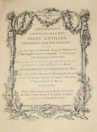
(History of Cartography, Geographic description of the Antilles): Description geographique des isles Antilles possédées par les Anglois
by Bellin, Jacques Nicolas
- Used
- very good
- Hardcover
- first
- Condition
- Used - Very Good
- Edition
- First Edition
- Binding
- Hardcover
- Quantity Available
- 1
- Seller
-
Crozet, Virginia, United States
- Item Price
-
£6,161.50£6.91 shipping to USA
Show Details
Description:
A Paris: De l'imprimerie de Didot, 1758. This 10.5 inch quarto is in very good condition, sound hinges, 171 pp. with all 22 maps (several folding), plans and views in very good or better condition on heavy paper. Contemporary calf boards with original marbeled pastedowns, two title pages (one decorative with attribution to Bellin), "Tables des Titres" and "Table des Cartes, Plans et Vues." Six compartment, banded spine, with red, gilt title label.Triple (French), gilt fillets on front and rear boards. Bellin was the first chief hydrographic engineer of the French Hydrographic Office (see Tooley's Dictionary of Mapmakers, revised ed.). Ref: Beinecke, Lesser Antilles Collection, 215; Sabin 4553. This is an extremely nice copy.. First Edition. Full-Leather. Very Good.
Item Price
£6,161.50
£6.91
shipping to USA
(History of Cartography): Historical Atlas of the Pacific Northwest
by Hayes, Derek
- Used
- as new
- Hardcover
- first
- Condition
- As New
- Edition
- First Edition
- Binding
- Hardcover
- Quantity Available
- 1
- Seller
-
Crozet, Virginia, United States
- Item Price
-
£32.54£6.91 shipping to USA
Show Details
Description:
Seattle: Sasquatch Books, 1999. As new copy of the first edition this wonderful recent production, already increasingly difficult to find. Hard to beat this quality for the price. This has already received rave reviews from several sources, and reproduces 320 maps over four centuries (ranging from Sir Francis Drake's 1579 voyages through the Klondike goldrush and Canadian Pacific Railways maps/surveys). Includes index and individual map references. This will be a classic (in a hurry). There are a few small edge tears (tiny) to the jacket due to shelfwear.. First Edition. Cloth. As New/As New. Folio - over 12" - 15" tall.
Item Price
£32.54
£6.91
shipping to USA
(History of Cartography): The Shaping of Vermont. From the Wilderness to the Centennial 1749-1877
by Graffagnino, J. Kevin
- Used
- very good
- Hardcover
- first
- Condition
- Used - Very Good
- Edition
- First Edition
- Binding
- Hardcover
- Quantity Available
- 1
- Seller
-
Crozet, Virginia, United States
- Item Price
-
£158.61£6.91 shipping to USA
Show Details
Description:
Rutland: Vermont Heritage Press, 1983. This is a small elephant folio (15.75 inches), with the green cloth boards in very good condition, internally clean, with a tight binding. The DJ is present, but with several marginal tears, and a longer tear at the spine. xxxii, 148 pp. This does not have a map portfolio, but is loaded with maps, portraits and manuscript reproductions (in b&w). This is a fine piece of New England history, with a nice bibliography, and increasingly uncommon.. First Edition. Cloth. Very Good/Fair.
Item Price
£158.61
£6.91
shipping to USA
(History of Cartography - Portolan Charts) The Nautical Chart of 1424 and the Early Discovery and Cartographical Representation of America. A Study on the History of Early Navigation and Cartography
by Cortesao, Armando (translator)
- Used
- Hardcover
- Signed
- Condition
- Used
- Edition
- Limited/Numbered
- Binding
- Hardcover
- Quantity Available
- 1
- Seller
-
Crozet, Virginia, United States
- Item Price
-
£589.72£6.91 shipping to USA
Show Details
Description:
Portugal: University of Coimbra, 1954. Signed by Author This is in an unusual format, with the original soft covers (not the later leather binding), as issued, with book interior in excellent shape. The dedication page to Philip Ramsay Robinson is present. Neat, pencilled owners signature on front end-paper. The stiff paper boards with title and crest are a bit browned, with the edges slightly chipped. SIGNED BY AUTHOR; limited edition #324; publishers gift copy with small library stamp of Catholic University of America on title page (no other library markings). Binding sound. Introduction and discussion in English by this major cartographic historian. There are reproductions of several early portolan charts, plus the exhaustive 110 pp text and the seprate bibliography and index (pp 113-123; uncut in this section). This chart was apparently first catalogued and discussed in detail here, and had been found with the breakup of the collection of Sir Thomas Phillipps ("Biblioteca Phillippica"…
Read More Item Price
£589.72
£6.91
shipping to USA
(History of Cartography): Lewis Evans His Map of the Middle British Colonies in America: A Comparative Account of Ten Different Editions Published Between 1755 and 1807
by Stevens, Henry N
- Used
- very good
- Hardcover
- first
- Condition
- Used - Very Good
- Edition
- First Edition
- Binding
- Hardcover
- Quantity Available
- 1
- Seller
-
Crozet, Virginia, United States
- Item Price
-
£305.02£6.91 shipping to USA
Show Details
Description:
London: Henry Stevens, Son and Stiles, 39 Great Russell Street Over Against the South-West Corner of the British Museum, 1905. Overall very good copy in original stiff paper boards, with Chiswick Press colophon towards rear of book. 41 pp., 8.75 inch octavo, with some chipping to edge of upper spine. Covers minimally soiled. This small reference monograph is increasingly difficult to find.. First Edition. Stiff Paper. Very Good. 8vo.
Item Price
£305.02
£6.91
shipping to USA
(History of Cartography, USA): The Southeast in Early Maps with an annotated checklist of printed and manuscript regional and local maps of southeastern north America
by Cumming, William P
- Used
- first
- Condition
- Used
- Edition
- First Edition
- Quantity Available
- 1
- Seller
-
Crozet, Virginia, United States
- Item Price
-
£178.95£6.91 shipping to USA
Show Details
Description:
Princeton (NJ): Princeton University Press, 1958. Eleven inch 4to, very good, with good DJ (few chips at spine ends of DJ only). Binding tight. 1x, 275 pp with index and map list. This is the first edition of this classic. Owner's signature dated 1958, in ink, on front pastedown. This is a hard-to-find item as a first edition, and is a classic in the history of cartography of the region. The list begins with the 1544 De Soto map, and ends in 1775 with the Fry-Jefferson and Mouzon maps.. First Edition.
Item Price
£178.95
£6.91
shipping to USA
(History, Cartography, Facsimile): The John Henry County Map of Virginia 1770
by Wright, Louis B. (introduction by)
- Used
- Hardcover
- Condition
- Used
- Edition
- Limited
- Binding
- Hardcover
- Quantity Available
- 1
- Seller
-
Crozet, Virginia, United States
- Item Price
-
£345.70£6.91 shipping to USA
Show Details
Description:
Charlottesville: University of Virginia Press , 1977. Fourteen inch folio in orginal brown, gilt-lettered slipcase, produced as a limited (unnumbered) edition of 500. Wright's introduction is nicely referenced, and the four loose maps sheets are all present. In spite of numerous criticisms (including those of Thomas Pownall), this is a major piece of Virginia cartographic history, as it was the first map to show the county boundaries within the state. Henry (Patrick Henry's father) was hoping his efforts would provide a greater monetary reward than they did, but the bad press dashed those hopes.Still, the map provided important social and economic information, and its deficiencies are perhaps no more severe than other contemporary maps. This is an uncommon facsimile production, in excellent condition (the interior has seen very little use, and the slipcase is remarkably clean, with only slight fading towards the open end).. Limited. Cloth.
Item Price
£345.70
£6.91
shipping to USA
(History of Cartography): Monarchs Ministers and Maps. The Emergence of Cartography as a Tool of Government in Early Modern Europe
by Buisseret, David (editor)
- Used
- as new
- Hardcover
- first
- Condition
- As New
- Edition
- First Edition
- Binding
- Hardcover
- Quantity Available
- 1
- Seller
-
Crozet, Virginia, United States
- Item Price
-
£40.67£6.91 shipping to USA
Show Details
Description:
Chicago: Univ. of Chicago Press, 1992. Large 8vo., 189pp including index. This is a scholarly and readable volume based on the 1985 Kenneth Nebenzahl, Jr. Lectures in the History of Cartography, given at the Newberry Library. There is detailed referencing, and the volume looks at the political uses of cartography from 1400 to 1700 (actually some detail goes a bit later). Much of the history coincides with the development of the European nation-states, and chapters relate to Italy, England, the Spanish and Austrian Habsburgs, France and Poland. This is a nice edition to any library dealing with the history of cartography.. First Edition. Cloth. As New/As New. 8vo - over 7¾" - 9¾" tall.
Item Price
£40.67
£6.91
shipping to USA
(History, Cartography): Geography and Some Explorers
by Conrad, Joseph
- Used
- Condition
- Used
- Quantity Available
- 1
- Seller
-
Crozet, Virginia, United States
- Item Price
-
£146.41£6.91 shipping to USA
Show Details
Description:
Washington DC: The National Geographic Magazine, 1924. This is the complete March 1924 issue, but the article of note is a late article of Joseph Conrad's from pp. 239-274, by the title above. The other articles are all present (vol XLV, number 3). Conrad's article has 13 illustrations, including maps, ships and antarctic views. This article divides the history of geography into 3 eras: fabulous, militant and triumphant. The phrase "Geography Militant" has been used to title a recent book (published Blackwell Publishers, 2001) by Felix Driver, where he explains Conrad's perspectives. Conrad's "fabulous" era is one where "extravagant speculation which had nothing to do with the pursuit of truth" was the norm. The "militant" phase reflected a more empiric quest for knowledge and relates to those voyages of many of the great early explorers, such as Captain Cook. The "triumphant" time meant, for Conrad, a nostalgic end to heroic…
Read More Item Price
£146.41
£6.91
shipping to USA
(History of Exploration, North America, Limited Reprint Edition): A New Discovery of a Vast Country in America
by Hennepin, Father Louis (ed. by Reuben Gold Thwaites)
- Used
- very good
- Hardcover
- Condition
- Used - Very Good
- Edition
- Reprint, Limited, Numbered
- Binding
- Hardcover
- Quantity Available
- 1
- Seller
-
Crozet, Virginia, United States
- Item Price
-
£305.02£6.91 shipping to USA
Show Details
Description:
Chicago: A. C. McClurg & Co. , 1903. Father Louis Hennepin was a Belgian friar, who had actually returned to Europe by the time these works were published. Although Hennepin's works were widely read, they were relatively inaccurate. Still, this work was very influential in shaping impressions of North America in the late 17th century (the work first appeared in English in 1698). The two volume copy offered here is number 78 of 150 large paper copies, uncut and with vellum gilt-lettered spines in grey cloth boards. The spines are a bit soiled, but the bindings are tight, and aside from some foxing (most of text quite clean) this is a nice set. This was "Reprinted from the second London issue of 1698, with facsimiles of original title-pages, maps, and illustrations, and the additiion of Introduction, Notes, and Index". The well-known "A Map of a Large Country Newly Discovered in the Northern America situated between New Mexico and the Frozen Sea" is present, as are all other…
Read More Item Price
£305.02
£6.91
shipping to USA
(History, Cartography, Canada): Plans of the First Frech Settlements on the Saint Lawrence 1635-1642
by Bourdon, Jehan
- Used
- very good
- Paperback
- Condition
- Used - Very Good
- Edition
- Facsimile, Limited
- Binding
- Paperback
- Quantity Available
- 1
- Seller
-
Crozet, Virginia, United States
- Item Price
-
£284.69£6.91 shipping to USA
Show Details
Description:
Montreal: McGill University Library , 1958. This facsimile production was limited to 250 copies, and the 9 folding sheets with 10 plans are in their original 17-inch folio paper wrap. Bourdon wore many hats during his life, and these plans were drawn while he was Surveyor-General of Quebec. These plans are "without a doubt the earliest Canadian maps to survive..". Fortified town plans of Montrieal, Quebec, Trois Rivieres and others are shown, and the manuscript plans are reproduced in faded ink with crayon tints. Most of the images measure 12 x 17.5 inches. . Facsimile, Limited. Original Wraps (Paper). Very Good.
Item Price
£284.69
£6.91
shipping to USA
(History, Medieval France & England): Froissarts cronycles, translated out of the French by Sir John Bourchier, lord Berners
by Froissart, Jean; Berners, John Bourchier
- Used
- very good
- Hardcover
- first
- Condition
- Used - Very Good
- Edition
- Limited/Numbered
- Binding
- Hardcover
- Quantity Available
- 1
- Seller
-
Crozet, Virginia, United States
- Item Price
-
£1,769.14£6.91 shipping to USA
Show Details
Description:
Oxford: Stratford-upon-Avon, Printed at the Shakesperare head press & pub. for the Press by B. Blackwell, Oxford, 1927. Eight quarto vols, 9.75 inches, original linen-backed boards, handmade paper with deckle edges, paper spine labels, and two single sheets ads included (in vol. 1 of part 1 and vol. 1 of part 2). Minimal scuffing to boards. "Three hundred and fifty copies of this edition have been printed ... of which three hundred and twenty are for sale. Seven more copies have been printed on vellum. This copy is numbered 184." First edition thus. Hundreds of hand-colored coats-of-arms of English, Scottish, and Irish princes and knights, drawn by Paul Woodroffe. Six maps with outline color. From WorldCat entry: v. 1. Part 1. Chapters I-CLIII. AD. 1326 to 1352. v. 1, part 2. Chapters CLIV-CCLXI. A.D. 1352-1369. v. 1, part. 3. Chapters CCLXII-CCCLXVII. A.D. 1369-1380. v. 1, part 4. Chapters CCCLXVIII-CCCCLI. A.D. 1380-1385. v. 2, part 1. Chapters I-LI. A.D. 1385-1386. v. 2, part 2.…
Read More Item Price
£1,769.14
£6.91
shipping to USA
(History of London- Full Page Engraving): Part of London, as it Appeared During the Dreadful Fire, in the Reign of Charles the IId. 1666
by Thornton, William
- Used
- Condition
- Used
- Quantity Available
- 1
- Seller
-
Crozet, Virginia, United States
- Item Price
-
£56.94£6.91 shipping to USA
Show Details
Description:
London: Alexr. Hogg (Kings Arms, No. 16 Paternoster Row), 1784. Above date approximate, from Thornton's history of London (undated issue). Very good b&w (as issued) copperplate engraving on laid paper with very little foxing, with the image on the single sheet. The full images measures 11x7.25 inches (right margin a bit close)..
Item Price
£56.94
£6.91
shipping to USA
(History, Colonial America, Norumbega): Discourse on Western Planting, Written in the Year 1584, By Richard Hakluyt
by Hakluyt, Richard (preface by Leonard Woods, edited with notes by Charltes Deane)
- Used
- Hardcover
- first
- Condition
- Used
- Edition
- First Edition
- Binding
- Hardcover
- Quantity Available
- 1
- Seller
-
Crozet, Virginia, United States
- Item Price
-
£162.68£6.91 shipping to USA
Show Details
Description:
Cambridge: John Wilson and Son, 1877. This volume was sponsored by the Maine Historical Society, and published as part of the "Documentary History of the State of Maine" vol. II, second series). Dr. Woods had previously been president of Bodin College. Original dark brown cloth, original endpapers, first edition, lxi, 253pp (including index) with the a facsimile of the first page of Hakluyt's original letter, and Heads of Records, bound after the text. Upper spine edge chipped off, binding slightly shaken, minimal browning to text, front hinge starting. Internally very good. This volume was based on an original document by Hakluyt from 1584, a great deal of which ruminated on relations with Native Americans. Howes H25. (There is an extenisve online discussion of these writings, by David Beers Quinn, as part of his 1985 Lawrence F. Brewster Lecture in History.). First Edition. Cloth. 8vo.
Item Price
£162.68
£6.91
shipping to USA
(History, Cartography): Geography and Enlightenment
by Livingstone, David N. and Withers, Charles W.J. (editors)
- Used
- as new
- Hardcover
- first
- Condition
- As New
- Edition
- First Edition
- Binding
- Hardcover
- Quantity Available
- 1
- Seller
-
Crozet, Virginia, United States
- Item Price
-
£48.80£6.91 shipping to USA
Show Details
Description:
Chicago: Univ. of Chicago Press, 1999. New copy, dark blue cloth with gilt-lettered spine. viii, 455 pp. The 14 papers in this volume were taken from a conference of the same title,held in July 1996 at the University of Edinburgh's Instute of Advanced Studies in the Humanities. Each chapter has its own references, along with the cummulative index at the end of the book. Contributors included geographers, science historians, social anthropologists, and general historians. The book deals with both the geography of the Enlightenment, and the way this knowledge was rooted in the intellectual activities of the times.. First Edition. Cloth. As New/No Jacket. 8vo - over 7¾" - 9¾" tall.
Item Price
£48.80
£6.91
shipping to USA

Didn’t find what you’re looking for?
Try adding this search to your want list. Millions of books are added to our site everyday and when we find one that matches your search, we’ll send you an email. Best of all, it’s free.
Add to Want List

Are you a frequent reader or book collector?
Join the Bibliophile's Club and save 10% on every purchase, every day — up to $20 savings per order!

Social Responsibility
Did you know that since 2004, Biblio has used its profits to build 16 public libraries in rural villages of South America?
