Description:
London,: Published at the Admiralty,, 11th June 1873. New editions to 1918. Small corrections to 1919. . 690 by 860mm. (27.25 by 33.75 inches).. Nine engraved charts on one map sheet, detailing anchorages at Safaja Island, Akik Seghir, Mersa Halaib, Mersa Sheikh Ibrahim, Sherm Dumeigh, Hodeida Road, Approaches to Ras El Askar, Farisan I., and Eid Road, including tidal information, compass roses, soundings, seabed notations, currents, sandbanks, shoals, lighthouses and beacons, inland elevations, detailing and buildings. Detailed chart of the harbours and anchorages in the Red Sea. When the Suez Canal opened in 1869, the Red Sea began to experience a significant increase in the traffic, especially from the British shipping plying their trade between England and the India. The chart must have greatly aided their passage with its detailed depiction of nine safe harbours and archorages. The British Hydrographic Office was founded in 1795 by George III, who appointed Alexander Dalrymple as the first…
Read More Search Results: Titles starting with H from Daniel Crouch Rare Books Ltd
You searched for:
- Bookseller inventory: Daniel Crouch Rare Books Ltd (titles starting with H)
- Bookseller: Daniel Crouch Rare Books Ltd
Results 1 - 20 of 20

Harbours & Anchorages in the Red Sea: Admiralty chart of the harbour's and Anchorages in the Red Sea
by HYDROGRAPHIC OFFICE
- Used
- Condition
- Used
- Quantity Available
- 1
- Seller
-
London, United Kingdom
- Item Price
-
£700.00£15.00 shipping to USA
Show Details
Item Price
£700.00
£15.00
shipping to USA
Hark! Hark! the Dogs do Bark.": The Dogs of War are loose in Europe" with note by Walter Emanuel.
by [ANONYMOUS]
- Used
- Condition
- Used
- Quantity Available
- 1
- Seller
-
London, United Kingdom
- Item Price
-
£2,500.00£15.00 shipping to USA
Show Details
Description:
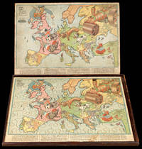
London,: G.W. Bacon & Co,, 1914.. 530 by 705mm. (20.75 by 27.75 inches).. Chromolithographed map, laid on wood, cut into a jigsaw, housed in original box, small piece missing upper right. An humorous serio-comic map of Europe in jigsaw form, showing a satirical depiction of the beginning of the First World War. The principal combatants are portrayed in canine form: a British bulldog, French poodle, German dachshund and an Austro-Hungarian mongrel. The Royal Navy is controlled by John Bull in the costume of a Jack Tar. To the left, Russia is portrayed as a steamroller driven by the Tsar, who has already trapped the tail of the Austrian mongrel, and threatens to crush all before him. The mongrel is also being stung by a Serbian hornet and is leashed to the German dachshund, who is having his nose bitten by the British bulldog. Below the fighting dogs lies Italy as a soldier with gun in hand, deciding which side to join. To the right, Greece stares menacingly with dagger drawn at the Ottoman Empire,…
Read More Item Price
£2,500.00
£15.00
shipping to USA

Haupt-Ansicht von London: Panoramic view of Victorian London
- Used
- Condition
- Used
- Quantity Available
- 1
- Seller
-
London, United Kingdom
- Item Price
-
£50.00£15.00 shipping to USA
Show Details
Description:
Viertes Quartal-Prämienbild des Haus- und Familienbuchs,, 1861.. 305 by 445mm. (12 by 17.5 inches).. A panoramic view of London, showing the rapid industrialisation of the city: smoke is visible billowing from chimneys on either side of St Paul's Cathedral.
Item Price
£50.00
£15.00
shipping to USA
![Her Maj[es]ties Royal Palace & Park of St. James's.](https://d3525k1ryd2155.cloudfront.net/h/248/506/1391506248.0.m.jpg)
Her Maj[es]ties Royal Palace & Park of St. James's.: St James's Park To Her most Serene and most Sacred Majesty Anne by ye Grace of God Queen of Great Britain France and Ireland &c.
by [KIP, Johannes after KNYFF, Leonard]
- Used
- Condition
- Used
- Quantity Available
- 1
- Seller
-
London, United Kingdom
- Item Price
-
£2,000.00£15.00 shipping to USA
Show Details
Description:
[London,, c.1707].. Image: 518 by 893mm (20.5 by 35.25 inches). Sheet: 640 by 1021mm (25.25 by 40.25 inches).. Engraving on two sheets joined, numbered in manuscript lower right. A view of St James's Park from 'Britannia Illustrata', one of the most famous topographical series of the eighteenth century. 'Britannia Illustrata' was conceived by David Mortier as a survey of the most important buildings in the country, drawn by Leonard Knyff and engraved by Johannes Kip. It was first published in 1707, then reissued and expanded with a French title in 1708-1713. The lack of French title indicates the date of the present example. The view is taken from south of St James's Park looking north. To the far left is Buckingham House (later Buckingham Palace); other buildings depicted include St James's Palace, Marlborough House, Banqueting House, and Whitehall. There is a numbered key to the buildings at the lower edge of the print. The map's dedication to Anne is worth noting because it refers to her as the…
Read More Item Price
£2,000.00
£15.00
shipping to USA

Her Majesty Proceeding in State to Westminster Abbey.: The Coronation of Queen Victoria Crowned June 28th 1838.
by GRAF, J.
- Used
- Condition
- Used
- Quantity Available
- 1
- Seller
-
London, United Kingdom
- Item Price
-
£1,500.00£15.00 shipping to USA
Show Details
Description:
London,: Ackermann & C., 96 Strand,, 1838.. Image: 340 by 517mm (13.5 by 20.25 inches). Sheet: 450 by 590mm (17.75 by 23.25 inches).. Lithograph, with hand-colour. View of Queen Victoria's coronation procession. The large and imposing structure of Westminster Abbey can be seen in the background. To the foreground Victoria is shown peering out of the Golden State Coach, which has been used at the coronation of every British monarch since George IV. Her route is thronged by soldiers and the cheering public. To the far right of the image is a large five-tiered grandstand. J. Graf (fl.1824-1852) was a printer and lithographer, working in London. He often describes himself as 'Printer to Her Majesty' or 'Printer to the Queen' on some lithographs. He also worked in partnership with Soret under the name of 'Graf & Soret'. Rudolph Ackermann (1764-1834) German born publisher and lithographer, was one of the most prolific and successful publishers of late Georgian London. He is known to have had several…
Read More Item Price
£1,500.00
£15.00
shipping to USA

Herefordshire described: Rare Roger Rea edition of Speed's map of Herefordshire With the true plot of the Citie Hereford, as alsoe the Armes of thos Nobles that have bene intituled with that Dignitye.
by SPEED, John
- Used
- Condition
- Used
- Quantity Available
- 1
- Seller
-
London, United Kingdom
- Item Price
-
£1,000.00£15.00 shipping to USA
Show Details
Description:
[London],: to be solde by Roger Rea the Elder and younger at the Golden Crosse in Cornhill against the Exchange,, 1665.. 410 by 550mm. (16.25 by 21.75 inches).. Double-page engraved map, fine contemporary outline hand colour, upper left and right margins skilfully repaired, margins reinforced with japan paper. The map bears the imprint of Roger Rea the Elder and Younger. The Reas had purchased the rights to Speed's work from William Garrett in 1659, who had previously purchased them from the widow of William Humble in the same year. Skelton suggests that the father and son intended a new edition of the atlas for the Restoration of 1660. However, the atlas would appear not to have been published until 1665. This is borne out by an advertisement in the Term Catalogue by the subsequent owners of the plates, Thomas Bassett and Richard Chiswell, in 1675: "Mr John Speed's... Geography of the Kingdoms of England, Scotland, and Ireland... together with his Prospect... all in one entire Volume, hath been,…
Read More Item Price
£1,000.00
£15.00
shipping to USA

Het Scheep-en Koop-ryk Zardam Aen de Oost: View of Zaandam from the IJ en West-zyde van den Stroom de Zaen in Noort Kennemer Landt, uit het y, aen te zien. Zardam riche en vaisseaux & mar chandise's vue du cote d'orient & de l'occident : du cote de la rivierre y: vers le kennemer landt orriental.
by DE LETH, Hendrik
- Used
- Condition
- Used
- Quantity Available
- 1
- Seller
-
London, United Kingdom
- Item Price
-
£3,126.00£15.00 shipping to USA
Show Details
Description:
Amsterdam,: Andries & Hendrik de Leth,, [c1730].. 560 by 905mm (22 by 35.75 inches).. Engraving with etching, on two sheets joined. The port of Zaandam situated just north of Amsterdam was famous, in the eighteenth century, for its saw mills and ship building. So renowned for nautical architecture was Zaandam that Tsar Peter the Great, in 1697, spent sometime in the town, during his Grand Embassy. The house where the Tsar lodged, survives to this day. Andries de Leth (1662-1731) and Hendrik de Leth (1692-1759) were engravers, publishers, and mapmakers working in Amsterdam during the first half of the eighteenth century.
Item Price
£3,126.00
£15.00
shipping to USA

His Majesty King George IV Travelling: Hyde Park View Hyde Park
by DUBOURG, M. after POLLARD, James.
- Used
- Condition
- Used
- Quantity Available
- 1
- Seller
-
London, United Kingdom
- Item Price
-
£400.00£15.00 shipping to USA
Show Details
Description:
London,: Published & Sold by Edwd Orme, Publisher to the King, Bond Street, Corner of Brook Street,, 1821.. Image: 310 by 450mm (12.25 by 17.75 inches). Sheet: 508 by 648mm (20 by 25.5 inches).. Engraving and etching with aquatint and original hand colour. George IV is shown travelling through Hyde Park in a carriage, the year after he became king. The riders and walkers in the park are lifting their hats in greeting and respect. George had spent a long time waiting for the throne. He had been acting as Prince Regent since 1810, after his father George III was stricken by mental illness. The Prince Regent resented his father for not giving him enough money, sending his brothers away for their education, and for making him marry his cousin, Caroline of Brunswick, whom he separated from as soon as they had a child together. He retaliated during his regency by taking several mistresses, the most famous amongst them Maria Fitzherbert, and spending lavishly on grandiose projects like the Brighton…
Read More Item Price
£400.00
£15.00
shipping to USA
More Photos
Histoire des Pays Bas.: Caught short? Never settle for bog-standard again!
by [Lavatory Humour].
- Used
- Condition
- Used
- Quantity Available
- 1
- Seller
-
London, United Kingdom
- Item Price
-
£7,500.00£15.00 shipping to USA
Show Details
Description:
France,, [c1750].. Folio (457 by 330mm). Portable oak close stool, folding into eighteenth century kaki paneled calf, gilt, brass clasps and catches. No. 1: The travelling bibliophile will never be inconvenienced again, with this portable potty. Discreetly concealed within the bowels of a corpulent tome, the covers ease open to reveal a comfortable commode beneath which a porcelain chamber pot may be placed. No. 2: Also suitable for the relief of the armchair traveler, flushed with success, who wishes to never leave the comfort of their library. Going on the go, into a receptacle designed for purpose, was invented by the Ancient Greeks, and the earliest 'ourane' is dated to the sixth century BC. Concealing the chamber pot, within a commode or closet, however, is a relatively recent nicety; both fashionable and practical until the invention of the water closet by Alexander Cummings in 1775 - based on a design created by Elizabethan Sir John Harrington. Samuel Prosser applied for and received the…
Read More Item Price
£7,500.00
£15.00
shipping to USA

A History of the World in Twelve Maps: A History of the World in Twelve Maps
by BROTTON, Jerry
- Used
- Paperback
- Condition
- Used
- Binding
- Paperback
- Quantity Available
- 1
- Seller
-
London, United Kingdom
- Item Price
-
£10.99£15.00 shipping to USA
Show Details
Description:
London,: Penguin,, 2 May 2013.. 198 by 129mm. (7.75 by 5 inches).. Paperback, 544 pages. In this masterful study, historian and cartography expert Jerry Brotton explores a dozen of history's most influential maps, from stone tablet to vibrant computer screen. Starting with Ptolemy, "father of modern geography," and ending with satellite cartography, A History of the World in 12 Maps brings maps from classical Greece, Renaissance Europe, and the Islamic and Buddhist worlds to life and reveals their influence on how weliterallylook at our present world. As Brotton shows, the long road to our present geographical reality was rife with controversy, manipulation, and special interests trumping science. Through the centuries maps have been wielded to promote any number of imperial, religious, and economic agendas, and have represented the idiosyncratic and uneasy fusion of science and subjectivity. Brotton also conjures the worlds that produced these notable works of cartography and tells the stories…
Read More Item Price
£10.99
£15.00
shipping to USA

A History of the World in Twelve Maps: A History of the World in Twelve Maps
by BROTTON, Jerry
- Used
- Hardcover
- Condition
- Used
- Binding
- Hardcover
- Quantity Available
- 1
- Seller
-
London, United Kingdom
- Item Price
-
£30.00£15.00 shipping to USA
Show Details
Description:
London,: Allen Lane,, 6 September 2012.. 240 by 162mm. (9.5 by 6.5 inches).. Hardcover, 544 pages. In this masterful study, historian and cartography expert Jerry Brotton explores a dozen of history's most influential maps, from stone tablet to vibrant computer screen. Starting with Ptolemy, "father of modern geography," and ending with satellite cartography, A History of the World in 12 Maps brings maps from classical Greece, Renaissance Europe, and the Islamic and Buddhist worlds to life and reveals their influence on how weliterallylook at our present world. As Brotton shows, the long road to our present geographical reality was rife with controversy, manipulation, and special interests trumping science. Through the centuries maps have been wielded to promote any number of imperial, religious, and economic agendas, and have represented the idiosyncratic and uneasy fusion of science and subjectivity. Brotton also conjures the worlds that produced these notable works of cartography and tells…
Read More Item Price
£30.00
£15.00
shipping to USA

Hong Kong surveyed by Capt. Sir Edward Belcher.: First British Survey of Hong Kong in H.M.S. Sulphur 1841.
by BELCHER, Captain
- Used
- Condition
- Used
- Quantity Available
- 1
- Seller
-
London, United Kingdom
- Item Price
-
£20,000.00£15.00 shipping to USA
Show Details
Description:
London,: Hydrographic Office of the Admiralty,, May 1st, 1843 - Corrected to 1846.. 700 by 1020mm (27.5 by 40.25 inches).. Engraved chart The British Hydrographic Office was founded in 1795 by George III, who appointed Alexander Dalrymple as the first Hydrographer to the Admiralty. The first charts were produced in 1800. Unlike the U. S. Coast Survey, the Hydrographic Office was given permission to sell charts to the public and they produced a great number of sea charts covering every corner of the globe. Most of the Admiralty charts produced by the Hydrographic Office delineated coastline as well as high and low water marks and record depth of water as established by soundings. In addition, these charts included information on shoals, reefs, and other navigational hazards that plagued mariners across the world. Thanks to the innovations of Sir Francis Beaufort, who developed the Beaufort Scale of wind strength, the British Hydrographic Office became one of the leading producers of sea charts. Sir…
Read More Item Price
£20,000.00
£15.00
shipping to USA
Hong Kong and the New Territories. North Sheet.: The liberation of Hong Kong from Japanese Occupation
by BRITISH WAR OFFICE
- Used
- Condition
- Used
- Quantity Available
- 1
- Seller
-
London, United Kingdom
- Item Price
-
£7,000.00£15.00 shipping to USA
Show Details
Description:
[London], : War Office, , Aug[ust] 1945.. 780 by 1050mm. (30.75 by 41.25 inches).. Chromolithograph map with manuscript annotations in pencil and pen, with three insets and diagrams to right margin, minor browning, a few nicks and tears to margins. A unique map of Hong Kong and the New Territories, with contemporary manuscript annotations showing the liberation of Hong Kong from Japanese occupation. This map, which shows Hong Kong, Kowloon and the New Territories, was first published by the British War Office in 1936. The present example, a second edition, was published shortly after the end of the Second World War, when Britain reoccupied the islands following four years of Japanese occupation. Thick red lines across the map indicate the "all weather roads" that could be relied upon for travel and communications across the region. Extending from Lantau Island to the west to Mirs Bay in the east, from the Chinese city of Shenzhen in the north to the southern Soko Islands, it is generally considered…
Read More Item Price
£7,000.00
£15.00
shipping to USA

Hong Kong and the New Territories. North Sheet.: Hong Kong after Japanese occupation
by BRITISH WAR OFFICE
- Used
- Condition
- Used
- Quantity Available
- 1
- Seller
-
London, United Kingdom
- Item Price
-
£750.00£15.00 shipping to USA
Show Details
Description:
[?London], : War Office,, Aug[ust] 1945.. 780 by 1050mm. (30.75 by 41.25 inches).. Chromolithograph map, with three insets and diagrams to right margin, browning and tears to left margin. An important map of Hong Kong and the New Territories published by the British War Office in 1945. Following the end of the First Opium War in 1942, China ceded Hong Kong to Great Britain and the island became a Crown Colony of the extensive Empire. Throughout the following decades, Britain guarded the territory closely, becoming increasingly concerned about the security of its port, which was essential for trade. The government therefore decided to create a buffer zone around the island to defend it against incursions from the nearby Chinese areas. The first part of this buffer was formed by Kowloon in 1860, when Britain took control of the peninsula in the aftermath of the Second Opium War. Further reinforcement came in 1898, when Britain gained a 99 year lease for 200 small islands surrounding Hong Kong, which…
Read More Item Price
£750.00
£15.00
shipping to USA

The Horse Guards: Horse Guards
by ROOKER, Edward after ROOKER, Michael Angelo
- Used
- Condition
- Used
- Quantity Available
- 1
- Seller
-
London, United Kingdom
- Item Price
-
£600.00£15.00 shipping to USA
Show Details
Description:
London,: Publish'd as the Act directs by Edwd. Rooker, in Queens Court, Queen Street, Lincoln Inn Fields,, 1768.. 430 by 575mm. (17 by 22.75 inches).. Engraved print. A view of Horse Guards seen from Whitehall through an arch. From the series 'Six Views of London', by Edward Rooker. Rooker made the series of prints after drawings by the artists and brothers Paul and Thomas Sandby, and his son Michael 'Angelo' Rooker, whose teasing nickname was given to him by the Sandby brothers, and eventually stuck. Adams 1983 58.3; BL 1880,1113.2764; NT 792134.
Item Price
£600.00
£15.00
shipping to USA
![Huangchao yitong yudi quantu [Complete Map of the Unified Qing Empire].](https://d3525k1ryd2155.cloudfront.net/h/276/506/1391506276.0.m.jpg)
Huangchao yitong yudi quantu [Complete Map of the Unified Qing Empire].: Longitude and Latitude on a map of the Qing Empire
by Dong Fangli (Youcheng) ( ) (1791-1823), Li Zhaoluo (1769-1841)
- Used
- first
- Condition
- Used
- Quantity Available
- 1
- Seller
-
London, United Kingdom
- Item Price
-
£65,000.00£15.00 shipping to USA
Show Details
Description:
Changzhou, China,, 1865 [1832].. (if joined) 1780 by 2340mm. (70 by 92.25 inches). (each sheet) 203 by 277mm. (8 by 11 inches).. Wood-block printed map of the unified Qing Empire, comprising sixty-four sheets. Two titles in seal script to upper centre and upper right in two lines. An ambitious map comprising sixty-four sheets, divided into eight rows, each covering a latitude of 5°30' made under the reign of Emperor Daoguang (1872- 1850, r. 1820-1850). Engraved and printed by two-colour process, the map utilizes a dual-grid system; a grid of squares in black, and the system of longitude and latitude in red. The prime meridian runs through Beijing. The map was the most advanced and complete map of the Qing Empire in the early nineteenth century. The original map of Huangchao yitong yudi quantu first printed in 1832, was comprised of forty-one sheets, and drawn by Dong Fangli, on the basis of Kangxi huangyu quanlan tu (Complete Map of the Empire of the Kangxi Era, 1719), and Qianlong neifu…
Read More Item Price
£65,000.00
£15.00
shipping to USA

Hudson Market: Done by Order of the Corporation by John W. Comb Esq., City Surveyor, New York, 22nd December, 1784. Examined & Approved by the Common Council,... & ordered to be filed in the Clerk’s Office. Rob.t Benson Esq.
by McCOMB, John; and Robert BENSON Esq.,
- Used
- Condition
- Used
- Quantity Available
- 1
- Seller
-
London, United Kingdom
- Item Price
-
£20,000.00£15.00 shipping to USA
Show Details
Description:
Original pen and ink and colour wash on vellum, contemporarymanuscript title on verso "Hudson Market", later inscription "Vesey Street Market", "3-S", old vertical folds. 285 by 315mm (11.25 by 12.5 inches).Original manuscript plat map of the area in lower Manhattan that would later become the site of the World Trade Center, and ultimately the 9/11 Memorial
The new Hudson Market, historically known as the Bear Market, is depicted in this map oriented with southeast to the top, bordered by Greenwich Street to the left, Vesey Street and "Corporation Dock" at the bottom, Partition Street along the top, and a "Dock" and a "Slip" extending into the Hudson River on the right. The survey is amongst the earliest work of the young City Surveyor, John McComb, and was prepared to record the auction of nine new lots, here coloured green, on land recently reclaimed from the Hudson River.
What is now site of the 9/11 Memorial, first appeared in a survey of 1625, as one small corner of thirty-three acres set aside… Read More
Item Price
£20,000.00
£15.00
shipping to USA

A Humorous Diplomatic Atlas of Europe and Asia.: Serio Comic map of Europe
by OHARA, Kisahuro
- Used
- Condition
- Used
- Quantity Available
- 1
- Seller
-
London, United Kingdom
- Item Price
-
£6,000.00£15.00 shipping to USA
Show Details
Description:
1904.. 420 by 570mm (16.5 by 22.5 inches).. Colour lithograph map. A wonderful example of the rare 1904 Kisabur Ohara satirical 'Octopus Map' of Europe. Composed at the outbreak of the Russo-Japanese War (1904 1905), Ohara here follows the conventions established by J.J. van Brederode ( Humoristische-Oorlogskaart, 1870) and Fred Rose (Serio-Comic War Map, 1877). These two maps established the convention, of satirizing Russian expansionism as a menacing Kraken-like 'Black Octopus.' Whereas Brederode and Rose confine their images to Russia, Ohara has here expanded the idea to encompass all of Eurasia. Russia's eight grasping tentacles extend across Europe and Asia; on many countries they already have a firm grip. Finland, Poland, Crimea, and the Balkan nations are represented as skulls, while tentacles grasp Turkey around the foot and waist, Persia about the neck, and Tibet by the arm. The Trans-Siberian Railway and the South Manchuria Railway, represented by the rightmost tentacle, had by this…
Read More Item Price
£6,000.00
£15.00
shipping to USA

Hunting Map of the Country near Gibraltar: The hunting ground of the Calpe
by BOTTOMLEY, A.H.
- Used
- Hardcover
- Condition
- Used
- Binding
- Hardcover
- Quantity Available
- 1
- Seller
-
London, United Kingdom
- Item Price
-
£750.00£15.00 shipping to USA
Show Details
Description:
1957.. 634 by 546mm. (25 by 21.5 inches).. Printed map on waxed cloth, with original hand colour and manuscript annotation. An interesting hunting map of Gibraltar. At the lower left corner information is given on the meeting places of the Calpe Hunt. The Calpe was founded in 1812, after a chaplain imported two English foxhounds, supposedly to keep down the fox population. It grew into a successful hunt, and eventually gained the patronage of both Edward VII of Britain and Alfonso XIII of Spain. The map is a wonderful depiction of English social customs in Gibraltar. In the list of places the hunt meets, the third is 'Rotten Row', taking its name from the area in Hyde Park in London. This is a copy of a map of the same title printed in 1907, possibly made on waxed cloth so that the owner could take it to the hunt. An example of the 1907 map is held at the Centro Geográfico del Ejército in Madrid. Centro Geográfico del Ejército Ar.G-T.10-C.1-1048
Item Price
£750.00
£15.00
shipping to USA

Hydrographical Chart of the World: Pivot to the Pacific According to Wrights, or Mercators Projection Delineated by A. Arrowsmith 1811 ... Additions to 1814.
by ARROWSMITH, Aaron
- Used
- Condition
- Used
- Quantity Available
- 1
- Seller
-
London, United Kingdom
- Item Price
-
£35,000.00£15.00 shipping to USA
Show Details
Description:
London,: Aaron Arrowsmith,, 1814.. 1525 by 2590mm (60 by 102 inches).. Engraved map, fine original hand-colour in outline, dissected and mounted on linen, in eight sections. The last and largest of Aaron Arrowsmith's world maps, representing the culmination of a career. It is one of the earliest world maps to reflect the explorations of, and map made by, Captain Meriwether Lewis and William Clark during their 1804-06 exploration of North America. Aaron Arrowsmith (1750-1823) was a well-respected mapmaker and publisher who had made his reputation through his commitment to representing the most up-to-date information on all his maps, especially the rapidly changing events in North America. His works "to this day retain a well merited reputation for their accuracy, distinctness and fine engraving" (Wheat). The map advertises in the title that it uses "Wrights, or Mercators Projection". Arrowsmith has used this projection to construct this map, unusually centred on the Pacific Ocean. The title cartouche…
Read More Item Price
£35,000.00
£15.00
shipping to USA

Didn’t find what you’re looking for?
Try adding this search to your want list. Millions of books are added to our site everyday and when we find one that matches your search, we’ll send you an email. Best of all, it’s free.
Add to Want List

Are you a frequent reader or book collector?
Join the Bibliophile's Club and save 10% on every purchase, every day — up to $20 savings per order!

Social Responsibility
Did you know that since 2004, Biblio has used its profits to build 16 public libraries in rural villages of South America?
