Description:
London,: E. Wallis, Skinner St,, [c1842].. 680 by 500mm. (26.75 by 19.75 inches).. Hand coloured engraved map with aquatint, dissected and mounted on linen. Wallis's rare and entertaining map of the United States. This scarce and beautiful instructional game was to be played as a lotto, each player moving around the finely detailed map which is crowded with vignettes of American life and wildlife. 'It is probably the earliest game to utilise a map of the United States' (Whitehouse). The game aimed to teach an English audience about the United States, some of the descriptions in the rule book - present in the British Library copy, however not sold with the current example - must have astounded the young players, with the entry on Arkansas restricted to the "lynch law", and a number of references to slavery including, "The slave-holders of the southern states are extensively supplied from the markets of Virginia, where negroes are reared for the purpose of sale and traffic... the last taint of negro…
Read More Search Results: Titles starting with G from Daniel Crouch Rare Books Ltd
You searched for:
- Bookseller inventory: Daniel Crouch Rare Books Ltd (titles starting with G)
- Bookseller: Daniel Crouch Rare Books Ltd
Results 1 - 20 of 40

Game of the Star-Spangled Banner.: One of the earliest game maps featuring the United States
by WALLIS, Edward
- Used
- Condition
- Used
- Quantity Available
- 1
- Seller
-
London, United Kingdom
- Item Price
-
£7,000.00£15.00 shipping to USA
Show Details
Item Price
£7,000.00
£15.00
shipping to USA

Geb. d.30 June 1748 auf dem Observatorium zu Paris.
by WESTERMAYER, C[onrad] [after] CLESS, [Jean Henri]
- Used
- Condition
- Used
- Quantity Available
- 1
- Seller
-
London, United Kingdom
- Item Price
-
£300.00£15.00 shipping to USA
Show Details
Description:
[Weimar,: Friedrich Justin Bertuch,, c1808].. 140 by 90mm. (5.5 by 3.5 inches).. Prints,""Jean. Domin. Cassini. Jean Dominique Cassini II Stipple-engraved portrait. Jean-Dominique Cassini (1748 1845) was the last in the line of prominent French astronomers originating with his great-grandfather, also named Jean-Dominique Cassini. Born at the Paris Observatory, Cassini was raised to be an astronomer. In 1770, Cassini published an account of a voyage to America that he had undertaken 1768 in order to test Pierre Le Roy's watches at sea. In 1783, he made a proposal to the Royal Society for a trigonometric survey connecting the observatories of Paris and Greenwich for the purpose of better determining the latitude and longitude of the latter. His proposal was accepted, and the results of the subsequent Anglo-French Survey were published in 1791. As well as fulfilling his inherited role as director of the observatory, Cassini also completed his father's map of France, which served as the basis for…
Read More Item Price
£300.00
£15.00
shipping to USA
Geb. zu Hamburg d. 19 Jan 1747.
by [ANONYMOUS]
- Used
- Condition
- Used
- Quantity Available
- 1
- Seller
-
London, United Kingdom
- Item Price
-
£300.00£15.00 shipping to USA
Show Details
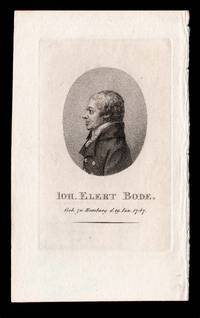
Description:
[Weimar,: Friedrich Justin Bertuch,, 1807].. 140 by 90mm. (5.5 by 3.5 inches).. Prints,""Joh. Elert Bode. Johann Elert Bode Stipple-engraved portrait. Volume 23 of the 'Allgemeine Geographische Ephemeriden' published in 1807 contained a portrait of German astronomer Johann Elert Bode (1747 - 1826). As director of the Berlin Observatory, Bode named Uranus after it was determined to be a planet in 1783. His star atlas of 1801, which he named the 'Uranographia', was the largest to date and contained the positions of more than 17,000 stars. In fact, it was one of the last scientific astronomic atlases to depict the traditional figures for constellations. His portrait in the """"AGE"""" shows Bode wearing a formal coat and cravat. His profile positioning was probably intended to hide the obvious damage done in his youth to his right eye by a disease. Beneath the portrait, set in an oval, his name and date of death are given. Wellcome 338.
Item Price
£300.00
£15.00
shipping to USA

Gebohr.zu Nieder Kamalch d. 20ton Märtz 1663. Gestorb. Zu Nürnberg d.1re Julü 1724.
by WESTERMAYER, C[onrad] [after] KENCKEL, [Johann]
- Used
- Condition
- Used
- Quantity Available
- 1
- Seller
-
London, United Kingdom
- Item Price
-
£300.00£15.00 shipping to USA
Show Details
Description:
[Weimar,: Friedrich Justin Bertuch,, 1801].. 132 by 89mm. (5.25 by 3.5 inches).. Prints,""Ioh. Bapt. Homann. Johann Baptist Homann Stipple-engraved portrait. Another portrait of Johann Baptist Homann appeared in Volume 8 of the 'Allgemeine Geographische Ephemeriden' published in 1801. The engraving was executed in the magazine's signature style, with the portrait in an oval and the subject's name and significant dates given below, and like many others was made by Conrad Westermayer. It was based on a painting of Homann made by Johann Kenckel while the publisher was alive, and shows him wearing a formal coat and cravat, along with a large powdered wig.
Item Price
£300.00
£15.00
shipping to USA

A General Chart For the purpose of pricking off a Ship's Track from England, &c. Southward, and round the World.: Rare prick chart of the world Drawn by J.S. Hobbs, F.R.G.S. Hydrographer. 1861.
by HEATHER, William [and], J[ames] W[illiam] NORIE
- Used
- Condition
- Used
- Quantity Available
- 1
- Seller
-
London, United Kingdom
- Item Price
-
£4,000.00£15.00 shipping to USA
Show Details
Description:
London,: Published by Charles Wilson (late J.W. Norie & Wilson) No.157 Leadenhall Street,, 1877.. 820 by 1610mm (32.25 by 63.5 inches).. Engraved chart, on five sheets joined and backed on linen, edged in linen, a few water stains to far right. Rare chart of the world published for use aboard merchant and passenger shipping, in order to mark a ships track. With ships constantly sailing back and forth between Britain and Asia, it was essential to ensure smooth and efficient passages. To this end in the 1790s William Heather, hydrographer to the East India Company, began publishing blank charts for use by East India Company shipping, which they could use as a template to plot their tracks through the sea. The charts would continue to be published by Heather, and his successor's Norie and Wilson, through much of the nineteenth century. The present example identifies ports and harbours at which the ships might wish to stop off, as well as various shoals, reefs, and ice that could prove to be dangerous…
Read More Item Price
£4,000.00
£15.00
shipping to USA

A General Map of Scotland and Islands thereto belonging: Dorret's Landmark Wall Map of Scotland From new Surveys, the Shires properly Divided & Subdivided, the Forts lately Erected & Roads of Communication or Military Ways carried on by His Majesty's command, the Times or Military ways, the Danish Camps & Forts
by DORRET, J[ames]
- Used
- Condition
- Used
- Quantity Available
- 1
- Seller
-
London, United Kingdom
- Item Price
-
£6,000.00£15.00 shipping to USA
Show Details
Description:
London,, April the 1750.. 1780 by 1370mm. (70 by 54 inches).. Large engraved wall map on eight double-page sheets and 4 half sheets, joined, inset plan of the Shetland Islands upper right, list of "the Most Remarkable Places in Scotland" lower left, with fine contemporary hand-colour in full. James Dorret's map of Scotland "was a landmark map which was used directly or indirectly for nearly all Scottish maps for the next 40 years" (National Library of Scotland). Dorrett was an Englishman serving as a valet to the Duke of Argyll, who was given the task of mapping first Argyll and then all of Scotland with the Duke's financial backing. He carried out his own survey for this, his first monumental map of Scotland, supplementing it with information from William Roy's on-going Military Survey of Scotland, completed between 1747 and 1755, and with the latest estate and maritime surveys. His authorship of the Argyll estate survey has been established by the correspondence of John Ainslie, a cartographer…
Read More Item Price
£6,000.00
£15.00
shipping to USA

A General Chart of the Hoogly River: Kolkata and the Hoogly River and the Approaches to it from False Point to Calcutta Compiles from the Surveys of Captn. Lloyd and his Assistants. By John Walker, Geographer to the Honble. E. I. Company.
by LLOYD, Captain
- Used
- Condition
- Used
- Quantity Available
- 1
- Seller
-
London, United Kingdom
- Item Price
-
£1,000.00£15.00 shipping to USA
Show Details
Description:
London,: W.H. Allen & Co., 7 Leadenhall St London,, 1840 (additions to 1845).. 840 by 790mm (33 by 31 inches).. Engraved chart on two map sheets with one inset view, part of the right margin restored in facsimile, some discolouration to the margins and a few minor tears. This rare map of the Hooghly River shows the river weaving through West Bengal from Kolkata, shown as an inset map, down to False Point harbour in the Bay of Bengal. The large delta is displayed prominently, complete with soundings, sailing instructions and notes on the quality of the river-bed beneath. As a navigable distributary of the Ganges, the Hooghly was of great importance in trade and communications, and after the Seven Years' War (1756-63), the English East India Company emerged as the dominant power on the river. The British soon established themselves at Calcutta, furnishing the settlement with distinctive European features, such as the fort shown on the inset map and labelled "Fort William". Local towns situated on the…
Read More Item Price
£1,000.00
£15.00
shipping to USA

Geo-Hydrographic Survey of the Isle of Madeira: William Johnston's plan of Madeira with the Dezertas and Porto Santo Islands geometrically taken in the year 1788. By William Johnston Esq[ui]r[e]. This Chart drawn from actual Surveys taken with the Permission of His Excellency Don Diego Perreira Forjas
by JOHNSTON, William
- Used
- Condition
- Used
- Quantity Available
- 1
- Seller
-
London, United Kingdom
- Item Price
-
£2,800.00£15.00 shipping to USA
Show Details
Description:
London: Digested and Published by W. Faden, Geographer to the King,, Jan[uar]y 1st, 1791.. 1160 by 620mm (45.75 by 24.5 inches).. Two engraved charts, on two sheets joined, fine original hand-colour, inset plan of Funchal, first chart with view of Funchal and plan of the road of Funchal. The British had particularly strong links with Madeira. The island had been under Portuguese rule since its discovery in 1418 - Portugal being the country with which England had (and still has) its oldest diplomatic alliance - based on the Treaty of Windsor of 1386. This alliance was further strengthened when, in 1662, Charles II married Catherine of Braganza. As a result Englishmen were allowed to settle on the island. Many of the new arrivals would later become involved in the lucrative Madeira port trade. It is likely that William Johnston, the author of the present chart, was involved in the industry, as one William Johnston is recorded as a partner in Newton, Gordon, and Johnston from 1777-1791. The company -…
Read More Item Price
£2,800.00
£15.00
shipping to USA

More Photos
A Geographical Description of the Four Parts of the World.: The first folio world atlas printed in England
by BLOME, Richard
- Used
- Hardcover
- Condition
- Used
- Binding
- Hardcover
- Quantity Available
- 1
- Seller
-
London, United Kingdom
- Item Price
-
£40,000.00£15.00 shipping to USA
Show Details
Description:
London, : T[homas] N[ewcombe] for R. Blome,, 1670.. 5 parts in one volume, folio (374 by 234mm), titles printed in red and black, double-page engraved folding twin-hemisphere map of the world and 24 double-page maps (the maps of N. Afria and Mediterranean joined to form one), each with original hand-colour in outline, with cartouches hand-coloured in full and mounted on guards, Ex libris Fox Pointe Collection, binding full speckled calf, spine in seven compartments separated by raised bands, gilt. Richard Blome's atlas is the first folio world atlas that was uniformly assembled in England, including its engraving, printing, and publishing. It is the first folio world atlas to be published in England since 1627 when John Speed presented Prospect of the Most Famous Parts of the World, which had its plates engraved and printed in Amsterdam. Blome was one of the most prolific publishers in post-Restoration London active between 1677 and 1705. He published a number of successful volumes including…
Read More Item Price
£40,000.00
£15.00
shipping to USA

More Photos
Geographicae Enarrationis, Libri Octo.: Servetus - the expurgated edition - with contemporary hand-colour Ex Bilibaldi Pircheymheri tralatione, sed ad Graeca & Prisca exemplaria a Michaele Villanovan (d.i. Servertus) secondo recogniti, & locis innumeris denuo castigati.
by PTOLEMAEUS, Claudius; and Michael VILLANOVANUS, known as 'SERVETUS'
- Used
- Hardcover
- Condition
- Used
- Binding
- Hardcover
- Quantity Available
- 1
- Seller
-
London, United Kingdom
- Item Price
-
£200,000.00£15.00 shipping to USA
Show Details
Description:
Prostant Lugduni,: apud Hugonem a Porta,, 1541.. 405 by 285mm. (16 by 11.25 inches).. Folio. Large woodcut printer's device on title-page; double-page woodcut old map of the world, 26 old regional maps, 2 modern maps of the world, 20 new regional maps and one full-page, most with text enclosed in elaborate woodcut borders, probably by Hans Holbein and Urs Graf, text with 2 full-page woodcuts of a diagram and armillary sphere showing the projection of the winds by Albrecht Dürer (l4 verso), all with magnificent contemporary hand-colour in full, 4 large woodcut diagrams, woodcut initials, colophon n4 present, seventeenth-century limp vellum, recased. Collation: a-i(6), k-m(6), n(4), 50 maps, A-G(6), 2[-]; pp., [1]-149, [3], 50 maps, [76]. Beautifully coloured in a contemporary hand throughout, and very rare as such, this is the second edition of Ptolemy's 'Geographia' to be edited by Michael Villanovanus, better known as Servetus, (c1490-1570). It was printed by Gaspar Trechsel for Hugues de la Porte…
Read More Item Price
£200,000.00
£15.00
shipping to USA

More Photos
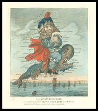
Geography Bewitched! Or a Droll caricature of Map of ENGLAND & WALES;: Geography Bewitched! [with] Geography Bewitched! Or a Droll caricature of Map of IRELAND This Portrait of LADY HIBERNIA BULL is humbly dedicated to her Husband the great Mr JOHN BULL; [with] Geography Bewitched! Or a Droll caricature of Map of SCOTLAND.
by DIGHTON, Robert
- Used
- Condition
- Used
- Quantity Available
- 1
- Seller
-
London, United Kingdom
- Item Price
-
£7,500.00£15.00 shipping to USA
Show Details
Description:
London,: Bowles & Carver,, [c1796].. 215 by 180mm. (8.5 by 7 inches).. Set of three engraved caricature maps, with fine original hand-colour. A fine set of Robert Dighton's "Geography Bewitched" series, depicting England, Wales, Scotland, and Ireland in a humorous light. England and Wales are depicted as John Bull with full tankard of beer in hand and riding a monstrous fish; Scotland is a merry gent, who sits on a wool sack and carrying a tartan sack over his shoulder; and Ireland as a merry woman - who is said to the wife of John Bull - in traditional dress playing the harp. The series was the work of Robert Dighton (c1752-1814) a well-known painter of portraits and caricatures, as well as decorative subjects, who is regarded as one of the most talented social caricaturists of the late eighteenth and early nineteenth centuries. The series like much of Dighton's caricatures were published by Carington Bowles (fl.1752-1793). Carington Bowles worked initially with his father, John Bowles, before…
Read More Item Price
£7,500.00
£15.00
shipping to USA

Geograph des Franz. Ministeriums der auswartigen Angelegenheiten.
by BARBIE DU BOCAGE, Jean-Denis] [WESTERMAYER, Conrad]
- Used
- Condition
- Used
- Quantity Available
- 1
- Seller
-
London, United Kingdom
- Item Price
-
£200.00£15.00 shipping to USA
Show Details
Description:
[Weimar: Friedrich Justin Bertuch,, 1803].. 140 by 90mm. (5.5 by 3.5 inches).. Prints,""Jean Denys Barbié du Bocage Jean-Denis Barbié du Bocage Stipple-engraved portrait. In 1798, German astronomer Franz Xaver von Zach partnered with influencial publisher Friedrich Justin Bertuch to launch the very first astronomical-geographical journal, the 'Allgemeine geographische Ephemeriden'. Depsite disputes between Zach, who had in mind a purely scientific journal, and Bertuch, who wanted to produce an educational magazine for the enthusiast, the AGE continued to appear under a variety of names until 1831. In 1803, the twelfth volume of 'Allgemeine Geographische Ephemeriden' featured a portrait of Jean-Denis Barbié du Bocage (1760-1825), the only student taken on by the important French geographer Jean-Baptiste Bourguignon d'Anville. With this promising training, Barbié du Bocage went on to enter government in a cartographical capacity, taking charge of the geographical department of the Bibliothèque…
Read More Item Price
£200.00
£15.00
shipping to USA
Geography Bewitched or a droll Caricature Map of England and Wales.: Dighton's caricature map of England and Wales
by DIGHTON, Robert
- Used
- Condition
- Used
- Quantity Available
- 1
- Seller
-
London, United Kingdom
- Item Price
-
£1,700.00£15.00 shipping to USA
Show Details
Description:
London,: Printed for Bowles & Carver, No. 69 St. Paul's Church Yard,, [c1795].. 210 by 180mm (8.25 by 7 inches).. Engraved caricature map with fine original hand-colour, tape marks to margins, tear to imprint skilfully repaired, with minor loss. This humorous map is part of the series of cartographic caricatures - including England and Wales, as here, Scotland, and Ireland - which Robert Deighton first produced in the late eighteenth century. England and Wales are depicted as John Bull with full tankard of beer in hand and riding a monstrous fish. The map like much of Dighton's caricatures would be published as a print by Carrington Bowles (fl.1752-1793). Carington Bowles worked initially with his father, John Bowles, before leaving to take over his uncle Thomas Bowles (II)'s business, circa 1762. Carington Bowles was one of the most active mapsellers and publishers of his day in London. His business was continued by his some Henry Carington Bowles who, in partnership with Samuel Carver, continued…
Read More Item Price
£1,700.00
£15.00
shipping to USA

A Geological Map of England and Wales: Rare reduction of Greenough's geological map of England and Wales reduced by permission from the map in 6 sheets published by the Geological Society.
by [GREENOUGH, George Bellas]
- Used
- Hardcover
- Condition
- Used
- Binding
- Hardcover
- Quantity Available
- 1
- Seller
-
London, United Kingdom
- Item Price
-
£5,000.00£15.00 shipping to USA
Show Details
Description:
London,: Published by J. Gardner, , July 21st, 1826.. 685 by 560mm (27 by 22 inches).. Engraved map, fine original hand-colour, dissected and mounted on linen, folding into original green cloth slipcase, with publisher's label. Greenough (1778-1855) was the first President of the Geological Society, and was later President of the Royal Geographical Society. The Geological Society was founded in 1807, but Smith never became a member, although his geological work that was the basis of the map was well underway by then. Greenough had actually been shown a copy of an early version of Smith's map by the surveyor John Farey in 1802, who later attacked Greenough in the press for his "unhandsome conduct" in the matter (Philosophical Magazine). There were probably two reasons for this: personally, Smith probably could not afford the membership fee; and professionally, he advocated a method of differentiating between strata using the fossils in each layer. This theory went against the prevailing scientific…
Read More Item Price
£5,000.00
£15.00
shipping to USA

Geological Map of Sussex by W. Smith Mineral Surveyor: Smith's rare geological survey of Sussex A New Map of Sussex Divided into Hundreds. Exhibiting Its Roads, Rivers, Parks Etc.
by SMITH, William
- Used
- first
- Condition
- Used
- Quantity Available
- 1
- Seller
-
London, United Kingdom
- Item Price
-
£10,000.00£15.00 shipping to USA
Show Details
Description:
London,: Published by J. Cary Engraver and Mapseller, No 181 the Strand,, January 1819.. 480 by 535mm. (19 by 21 inches).. Engraved broadsheet map with hand colour; small loss to the left margin, slightly affecting the text but not the image, some strengthening to the folds; manuscript text on the verso. First edition of William Smith's geological map of Sussex, one in a series of county maps produced by Smith, each separately issued, which were the first detailed geological maps of specific areas. Smith's individual maps are extremely rare on the market. Smith produced the first geological map of England and Wales in 1815, which contained "an amazing amount of correct detail" (D.S.B.) and was the basis for all the geological maps that followed. In 1819 he began the publication of a geological atlas of England and Wales. Published in parts over five years, it remained unfinished, containing twenty-one maps of various English counties. "All the county maps published contain much more…
Read More Item Price
£10,000.00
£15.00
shipping to USA

More Photos
Geology, Familiarly Illustrated by C. M. W.: Geology Personified
by W[EBBER] C[atherine]. M[ary].
- Used
- Condition
- Used
- Quantity Available
- 1
- Seller
-
London, United Kingdom
- Item Price
-
£3,500.00£15.00 shipping to USA
Show Details
Description:
London,: J. B. Goodinge, 21 Aldergate Street,, 1859.. Oblong octavo (130 by 150mm), continuous strip view, measuring 320 cm in length, containing thirty-one numbered and captioned hand-coloured lithographed scenes illustrating geology in a humorous vein, imprint label pasted to inside of back cover, original marbled covers with publisher's label pasted on. Humorous panorama illustrating geological features and stratification. Catherine Mary Webber (1831-1900), the wife of the Anglican clergyman Rev. William Fynes Webber, is known to have published three comical illustrated works such as this. The other two are 'The Experiences of an Amateur Artist' published in 1858 and 'Miss Scratchley, an Amateur in Art and Crinoline' in 1863. She also contributed to 'The English Woman's Journal' under the moniker 'A Clergyman's Wife.' The scenes herein are captioned: 1. "Gneiss on Granite". 2. "Cumbriam System". 3. "Cambriam System". 4. "Flags, and Transition Conglomerate". 5. "Silurian System". 6.…
Read More Item Price
£3,500.00
£15.00
shipping to USA

More Photos
Gerardi Mercatoris - Atlas sive Cosmographicae Meditationes de Fabrica mundi et fabricate figura: From the inventory of the Van Keulen family of cartographers De novo multis in locis emendates et Appendice auctus Studio Judicu Hondii.
by CLOPPENBURG, Johannes
- Used
- Hardcover
- first
- Condition
- Used
- Binding
- Hardcover
- Quantity Available
- 1
- Seller
-
London, United Kingdom
- Item Price
-
£60,000.00£15.00 shipping to USA
Show Details
Description:
Amsterdam,: Sumptibus Johannis Cloppenbergii,, Anno 1630.. 2 works in one volume. Oblong 4to., (250 by 275mm). 2 letterpress sectional title-pages, additional allegorical title-page with magnificent contemporary hand-colour in full, heightened with gold, a total of 180 engraved maps with contemporary hand-colour in outline, contemporary blind-paneled vellum over paste-board, title in manuscript on the spine. Collation: [-](4), A-I(4), K-T(4); V(4), X-Z(4), 2A-I(4), 2K-T(4), 2V(4), 2X-Z(4), 3A-I(4), 3K-T(4), 3V(4), 3X-Z(4), 4A-I(4), 4K(4)-Q(4); [4] pages, [1]-676; 'Appendix' a-f(4);[1-3], 4-[48] First edition of Cloppenburg's version of the miniature Mercator-Hondius atlas, with the 'Appendix', containing twenty-two maps. A finely coloured example, and rare as such, from the inventory of the Van Keulen family of cartographers. Including, as the last map in the 'Appendix', 'Nova Virginiae Tabula
': the first reduced version of "the first and most important derivative of John Smith's map of Virginia"…
Read More Item Price
£60,000.00
£15.00
shipping to USA

Germania et Anglia fouit, Martyr, quem extinctum, nunc tegit Helvetia. Discere quae si vera volent, re et nomine dicent, Hic fideus Christi (credite) Martur ?erat.
by H[ONDIUS, Hendrilk]
- Used
- first
- Condition
- Used
- Quantity Available
- 1
- Seller
-
London, United Kingdom
- Item Price
-
£500.00£15.00 shipping to USA
Show Details
Description:
[The Hague,: Hendrik Hondius,, c1599].. 171 by 120mm. (6.75 by 4.75 inches).. Prints,""Petrus Martyr, Tuscia te pepulit, Peter Martyr d'Anghiera Engraved portrait with Latin letterpress to verso. Despite being an Italian by birth, the historian, chaplain, teacher and diplomat Peter Martyr d'Anghiera (1457-1526) spent the majority of his life in Spain writing accounts of the many voyages undertaken to the New World. His most famous work was the 'Decades', published from 1511 to 1530, which charted early European exploration of the Central and South America. His 'De Orbe Novo' of 1530 described the first contacts of Europeans and Native Americans, and he is also credited with the publication of the very first printed map devoted solely to the Americas, which appeared in his 'Legatio Baylonica' of 1511. Martyr d'Anghiera's portrait, engraved by Hendrik Hondius I, was published in Jacob Verheiden's 'Praestantium aliquot theologorum ... effigies', a series of fifty-one portraits of notable scholars.…
Read More Item Price
£500.00
£15.00
shipping to USA
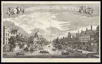
Gesicht Van De Cingelverby de Kerk Van die van de Ausburgische confessie naar Ian Roonpoorts toren tot Amsterdam.: View of the Singel canal in Amsterdam as viewed from the Prins Hendrikkade Fossa Cingens; Confessionis Augustanae Remplum transiens, Johannis que de porta rubra turrim respiciens Amstelaedamum.
by SCHENK, Jan [after] RADEMAKER, Abraham
- Used
- Condition
- Used
- Quantity Available
- 1
- Seller
-
London, United Kingdom
- Item Price
-
£3,530.00£15.00 shipping to USA
Show Details
Description:
Amsterdam,: Leonard Schenk,, [c1720].. 558 by 950mm (22 by 37.5 inches).. Engraving with etching, on two sheets joined. The most prominent feature of the of this view is The Ronde Lutherse Kerk or Koepelkerk is a former Lutheran church. The church was built in neo-classical style and has a characteristic copper dome. It was built in 1671 by Dutch Golden Age architect Adriaan Dortsman, who also built Museum Van Loon, a magnificent private residence at the Keizersgracht. When the Lutherans left the building in 1935, it became a concert hall. In 1993 the interior and characteristic green-colored copper dome were destroyed by fire. After a renovation period of 16 months, the church was fully restored. Further down the canal the imposing Roonports tower can be seen. Leonard Schenk (fl.1720-1746) an Jan Schenk (1698-1752) were brothers working as engravers and publisher's in Amsterdam. Abraham Rademaker (1677 21 January 1735) was an 18th-century painter and printmaker from the Northern Netherlands.…
Read More Item Price
£3,530.00
£15.00
shipping to USA
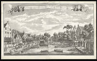
Gesigt van den Vermaakelyken Overtoom: View of the Overtoom Gelegen buyten de Leydsche Poort der Stad Amsterdam te sien naar de groote en kleyne overhaal. Vüe agreable de l'overtoom, hors de la porte de leide, pres de la ville d'astersdam
by SCHENK, Leon; [after] RADEMAKER, Abraham
- Used
- Condition
- Used
- Quantity Available
- 1
- Seller
-
London, United Kingdom
- Item Price
-
£3,750.00£15.00 shipping to USA
Show Details
Description:
Amsterdam,: Leon Schenk, Abraham Rademaker,, [c1720].. 560 by 960mm. (22 by 37.75 inches).. Engraving with etching, on two sheets joined. A view of the Overtoom in the eighteenth century. By the eighteenth century numerous country villas had been built along the Overtoom, one of the main canal's linking Amsterdam with river Schinkel, as well as pleasure gardens and numerous ale houses and shops. The Overtoom gained its name from the machine for moving a boat from one body of water to another where the level varied. Rather than with the aid of a lock, in other canal systems, the boat would be physically pulled across the land. The machine is depicted to the right of the print, consisting of two large wheels, it can be seen pulling a small boat onto the canal. Leonard Schenk (fl.1720-1746) engraver, mapmaker, and publisher in Amsterdam. Abraham Rademaker (1677 21 January 1735) was an 18th-century painter and printmaker from the Northern Netherlands. Rademaker was born in Lisse. According to the…
Read More Item Price
£3,750.00
£15.00
shipping to USA

Didn’t find what you’re looking for?
Try adding this search to your want list. Millions of books are added to our site everyday and when we find one that matches your search, we’ll send you an email. Best of all, it’s free.
Add to Want List

Are you a frequent reader or book collector?
Join the Bibliophile's Club and save 10% on every purchase, every day — up to $20 savings per order!

Social Responsibility
Did you know that since 2004, Biblio has used its profits to build 16 public libraries in rural villages of South America?
