Skip to content

Search Results: Titles starting with A from Original Antique Maps

You searched for:
  • Bookseller inventory: Original Antique Maps (titles starting with A)
  • Bookseller: Original Antique Maps
Results 1 - 5 of 5
Africa, 1830 [Manuscript]

Africa, 1830 [Manuscript]: Phebe Varney 1830. Dover, Duchess County [New York][Society of Friends]

  • Used
Condition
Used
Quantity Available
1
Seller
FRAMINGHAM, Massachusetts, United States
Seller rating:
This seller has earned a 5 of 5 Stars rating from Biblio customers.
Item Price
£2,104.18
£8.90 shipping to USA

Show Details

Description:
Details:Large manuscript map, signed, hand colored, ink and pigment on paper, backed with original linendated 1830, Dover, Duchess County [New York]dimensions: 18 ¾" x 23 1/8" within neat lines, 19 ½" x 23 ½" overallcondition: as found, generally good, 6" vertical tear, some edge wear, complete Description:This hand drawn map is signed "Phebe Varney, 1830. Dover Duchess County" on the front. The title of the map is "Africa". The map is hand drawn on thick paper with colored inks and possibly a fine brush. The thickness and opacity of the paper would not have permitted easy tracing and therefore it is most likely the author of the map drew it freehand, perhaps using a grid system (or longitude and latitude lines) to scale up or down a published map or set of maps of Africa. The map appears to be unique.
Phebe Varney and her family belonged to the Society of Friends in New York. She was born June 16, 1810 in Nine Partners, Duchess County, New York to Jedediah and Mary (Hoag) Varney according to… Read More
Item Price
£2,104.18
£8.90 shipping to USA
Aldus Chapin Higgins Photo Album, 1923 A Ten Weeks Vacation Trip to Europe February 23rd to May...
More Photos

Aldus Chapin Higgins Photo Album, 1923 A Ten Weeks Vacation Trip to Europe February 23rd to May 12th 1923: [Madeira, Gibraltar, Algiers, France, Sicily, Italy, Switzerland, New York]

by Aldus Higgins

  • Used
Condition
Used
Edition
Hand made book
Quantity Available
1
Seller
FRAMINGHAM, Massachusetts, United States
Seller rating:
This seller has earned a 5 of 5 Stars rating from Biblio customers.
Item Price
£5,260.45
£8.90 shipping to USA

Show Details

Description:
Photo Archive and Hand Made Book Details:Large format, elaborate hand-made book, unpaginated [95 pages], colored ink manuscript calligraphy on cover, bound in leather parchment over stiff boards, 306 large and medium format professional black and white photographs mounted on laid paper with deckled edges, each photo titled in manuscript, 3-page typed itinerary bound in at end of book, one small landscape oil painting "Taormina" bound in, 2-page color printed map laid in with itinerary hand drawn on map, separate set of 7 small format B&W photographs of the architecture of the Higgins home, newly completed, Worcester, Massachusetts, and one engraved calling card of Mr. and Mrs. Aldus Chapin Higgins 1 John Wing Road [Worcester, Massachusetts].
dimensions: 15 1/8" x 11 1/4" x 3"condition: book: as found, 100-year old parchment binding in good condition, parchment covers have some wear, condition: contents: as found, very good to excellent, heavy laid paper pages, a small Higgins oil painting, manuscript… Read More
Item Price
£5,260.45
£8.90 shipping to USA
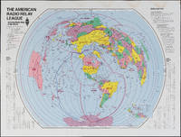
The Amateur Radio Relay League

The Amateur Radio Relay League: Amateur Radio Map of the World

by American Radio Relay League

  • Used
Condition
Used
Quantity Available
1
Seller
FRAMINGHAM, Massachusetts, United States
Seller rating:
This seller has earned a 5 of 5 Stars rating from Biblio customers.
Item Price
£263.02
£8.90 shipping to USA

Show Details

Description:
Color print on glossy paperDimensions: 31" x 40 3/4"Condition: as found, water stain along top margin, bright colors throughoutThis American Radio Relay League divides the world into radio relay league zones rather than political or geographic boundaries. The map could be thought of as a ham radio listeners "bird's ear" view of the world. Each zone is identified by the call letters for that zone, immediately recognizable to the experienced ham radio operator and part of a language unique to this kind of radio communication.
Item Price
£263.02
£8.90 shipping to USA
Atlas Historique De L'Urbanization De La France (1811-1975)
More Photos

Atlas Historique De L'Urbanization De La France (1811-1975): Editions Du Centre Nationale de la Recherche Scientefique

by Georges Dupeux

  • Used
  • Hardcover
  • first
Condition
Used
Binding
Hardcover
Quantity Available
1
Seller
FRAMINGHAM, Massachusetts, United States
Seller rating:
This seller has earned a 5 of 5 Stars rating from Biblio customers.
Item Price
£283.26
£8.90 shipping to USA

Show Details

Description:
Details:
dimensions: 17 3/4 x 23 5/8 x 1 inchesformat: text, maps and clear overlays bound in hard covers clamped together with metal pinscondition: very goodlanguage: FrenchDescription: Georges Dupeux, Professor at the University of Bordeaux, presents his mapping thesis that a historical review of France's population statistics expressed as the pattern of village, town and city growth will yield a missing portrait of the country. This atlas is mapping of data. This book provides the population statistics for France by town based on the census figures for 1809-1812. Using circles of different sizes to represent population size, Dupeux creates 19 maps for this atlas. Paris is dominant relative to all of the other settled areas in France with more than 5,000 inhabitants. Each map is bound with a clear plastic overly that also is printed in red with clusters of towns of from 3,000 to 4,999 inhabitants. Thus the Atlas demonstrates where and by what relative increases in population France has… Read More
Item Price
£283.26
£8.90 shipping to USA
Atlas of Ceskoslovenskych Dejin (1965)
More Photos

Atlas of Ceskoslovenskych Dejin (1965)

  • Used
  • Hardcover
Condition
Used
Binding
Hardcover
Quantity Available
1
Seller
FRAMINGHAM, Massachusetts, United States
Seller rating:
This seller has earned a 5 of 5 Stars rating from Biblio customers.
Item Price
£263.02
£8.90 shipping to USA

Show Details

Description:
Details:in Czeck, Preface, Credits, Table of Contents pp.11-3945 double page maps
dimensions: 20 x 17 1/4 x 1 1/4 inchesDescription: The color printed maps in this historical atlas of the Czech people uses many different kinds of mapping methods. Geographic maps are complemented by political boundary maps. Physical resources, topography and population are also mapped. Some of the maps are also illustrated with national symbols and emblems of different eras. The scale of the book is also a feature. The maps are large enough to convey an almost three dimensional quality to the subject matter.
Item Price
£263.02
£8.90 shipping to USA
Add to Want List

Didn’t find what you’re looking for?

Try adding this search to your want list. Millions of books are added to our site everyday and when we find one that matches your search, we’ll send you an email. Best of all, it’s free.

Add to Want List
Book lovers can save on books by joining our Bibliophiles club

Are you a frequent reader or book collector?

Join the Bibliophile's Club and save 10% on every purchase, every day — up to $20 savings per order!

Biblio is a socially responsible company

Social Responsibility

Did you know that since 2004, Biblio has used its profits to build 16 public libraries in rural villages of South America?