Description:
Leiden,: Franciscus Raphelengius for Luca Johannes Aurigarius, , 1586.. The rutter for which all waggoners are named 2 parts in one volume. Folio (415 by 292mm), engraved allegorical title-page to the first part, title-page with woodcut border to the second part, "Ad lectorem", without dedication (as often), 45 double-page engraved charts by Joannes and Baptista van Doetichum all with fine contemporary hand-colour in full, 3 full-page engraved text illustrations, expert repairs to upper corners of the majority of the charts, including map of Europe chart, a few with loss skilfully repaired in facsimile, contemporary vellum gilt, repairs to upper corners. A fine example of the first Latin edition of the earliest printed sea atlas: complete, with fine contemporary hand-colour in full. First published in Dutch in 1583-1584 as Spieghel der Zeevaerdt, the over-sized map of Europe is in the first state, showing a circular Iceland, all other maps in Koeman state b. "Waghenaer's work was a milestone in the…
Read More Search Results: Authors starting with W from Daniel Crouch Rare Books Ltd
You searched for:
- Bookseller inventory: Daniel Crouch Rare Books Ltd (authors starting with W)
- Bookseller: Daniel Crouch Rare Books Ltd
Results 1 - 20 of 76
![Speculum nauticum super navigatione maris occidentalis pars prima [-pars altera]](https://d3525k1ryd2155.cloudfront.net/h/262/716/1480716262.0.m.jpg)
More Photos
Speculum nauticum super navigatione maris occidentalis pars prima [-pars altera]
by WAGHENAER, Lucas Janszoon
- Used
- Hardcover
- Condition
- Used
- Binding
- Hardcover
- Quantity Available
- 1
- Seller
-
London, United Kingdom
- Item Price
-
£234,000.00£15.00 shipping to USA
Show Details
Item Price
£234,000.00
£15.00
shipping to USA

Tabula Moderna Norbegie et Gottie.: Waldeseemuller's map of Scandinavia
by WALDESEEMULLER
- Used
- Condition
- Used
- Quantity Available
- 1
- Seller
-
London, United Kingdom
- Item Price
-
£8,000.00£15.00 shipping to USA
Show Details
Description:
[Strassburg,: Johann Schott,, 1513].. 425 by 600mm. (16.75 by 23.5 inches).. Double-page woodcut map. Waldeseemuller's strking map of Scandinavia. This work was based on the manuscript maps of Sanuto and Vesconte of c.1320, which were updated by Nicholaus Germanus in 1482 to include more cities and textual information. As noted by Ginsberg: "Waldseemuller's map . . .appeared in the supplmental section of modern maps. A faithful coy of the Ulm map published thirty-one years earlier, it too, is a woodcut. The title, however, differs from the Ulm 1486 edition by no longer referring to Prussia and Livonia. As on the 1482 map, Norway is shown as "norbegia." Most of the same cities are also included-- "asto" (oslo, 'begensis" (Bergen), Nodrosia (Niadros or Trondheim), and "Stauargnsis.". The lines to text in letterpress on the right-hand side that specify lines of parallel and lengths of days have been retained". Ginsberg, Scandinavia 5.
Item Price
£8,000.00
£15.00
shipping to USA

Mapa Universal de 1507: The fourth part of the earth, we have decided to call Amerige" (Primero con el nombre de America). Reproduccion reducida y comentarios por Carlos Sanz
by WALDESEEMULLER, Martin & SANZ, Carlos
- Used
- first
- Condition
- Used
- Quantity Available
- 1
- Seller
-
London, United Kingdom
- Item Price
-
£4,000.00£15.00 shipping to USA
Show Details
Description:
Madrid,: Graficas Yagues, S.L. Plaza Conde Barajas,, 1959.. 1440 by 2600mm. (56.75 by 102.25 inches).. Large lithographed wall-map in 12 sheets (each sheet 480 by 650mm). A faithful full-sized facsimile of Waldseemuller's iconic 1507 woodcut map: "Universalis Cosmographia Secundum Ptholomaei Traditionem et Americi Vespucii Alioru[m]que Lustrationes", the only known example of which is now on display at the Library of Congress. Waldseemüller's map is the first to name the separate continent of the New World "America", and the first map, printed or manuscript, to depict clearly a separate Western Hemisphere and a separate Pacific ocean. Until the printing of this map the world was understood to consist of only three parts: Europe, Asia, and Africa. Martin Waldseemüller (1470-1521) was a German scholar and cartographer. He studied under Gregor Reisch at the University of Freiburg, and then moved to Basel in the late 1490s, where he met the printer Johannes Amerbach. In 1506 he moved to Saint-Dié in…
Read More Item Price
£4,000.00
£15.00
shipping to USA

Plan of the West India Wet Docks: Separately issued plan of the proposed West India Docks Dedicated by Permission ro Geo. Hibbert Esqr. Chairman Robt. Milligan Esqr. Deputy Chairman & the Directors of the West India Dock Company by their much obliged and very humble Servant Ralph Walker.
by WALKER, Ralph
- Used
- Condition
- Used
- Quantity Available
- 1
- Seller
-
London, United Kingdom
- Item Price
-
£2,500.00£15.00 shipping to USA
Show Details
Description:
[London],: Published as the Act directs, by R. Walker, Blackwall,, Jany. 1, 1801.. 570 by 840mm (22.5 by 33 inches).. Hand-coloured engraved plan, key and title below plan, engraved view of the north side of the docks above plan. The plan shows the intended docks together with the rope grounds, paths, streams, and fields that would be obliterated by the new works. The plan is dedicated to George Hibbert and Robert Milligan, two powerful West Indies merchants who lobbied Parliament in order to construct a secure dock to load and off load their cargoes. The construction of the docks was authorised by the West India Docks Act of 1799. They would be completed by 1802, with the canal to the south being finished in 1805. Ralph Walker (1749-1824) was appointed Resident Engineer to the West India Dock Company in August 1799 on a salary of £600 p.a. Together with William Jessop, the chief engineer, he was responsible for the construction of the docks. However, he would resign from his post in October of…
Read More Item Price
£2,500.00
£15.00
shipping to USA
![[Lancashire] Map Shewing Proposed Extension of the Parliamentary Borough of Wigan](https://d3525k1ryd2155.cloudfront.net/h/354/910/1162910354.0.m.jpg)
[Lancashire] Map Shewing Proposed Extension of the Parliamentary Borough of Wigan: The borough of Wigan
by WALL, Thomas
- Used
- Condition
- Used
- Quantity Available
- 1
- Seller
-
London, United Kingdom
- Item Price
-
£400.00£15.00 shipping to USA
Show Details
Description:
Wigan, : Thomas Wall and Sons Ltd,, 1884.. 605 by 740mm. (23.75 by 29.25 inches).. Printed map with original colour and manuscript additions, with pamphlet in original green cover with gilt lettering and blind stamping A map of the borough of Wigan, now part of Greater Manchester. The townships of the borough are outlined in green, and marked with their name and population. The name and population of Standish has been added by hand, and the figure for the total population of Wigan has been amended accordingly. The accompanying pamphlet contains extracts from the local press concerning the effects of the Redistribution of Seats Act on Wigan. The Representation of the People Bill was introduced to the House of Commons by William Gladstone in 1884. The Bill aimed to extend the franchise by making the voting qualifications for the country electorate the same as in urban areas. Although it was passed by the Liberal-dominated Commons, it was opposed by the Conservative-dominated Lords. Lord Salisbury, the…
Read More Item Price
£400.00
£15.00
shipping to USA

Wallis's New Game, Exhibiting a Voyage round The World.: A Voyage round the World
by WALLIS, Edward
- Used
- Hardcover
- Condition
- Used
- Binding
- Hardcover
- Quantity Available
- 1
- Seller
-
London, United Kingdom
- Item Price
-
£3,000.00£15.00 shipping to USA
Show Details
Description:
London,: Published by E. Wallis, 42 Skinner Street and 12 High Street, Islington,, [c1823].. 490 by 630mm (19.25 by 24.75 inches).. Engraved game map with hand colour, dissected and mounted on linen, folding into original cloth slipcase, lettered in gilt. Wallis first published a game of this nature in 1796 (see Whitehouse facing p.7 for an illustration), by the 1820's a number of new discoveries had been incorporated together with other refinements made to the game itself. The sheet contains the world in two conjoined hemispheres with 5 additional hemispheres around the outside consisting of 'Geographical Circles,' 'Zones, ' 'Parallels of Latitude,' 'Meridians,' and an 'Explanation of Geographical Characters.' The players circumnavigate the world traveling east around Africa, through India, 'New Holland' then north to China and Japan, then south through North and South America, west to New Zealand the Pacific Islands before crossing back to the South Atlantic and returning to port in London.
Item Price
£3,000.00
£15.00
shipping to USA

Game of the Star-Spangled Banner.: One of the earliest game maps featuring the United States
by WALLIS, Edward
- Used
- Condition
- Used
- Quantity Available
- 1
- Seller
-
London, United Kingdom
- Item Price
-
£7,000.00£15.00 shipping to USA
Show Details
Description:
London,: E. Wallis, Skinner St,, [c1842].. 680 by 500mm. (26.75 by 19.75 inches).. Hand coloured engraved map with aquatint, dissected and mounted on linen. Wallis's rare and entertaining map of the United States. This scarce and beautiful instructional game was to be played as a lotto, each player moving around the finely detailed map which is crowded with vignettes of American life and wildlife. 'It is probably the earliest game to utilise a map of the United States' (Whitehouse). The game aimed to teach an English audience about the United States, some of the descriptions in the rule book - present in the British Library copy, however not sold with the current example - must have astounded the young players, with the entry on Arkansas restricted to the "lynch law", and a number of references to slavery including, "The slave-holders of the southern states are extensively supplied from the markets of Virginia, where negroes are reared for the purpose of sale and traffic... the last taint of negro…
Read More Item Price
£7,000.00
£15.00
shipping to USA

Wallis's Guide for Strangers through London.: The first steam railway to have a terminus in the capital
by WALLIS, Edward
- Used
- Condition
- Used
- Quantity Available
- 1
- Seller
-
London, United Kingdom
- Item Price
-
£1,600.00£15.00 shipping to USA
Show Details
Description:
[London],: Published by E. Wallis, 42, Skinner Street,, [c.1840].. 540 by 750mm (21.25 by 29.5 inches).. Engraved plan, fine original hand-colour, alphabetical list of streets below, old folds reinforced, some with minor loss. Wallis's Guide for Strangers was a popular map, printed in numerous editions between 1813 and 1843. This edition shows the London and Greenwich Railway, opened between 1836 and 1838, which terminated at London Bridge, and was the first steam railway to have a terminus in the capital. Also shown is the London and Blackwall line, opened on July 6, 1840. This terminates at Minories on the current map, but was extended to Fenchurch Street in 1841. The London and Birmingham Railway was the first intercity line to be built into London. It terminates at Euston Station, which on this map is named as the Birmingham Railway Depot, and ran from 1833 to 1846, when it became part of the London and North Western Railway Line. Lastly is the Eastern Counties Railway, opened June 20, 1839. In…
Read More Item Price
£1,600.00
£15.00
shipping to USA

Wallis' Tour of Europe.: Wallis' game map of Europe A new Geographical Pastime.
by WALLIS, John
- Used
- Condition
- Used
- Quantity Available
- 1
- Seller
-
London, United Kingdom
- Item Price
-
£1,000.00£15.00 shipping to USA
Show Details
Description:
London,: John Wallis, 16 Ludgate Street,, 1794.. 695 by 490mm. (27.25 by 19.25 inches).. Engraved map with original hand colour, dissected and mounted on linen. This geographical game map from 1794 recreates the contemporary tradition of the 'Grand Tour', where wealthy young men were sent around Europe to acquire culture and experience of different countries. It is suitable for two to three players but up to six can play "if a double set of counters and pyramids are purchased". Each player takes a pyramid and four counters, which are meant to represent the tourist and their servants. They start at Harwich (No. 1), then spins a totem to see how many cities they can advance. Each subsequent roll is added to the total, so the last city (London) must be landed on with an exact roll to win the game. If for various reasons they miss a turn, they leave a counter (or servant) at the city, and have to retrieve them before they can advance. The game rules and a numbered list of places are in the margins,…
Read More Item Price
£1,000.00
£15.00
shipping to USA
![[Four bird's eye views of London].](https://d3525k1ryd2155.cloudfront.net/h/944/909/1162909944.0.m.jpg)
More Photos
[Four bird's eye views of London].: Key to the City
by WALTER, H. after ALLOM, Thomas [with] [?LE KEUX, J.H.]
- Used
- Signed
- Condition
- Used
- Quantity Available
- 1
- Seller
-
London, United Kingdom
- Item Price
-
£3,500.00£15.00 shipping to USA
Show Details
Description:
[1:] Paris & London, : Wild Editeur, 15 rue de la Banque (Prés la Bourse), [2 & 3:] [Ernest Gambart], [c.1846] and [c.1840-1850].. 1: Image: 347 by 560mm (13.75 by 22 inches). Sheet: 457 by 630mm (18 by 25 inches). 2 & 3, sheet: each 450 by 630mm (17.75 by 24.75 inches).. Lithograph, printed in three colours, offered here with two steel engraved key sheets. [1] Londres, Vue Prise de la Tour de l'Eglise de St Brides [2] A Descriptive Key to the Engraving of the View of London as taken From the Steeple of Saint Brides Church [3] A Descriptive Key to the Engraving of the View of London as taken From the Gallery of St Paul's Cathedral. The first state of the French edition of this bird's eye view of the city, accompanied by two companion steel engraved key-blocks. Allom's drawing for this print was exhibited at the Royal Academy in 1844. It was reviewed in The Builder (1844). Curiously J.T. Willmore (one of J.M.W. Turner's engravers) exhibited a drawing of the same scene and in the same exhibition.…
Read More Item Price
£3,500.00
£15.00
shipping to USA

More Photos
View of the Town of St. Thomas, in the West Indies taken from the Residence of P. Van Vlierden Esqr. [and] View of the Town of St. Thomas in the West Indies taken from the Coal Depot of Messrs Bahnson & Co.: Views of Charlotte Amalie on the Island of St. Thomas
by WALTON, W. L. [after] BELLAIRS, Lieutenant W. T.
- Used
- Condition
- Used
- Quantity Available
- 1
- Seller
-
London, United Kingdom
- Item Price
-
£5,000.00£15.00 shipping to USA
Show Details
Description:
[London],: Hullmandel & Walton,, [c.1843].. 375 by 535mm. (14.75 by 21 inches).. Pair of lithograph views, original hand-colour, laid down. A pair of views of Charlotte Amalie on the Island of St Thomas in the Virgin Islands, after Lieutenant Walford Thomas Bellairs R.N. Walford Thomas Bellairs (1794-1850) joined the Navy in 1809 and was made Lieutenant in 1819. From 1842 he served as Admiralty Agent in charge of mail on board a 'contract Mail steam-vessel'. It is during this time that Bellairs began sketching, and painting. The National Maritime Museum hold two examples of his West India drawings, whilst the Library of Australia a watercolour of Panama. A large collection of his sketches of the Far East were sold in 1982. His work was evidently held in high enough regard, as in around 1843 his watercolour views of St. Thomas in the West Indies were drawn on stone by W.L. Walton, lithographed and hand-coloured by Charles Hullmandel - the present work - and published as separate prints. Reps 4090.
Item Price
£5,000.00
£15.00
shipping to USA

The Engraving of the First Carriage, the "Ariel",: The first aeroplane? is respectfully inscribed to the Directors of the Aerial Transit Company, by their obedient Servants, The Publishers.
by WALTON, W.L.
- Used
- Condition
- Used
- Quantity Available
- 1
- Seller
-
London, United Kingdom
- Item Price
-
£1,150.00£15.00 shipping to USA
Show Details
Description:
[London,: W. Ackermann & Co., Strand,, 1842].. Image: 229 by 305mm (9 by 12 inches). Sheet: 285 by 320mm (11.25 by 12.5 inches).. Lithograph, trimmed at lower edge. The 'Ariel' was a flying machine patented in 1842 by William Henson and John Stringfellow, an early type of aeroplane and an important step in the transition from glider-type aircraft to ones powered by engines. Together with Frederick Marriott and D.E. Columbine, they formed the Aerial Transit Company to raise money for its construction. They foresaw a glorious future for their invention: they wanted "to convey letters, goods and passengers from place to place through the air". Unfortunately, however, the Ariel was incapable of sustained flight, since it had insufficient power from its heavy steam engine to fly. A more successful model was built in 1848 which was able to fly for small distances within a hangar. They were also plagued by public suspicions that the whole project was a hoax. W.L. Walton (fl.1834-55) was a British…
Read More Item Price
£1,150.00
£15.00
shipping to USA
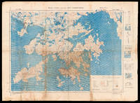
Hong Kong and the New Territories. North Sheet.: The liberation of Hong Kong from Japanese Occupation
by BRITISH WAR OFFICE
- Used
- Condition
- Used
- Quantity Available
- 1
- Seller
-
London, United Kingdom
- Item Price
-
£7,000.00£15.00 shipping to USA
Show Details
Description:
[London], : War Office, , Aug[ust] 1945.. 780 by 1050mm. (30.75 by 41.25 inches).. Chromolithograph map with manuscript annotations in pencil and pen, with three insets and diagrams to right margin, minor browning, a few nicks and tears to margins. A unique map of Hong Kong and the New Territories, with contemporary manuscript annotations showing the liberation of Hong Kong from Japanese occupation. This map, which shows Hong Kong, Kowloon and the New Territories, was first published by the British War Office in 1936. The present example, a second edition, was published shortly after the end of the Second World War, when Britain reoccupied the islands following four years of Japanese occupation. Thick red lines across the map indicate the "all weather roads" that could be relied upon for travel and communications across the region. Extending from Lantau Island to the west to Mirs Bay in the east, from the Chinese city of Shenzhen in the north to the southern Soko Islands, it is generally considered…
Read More Item Price
£7,000.00
£15.00
shipping to USA

Hong Kong and the New Territories. North Sheet.: Hong Kong after Japanese occupation
by BRITISH WAR OFFICE
- Used
- Condition
- Used
- Quantity Available
- 1
- Seller
-
London, United Kingdom
- Item Price
-
£750.00£15.00 shipping to USA
Show Details
Description:
[?London], : War Office,, Aug[ust] 1945.. 780 by 1050mm. (30.75 by 41.25 inches).. Chromolithograph map, with three insets and diagrams to right margin, browning and tears to left margin. An important map of Hong Kong and the New Territories published by the British War Office in 1945. Following the end of the First Opium War in 1942, China ceded Hong Kong to Great Britain and the island became a Crown Colony of the extensive Empire. Throughout the following decades, Britain guarded the territory closely, becoming increasingly concerned about the security of its port, which was essential for trade. The government therefore decided to create a buffer zone around the island to defend it against incursions from the nearby Chinese areas. The first part of this buffer was formed by Kowloon in 1860, when Britain took control of the peninsula in the aftermath of the Second Opium War. Further reinforcement came in 1898, when Britain gained a 99 year lease for 200 small islands surrounding Hong Kong, which…
Read More Item Price
£750.00
£15.00
shipping to USA
Map of Nanking: General Staff map of Nanking Compiled, drawn and printed at the War Office, 1927.
by War Office, Geographical Section, General Staff
- Used
- Condition
- Used
- Quantity Available
- 1
- Seller
-
London, United Kingdom
- Item Price
-
£3,500.00£15.00 shipping to USA
Show Details
Description:
War Office, Geographical Section, General Staff, 1927.. 745 by 995mm. (29.25 by 39.25 inches).. Coloured lithograph map dissected into 32 (4 by 8) sections mounted on linen. Scale 1:250,000 Nanking in 1927 was a treaty port located on the southern shores of the Yangtze River. Because the foreign interests in China were largely American and European, squadrons of foreign naval vessels were stationed along the Yangtze to protect their citizens doing business at the treaty ports. The British Royal Navy operated the China Station under Rear Admiral Sir Reginald Tyrwhitt and the United States Navy the Yangtze Patrol; both lasted for around 80 years until World War II.
Item Price
£3,500.00
£15.00
shipping to USA
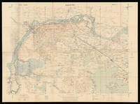
Map of Hong Kong and the Territory leased to Great Britain: Hong Kong - the ailing Qing dynasty leased to Great Britain, 1898 under the Convention between Great Britain and China, signed at Peking on the 9th of June 1898.
by War Office, Geographical Section, General Staff
- Used
- Condition
- Used
- Quantity Available
- 1
- Seller
-
London, United Kingdom
- Item Price
-
£7,000.00£15.00 shipping to USA
Show Details
Description:
Hong Kong,, 1922.. 665 by 860mm. (26.25 by 33.75 inches) .. Colour lithographed map, dissected and mounted on linen, folding map. An early, attractive, and detailed map of Hong Kong and the New Territories first published in 1905 and re-issued with additions in 1922. From another example of this chart we have handled, it appears that the coastline from Sai Kung to Mirs Point onwards was taken from Admiralty charts; that of Deep Bay, from the mouth of the Sham Chun River to South-West Point, from a survey by the P.W.D.; thence northward and westward from Admiralty charts; that of Lan Tao and adjacent islands from a 1-inch map compiled by Tate; and the New Territories from a map compiled by W. J. Newland in 1903-04, with additions and revisions by P.W.D. in 1913 and 1922. As listed in the Reference table, the map shows Important Villages & Market Places; Villages; Churches & Mission Stations; Pagodas & Temples; Pass; Heights in Feet above Sea Level; Bridges; Limit of Navigation for Large Junks; Cart…
Read More Item Price
£7,000.00
£15.00
shipping to USA

Sell Variety of Books in all Faculties and Sciences, at their Shop, over-against the Black-Swan in Coney-Street, York, and at the Corner of the Long-Room Street, at Scarbrough; With great Choice of Maps, Prints, Books of Roads; &c. Likewise all Sorts of Stationary Wares. The said Ward and Chandler being supplied at their Shops in York and Scarbrough, from their own Shop at Temple-Barr, the Publick may therefore depend on being serv'd by them, as cheap in both those Places, as in London
by WARD, Cesar; and Richard CHANDLER
- Used
- Condition
- Used
- Quantity Available
- 1
- Seller
-
London, United Kingdom
- Item Price
-
£750.00£15.00 shipping to USA
Show Details
Description:
London,: At the Ship, without Temple-Barr, , [1737-1744].. 110 by 90mm. (4.25 by 3.5 inches).. Prints,""Cesar Ward and Rich.d Chandler, Booksellers, ... Booksellers of York and Scarborough Engraved trade card. Engraved by J. Haynes of York, the cartouche bears two portraits, probably of Ward and Chandler themselves. Chandler (c1713-1744), was the son of Robert Chandler (c1671-1726), periwig maker and freeman of the BarberSurgeons' Company, of Carey Street, London. """"Chandler was apprenticed on 7 November 1727 for a premium of £49 10s. to the bookseller John Hooke whose shop was at the sign of the Fleur de Luce near St Dunstan's Church in the parish of St Dunstan in the West, Fleet Street, London. It may have been about this time that Chandler met Caesar Ward (1710-1759), later his business partner, for Ward was apprenticed at the same time to another bookseller in that parish, Robert Gosling. Hooke died in September 1730 before Chandler could complete his apprenticeship. Chandler was freed by…
Read More Item Price
£750.00
£15.00
shipping to USA

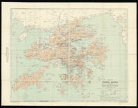
Map of the Country around Shanghai: Big-Game Hunting in and around Shanghai compiled from the best authorities with numerous additions from actual survey.
by WATERS, Thomas J.
- Used
- Hardcover
- Condition
- Used
- Binding
- Hardcover
- Quantity Available
- 1
- Seller
-
London, United Kingdom
- Item Price
-
£6,500.00£15.00 shipping to USA
Show Details
Description:
[?Shanghai],, 1880.. 880 by 960mm. (34.75 by 37.75 inches).. Lithographed map, dissected and laid down on linen in 24 sections, with contemporary hand-colour in full; preserved in original publisher's green cloth slipcase. Compiled by Thomas Waters (1842-1898), "expressly for Sportsmen" (slipcase label). Waters was an Irish civil engineer and architect who carved out a successful early career in Japan, designing the Imperial Mint in Osaka and the headquarters for the Imperial Japanese Army. He worked briefly in Shanghai in the 1880s, before going out to Colorado to join his brothers in silver and gold mining. This map also appeared in cyanotype, probably originally drawn up as part of Waters' bid for the commission to construct a new waterworks in Shanghai. Waters was a strong contender in the competition, as he had experience in the field: he was partially responsible for the construction of Japan's first sewer system. Rare: OCLC locates only two institutional examples, those in the BnF and…
Read More Item Price
£6,500.00
£15.00
shipping to USA
Map of the Country around Shanghai: Big-Game Hunting in and around Shanghai compiled from the best authorities with numerous additions from actual survey.
by WATERS, Thomas J.
- Used
- Hardcover
- Condition
- Used
- Binding
- Hardcover
- Quantity Available
- 1
- Seller
-
London, United Kingdom
- Item Price
-
£8,500.00£15.00 shipping to USA
Show Details
Description:
[?Shanghai],, 1880.. 880 by 960mm. (34.75 by 37.75 inches).. Lithographed map, dissected and laid down on linen in 24 sections, with contemporary hand-colour in full; preserved in original publisher's green cloth slipcase, with accompanying 5 sheet key in phonetic English and Chinese. Compiled by Thomas Waters (1842-1898), "expressly for Sportsmen" (slipcase label). Waters was an Irish civil engineer and architect who carved out a successful early career in Japan, designing the Imperial Mint in Osaka and the headquarters for the Imperial Japanese Army. He worked briefly in Shanghai in the 1880s, before going out to Colorado to join his brothers in silver and gold mining. DCRB holds another example of this map in Cyanotype, probably originally drawn up as part of Waters' bid for the commission to construct a new waterworks in Shanghai. Waters was a strong contender in the competition, as he had experience in the field: he was partially responsible for the construction of Japan's first sewer system.…
Read More Item Price
£8,500.00
£15.00
shipping to USA

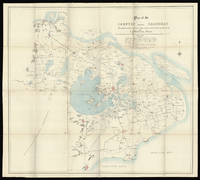
Plan of the country around Shanghai: Cyanotype plan of Shanghai Compiled from the best Authorities with numerous additions from Actual Survey
by WATERS, T.J.
- Used
- Condition
- Used
- Quantity Available
- 1
- Seller
-
London, United Kingdom
- Item Price
-
£6,000.00£15.00 shipping to USA
Show Details
Description:
Shanghai,, [c1890].. 880 by 960mm. (34.75 by 37.75 inches).. Cyanotype map. A cyanotype map of Shanghai. Cyanotypes are created by using paper soaked in a photosensitive ferro-gallate solution. When the paper is exposed to sunlight, it turns blue. The original map would have been laid on top of the ferro-gallate paper, and the printed lines of the original created the white lines on the cyanotype. The original map was compiled by Thomas Waters (1842-98). Waters was an Irish civil engineer and architect who carved out a successful early career in Japan, designing the Imperial Mint in Osaka and the headquarters for the Imperial Japanese Army. He worked briefly in Shanghai at the end of the 1880s, before going out to Colorado to join his brothers in silver and gold mining. The map may have been drawn up as part of Waters' bid for the commission to construct a new waterworks in Shanghai. Waters was a strong contender in the competition, as he had experience in the field: he was partially responsible…
Read More Item Price
£6,000.00
£15.00
shipping to USA

Didn’t find what you’re looking for?
Try adding this search to your want list. Millions of books are added to our site everyday and when we find one that matches your search, we’ll send you an email. Best of all, it’s free.
Add to Want List

Are you a frequent reader or book collector?
Join the Bibliophile's Club and save 10% on every purchase, every day — up to $20 savings per order!

Social Responsibility
Did you know that since 2004, Biblio has used its profits to build 16 public libraries in rural villages of South America?
