Description:
Bonn,, c.1770.. 393 by 475mm. (15.5 by 18.75 inches).. Folding engraved map with contemporary hand-colour in outline. A scarce map showing the Battle of Chesma in 1770, fought between Russian and Ottoman fleets during the Russo-Turkish War (1768-1774). The battle was fought in the prelude to the Greek War of Independence, and was a crushing defeat for the Ottoman navy. The accompanying French text is based upon a Russian map 'Plan Pobedy Imperatorskim Rossiiskim Flotom pod Kommando In Generala Grafa Orlova Nad Turetskim'. The engraver Georg Sigismund Facius was born in Regensburg in 1750 and was educated together with his twin brother Johann Gottlieb in Brussels, where their father was working as Russian consul. They worked in Bonn in the early 1770s and produced several maps concerning the Russo-Turkish War. In 1776 they moved to London, where they worked for Boydell as print engravers. No examples recorded in libraries worldwide.
Search Results: Authors starting with F from Daniel Crouch Rare Books Ltd
You searched for:
- Bookseller inventory: Daniel Crouch Rare Books Ltd (authors starting with F)
- Bookseller: Daniel Crouch Rare Books Ltd
Results 1 - 20 of 21

Plan traduit et copie de l'original Russie de la Victoire remportee le 24th Juin, 5 Juillet 1770 par la Flotte Imperiale de Russie: The Battle of Chesma sous le Commandement du General Comte d'Orloff, sur la Turque.
by FACIUS, G. S.
- Used
- Condition
- Used
- Quantity Available
- 1
- Seller
-
London, United Kingdom
- Item Price
-
£4,000.00£15.00 shipping to USA
Show Details
Item Price
£4,000.00
£15.00
shipping to USA

Plan of the Coast of Cherbourg,: Rare broadside plan of Cherbourg with a Sketch of the Works which the French are now executing to Inclose and Defend the Road, &c. Third Edition Revised, Corrected and Improved.
by FADEN, William
- Used
- Condition
- Used
- Quantity Available
- 1
- Seller
-
London, United Kingdom
- Item Price
-
£1,200.00£15.00 shipping to USA
Show Details
Description:
[London], Published as the Act directs, by W[illia]m Faden, Geog[raphe]r to the King, Charing Cross,, Jan[uar]y 1st, 1788.. 700 by 510mm (27.5 by 20 inches).. Broadside engraved plan, original outline hand-colour, inset plan of the 'conical caissons' letterpress text below. Rare separately issued plan of Cherbourg. The plan gives detailed information on the defences at Cherbourg in 1788, with the position of the forts, redoubts and the reach of their cannon and mortar; together with the placement and construction of the 'Trucated Cones, or Conical Caissons'. These large wooden structures - some 170 feet in diameter - were being placed at the harbour's mouth in order to narrow its entrance. The plan and the text below goes into considerable detail upon their construction and to how they were placed in the harbour. Although not at war with the French at the time, the plan highlights England's continued concern about the strength and defences of the French channel ports and their interest in French…
Read More Item Price
£1,200.00
£15.00
shipping to USA

A New Pocket Plan of the Cities of London and Westminster: Plan of London showing troop dispositions with the borough of Southwark: Comprehending the New Buildings and Alterations to the Year 1803.
by FADEN, William
- Used
- Condition
- Used
- Quantity Available
- 1
- Seller
-
London, United Kingdom
- Item Price
-
£1,500.00£15.00 shipping to USA
Show Details
Description:
London,: Published by W. Faden, Geographer to the King and to the Prince of Wales, Charing Cross,, 1803.. 465 by 1030mm (18.25 by 40.5 inches).. Engraved plan on two sheets, original outline hand-colour, manuscript annotations to map with manuscript key to right margin, a few old tears skilfully repaired and old folds reinforced. The plan gives information on parishes, in Westminster, Surrey, and Middlesex, with the Bills of Mortality. A coloured key shows the limits of the City of London, the intended buildings or new streets not finished, the Liberties of Westminster, and Rules of the Bench and Fleet. The border is divided into miles and furlongs based on St Paul's, and intended and unfinished development includes the area east of the Edgware Road and south of Euston Road; a circus at the east end of the Strand; and the London Docks. However, the most important feature of this map is the additional coloured key in a manuscript note to the right hand margin. This shows the disposition of troops,…
Read More Item Price
£1,500.00
£15.00
shipping to USA
![[Composite atlas].](https://d3525k1ryd2155.cloudfront.net/h/195/910/1162910195.0.m.jpg)
More Photos
[Composite atlas].: The best British mapmakers of the late eighteenth century
by FADEN, William; WHITTLE, James and LAURIE, Robert; BOWLES, Henry Carington and CARVER, Samuel
- Used
- Hardcover
- Condition
- Used
- Binding
- Hardcover
- Quantity Available
- 1
- Seller
-
London, United Kingdom
- Item Price
-
£20,000.00£15.00 shipping to USA
Show Details
Description:
London,: William Faden; Laurie & Whittle; Bowles & Carver, 1783-1797.. Folio (564 by 440 mm). Contemporary manuscript Contents page, 49 numbered mapsheets, 2 full-page, the others double page and or folding, two maps each bound in two separate sheets, all but one with fine contemporary hand-colour in full, part or outline, some maps reinforced with linen at folds on verso, contemporary half calf, marbled paper boards, the spine in seven compartments, the title gilt-lettered in one, the others decorated with gilt armillary spheres, a bit worn. A composite atlas, including maps by the best British mapmakers of the late eighteenth century, the majority by William Faden, three published by Henry Carington Bowles and Samuel Carver, and three by Robert Laurie and James Whittle (one in conjunction with Bowles & Carver). Most of the Faden maps have clearly been coloured by the same hand. The atlas covers mainly western Europe and the Mediterranean. Interestingly, a map of Brunswick-Luneberg has been…
Read More Item Price
£20,000.00
£15.00
shipping to USA

A Chart Shewing the North West Passage Discovered by Capt. R. le M. McClure: The first man to traverse the Northwest Passage H.M. Ship Investigator; also the Coast Explored in Search of Sir J. Franklin, by Sir Jas. Ross 1848 & 9... Capt. Sir Edwd. Belcher 1852 & 53... by E.A. Inglefield, Commander H.M.S. Phoenix.
by FAWEKNER, W. H.
- Used
- Condition
- Used
- Quantity Available
- 1
- Seller
-
London, United Kingdom
- Item Price
-
£20,000.00£15.00 shipping to USA
Show Details
Description:
London,: Hydrographic Office, Admiralty,, 14 October 1853.. 475 by 945mm (18.75 by 37.25 inches).. Lithograph chart, manuscript inscription upper left, mounted on linen, Admiralty stamp below title, stain above title, a few minor tears to margins skilfully repaired, loss to lower right corner repaired not affecting image. This is the first chart to show McClure's ground-breaking discovery of the North-West Passage. Travelling on board the Investigator in 1850, Robert McClure led one of the many expeditions launched in search of explorer James Franklin, who had become trapped in the Arctic while searching for the seaway linking the Atlantic and Pacific Oceans. In doing so, McClure himself became the first man credited with navigating the North-West Passage, although he made much of his journey over ice rather than by sea, his path represented on this chart by a solid line. Passing through the Bering Strait (here labelled Behring's Strait), McClure discovered and named the even narrower Prince of…
Read More Item Price
£20,000.00
£15.00
shipping to USA

A New Globe of the Earth by James Ferguson.: The coast (of Australia) is clear
by FERGUSON, James
- Used
- Condition
- Used
- Quantity Available
- 1
- Seller
-
London, United Kingdom
- Item Price
-
£14,000.00£15.00 shipping to USA
Show Details
Description:
[London],: James Ferguson, J. Mynde Sc. [engraver], , [c1775].. Diameter: 76mm (3 inches).. Globe, 12 hand-coloured engraved paper gores, over papier mâché and plaster sphere, varnished, housed in original shagreen case with rims painted red and two original brass hooks and eyes. Biography James Ferguson (1710-1776) was a Scottish autodidact who settled in London after a peripatetic life involving spells as a shepherd, miller, engineer, astronomer and lecturer. In his autobiography, he claims that, at the age of 20, he "made a globe in three weeks at my father's, having turned the ball thereof out of a piece of wood, which ball I covered with paper, and delineated a map of the world upon itmade the meridian ring and horizon of woodcovered them with paper, and graduated them" (Ferguson, p.21). In 1755, he purchased the vast majority of the plates and instruments previously owned by John Senex, a leading producer of pocket globe. Ferguson subsequently designed his own pocket globe and produced…
Read More Item Price
£14,000.00
£15.00
shipping to USA
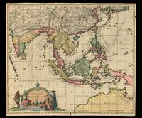
nec non Insularum Adiacentium Nova Descriptio Auctore Jac.o de la Feuille. Cum Privilegio Ordinum Hollandiae et West-frisiae.
by FEUILLE, Jacob de la
- Used
- Condition
- Used
- Quantity Available
- 1
- Seller
-
London, United Kingdom
- Item Price
-
£3,000.00£15.00 shipping to USA
Show Details
Description:
[Amsterdam,, c1696].. 550 by 635mm. (21.75 by 25 inches).. Maps,""Indiae Orientalis One of only three examples known Engraved map with contemporary hand-colour in full. Rare printing by Jacob de la Feuille (1668-1719), son of Daniel de la Feuille, of Nicolas Visscher's 1670 map of Southeast Asia. The map extends to include India, Ceylon, the Maldives, part of China, the East Indies, the Philippines, southern Persia, and the northern coast of Australia, depicted as """"Hollandia Nova"""". Jacob de Feuille acquired a number of engraved cartographical plates through his marriage in 1696 to Maria de Ram, the widow of Johannes de Ram (1648-93), and this map is clearly printed from the same plate as de Ram's map of the same title, c1683, with Feuille's name substituted for de Ram's. It is also almost identical to De Wit's 1688 map of the same title. In his imprint, de Wit describes the map as """"Editia"""" (edited) by him, whereas both de Ram and Feuille, in their imprints, attest that the map is…
Read More Item Price
£3,000.00
£15.00
shipping to USA

Vue Générale de Londres: Devil's Acre" Prise au dessus du Park St James.
by FICHER, Charles after FICHOT Ch[arles]; [printed by] BECQUET
- Used
- Condition
- Used
- Quantity Available
- 1
- Seller
-
London, United Kingdom
- Item Price
-
£2,500.00£15.00 shipping to USA
Show Details
Description:
Paris,: Ledot Jerome, 168 rue de Rivoli, Grand Hotel du Louvre,, [after 1852].. Image: 412 by 605mm. (16.25 by 23.75 inches). Sheet: 543 by 730mm. (21.5 by 28.75 inches).. Lithograph. Fichot's print is broadly based upon Appert's c1850 birds'-eye view (items 32-35). The main difference is the addition of Victoria Street, built in 1851, partly on the site of a slum dubbed "Devil's Acre" by Charles Dickens. Charles Fichot (1817-1903) was a French lithographer, who settled in Paris in 1852, giving an approximate date for the print.
Item Price
£2,500.00
£15.00
shipping to USA

The Elephant and Castle on the Road to Brighton.: The Elephant and Castle
by FIELDING, Theodore, after POLLARD, James
- Used
- Condition
- Used
- Quantity Available
- 1
- Seller
-
London, United Kingdom
- Item Price
-
£2,000.00£15.00 shipping to USA
Show Details
Description:
London,: Published by J. Watson, 7 Vere Street,, Feb. 7th, 1826.. Image: 540 by 766mm (21.25 by 30.25 inches). Sheet: 626 by 815mm (24.75 by 32 inches).. Engraving with aquatint and hand-colour. The Elephant and Castle Inn was a public house and busy staging post, probably deriving its name from the coat of arms of the Cutler's Guild, which feature an elephant as a nod to the use of ivory in cutlery handles. It gives its name to the present area of London. There are a variety of vehicles going past the inn, including a private coach, stage coaches going to Bognor and Brighton, and a wagon. Museum of London 002039.
Item Price
£2,000.00
£15.00
shipping to USA

Dealer in Stourbridge Bricks, Fire Clay &c. Flatening. Tiles, Patent Stove. Liners, Class Pots &c. NB Engine for hire.
by FITCHETT, Jo[h]n
- Used
- Condition
- Used
- Quantity Available
- 1
- Seller
-
London, United Kingdom
- Item Price
-
£200.00£15.00 shipping to USA
Show Details
Description:
Birmingham,: 33, Potter Street,, [c1837-1849].. 60 by 90mm. (2.25 by 3.5 inches).. Prints,""J.No. Fitchett Casting Pot and Muffle, Manufacturer... M is for Muffle Maker Engraved trade card. Trade card of John Fitchett, who was listed as having appeared as """"the court for relief of insolvent debtors"""" in Warwick on March 28, 1833, but who appears to have later revivified his brick-making business. He is listed in both 'Pigot and co.'s national commercial directory' of 1837 and 'Birmingham: History and General Directory of the Borough of Birmingham' from 1849 as active at 33 Potter Street. The present trade card, which is illustrated with engravings of various industrial items and machinery, with a weathered tree and large ship in the background, advertises a number of products and services. Fitchett manufactured casting pots and muffles for making bricks; a muffle furnace is one operated with an externally heated chamber which radiates heat inwards, so that the material within has no direct…
Read More Item Price
£200.00
£15.00
shipping to USA

UCLA.: This is Frat Row" University of California. Los Angeles.
by FORD, Mark and Wayne HARLOW
- Used
- Condition
- Used
- Quantity Available
- 1
- Seller
-
London, United Kingdom
- Item Price
-
£1,500.00£15.00 shipping to USA
Show Details
Description:
Loma Linda, CA,: Creative Visual Communications,, 1983.. 595 by 885mm. (23.5 by 34.75 inches).. Colour printed poster mounted on linen. This map depicts an aerial view of UCLA (University of California Los Angeles) with bold graphics and decorative detail. The view highlights the university with stylised depictions of the campus, including academic halls, student residences and sports arena. Throughout the map there are small caricature depictions of figures and accompanying humorous phrases, including a marching band leader saying "we toot our own horns". The fraternities and sororities on campus are represented by figures holding up their Greek letters, with a sorority member warning two passing men, "wait fellas, girls only". The poster is up to date with the latest information, including one group of people noting "this is the 1984 Olympics Committee Headquarters". UCLA was a major venue for the Los Angeles Olympics in 1984, with the residence halls housing more than 4,000 people and Pauley…
Read More Item Price
£1,500.00
£15.00
shipping to USA

Venetia: Forlani's magnificent plan of Venice AL SIG. GIROLAMO MVRARI, / Paolo Forlani Veronese. / VENETIA Città marauigliosa, Magnifico Signor mio, / da tutto l'uniuerso per fama conosciuta, et celebrata, à richiesta / di molti honorati Gentil'huomeni con non p
by FORLANI, Paolo; ZALTIERI, Bolognini
- Used
- Condition
- Used
- Quantity Available
- 1
- Seller
-
London, United Kingdom
- Item Price
-
£30,000.00£15.00 shipping to USA
Show Details
Description:
Venice,: ex aenis formis Bolognini Zalterii,, 1566.. 437 by 736mm. (17.25 by 29 inches).. Forlani state 4, Zaltieri state 3, separately issued. 2 sheets joined. Engraved view (355 by 735mm) above 23-line engraved key (horizontal separation between view and text repaired, old folds, close-cropped, left and right-hand margins with minor repairs). Magnificent, large-scale, bird's-eye view of Venice, first published in 1565, this is the third issue to bear Zaltieri's imprint and features the printed impressions of a horizontal row of rivets where the printers had attempted to join the engraved plates of the view and the key. Shown from the same perspective as Jacopo de' Barbari's monumental woodcut map of c1500, Venice is seen rising like Venus fully formed from the lagoon, witnessed by an array of satellite islands and watercraft, the Venetian mainland compressed to a thin band at the horizon and to the left. Each canal, bridge and building is meticulously depicted and named in the comprehensive key…
Read More Item Price
£30,000.00
£15.00
shipping to USA

La nuova et esatta descrittione della soria, e della Terra Santa.: Forlani's map of the Holy Land
by FORLANI, Paolo
- Used
- Condition
- Used
- Quantity Available
- 1
- Seller
-
London, United Kingdom
- Item Price
-
£13,000.00£15.00 shipping to USA
Show Details
Description:
Venetia,: Paolo Forlani,, 1566.. 272 by 355mm. (10.75 by 14 inches).. Double-page engraved map. Printed from a possible discarded first issue plate, with the date in the title cartouche in Roman numerals, rather than Arabic, and with the line break after 'esatta' in the title. An unusual map showing the coast of the Holy Land with Cyprus, and the Levant coast to the south of the Dead Sea, engraved and published by Paolo Forlani. The map is based on Martin Waldseemüller's cartography in the 1513 edition of Ptolemy's 'Geographia': Forlani probably saw Giordano Ziletti's edition published in Venice in 1561, enlarged it and added the decorative title cartouche and the wind rose. The variant with Arabic numerals appears in two states, the second published by Donato Bertelli. There are institutional examples in the Danish National Library, Leiden University Library, National Library of Israel and the Bibliothèque nationale de France. Laor, Holy Land, 864; Meurer, Strabo, p.123; Tooley, Italian…
Read More Item Price
£13,000.00
£15.00
shipping to USA
![The County of Lanark from Actual Survey by Will[ia]m Forrest.](https://d3525k1ryd2155.cloudfront.net/h/399/505/1391505399.0.m.jpg)
The County of Lanark from Actual Survey by Will[ia]m Forrest.: Forrest's large-scale survey of West Lothian To the Right Honourable John, Earl of Hopetown, Viscount Atherley, Lord Hope, ... and Lord Lieutenant of the County of Linlithgow etc. This map is Most Respectfully Inscribed by His Lordship's Most Obedient and
by FORREST, Will[ia]m
- Used
- Condition
- Used
- Quantity Available
- 1
- Seller
-
London, United Kingdom
- Item Price
-
£2,500.00£15.00 shipping to USA
Show Details
Description:
Edinburgh,: W. Forrest,, 1818.. 1780 by 1280mm (70 by 50.5 inches).. Large engraved map, fine original full-wash colour, dissected and mounted on linen, in two sections, housed in original green morocco slipcase, spine in compartments and lettered in gilt. An outstanding example of a scarce Scottish large-scale survey. A superb map of the area now know as West Lothian and embracing the old parishes of Torphichen, Bathgate, Whitburn, Bo'ness, Kirkliston, Linlithgow, Uphall, Abercon, Dalmeny and Cramond, etc. Much detail is shown including kirks, burns and lochs, Roman and Danish camps, and the Antonine Wall. NLS EMS.s.33.
Item Price
£2,500.00
£15.00
shipping to USA
![[A set of two globes and one armillary sphere]](https://d3525k1ryd2155.cloudfront.net/h/288/507/1391507288.0.m.jpg)
More Photos
[A set of two globes and one armillary sphere]: Ingenieur-Mechanicien pour les Globes et Spheres" Globe terrestre sur le quel Les Principaux Points sont placez sur les dernieres Observations de Mrs de l'Academie Royale des Sciences Par M. Buy de Mornas Geographe du Roi et des Enfants de France, [and] G
by FORTIN, [Jean] and BUY DE MORNAS, M. [Claude]
- Used
- Condition
- Used
- Quantity Available
- 1
- Seller
-
London, United Kingdom
- Item Price
-
£40,000.00£15.00 shipping to USA
Show Details
Description:
Paris,: Chez le Sr. Fortin, Ingenieur, Mecanicien du Roy pour les Globes et Spheres, rue de la Harpe, 1768 [celestial globe dated 1770, armillary dated 1773].. 220mm (8.75 inches). . A pair of terrestrial and celestial globes, each with 12 hand-coloured engraved paper gores over papier mâché and plaster sphere, varnished, paste-board meridian ring, wooden horizon ring, raised by four quadrant supports, mounted on an ebonized turned wood table stand. Together with an armillary sphere, containing globe with 12 hand-coloured engraved gores, over a papier mâché and plaster sphere, varnished wood, raised on four quadrant supports, with ebonised turned wood table stand. Biography Jean Fortin (1750-1831) was a scientific instrument-maker born in Picardy, France. Chiefly remembered for designing a barometer that ensured more accurate readings, he also produced celestial atlases, scales and was commissioned by the French royal family to make globes. He made terrestrial and celestial globes of 320 and…
Read More Item Price
£40,000.00
£15.00
shipping to USA

The Seat of War in the West Indies: Rare map published during the War of Jenkin's Ear containing New and Accurate Plans of the Havana, La Vera Cruz, Cartagena and Puerto Bello (taken from Spanish Draughts)
by [FOSTER, G.]
- Used
- Condition
- Used
- Quantity Available
- 1
- Seller
-
London, United Kingdom
- Item Price
-
£2,500.00£15.00 shipping to USA
Show Details
Description:
London,: W. Nicoll in St Pauls Church Yard,, [c1762].. 425 by 470mm. (16.75 by 18.5 inches).. Five engraved maps, and panoramic view on a single sheet, with contemporary hand-colour in outline to the chart of the West Indies. Rare separately issued edition, published during the Seven Years' War by William Nicoll, first issued during the War of Jenkin's Ear. At the upper left is a general map of the West Indies, and the other nine plans and views show important ports throughout the region, each is annotated with details of the defences and their military history: "A Map or Chart of the West Indies, drawn from the best Spanish Maps, and regulated by Astronomic Observations", with insets of the "Harbour of San Augustin on the Coast of Florida", and the "Bay of Honda or the Deep Bay in Cuba", "The Harbour of Puerto Bello", "Plan of the Harbour of Cartegena", "La Vera Cruz or San Juan de Ulua, The Barrador or Port of Mexico" with insets of the towns and harbours of Vera Cruz and San Juan de Ulua,…
Read More Item Price
£2,500.00
£15.00
shipping to USA

A Perspective View of the Engine, made use of for Sawing off under Water, The Piles which help'd to support the Centers, for turning the Arches of Westminster Bridge: An underwater saw most humbly inscribed to the Right Honble. The Commissioners for building the said Bridge by the Inventor.
by FOURDRINIER, Paul after LABELYE, Charles
- Used
- Condition
- Used
- Quantity Available
- 1
- Seller
-
London, United Kingdom
- Item Price
-
£950.00£15.00 shipping to USA
Show Details
Description:
[London],, May 1, 1745.. Iamge: 414 by 331mm (16.25 by 13 inches). Sheet: 565 by 415mm (22.25 by 16.25 inches).. Engraved print with manuscript annotation. An intriguing print showing an underwater saw, signed by the inventor. The inventor, William Etheridge (1709-1776) was a master carpenter. He worked with James King to build the first bridge at Westminster, and took over as foreman after King died. As well as the underwater saw, he also invented a battering ram to help strike the centres. He also worked on the Walton Bridge and designed Queens' Bridge in Cambridge. His name and profession has been added by hand to the dedication. The project the saw was invented for was Westminster Bridge, designed by Charles Labelye (1705-62), an engineer and architect. Labelye was given the project in 1738 and initially designed a timber superstructure augmented with stone. However, during the severe winter of 1739-40 the Thames froze and the existing timber was destroyed. Labelye regrouped and designed a…
Read More Item Price
£950.00
£15.00
shipping to USA

Palestinae sive Terre Sancte descriptio... MDLVII.: Franciscus's map of the Holy Land
by FRANCISCUS DELLA GATTA, Johannes
- Used
- Condition
- Used
- Quantity Available
- 1
- Seller
-
London, United Kingdom
- Item Price
-
£12,000.00£15.00 shipping to USA
Show Details
Description:
Rome,, 1557.. 385 by 540mm. (15.25 by 21.25 inches).. Broadsheet engraved map tipped-in to album sheet. Fine example of this extremely rare map of the Holy Land. Franciscus's map of the Holy Land is a remarkable combination of bird's eye view and map. "The shore line runs from Biblus as far as the Nile Delta. The Kishon River is shown connecting the Lake of Tiberias with the Mediterranean Sea. The Wandering of the Jews from Egypt as far as the Jordan River are depicted in military columns. Many biblical cities are shown on the map. Jerusalem is depicted as an impressive city" (Laor). To the upper left is a key to biblical place names, contained within an elaborate cartouche of cupids and tritons. The map is based upon Wolfgang Wissenberg's larger map of the Holy Land published 1537, and dedicated to Archbishop Thomas Cranmer. The map was printed upon eight sheets and measured 105 by 74 cm. Unfortunately, Wissenberg's map is known in only one example, housed in the Bibliotheque Nationale de Paris.…
Read More Item Price
£12,000.00
£15.00
shipping to USA

James Fraser's Panoramic Plan of London: A complete bijou of a map, not less useful than elegant" Dedicated to Her Most Gracious Majesty Queen Adelaide. Engraved by Jas. Neale & Co. Burleigh St. Strand.
by FRASER, James
- Used
- Hardcover
- Condition
- Used
- Binding
- Hardcover
- Quantity Available
- 1
- Seller
-
London, United Kingdom
- Item Price
-
£1,250.00£15.00 shipping to USA
Show Details
Description:
London, 215 Regent Street,: James Fraser,, 1837.. 410 by 550mm (16.25 by 21.75 inches).. Engraved map, dissected and mounted on linen, hand-coloured in outline, bordered with 18 engraved views of some of the principal attractions of London, housed within original green cloth folder, bookseller's ticket on pastedown "Sold by John Bubb, Bradford", with printed label on upper cover, spine worn and repaired. The eighteen views surrounding the map depict the New Post Office, Italian Opera House, Queen's New Palace, Entrance to Hyde Park, Custom House, National Scottish Church, Drury Lane, Somerset House, Westminster Abbey, The Colosseum, Covent Garden Theatre, Thames Tunnel, St Paul's, Waterloo Bridge, Bank of England, New London Bridge, London University and Hammersmith Suspension Bridge. According to Fraser's advertisement, the map was available at four different prices, starting at 7s 6d in a French Case to 16s in a black frame, our example is the more humble 3s issue in cloth. The reviews were…
Read More Item Price
£1,250.00
£15.00
shipping to USA

Fraser's Panoramic Plan of London: A complete bijou of a map, not less useful than elegant" Dedicated to Her Most Gracious Majesty Queen Adelaide. Engraved by Jas. Neale & Co. Burleigh St. Strand.
by FRASER, James
- Used
- Hardcover
- Condition
- Used
- Binding
- Hardcover
- Quantity Available
- 1
- Seller
-
London, United Kingdom
- Item Price
-
£1,250.00£15.00 shipping to USA
Show Details
Description:
London,: James Fraser, 215 Regent Street,, 1834.. 410 by 560mm. (16.25 by 22 inches).. Engraved map, dissected and mounted on linen, hand-coloured in outline, bordered with 18 engraved views of some of the principal attractions of London, folding into original green cloth covers, with publisher's label. The eighteen views surrounding the map depict the New Post Office, Italian Opera House, Queen's New Palace, Entrance to Hyde Park, Custom House, National Scottish Church, Drury Lane, Somerset House, Westminster Abbey, The Colosseum, Covent Garden Theatre, Thames Tunnel, St Paul's, Waterloo Bridge, Bank of England, New London Bridge, London University and Hammersmith Suspension Bridge. According to Fraser's advertisement, the map was available at four different prices, starting at 7s 6d in a French Case to 16s in a black frame, our example is the more humble 3s issue in cloth. The reviews were handsome, the Literary Gazette calling the publication "A complete bijou of a map, not less useful than…
Read More Item Price
£1,250.00
£15.00
shipping to USA

Didn’t find what you’re looking for?
Try adding this search to your want list. Millions of books are added to our site everyday and when we find one that matches your search, we’ll send you an email. Best of all, it’s free.
Add to Want List

Are you a frequent reader or book collector?
Join the Bibliophile's Club and save 10% on every purchase, every day — up to $20 savings per order!

Social Responsibility
Did you know that since 2004, Biblio has used its profits to build 16 public libraries in rural villages of South America?
